


Introduction
The complexities of seasonality have all too often been reduced to the tired formula of a repeating seasonal cycle, a there-and-back walk up and down the hill. In this article, I am proposing a more relational understanding of seasonality as an arena for investigating the close attention and interdependence among humans and non-humans, enacted across place and time. This involves challenging our simplistic understandings of human settlement, both today and in much of the post-Mesolithic past, as stable and sedentary (Sheller & Urry, Reference Sheller and Urry2006: 208; Aldred, Reference Aldred and Leary2014: 23). It also confronts our simplistic models of time, whereby annual cycles are repeated and are put end-to-end so that they add up to an undeviating single line (Witmore, Reference Witmore, Hicks, McAtackney and Fairclough2007: 205). For all its apparently ongoing sequence, seasonality is complex and turbulent, often unpredictable. It offers an explicit perspective on an interdependent world, and simultaneously challenges it with contradiction and surprise.
My core aim is to develop a more relational understanding of seasonality, which is centred on close attention to rhythms, patterns, and ecological partners rather than dependent on the Cartesian grids of calendar and map (Aldred, Reference Aldred and Leary2014: 39; Overton, Reference Overton and Pilaar Birch2018). To do this, I will scrutinize the operation of mobile systems of interdependence between humans and non-humans, particularly summer grazing and arable fields remote from what are often called the ‘main’ settlements. My examples come from early modern Cyprus and Scotland, particularly in the eighteenth, nineteenth, and early twentieth centuries, which constitute a key transitional phase in both places (Figure 1). This work is part of a wider project that investigates the conviviality of all players in the landscape, human and non-human, material and sentient, across scales from microscopic to global and from ephemeral to epochal (see Given, Reference Given2018).

Figure 1. Seasonal activities, experiences, artefacts, materials, and human-non-human relationships: a) sieving grain in Cyprus, 1930s; b) using spade and cas-chrom (foot-plough) in Skye, c. 1880. a: © Collection of the Leventis Municipal Museum of Nicosia, Cyprus. b: Reproduced after Thompson, Reference Thompson1976: 77 by permission of Pavilion Books.
After discussing seasonality as a multispecies relationship of attending, I interpret my case studies within this framework under three headings. Addressing ‘the shape of the land’ is essential for understanding spatial and temporal variations in land use and other interactions, especially in areas of high topographic diversity. Investigating ‘routes and dates’ allows us to appreciate the importance of the actual movement and travel involved in these interactions. Placing the ‘margins at the centre’ emphasizes the vital role of seasonal activities, even when later commentators have dismissed or devalued them as marginal, peripheral, and isolated.
Seasonality: Attending to Place and Time
Discussions of seasonality in the archaeological literature are often reduced to an over-simplified ‘annual round’, a mechanical system of assigning people to particular sites at particular times of the year, which conveniently allows the analyst to identify a single function for each ‘site’ so that they can be classified according to ‘site types’ (e.g. Binford, Reference Binford1983: 131–38). This masks the great variability from year to year among different groups of people and livestock, who might be using the same sites at different times, as well as variation over the long term of a site's use (Conneller, Reference Conneller, Milner and Woodman2005). Even the productive notion of ‘persistent places’ (Schlanger, Reference Schlanger, Rossignol and Wandsnider1992: 97; Cummings, Reference Cummings, Larsson, Kindgren, Knutsson, Loeffer and Akerlund2003: 79), which generate different human activities and associations across long periods of time, tends to be static and all too easily represented by yet more dots on the map (Wright, Reference Wright2012: 97).
Instead, we can think of place-making as something that happens through movement: significance, memories, and relationships are created by patterns of walking, approaching, branching away, visiting, gathering (Gibson, Reference Gibson2007; Aldred, Reference Aldred2012, Reference Aldred and Pilaar Birch2018). Such meaningful patterns of intersecting place and time have long been observed by ethnographers among pastoral societies (e.g. Barth, Reference Barth1959), as have the pastoralists’ attentiveness and sensitivity to ecological variation (e.g. Dyson-Hudson & Dyson-Hudson, Reference Dyson-Hudson and Dyson-Hudson1980: 29, 51–52). Clearly there are specific places which gather specific activities at particular times: a fire-spot, a kill-site, a feeding trough, a regular early summer pasture, a reliable water hole in a dry year. These are nodes in an infinitely complex network of movement and interaction (Conneller, Reference Conneller, Milner and Woodman2005: 47–49; Burri, Reference Burri2014: 11–13); they inspire and contain particular performances at particular times (Sheller & Urry, Reference Sheller and Urry2006: 214). These performances, however, can only take place in a vast, spreading network of movement and communication (Aldred, Reference Aldred and Pilaar Birch2018: 278).
Places are only meaningful at specific times, when they are engaged, for example, with visits, stories, or memories. Time shows equivalent complexities and interconnections. To understand time as a series of repeating annual cycles or as a relentlessly straight and constant line is to deny the varied, tangled, folded, turbulent flows within which people interact with their environment and interpret their world (Bourdieu, Reference Bourdieu1977: 104–07; Witmore, Reference Witmore2006, Reference Witmore, Hicks, McAtackney and Fairclough2007: 205; Jones, Reference Jones2011). Critics have noted the dichotomy between the ‘natural’ or ‘ecological’ time of traditional agropastoral societies and modern, capitalist clock time. This relationship is not so simple, however. Some ecological forces are too powerful to ignore, such as the interaction between the contrapuntal rhythms of tides and daylight, added to unpredictable winds and surge tides, which wholly control a fisherman's ability to meet the deadlines set by the fish market (Jones, Reference Jones2011: 2292). Jeremy Brice's (Reference Brice2014) observation of the efforts of Australian vineyard managers to meet the demands of labour-schedulers and wine-makers demonstrates the need for close attention to the actions and interactions of soil, plants, animals, and weather. Time becomes not a schedule but a series of ever-changing ‘uncertain choreographies’ (Brice, Reference Brice2014: 957).
For both the fisherman and the vineyard manager, timely work consists of close attention to the changing actions and characters of a host of ecological agents, and learning to be affected by them (Whatmore, Reference Whatmore2013). Temporality, or rather ‘temporal ecology’ (Brice, Reference Brice2014: 948–50), is an attentiveness to powers such as ‘animal-agency’ (Harris & Hamilakis, Reference Harris, Hamilakis, Marvin and McHugh2014: 110), ‘planty agency’ (Brice, Reference Brice2014: 944) and ‘watery agency’ (Jones, Reference Jones2011: 2286). The key issue here, in terms of understanding seasonality, is the importance of human attentiveness to the ongoing interventions and transformations enacted by other species and ecological processes (Aldred, Reference Aldred and Pilaar Birch2018: 277–78; Overton, Reference Overton and Pilaar Birch2018).
Seasonality, therefore, is defined as a close attention to all these contrapuntal rhythms in time and patterns in place, which Jones (Reference Jones2011) juxtaposes and integrates as ‘rhythmpatterns’ (see also Aldred, Reference Aldred and Leary2014: 38–42; Overton, Reference Overton and Pilaar Birch2018: 303–06). Where ecological forces are particularly powerful, these rhythmpatterns intrude more obviously into human community and society. Where rainfall is close to the 200 mm annual limit for dry cultivation, as on the Mesaoria plain in Cyprus, the ability to move up across topographic and precipitation contours becomes paramount. The interaction of tides, winds, and the lifecycles of fish and shellfish is central to the lives of communities focused on intertidal zones such as Loch Aoineart on South Uist in the Western Isles of Scotland (Grant, Reference Grant2018). This is not just a ‘weather-world’ (Ingold, Reference Ingold2007: S32), but a world of rhythm, pattern, and close interaction and attention.
For humans, mobility is the key to navigating and negotiating these complex rhythms and patterns. It acts as a bridge between different areas, opportunities, and meaningful places (Burri, Reference Burri2014: 21). It is mobility that enables the circulation of practice, social connection, meaning, and interaction with the environment, thus generating families and communities with a sense of cohesion and meaning (Aldred, Reference Aldred2012: 489). And it is not just the humans that are moving, of course. Livestock, herders, dogs, ticks, and all the rest of them move with each other, creating interdependence and relations of power in the course of this fluid, mobile interaction (Edgeworth, Reference Edgeworth2011: 108–16; Aldred, Reference Aldred and Pilaar Birch2018: 273–75).
A methodology for understanding seasonality clearly has to work at both a landscape and a regional scale. At excavated sites, techniques such as identifying weed seeds, dental eruption and wear, growth lines of shellfish, stable isotope analysis, and micromorphology have proven productive (Milner, Reference Milner, Milner and Woodman2005; Lucas, Reference Lucas2008: 90; Kupiec & Milek, Reference Kupiec, Milek, Costello and Svensson2018). In a broader context, seasonal strategies tend to be wide-ranging, particularly in regions with substantial topographic diversity. They can only be understood in their landscape context, and that primarily means archaeological survey and associated spatial analytical techniques (Costello, Reference Costello2018: 166), including the analysis of routeways and relationships. Particularly for the study of recent periods, this is complemented by oral history and multispecies ethnography, where we in turn listen to those who practise the attentive observation of land, weather, plants, and animals (e.g. Brice, Reference Brice2014; Tsing, Reference Tsing and Hastrup2014; Overton, Reference Overton and Pilaar Birch2018: 297).
The Shape of the Land
The interface between the mountains and the plains along the northern edge of the Troodos Mountains in Cyprus provides exactly that variability in topography, soils, vegetation, water, and climate which stimulates both the need and the opportunity for mobile and seasonal interaction (Figure 2). The rainfall on the alluvial and piedmont soils of the plain adjacent to the foothills is between 200 and 300 mm, just enough for unirrigated agriculture in a good year. The villages on the northern slopes and ridges of the Troodos have much higher rainfall, as well as access to appropriate soils and aspects for vines, nut, and fruit trees. Local variations in ecology and history allowed specialisms in particular crops, hunting, milling, and crafts such as pottery-making and chair-making.

Figure 2. Map of the northern Troodos Mountains of Cyprus, showing links between satellite settlements on the plains and associated mountain villages, and other sites mentioned in the text. Background image: ESRI.
All these variations gave opportunities for some very complex seasonal rhythms of movement, as discussed below. For the great proportion of these interactions in the northern Troodos, the key axis of movement ran north–south, perpendicular to the contours. Such is the steepness of the northern face of the mountains that there are considerable changes over a short distance, making it very effective for integration and connection.
A particularly telling example of these north–south seasonal interactions consists of the system of mountain villages and their satellite settlements in the plains and foothills (Figure 2). Villages on the steep ridgelines and heavily incised V-shaped valleys of the mountains had little access to arable land for growing wheat and barley, the most important staple crops. These mountain villages used a form of ‘inverse transhumance’ (Carrer, Reference Carrer2015: 10), owning land and seasonal houses on the plains for summer agriculture, typically some 10–15 km away. These were not the kalivia or field shelters used in vineyards in Cyprus or in Greece by farmers (Forbes, Reference Forbes and Sutton2000: 51–53), but hamlets of houses inhabited seasonally by villagers from the mountains, not unlike the metokhia of Crete (Brumfield, Reference Brumfield, Baram and Carroll2000: 56–60). Importantly for the social implications of seasonal living that are explored below (in ‘Margins at the Centre’), and unlike the situation on Crete (Brumfield, Reference Brumfield, Baram and Carroll2000: 60), different upland villages shared settlements and land in the plains (Given, Reference Given2000: 217–18).
A good example of these summer settlements and agricultural areas in the plains held by mountain villages is Kato Koutraphas Mandres (Figure 3) (Given et al., Reference Given, Sollars, Boutin, Digney, Evans, Floridou, Given, Knapp, Sollars, Noller and Kassianidou2013: 24–37; Given, Reference Given2018: 137–39). Little of the surviving architecture dates to before the nineteenth century, but there has been a clear history of reuse, adaption, and organic growth since about the sixteenth century. The settlement's nucleated core consists of an intriguing agglomeration of rooms, with no clear divisions to distinguish houses or households. Around this are free-standing houses, probably rather more recent than the core, with a cluster of threshing floors just beyond them on the south and east.

Figure 3. Kato Koutraphas Mandres, with the foothills of the northern Troodos Mountains behind.
Like the other satellite settlements along the interface between plain and mountains on the northern edge of the Troodos range, Mandres and its mountain villages were just as closely intertwined with the shape of the land as with community and social structures, such as landholding, family units, and village cohesion. By producing vines, nuts, olives, and soft fruit, the patches of young soils in the mountains collaborated (sensu Given, Reference Given2013) with the old, red, cereal-bearing terra rossa soils that had formed on Pleistocene sediment down on the plains. All this required different labour with different tools at different times of the year, and depended on the interaction between local weather conditions, the altitude, slope, soil history of the different fields, the Little Ice Age, and the response of the crops to these pressures. As we shall see below, the temporal and spatial rhythms engendered by these interactions and negotiations were complex and varied.
Along the northern edge of the Troodos Mountains in Cyprus, the steep gradient of the northern slopes combined with settlement and landownership patterns to stimulate close seasonal connections between uplands and lowlands, most strikingly expressed by mountain farmers coming down to the plains to grow cereals. Across the uplands, highlands, and islands of Scotland (Figure 4), a similar set of gradients had the opposite effect, with cattle being sent by lowland farmers into the mountains during summer. With harsher winters and relatively short growing seasons, there was a pressing need for both summer arable land and summer pasture. Crucially, before the enclosures of the eighteenth and nineteenth centuries, they could not be in the same place at the same time, for fear of livestock eating the crops. Combined with a complex and varied system of estate owners and tenants, this created a particular logic of mixed arable and pastoral farming, especially on slopes with a substantial gradient, temperature, rainfall, and soil fertility (Bil, Reference Bil1990: 116, 123). Intensive cultivation on the ‘mains farms’ in the lowlands, often next to the landowner's main residence, required cattle to be removed during the growing season. Less intensive, lower-yield cultivation in the ‘outfields’ on the lower slopes needed judiciously applied manuring. To thrive and produce dairy products and beef, cattle had to have rich summer pasture.

Figure 4. Map of Scotland with places mentioned in the text. Background image: ESRI.
All these needs, created by the shape of the land, the system of landowning, and the wider economic and social context, required complex interrelationships across these gradients. Although there was considerable regional and chronological variation, these relationships were enacted through much of the seventeenth to nineteenth centuries through elaborate movement focused on summer pastures and pasture huts, both termed àirigh in Gaelic and shieling in Scots (Bil, Reference Bil1990; Fenton, Reference Fenton1999: 130–32; Raven, Reference Raven, Parker Pearson, Sharples and Symonds2012).
Rather than being a simple ‘sedentary’ system based on permanent settlements with secondary (and therefore not so important) use of shielings, as argued by Bil (Reference Bil1990: 113–16), this required fluidity, interconnection, and frequent movement at several scales and rhythms. It also needed close attention to ecological and social changes, be it the maturity of the hill grass, the landowners’ demands for labour on the mains farm, the number of enclosures on the lower slopes that needed manuring, as well as a host of calendrical and religious rhythms and rituals. Adaptations of this generic system were widespread and diverse, depending on the local character of land and community, and the broader social and economic context.
The shielings on the hills and moorland of central South Uist in the Outer Hebrides are a telling demonstration of fluidity and complexity (Figure 5) (Raven, Reference Raven, Parker Pearson, Sharples and Symonds2012; Smith, Reference Smith, Parker Pearson, Sharples and Symonds2012). There are three very distinct topographic zones in South Uist, shown in Figure 5: the sandy, lime-rich, fertile machair in the west; the black, peaty moorland with many lochs to the east of it; and the mountain range in the centre and east (Caird, Reference Caird1979: 506). The opportunities offered by this sort of gradient were key to addressing the pressures of life in the post-medieval Hebrides, with the necessity to juggle grazing and crops, subsistence and rent, the needs of the family and the demands of the landlord.

Figure 5. Map of South Uist with post-medieval shielings and settlements, and SEARCH survey areas. Shieling data: Canmore. Bald's 1805 map: Caird, Reference Caird1979: 508. Background image: ESRI. Contours: Ordnance Survey Terrain 50 (EDINA Digimap).
One of the key findings of the University of Sheffield's survey of shielings in central South Uist in 1996–1997 and ongoing community work since then is that, in all known cases, the shielings are on the higher parts of the moorland and the lower slopes of the mountains (Figure 5) (Raven, Reference Raven, Parker Pearson, Sharples and Symonds2012: 167). This location took advantage of the upland grazing on drier, better-drained soil, but was as near to the lowland townships as possible, both on the coasts and along the three large sea lochs on the east. As Figure 5 shows, the shielings are all below the 200 m contour, thus providing a balance between good grazing and accessibility. The structures themselves are characteristically small, sub-rectangular or sub-circular buildings consisting of stone footings and a turf superstructure, with thick walls and internal dimensions ranging from 1.5 × 2 m to 2.5 × 3 m (Raven, Reference Raven, Parker Pearson, Sharples and Symonds2012: 166). These provided shelter and stores for the herders, dairy workers, and visitors.
All these movements and relationships depended on close attention to change and variation at a very fine spatial and temporal resolution. Often these rhythms coincided with or cut across other rhythms, particularly for a coastal or intertidal community where so much of life depended on the daily, monthly, and annual syncopation of the tides, daylight, winds, and lifecycles of fish and shellfish (Milner, Reference Milner, Milner and Woodman2005; Grant, Reference Grant2018). These syncopations could cause periods of intense stress and labour, for example when the cereal harvest, kelp harvest, and cattle driving coincided (Grant, Reference Grant2018: 278, 281). It is exactly this sort of local and regional integration, syncopation of numerous different rhythms, and close attention to the actions and interactions of all these social and ecological players across the varying shape of the land that constitutes seasonality.
Routes and Dates
The changing rhythms and syncopations of seasonal change offer and withdraw travel opportunities, often unexpectedly. Boggy land, equinoctial gales, swollen rivers, parched grass, landslides, opposing winds, and heavy snow are all important players in the socio-ecology of human–non-human interactions. Such travel opportunities are often marked, sometimes wishfully, by specific activities or rituals. Feasts and fairs make excellent markers, particularly when economic functions are linked to social needs, such as pastoralists planning their routes to sell livestock, dairy products, or wool at annual fairs (Carrer, Reference Carrer2015: 10). Fairs provide both core times and central places. They are not liminal places, or time out of history and society: they create regional interaction, social connections, and coherent world views (González-Ruibal & de Torres, Reference González-Ruibal and de Torres2018). In doing so, they generate and support wide-ranging interdependencies between humans, other animals, topographies, plants, and places.
Cyprus in the medieval and Ottoman periods was no exception in having an elaborate temporal structure of feast days and fairs, each with their characteristic times and places, songs and proverbs, sounds and smells, and specific practices (Chapman, Reference Chapman1937: 179–81; Given, Reference Given2017: 11–12). Oral history shows how closely the work of pastoralists was interleaved with these fairs and seasonal festivals. For example, in the Mesaoria, the central plain between the Troodos and Kyrenia Mountains, herders selected ten male lambs born between January and March for slaughter at the fair of Ayios Anastasios in September (Hadjikoumis, Reference Hadjikoumis, Rowley-Conwy, Serjeantson and Halstead2017: 131).
These annual rhythms were woven into a fine mapping of circuits and visits developed by travelling pedlars, makers of huge pottery storage vessels, knappers who produced the chert and jasper blades for threshing sledges, and farmer-pastoralists in the mountains selling firewood and cheese in the villages of the plains (Given, Reference Given2017: 10–11). Villagers with vineyards on the elaborately terraced slopes of the mountains above their villages would travel up to prune the vines in January, staying in little stone shelters not unlike Scottish shielings (Given, Reference Given2000: 223–25). All these patterned movements in time and space were densely interwoven with each other and with local and regional ecologies, and the social and economic pressures of life in early modern Cyprus.
The intricacies of these movements and their intertwining is clear from the operation of the satellite settlements in the plains used by mountain villages. The best-documented is again that of Mandres, where the Troodos Archaeological and Environmental Project mapped and studied the remains, analysed the material culture, and interviewed a range of elders who remembered the village's seasonal use before it was abandoned in the 1950s. This was no simple there-and-back twice-yearly migration. Farmers, we were told, would start coming down to Mandres from their villages in the upper Karkotis and Kourdhali valleys in October, ‘when it rained’, to plough and sow. This would continue into December; one informant told us that he stayed in Mandres over the winter with his father, while the rest of the family stayed up in Galata.
They came down again during the early summer to harvest the grain and thresh, winnow, and sieve it on the many stone-paved threshing floors around the main core of the settlement. Often, they slept in the fields so they could start early when it was cool. During this period, they typically left Mandres at 3 a.m. with the grain in sacks on donkeys and mules, arrived at their village of Galata in the mountains where they would pour it into pitharka (large pottery storage jars made by travelling specialists), and then return the same day. Because they were close to the forested mountains, they often took a donkey to gather pine wood to sell as firewood (Given et al., Reference Given, Sollars, Boutin, Digney, Evans, Floridou, Given, Knapp, Sollars, Noller and Kassianidou2013: 35–36, and project records). However much saints’ days and festivals suggested fixed calendrical days for particular agricultural tasks, all these activities and decisions had to be made based on a close attention to temperature, rainfall, winds for winnowing, and the sights and sounds that indicated the progressive ripening of the grain—just as modern vineyard managers in Australia do.
In the Gaelic-speaking areas of the Highlands and Islands of Scotland, the shieling season was, in many places, bracketed by the two great seasonal festivals of the Gaelic calendar: Beltane (1 May) and Samhain (Halloween) (Raven, Reference Raven, Parker Pearson, Sharples and Symonds2012: 162; Costello, Reference Costello2018: 174). In an opportunistic reinforcement of these religious and customary pressures, landowners and local courts worked to make sure that their own and their tenants’ livestock was off the lowland pastures in time for their arable crops to grow unmolested. The ‘Articles of Sett’ on the Isle of Lewis, for example, determined in 1795 that, by 1 May, livestock had to be removed beyond the head dyke, the turf wall that divided the lowland arable land from the common grazing on the moors and uplands, and to be up in the shielings by 1 June (Raven, Reference Raven, Parker Pearson, Sharples and Symonds2012: 162).
The two-stage removal is interesting and common, a clear benefit of the gradient going up the slope from lowland farm to shieling. Particularly in the cool and wet springs and summers of more northern latitudes, hill grass matures gradually, taking a month or so for its readiness to work its way up the slope. The herders moved their livestock up carefully in time with it (Dodgshon & Olsson, Reference Dodgshon and Olsson2006: 26; Smith, Reference Smith, Parker Pearson, Sharples and Symonds2012: 396; Carrer, Reference Carrer2015: 9), thus paying close attention to local variations in weather, grass growth, and pressure from the landowner. From the seventeenth to the nineteenth centuries, repeated court orders demanded that tenants move their cattle upslope at set times and, for example, repair the head dykes within five days of their cattle moving up (Bil, Reference Bil1990: 117, 123). They are clearly designed to ensure the protection of the landowners’ crops and pastures by imposing linear and legal time onto ecological time. The sheer frequency of these court orders demonstrates their lack of success. In the same way that Australian vines, soils, and weather control the decisions and activities of wine producers and labourers (Brice, Reference Brice2014), so the cattle, altitude, soils, drainage, and the decisions of tenant farmers and pastoralists control the structure of mixed farming at mixed altitudes.
The nineteenth-century ethnologist Alexander Carmichael gives a vivid description of the movement up to the shielings in South Uist. It is presented as if he had observed it, though elsewhere he explains that this system was no longer in use. There is a clear sense of nostalgia for a supposedly idyllic way of life.
‘This is a busy day in the townland. The people are up and in commotion like bees about to swarm. The different families bring their herds together and drive them away. The sheep lead, the cattle go next, the younger preceding, and the horses follow … All who meet on the way bless the “Trial”, as this removing is called. They wish the “Trial” good luck and prosperity, and a good flitting day, and, having invoked the care of Israel's Shepherd on man and beast, they pass on.’ (Carmichael, Reference Carmichael and Napier1884: 469–70; compare with 458–59)
Even accounting for the idealism and nostalgia overlain by the ethnologist, there is a clear sense conveyed by his informants of the importance of the ‘flitting’ itself, so much so it was titled the ‘Trial’ (Gaelic triall, a journey, expedition, or departure). As well as blessings and a formal shieling hymn (Carmichael, Reference Carmichael and Napier1884: 470–72), the flitters took a glowing ember of peat from the house in the lowland township to the fireplace of the shieling hut (Raven, Reference Raven, Parker Pearson, Sharples and Symonds2012: 163). This action took the strong belief in the centrality of the hearth to the home and used it to create a tangible connection between lowland home and upland home. All this celebrates the movement itself as a key component of community and identity, with the flitting at their heart.
Not all upland areas of Scotland had shielings at the core of their land use. One partial exception is the northern Ochil hills in Perthshire (Bil, Reference Bil1990: 111). Between 2007 and 2017 the University of Glasgow's Strathearn Environs and Royal Forteviot project investigated the north-facing slopes of these hills and the edge of the valley floor (Given et al., Reference Given, Aldred, Grant, McNiven and Poller2019). As at South Uist and the northern Troodos Mountains, the gradient running upslope is crucial to the area's socio-ecology. The big estates such as Keltie and Duncrub are located in the better-drained soils along the edges of the valley floor, with their mains farms, intensive cultivation, and good yields. The lower slopes have poorer soils but good drainage, and constitute the estate's outfields, with patches of rig and furrow, turf-banked enclosures, and early summer grazing before the grass in the uplands is mature. The uplands mostly consist of the acidic and infertile soils of the moorland, but include bowls of much greater productivity, particularly the Common of Dunning.
The key to understanding this area, as so often for the seventeenth and eighteenth centuries in Scotland, consists of the collaboration and tension between cultivation and pastoralism. The use of upland pastures, though without shieling huts in this case, is one expression of this. Another is tathing—the enclosure of small areas of land on the lower slopes for penning cattle, often earlier in the summer or at night. Thanks to their manuring, those plots could be cultivated in the following year, despite their relatively poor soil (Bil, Reference Bil1990: 121–23; Dodgshon & Olsson, Reference Dodgshon and Olsson2006: 25).
The pre-eighteenth-century tathing enclosures are small and clearly grow and contract organically. By the eighteenth century, there are increasing numbers of hill farms with substantial systems of enclosures, which gradually become larger and more regular in shape. These systems are particularly striking on Coul Hill (Perth and Kinross), where there are some six of these regular farm systems. At the same time, the estates of Keltie Castle and Duncrub House (Perth and Kinross), with their monumental residences and intensive arable cultivation at the foot of the hillslope, were expanding their cattle businesses, in response to a lucrative export trade with England and the increasing demands of the Royal Navy for beef (Fenton, Reference Fenton1999: 133; Rodger, Reference Rodger2004: 304–07; Raven, Reference Raven, Parker Pearson, Sharples and Symonds2012: 161). These competing needs required substantial areas of high-quality pasture away from the lowland intensive arable fields.
The solution to the landowners’ problems dated back to the medieval period. The Common of Dunning is a rich and fertile bowl of relatively deep colluvial soil just north of the ridgeline of the Ochils (Figure 6). Medieval records enshrine its customary use as common grazing for the communities along the northern edge of the hills, particularly Dunning, with the earliest reference to this dating to 1320 (Neville, Reference Neville1983: vol. 2, no. 85). Wide-ranging, rectilinear systems of turf-walled enclosures, most probably dating to the eighteenth century, show the gradual appropriation of what had been a common resource.

Figure 6. ‘Funnel’ for cattle movement visible between the banks of two arable enclosures on the western side of Chapel Hill, on the northern edge of the Common of Dunning, taken from Corb Law in June 2016 looking north-east, with Strathearn visible at the top left.
What faced landowners and tenants alike was the challenge of driving large numbers of cattle up through the farms on the lower slopes and into the Common of Dunning, without damaging crops or increasing social tensions. To enable this, the ‘loanings’ or routes taken by the herders are very carefully managed to avoid the enclosures, by skirting round or being funnelled between them (Figure 6). Such was the intensity and concentration of seasonal cattle herding at this time, in both time and place, that the driven cattle, following each other nose to tail, scraped away the surface of the steeper hillslopes as they scrabbled upwards and eroded impressive V-shaped trenches running parallel to each other up the slope. This has allowed us to chart both their routes and their negotiation with enclosures, cultivation, and cultivators (Given et al., Reference Given, Aldred, Grant, McNiven and Poller2019; see also Edgeworth, Reference Edgeworth2011: 116–21). Cattle, herders, turf dykes, slope, soil, paths, crops, cultivators, and landowners all interact and transform each other along these routes, forming operational chains that continually work together to create new sets of relationships and dependencies (Aldred, Reference Aldred and Leary2014: 35–38).
Margins at the Centre
Variability and integration are the key issues in understanding all these systems of seasonal, attentive mobility. Terms like ‘seasonal settlement’, ‘wintertown’, and ‘main settlement’ unhelpfully petrify this negotiation and attentiveness in both time and space. The variability is expressed in the complex relationships and roles distributed across the activities taking place in different locations and at different times, particularly in terms of gender, age, and status. Of particular interest is the way in which these attentive movements provide opportunities for interaction between, as well as within, communities, for example in the multi-village satellite settlements of Cyprus, or the common grazing lands of Scotland.
The seasonal settlement of Lemonas, some 3 km west of Mandres, has a complex, agglutinated plan, very like the core of Mandres but without outliers (Given et al., Reference Given, Sollars, Boutin, Digney, Evans, Floridou, Given, Knapp, Sollars, Noller and Kassianidou2013: 19). The pottery collected from in and around the settlement was striking for its high proportion of utility wares for food processing and storage; there was a little table ware, but no cooking ware. Compared to contemporary assemblages, this is most unusual. It implies that food preparation was less elaborate and more ad hoc, consisting for example of easily transported bread and cheese, rather than the stews and meat dishes that were prepared in the mountain villages. Several informants talking about Mandres mentioned that residents were normally men, but that the whole family would come to join in the labour at crunch times such as sowing and harvest (Given et al., Reference Given, Sollars, Boutin, Digney, Evans, Floridou, Given, Knapp, Sollars, Noller and Kassianidou2013: 35–36).
Most satellite settlements, including Lemonas and Mandres, have no churches, cemeteries, coffee houses, or even central open spaces for public gathering. At Mandres, many rooms have elaborate fireplaces made of mud brick. The focus of sociality is not so much public and common institutions but rooms (especially in winter) and, of course, the fields and threshing floors.
The central agglomerations that characterize Lemonas, Siphilos, Palloura, and the older core of Mandres (map on Figure 2) are interesting because of their challenge to the expected norm of families occupying their own separate and identifiable house focused on a private internal courtyard (Ionas, Reference Ionas1992: 44–45). In this context, it is striking that the visiting residents of these settlements typically came from at least two mountain villages; in the case of Mandres, they came from at least four (Given et al., Reference Given, Sollars, Boutin, Digney, Evans, Floridou, Given, Knapp, Sollars, Noller and Kassianidou2013: 35). Particularly in periods when it was mainly men and boys staying and working, it seems that they shared these spaces in a way that differed from the family houses of the mountain villages.
The collaboration and tension between different social groups appear most clearly in the relationship between cultivators and goatherds. Our informants in Mandres pointed to the outlying houses, typically 500 m away from the main core, and told us that the goatherds lived there, possibly year-round. This matches the expected pattern across the northern Troodos, where families would normally keep a few goats in their courtyard house, but professional herders with 50–100 animals would keep them in a goatfold at a respectable distance from the village and its infields. In the highly nucleated settlement pattern of the medieval and Ottoman period, physical separation from the village was seen as a sign of exclusion.
Contrary to these norms, however, the outliers at Mandres all have their own threshing floors, so they were just as likely to be inhabited by cultivators as by goatherds. They may have been occupied by different groups at different times of the year, or the same families carrying out different tasks. Similar syncopated patterns can be seen in the seasonal settlement of Ayios Kononas in the Akamas peninsula, where the shepherds lived in winter and early summer, but three families stayed all summer to tend and harvest their wheat (Hayes & Thomsen, Reference Hayes, Thomsen and Fejfer1995: 52).
There is a tension here. These satellite settlements were clearly not the same as the mountain villages: their material culture was less diverse, there were few formal social institutions, houses lacked private courtyards at their core, and the ‘community’ consisted of members from several villages. Work contexts such as fields and threshing floors became the main arenas of socialization, as opposed to the church, or coffee shop, or square. Rather than denigrating the social life of these settlements as ‘secondary’ or ‘marginal’, it is more helpful to see them as key nodes in the complex, flexible network of activities, relationships, and interactions across the landscape (Aldred, Reference Aldred and Pilaar Birch2018: 278). This network included not only settlements, but fields, threshing floors, water mills, vineyard shelters, bridges, goatfolds, and roads.
There are similar tensions in the shieling system of early modern Scotland, though the contexts and expressions of those tensions are quite different. The small size, upland locations, and relative simplicity of the shieling huts (Figure 7) contrast with the complexity of rural society more widely, with its broad network of intercommunal negotiation and consensus-building, challenges to and maintenance of strict roles of gender and status, and complex systems of communal rights (Costello, Reference Costello2017, Reference Costello2018). The shielings clearly enable a form of sociality that is very different from that of the lowland townships.
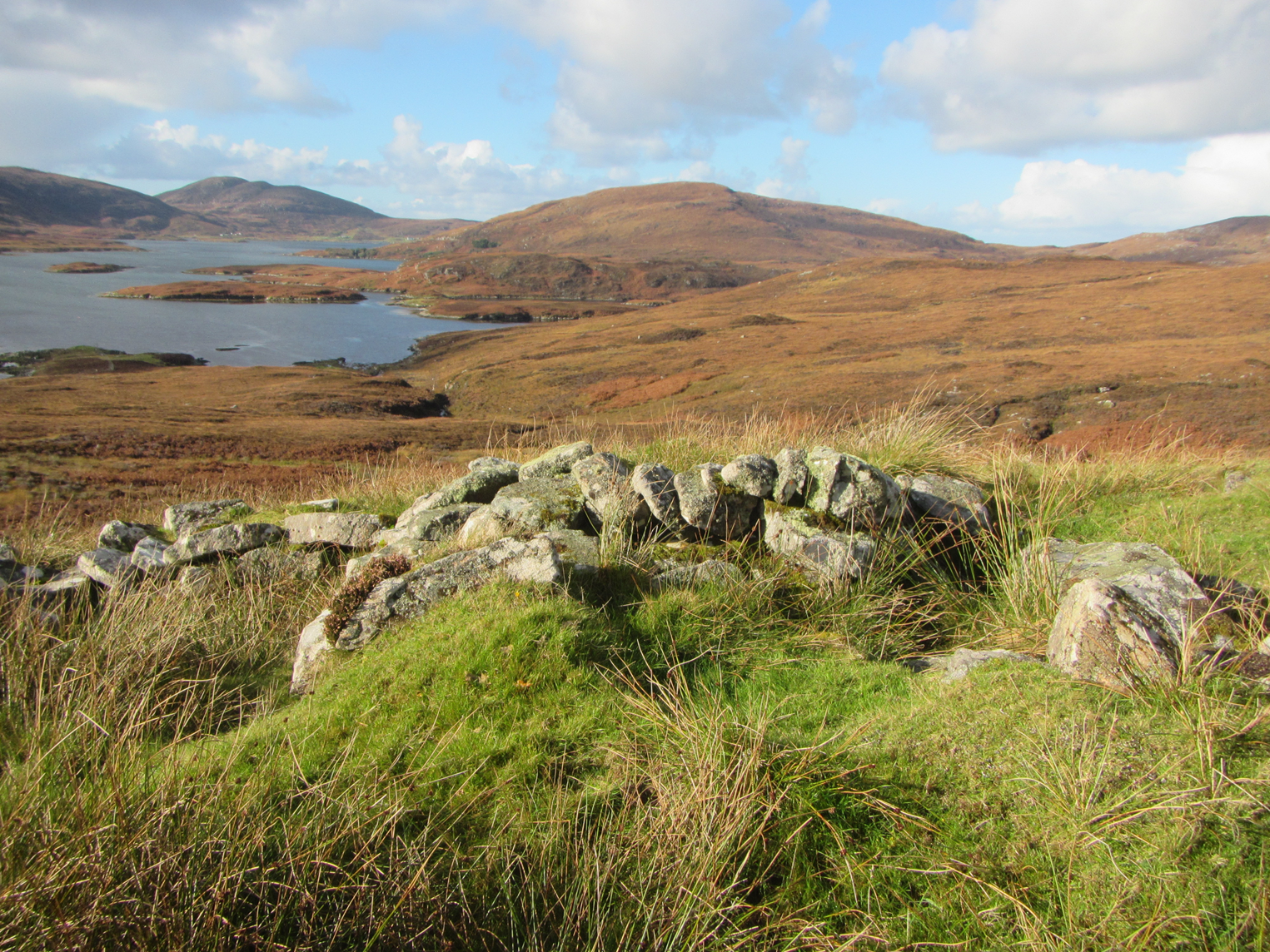
Figure 7. Shieling huts above Loch Aoineart, South Uist, looking west (photograph: Simon Davies).
On the triall or ‘big flit’ up to the shielings of South Uist, Carmichael records the men carrying ‘sticks, heather-ropes, spades, and other things needed to repair their summer huts’, and the women carrying ‘bedding, meal, dairy and cooking utensils’ (Carmichael, Reference Carmichael and Napier1884: 469–70). Small recesses in the walls held ‘the various utensils in use by the people’ (Carmichael, Reference Carmichael and Napier1884: 472). With a typical interior space of 2 × 2.5 m, there was little room in the shieling huts of central South Uist for more than sleeping, cooking, and eating, and then only when it could not be done outdoors (Figure 8). Separate structures often held the dairy equipment (Raven, Reference Raven, Parker Pearson, Sharples and Symonds2012: 166). Excavation of eight shieling huts on Ben Lawers in Perthshire produced a significant but relatively limited range of material culture: pottery; glass fragments, including bottles; horseshoes; a probable nail; scissors; assorted metal fragments; and some rough stone discs that may have been cheese-weights (Atkinson et al., Reference Atkinson, Dalglish, Dixon, Donnelly, Harrison and Lelong2016: 221–57).

Figure 8. Woman milking a cow beside a shieling, perhaps in the Western Isles in the early twentieth century. Reproduced by permission of High Life Highland and Am Baile (Am Baile image no. 38752).
What is striking here is how closely integrated the shielings are into a wide range of economic and social activities beyond herding and dairying. The Ben Lawers survey noted a strong correlation between shielings and peat moors, with tracks leading above the head dyke, which delimited the arable areas, to the platforms used for drying the peat after cutting in May (Boyle, Reference Boyle and Govan2003: 27–28). In Ireland, there are good examples of shielings being associated with peat cutting and perhaps iron mining (Costello, Reference Costello2018: 176–77). Like shielings, illicit whisky distilling was closely integrated with the lowland or lochside settlement: one such distilling site, for example, was hidden below a waterfall in a small gorge only 20 minutes’ walk from the settlement of Rowardennan on Loch Lomond, and just a couple of minutes’ walk from the main path to the settlement's shielings (Given, Reference Given2004: 156–60).
Back in South Uist, poetry and oral history give numerous examples of other activities carried out at the shielings, for example supporting the important domestic weaving industry by gathering roots, lichens and plants for dyes, and fishing and hunting for wildfowl (Raven, Reference Raven, Parker Pearson, Sharples and Symonds2012: 163; Smith, Reference Smith, Parker Pearson, Sharples and Symonds2012: 396). To characterize all this as ‘summer pastoralism’ would be highly reductionist.
There are, of course, complexities and tensions to this integration. Costello points out that while the pasturing and dairy work, carried out primarily by young women, gave them considerable freedom, many other activities, such as digging peat and metal-working, were considered male tasks, giving opportunities for continuing surveillance and control of relationships (Costello, Reference Costello2018). Many of the same communal relationships moved up to the shielings, though they were looser and in spatial terms more extended than in the lowland settlement. Either way, the key issue is the richness and variety of social life generated by the interaction between people, livestock, plants, places, and seasons. Human and non-human interdependence enriches social relations, rather than reduces them.
Conclusions: Attending Time and Place
Today, in our global quest for homogeneity, we have expelled seasonality through central heating and air-conditioning, waterproof clothing and sunglasses, cheap flights, and endless tarmac. Consequently, we struggle to see past seasonality as anything more than a hopelessly romanticized rural idyll, or an insipid annual round, with people reduced to automata repeating the same weary circuit every year.
What is striking in many different recent studies of seasonality is the plurality, versatility, and flexibility offered by complex human–non-human relationships that interact with the opportunities and challenges of the changing seasons (e.g. Milner, Reference Milner, Milner and Woodman2005: 58; Burri, Reference Burri2014: 29–30; Costello, Reference Costello2018: 166; Overton, Reference Overton and Pilaar Birch2018). In areas of high topographic diversity, a key feature that enables much of this variability is the transect (cross-section) perpendicular to the contours of slope, rainfall, and temperature. By encompassing many topographical, ecological, and social zones over a short distance, this transect gives huge opportunities for improving productivity, increasing the range of interaction among humans and between humans and others, and keeping all these relationships responsive and fluid.
Two very different situations in early modern Cyprus and Scotland have demonstrated that, despite this variety, there is close integration of practices across the landscape and the seasons, with continuous (and continually changing) connections and interactions. Shielings, satellite settlements, and wintertowns are not ‘sites’ of a particular ‘type’ with a narrow economic function, but operational processes whose ramifications and connections spread across a ‘relational continuum’ of time and space (Conneller, Reference Conneller, Milner and Woodman2005: 47; Wright, Reference Wright2012: 97).
For humans, there are two ways of enabling these spatial and temporal processes. The first is mobility. Only by incorporating regular, ongoing movement into their daily lives can people make all these fluid and changing connections up and down the gradient and across social and ecological zones. Dwelling, in this sense, can only be carried out ‘on the move’ (Sheller & Urry, Reference Sheller and Urry2006; Aldred, Reference Aldred2012: 499). These movements are examples of Edgeworth's ‘land flows’, where activity and relationships happen in the ‘spaces in between’ what we used to call ‘sites’ (Edgeworth, Reference Edgeworth2011: 107, 110). Archaeologically, this requires a careful analysis not just of the structures and nodes but of the paths, routes, topography, animal behaviour, and, above all, the fluidities and interdependencies that connect them (Walsh & Mocci, Reference Walsh and Mocci2011: 89–91; Aldred, Reference Aldred and Pilaar Birch2018; Overton, Reference Overton and Pilaar Birch2018). Relations and power do not sit anywhere: they move, flow, change, emerge.
The second is attentiveness. Seasonality demands a close awareness of, response to, and negotiation with the changing attributes and affordances of plants, weather, soil, water, animals, and, of course, those other animals called humans. This attentiveness enables a recognition of interdependence: for example, a farmer or herder depends on the vagaries of when the hill grass or grain reaches maturity, or on whether a boggy moorland will supply sufficient grazing for a herd of cows. As archaeologists trying to be similarly attentive, from the perspective of our later periods and radically different societies, we focus on botanical and zoological remains, artefacts, geomorphology, ruined structures, spatial distributions, and, where we have them, human memories and documents. But there is a correspondence, or perhaps an interaction, between the attentiveness of past farmers and herders and that of ourselves. Life in a seasonal world can only be lived, and interpreted, by attending to place and time.
Acknowledgements
The Troodos Archaeological and Environmental Survey Project was supported by the Arts and Humanities Research Council under grant number RG/4164/14633. The Strathearn Environs and Royal Forteviot project was supported by Historic Environment Scotland under grant number 53552. I am very grateful to all colleagues, students, and local residents who participated in and assisted the Strathearn Environs and Royal Forteviot Upland Survey and the Troodos Archaeological and Environmental Survey Project. Particular thanks are due to the villagers in Cyprus who gave us so many valuable insights into Mandres and other aspects of rural society, especially Kostas Benaki and Michael Ppantjiaris, and to Simon Davies for his information and photographs of shielings in South Uist. I am grateful to the Leventis Museum, Nicosia, for permission to publish Figure 1 (left), to Batsford/Pavilion Books for Figure 1 (right), and to High Life Highland and Am Baile for Figure 8. The very helpful comments of Eugene Costello, Kevin Grant, and two anonymous reviewers have greatly improved this article.


