Introduction
The term ‘bog bodies’ has been in use since the 1870s for the often well-preserved human remains found in peat bogs across northern Europe (van der Sanden, Reference van der Sanden1996, Reference van der Sanden, Menotti and O'Sullivan2013). The conditions of their burial environment can support the preservation of soft tissues that are not normally preserved on archaeological sites (Brothwell & Gill-Robinson, Reference Brothwell, Gill-Robinson, Haglund and Sorg2002). This results in significant opportunities for acquiring detailed information about the lives and deaths of the individuals. Consequently, most of the work on bog bodies has focused on forensics, leading to substantial knowledge gain. However, the study of their landscape context constitutes a hitherto unexploited potential for increasing our knowledge of bog bodies and their depositional history. Most studies are site-based and fail to incorporate detailed assessments of the environmental setting of the finds, with regard to both the ‘physical’ and ‘cultural’ landscape (Chapman, Reference Chapman2015). Moreover, no attempt has been made to produce best practice guidelines. These are significant problems: the vast spatial and temporal scales over which the burial practice appeared clearly show that detailed contextual assessments are of the utmost importance for our explanatory frameworks. A new, more standardized approach is important for three reasons: (1) to ensure future discoveries are adequately investigated; (2) to facilitate and optimize the re-analysis of known findspots and; (3) to make it possible to compare deposition sites across time and space.
In this article, we develop best practice guidelines for the contextual analysis of bog bodies, achieved in three steps. We first analyse the current state of research, which provides insights into methods that have been successfully applied so far and highlights significant research deficits that need to be tackled. We then present three recent case studies that illustrate the potential of a landscape-based approach. They include some of the best-known bog bodies of Europe, including Lindow Man in the United Kingdom, Tollund Man and Elling Woman in Denmark, and Yde Girl in the Netherlands (Figure 1). The results feed into the best practice guidelines that we propose here. Three spatial and temporal scales are distinguished and linked to specific research questions and methods, which we hope will form practical guidelines for future fieldwork and analysis.
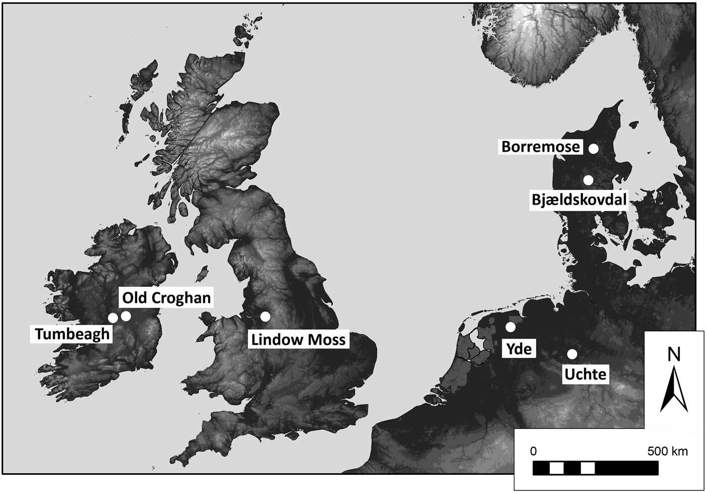
Figure 1. Locations of the principal sites mentioned in the text including the three case studies.
Current State of Research
The significant interest in European bog bodies stems largely from the often exceptional levels of preservation that includes soft tissue, hair, and skin, alongside internal organs and stomach contents. Such preservation provides extraordinary potential for the study of the forensic aspects of these individuals. For many bodies, the ability to identify injuries that would not normally be visible on the skeleton gives a tantalizing glimpse into their final moments. Many ‘early’ bog body finds have been lost due to a variety of factors (Cowie et al., Reference Cowie, Pickin and Wallace2011), and consequently most attention has been paid to discoveries made since the late nineteenth and early twentieth centuries. Some of these ‘old’ finds have recently been re-examined (e.g. van der Plicht et al., Reference van der Plicht, van der Sanden, Aerts and Streurman2004; Gill-Robinson, Reference Gill-Robinson2005; Asingh & Lynnerup, Reference Asingh and Lynnerup2007). In some regions, peat cutting has long ceased, and no finds have been made in decades (e.g. in the Netherlands: van Beek et al., Reference van Beek, Maas and van den Berg2015). In others, there have been new discoveries in recent years, most notably in Ireland (e.g. Kelly, Reference Kelly2006, Reference Kelly and Ralph2012), but also in Germany (Bauerochse et al., Reference Bauerochse, Haßmann, Püschel and Schultz2018).
Extensive research on the landscape settings of bog bodies, defined for our purposes as including both the environmental and cultural contexts at the time of deposition, has been limited. A small number of multidisciplinary studies, with their own specific aims and methods, has focused on the palaeoenvironmental analysis of individual sites. Good examples are those of Old Croghan (Plunkett et al., Reference Plunkett, Whitehouse, Hall, Charman, Blaauw and Kelly2009) and Tumbeagh, both in Co. Offaly in Ireland (Bermingham & Delaney, Reference Bermingham and Delaney2006), and Uchte in lower Saxony in Germany (Bauerochse et al., Reference Bauerochse, Haßmann, Püschel and Schultz2018). In general, these site-based studies incorporate the detailed analysis of multiple environmental proxies, such as pollen, plant macrofossils, testate amoebae, and beetles to characterize the depositional site of bodies in the context of broader processes of landscape change. Additionally, Andreas Bauerochse and Andreas Niemuth (Reference Bauerochse and Niemuth2012) developed a 3D landscape model of the Großes Moor at Uchte (Germany), whereas Henry Chapman (Reference Chapman2015) modelled archival data relating to Lindow Moss (United Kingdom). Jes Martens (Reference Martens1994) published an overview of the Iron Age stronghold of Borremose (Denmark), using mainly archaeological data. The latter comprises a concise overview of the wider cultural landscape setting, with several bogs rich in archaeological finds, including at least three bog bodies and the well-known Gundestrup cauldron (Figure 2). Recently, Christina Fredengren (Reference Fredengren2018) has also used multiple datasets to analyse the deposition of bog bodies in Sweden.
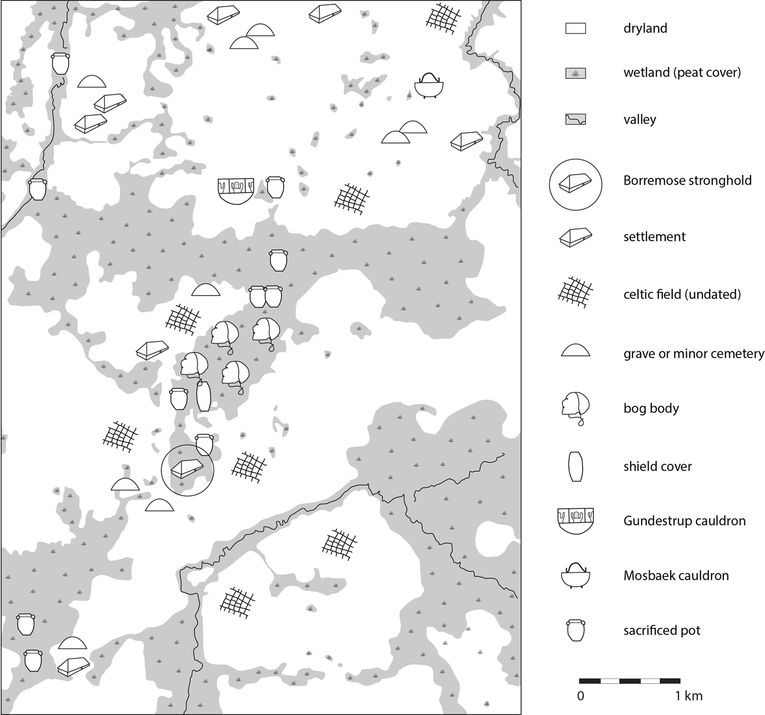
Figure 2. Cultural landscape of the Borremose region (Denmark) in the Iron Age. The indicated wetland areas at this time, mostly consisting of peatlands, are mainly derived from modern-day geomorphological and elevation data. Redrawn after Martens, Reference Martens1994: 267, fig. 19, with permission of the author.
Besides the site-based publications mentioned above, various regional overviews of bog body sites are available (e.g. van der Sanden, Reference van der Sanden1996; Hesse et al., Reference Hesse, Grefen-Peters, Peek, Rech and Schliemann2010; Ravn, Reference Ravn2010, Reference Ravn and Boyle2011; Burmeister, Reference Burmeister and Müller-Scheeßel2013). These start from an archaeological perspective and share a focus on the history of the discoveries, forensics, and explanatory models. Occasionally, some information is given on the landscape setting. Stefan Burmeister (Reference Burmeister and Müller-Scheeßel2013), notably, examined the distribution of bog bodies across northern Europe in relation to a number of factors, including the size of the bogs in which the bodies were found and their position in relation to the bog edges. Morten Ravn (Reference Ravn and Boyle2011) stressed the importance of incorporating data on contemporaneous settlements and cemeteries, but unfortunately did not put this into practice. One specific observation made in relation to the landscape setting of bog bodies, particularly in Denmark, is that some of them were probably placed in earlier peat cuttings (e.g. Asingh, Reference Asingh, Asingh and Lynnerup2007; Fischer, Reference Fischer2012).
The detailed site-based studies discussed above mark a modest shift in research into bog body sites, with the importance of palaeoenvironmental analyses recognized, not only in terms of establishing the environmental context but also highlighting the contribution these data can make to aspects of cultural interpretation (see Gearey & Chapman, Reference Gearey and Chapman2004). Nevertheless, there are significant methodological and theoretical problems that still need to be addressed. Most of the work so far has been limited in scope, both spatially and/or chronologically. Many studies focus on what can be defined as the local level, that is, the findspot itself and its immediate vicinity. This probably stems from the fact that bog bodies are often perceived as more or less exceptional phenomena (e.g. Glob, Reference Glob1969) and hence are studied in their own right. Arguably, another aspect is that the context of discovery may be implicitly viewed as providing little information aside from being a ‘wet bog’. Yet, as we shall see, bog landscapes vary between and within sites with respect to vegetation, relative surface wetness, etc.
The chronological focus of many studies is generally on the ‘deposition’ event itself instead of the potential of longer-term perspectives offered by the character of the landscape and change within it derived from palaeoenvironmental evidence, although information from these data may be implicit in certain interpretative frameworks (e.g. Kelly, Reference Kelly2006, see below). It is indeed important to realize that these finds, like all archaeological material, can only be understood in a larger social, spatial, and chronological context. Gaining detailed insights into diachronic palaeoenvironmental changes can lead to a better understanding of the deposition sites, especially the interplay between peatland dynamics, specifically palaeohydrological fluctuations which may be related to climatic changes, as Kelly (Reference Kelly2006) shows in his interpretation of later prehistoric Irish bog bodies. Hydrological data derived from testate amoebae analyses have allowed Gearey and Caseldine (Reference Gearey and Caseldine2006) to argue that patterns of prehistoric activity, as reflected in the construction of sites on the peatland, were closely related to shifts in surface wetness. There is no corresponding information for recent later prehistoric Irish bog body finds other than Old Croghan Man (Plunkett et al., Reference Plunkett, Whitehouse, Hall, Charman, Blaauw and Kelly2009). Human land-use patterns derived from pollen analyses also potentially contribute to these discussions, although we encounter theoretical as well as methodological issues when linking archaeological ‘events’ such as the deposition of a body to less chronologically ‘exact’ palaeoenvironmental events such as changes in land-use.
When considering the socio-cultural context of the bog body practice, it should be realized that various types of wetlands, among them peatlands, were recurrently used for deliberate deposition of carefully selected objects. While there is considerable variation in the ways in which such practices were enacted at different sites, for many, these practices were conducted in ‘natural’ places for millennia, an aspect that indicates the importance of these areas for (pre)historic communities (e.g. Bradley, Reference Bradley2000). The selective deposition of objects (see Needham, Reference Needham1988; Fontijn, Reference Fontijn2002) had motives often regarded as ‘ritual’, as frequently suggested for the bog body phenomenon. However, variations in the details relating to bog bodies highlight the risk of conflating the use of the term for both their description and interpretation. Clearly, there is a need for greater levels of contextual information. Hence, any attempt at interpretation should incorporate a thorough analysis of the patterns of wetland deposition within the context of other archaeological material (Becker, Reference Becker2013) and broader contemporary social and cultural patterns. In this respect, it is striking that few detailed site distribution maps are available depicting the findspots of bog bodies, settlements, cemeteries, field systems, and other cultural phenomena, the Borremose region being one of the very few exceptions (Figure 2). It is clear that singling out bog bodies as a specific find category is misleading, and that making distinctions between wetlands (serving ‘ritual’ purposes) and drylands (‘profane’ use) is not useful if we want to contextualize both environmentally and culturally, and understand past deposition practices. We are dealing with traditions that, at least in their appearance, share similarities over millennia and across vast areas. However, there are also clear differences between sites, and we need to anticipate that underlying motives and meanings may have been diverse and dynamic. This makes contextual analyses even more important. To illustrate this, we present three recent case studies that highlight the potential of a landscape-based approach to the study of bog bodies.
Case Studies
Lindow Moss (United Kingdom)
Lindow Moss is a peatland in Cheshire where four discoveries relating to probably two or three (partial) bog bodies have been made. The first, a cranium found in 1983 (Lindow I; Brothwell, Reference Brothwell, Stead, Bourke and Brothwell1986), was followed by the excavation of a body in 1984 (Lindow II; Turner, Reference Turner, Stead, Bourke and Brothwell1986). Subsequent discoveries of body parts were made in 1987 (Lindow III, near Lindow I) and 1988 (Lindow IV, probably associated with Lindow II; Turner, Reference Turner, Turner and Scaife1995). The analysis of the most complete body, Lindow II (more commonly known as Lindow Man), revealed a complex set of injuries resulting in his death, including blows to the head, garrotting, and a slit throat (West, Reference West, Stead, Bourke and Brothwell1986). At the time of discovery, samples for palaeoenvironmental analysis were taken from the findspot. Their analysis led to the conclusion that Lindow II was deposited in a pool of water (Buckland, Reference Buckland, Turner and Scaife1995), the bog having become wetter shortly before deposition (Barber, Reference Barber, Turner and Scaife1995). No wider assessment of the landscape context was undertaken at the time of discovery but in the 1990s a borehole survey across Lindow Moss provided stratigraphic data (Leah et al., Reference Leah, Wells, Appleby and Huckerby1997).
Chapman (Reference Chapman2015) modelled the data collected in the 1990s to reconstruct the landscape at the time of deposition. He concluded that the locations of the depositions were close to the very centre of the peatland in the Iron Age. Coupled with the earlier suggestion that the landscape was becoming wetter at the time, it is likely that the area had become increasingly inaccessible and that the deposition of the bodies required significant effort. A subsequent programme of gridded borehole excavation across the whole of Lindow Moss confirmed this interpretation, and has identified areas of peat near the location where Lindow II was discovered that may include contemporaneous and more recent deposits (Figure 3).
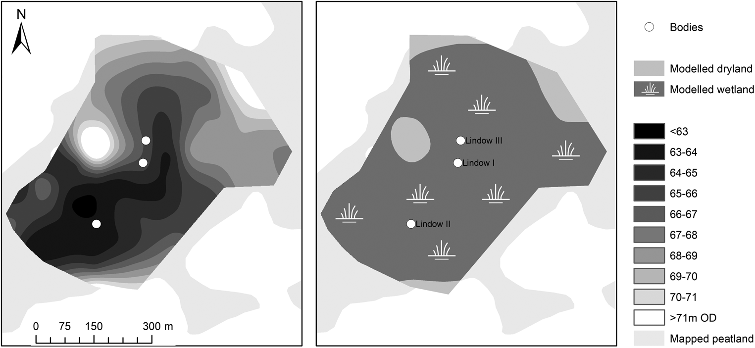
Figure 3. Lindow Moss, Cheshire (UK), showing the locations of the three bog body finds. Left: topography of the pre-peat land surface; Right: extrapolated extents of wetland at the time of deposition of the Lindow II body.
Pollen analysis demonstrated that the wider landscape around Lindow Moss was subject to increased woodland clearance throughout the Iron Age and into the Romano-British period. The data indicate an expansion of human activity indicators, such as Plantago lanceolata, and open pastoral environments (Birks, Reference Birks1965; Oldfield et al., Reference Oldfield, Higgitt, Richardson, Yates, Stead, Bourke and Brothwell1986; Branch & Scaife, Reference Branch, Scaife, Turner and Scaife1995). They are the strongest indication of human activity in the area around Lindow Moss, whereas the archaeological evidence within the locality is relatively slim. Finds from the bog itself include earlier Bronze Age artefacts (Cheshire HER1472/0/0) and a Bos jawbone (Cheshire HER1472/0/1), in addition to anecdotal reference to an undated trackway structure on its south-western side (Cheshire HER1472/0/2; Norbury, Reference Norbury1884).Footnote 1 Prehistoric copper mines are found on Alderley Ridge, approximately 3k m to the south-east of the site. Evidence for wider later prehistoric activity centres on the Mid Cheshire Ridge to the south-west, including a cluster of hillforts. However, these are likely to have been abandoned by the time of Lindow II's deposition.
The wetland context of the Lindow bodies might emphasize the relative inaccessibility of the findspots. In contrast, the wider dryland landscape consisted of largely treeless agricultural land. These data can be variously interpreted. For example, if the contemporary mire surface was very wet, it is likely that the people responsible for the deposition had intimate knowledge of the local environment. The apparent lack of archaeological structures close to the findspots confirms that access must have been on foot without the benefit of a trackway. The character of the wider cultural landscape is more difficult to establish in terms of the distribution of archaeological sites with respect to the vegetation, although the evidence for an increasingly open grassland with possible indicators of pastoral farming suggests a largely domesticated locale. Other aspects include the fact that an open landscape has implications in terms of visibility from the dryland, potentially significant for any observers or audiences to the killing and deposition of Lindow Man.
Bjældskovdal (Denmark)
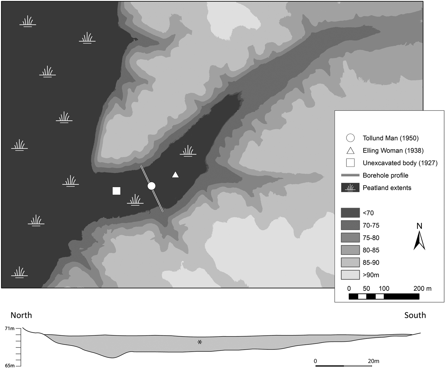
Bjældskovdal is a valley wetland on the eastern edge of what is now Bølling Lake in central Jutland, where three bodies have been found in close proximity. The first discovery was of a body in 1927, but it was unfortunately not recovered from the bog (van der Sanden, Reference van der Sanden1996). The discoveries of Elling Woman in 1938 and Tollund Man in 1950 followed. These two bodies had clearly been hanged, and the careful excavation of the well-preserved Tollund Man showed that he had afterwards been gently placed in the bog in a sleeping position with his eyes and mouth closed. Stratigraphic observations at the find locations of Tollund Man and Elling Woman indicated that these bodies had been placed in old peat cuttings, which also agrees with the findings of prehistoric wooden spades close to the two bog bodies at approximately the same find depth (Fischer, Reference Fischer2012).
In 2017, a new field project was started by the University of Birmingham in collaboration with Museum Silkeborg. Its aim is to reconstruct the topography of the sandy, pre-peat land surface and to establish the potential for the survival of organic deposits. Forty-seven boreholes were excavated, aligned in three transects across Bjældskovdal, encompassing the approximate findspots of Tollund Man and Elling Woman. During the borehole survey, a maximum depth of 1.55 m of peat was identified within the boreholes, the average being less than 0.5 m. However, it is known that peat cutting in the first half of the twentieth century removed a 2–4 m-thick peat layer from practically the entire surface of Bjældskovdal. The profiles revealed a relatively flat-bottomed valley with a narrow channel on its northern side that deepened towards the west.
Establishing the three-dimensional position of the bodies in relation to these profiles is problematic for two reasons. First, the archival data is incomplete and, in some cases, contradictory. Second, the positioning within ancient peat cuttings means that calculating the likely elevation range of the peatland surface requires some calibration. For Elling Woman, contemporary reports indicate that her head lay approximately 36 cm from the sandy base of the peat. The skin wrapping was just 15 cm above the base of the bog, 60 cm to the south (reproduced in Fischer, Reference Fischer2012: 84). Absolute basal elevations within the potential area of the findspot of Elling Woman (based on Fischer, Reference Fischer1980) range between 67.35 m and 68.43 m asl. Therefore, it is likely that the position of the body was around 68 m asl. For Tollund Man, establishing the likely elevation of the body is more difficult. Estimates calculated from notes by Jørgen Troels-Smith in 1952 (National Museum Archive Number A4020) in relation to the adjacent peat section indicate an elevation for the body of between 68.40 and 69.50 m asl. Currently, only Tollund Man has been re-dated using the newest methods (405–380 cal bc); but, based on current knowledge, it appears that Elling Woman was deposited in Bjældskovdal slightly later (200 years later at most; Nielsen et al., Reference Nielsen, Philippsen, Kanstrup and Olsen2018). Because of the general contemporaneity of the two bog bodies, one might assume that the lower elevation is more likely, although the possibility for variations in bog surface elevation from ancient peat cuttings should be taken into account. Stratigraphic indications suggest such cuttings to be 40 cm deep, and it seems that the maximum elevation of the bog surface at the time was about 70 m asl.
The elevation of the bodies in relation to the bog surface level, combined with their horizontal positioning, provides the potential to explore factors such as accessibility and distance from the bog edge at the time of deposition (Figure 4). The horizontal positioning of Tollund Man can be calculated from archival data from the environmental work of Troels-Smith (Reference Troels-Smith1952), placing Tollund Man towards the centre of the peatland. If the surface of the bog was at around 70 m elevation, the full width of the bog would be 130 m. This would require travel across the bog from the nearest dryland over 65 m from either side. If the surface of the bog had been at 68 m elevation (corresponding with the minimum surface elevation of the peat cutting containing the body of Elling Woman) then the total width of the bog would have been considerably narrower at 70 m. Due to the shape of the valley floor, a difference in elevation of just 2 m has a dramatic impact on the accessibility of the bog.

Figure 4. Bjældskovdal (Denmark), showing the positions of the three bog body finds and extrapolated extents of wetland at the time of deposition of Tollund Man (plan and profile).
Roughly contemporary finds from the area of the bog include several wooden spades, of which two were found a few metres from Tollund Man, and one close to Elling Woman. Two parallel rows of Quercus stakes, probably the remains of a corduroy trackway, were also discovered. Unfortunately, the precise position of this structure is not known, but they crossed the bog with stakes positioned approximately every metre, with a little less than 2 m between the two rows. Radiocarbon dating of the only preserved stake indicates that the trackway was constructed around 793–486 bc (95.4 per cent confidence interval; recalibration on the average of 2500 ± 40 bp as reported in van der Plicht et al. (Reference van der Plicht, van der Sanden, Aerts and Streurman2004), with OxCAL v.4.3.2 (Bronk Ramsey, Reference Bronk Ramsey2009) using the IntCal13 calibration curve (Reimer et al., Reference Reimer, Bard, Bayliss, Beck, Blackwell and Bronk Ramsey2013)). While this one stake pre-dates the bodies, the trackway may still have been in use when the bodies were placed in the bog. No Early Iron Age settlement, graves, or field systems have been found close enough to Bjældskovdal to suggest a direct link with the bog bodies, but human activity in the broader region at this time is well attested.
It is clear that the location chosen for the deposition of Tollund Man (and probably the other bodies) was in the centre of the bog, broadly equidistant from the dryland to the north and south. It is uncertain what the hydrological status of the bog was at the time (in terms of surface wetness) and the relationship between this and Iron Age peat cutting, or the context in terms of wider chronological and spatial patterns of environmental change is also uncertain. Regardless, the profile of the bog indicates that any increased wetness would have resulted in considerable lateral spread. Ongoing archive studies and analyses of samples taken from a surviving peat baulk may provide more insight into the environmental and landscape context of the three bog bodies.
Yde Girl (the Netherlands)
Yde Girl gained worldwide recognition when her face was reconstructed at Manchester University in 1992 (van der Sanden, Reference van der Sanden1994). She was found in 1897 by two labourers in a small bog south of the village of Yde (van der Sanden, Reference van der Sanden1990: 81–83). The bog body surfaced when the labourers were extracting peat using dredging poles, at a depth of approximately one metre. The remains belong to an approximately 16-year old girl with long hair, the right half of which was probably cut off. She was dressed in a heavily-worn woollen cloak. A braided woollen cord with a sliding knot around her neck was probably used to strangle her. A series of AMS 14C dates of samples from hair, cloak, and cord (van der Plicht et al., Reference van der Plicht, van der Sanden, Aerts and Streurman2004: 486–87), which have been recalibrated for the present study, place her death between 42 cal bc and cal ad 59 (95.4 per cent confidence interval).
The site was reconstructed in the 1990s by a combination of written documents, cartographic evidence, and oral history (van der Sanden, Reference van der Sanden1990, Reference van der Sanden1994). Late nineteenth-century topographic maps show various T-shaped and right-angled peat reclamation pits scattered over a large heath area. There has been some debate as to the exact findspot, but the most likely site is the north-easternmost reclamation pit. Since the late 1920s, the area was gradually turned into agricultural land. In the 1970s, the pit was filled in with sand and a field ditch was dug through its centre, the site being subsequently used as arable land. The location is still clearly visible as a wet depression. In 1995, students of Groningen University conducted a small-scale field survey by means of borehole excavation, and a palynological analysis was carried out (Bandel et al., Reference Bandel, Brennan, Halice, van der Meulen, Nicolay and Rooke1995; Bottema, Reference Bottema1995). The data indicated the depression to be 1.8 m deep at the maximum, with Late Glacial or Early Holocene peat in the lower part of the profile.
In 2017–2018, the Yde site was re-investigated by an interdisciplinary team from Wageningen University and Research Centre in order to reconstruct the physical and cultural landscape context at the time of deposition (van Beek et al., Reference van Beek, Candel, Quik, Bos, Gouw-Bouman and Makaske2019). The analysis centred on the site itself and its wider environment, the latter consisting of a study area of 14 × 11 km around the findspot. The study comprised physical geographical, palaeoecological, and archaeological components. The geographical elements consisted of the creation of an up-to-date geomorphological map of the wider study area, combined with a ground penetrating radar (GPR) survey and coring at the findspot. The palaeoecological investigation focused on reconstructing the vegetation in the wider study area, based on a detailed inventory of existing palynological data in and near the area under study. The archaeological component centred on reconstructing the cultural landscape in the later Iron Age and early Roman period by compiling a thorough inventory of archaeological sites (Figure 5).
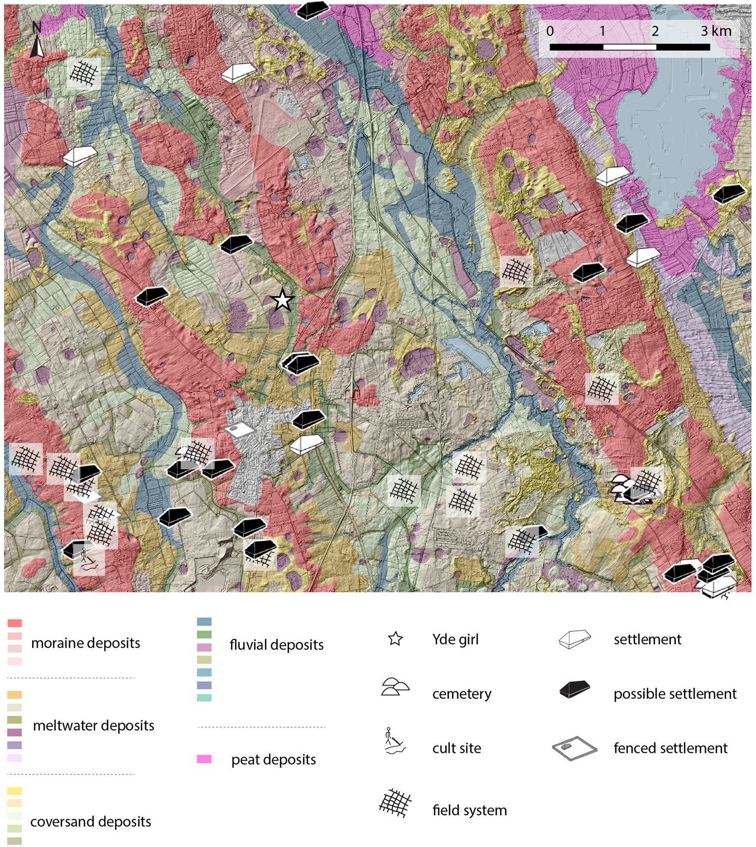
Figure 5. Cultural landscape of the Yde macro region during the Late Iron Age/Early Roman period (250 bc to ad 100). Geomorphological map by Gilbert Maas (Wageningen Environmental Research) and Bart Makaske (Wageningen University & Research Centre).
Results of the study demonstrate that Yde Girl was probably deposited in a small, wet depression (possibly a pingo remnant) with a diameter of approximately 30–40 m and a depth of about 2 m. This small bog lay within a relatively heterogeneous landscape dominated by a series of moraine ridges, most importantly the large Hondsrug ridge about 3 km to the east, and low-lying plains and valleys in between. The vegetation was relatively open, of mosaic character, consisting of heathland, relict forest, arable fields, and pasture, and was heavily influenced by human activity. The landscape was dotted with small hamlets consisting of a few farmsteads, cemeteries, ‘Celtic’ field systems, and other deposition sites. These show that the findspot was by no means remote or isolated, but very much part of an anthropogenic landscape.
Compared to the work on Lindow and Bjældskovdal, the methodology applied in the recent Yde case study stands out for its interdisciplinary approach and combination of different spatial research scales. The most detailed new knowledge was gained from the reconstruction of the cultural landscape in the wider study area, enabled by the availability of a large archaeological dataset in combination with an inventory of extant palynological evidence. The Yde region is a typical example of a Dutch reclamation landscape, heavily affected by humans. Even though the Yde findspot itself no longer contains significant peat remains, there are various pingo scars scattered over the wider area that probably contain better-preserved sediments and may form targets for additional future palaeoenvironmental analysis.
Proposed Methodology
Based on our assessment of previous work and the experiences gained during the recent and ongoing projects in the United Kingdom, Denmark and the Netherlands, best practice guidelines can be proposed for future research on the environmental and cultural context of European bog bodies. Central to this is the realization that different research questions need to be answered on different spatial and chronological scales, using bespoke methodologies that draw from cultural and scientific approaches (Table 1). We suggest the following as a ‘best case’ framework that can be tailored for particular situations. Raising awareness of where within the research framework the investigation is positioned (including possibilities to expand) would be extremely valuable. For working purposes, we define context in terms of archaeology and palaeoenvironment, although we recognize that these categories are interrelated. Similarly, we identify three nested scales (spatial and chronological) relative to the findspot: micro-, meso-, and macro-scale (see Table 1 and Figure 6). The relationship between these scales is not unproblematic or linear (see below); aspects of each scalar component might be adopted depending on factors such as previous research. We are aware that not every study can work on all scales and use all proposed methods, as all contexts are different and available resources vary.
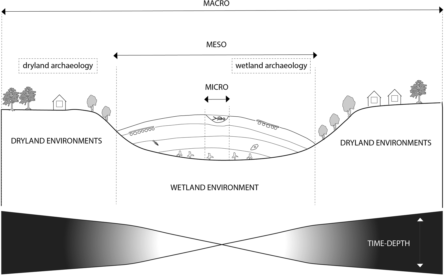
Figure 6. Schematic representation of the different spatial research scales to be included in future bog body research, and how they relate to the different temporal scales in terms of time depth.
Table 1. The three spatial and temporal scales to be included in future bog body research, and the ways in which they relate to themes of interpretation.

Micro-scale resolution
The micro-scale can be defined as restricted to the immediate find location, measured in terms of a few square metres (e.g. the original investigations of Lindow Man) around the position of the body. This should be regarded as the very minimum scale of analysis for in situ finds, providing local contextual data only. The critical aspect is determining the character of this depositional environment (e.g. pool, peat cutting), the development of the associated bog surface across time scales (minimum 10 years) in relationship to the age of the body and any associated archaeological finds. For most bog bodies where palaeoenvironmental analyses have taken place, it is generally at this resolution that the work was conducted. For some sites, the surviving deposits directly associated with the bodies will be missing, although adjacent deposits (e.g. at Lindow Moss) provide the potential for detailed analysis. Bermingham and Delaney (Reference Bermingham and Delaney2006) describe an exemplary approach to the excavation and sampling of the Lemanaghan Bog Body (Tumbeagh, Co. Offaly in Ireland), building on the approach developed for Lindow Man (Turner, Reference Turner, Stead, Bourke and Brothwell1986) and allowing optimal sampling, excavation, and analyses on the micro-scale. The strategy developed by Bermingham and Delaney (Reference Bermingham and Delaney2006) included the establishment of ‘buffer zones’ around the remains exposed on the cut-over surface of the peatland, followed by cleaning the area around the body (270 m2 in total), concentrating on the direction in which peat cutting machinery tended to move material. The excavation of small circular test pits (0.10 m diameter, 0.30 m deep) around the exposed body allowed the extent of the remains to be better defined, leading to the isolation of a block of peat containing the surviving body (1.2 m × 0.6 × 0.5 m), which was lifted, packed, and excavated in the laboratory. Excavation of in situ remains in laboratory conditions must be regarded as a key aim, permitting understanding of the microstratigraphy of the peat in relation to the human remains. Direct lifting of remains should be avoided if possible, as this is very likely to result in the loss of potentially crucial stratigraphic data as well as excluding the possibilities of sub-sampling peat samples in intimate association with the body.
From a palaeoenvironmental perspective, the focus should be on understanding the immediate depositional environment of the body, including the nature of the contemporaneous bog surface and that associated with the depth of the remains. Such data can be gathered in part stratigraphically from excavations (where possible), as well as adjacent sections (e.g. drain faces) if available, and from boreholes. In order to understand the local environmental context, a range of palaeoenvironmental analyses will generally be required. As a minimum, this should include plant macrofossils, beetles, and potentially other proxies, specifically testate amoebae to determine the wetness of the bog surface, in the case of ombrotrophic peat deposits. Other relevant analyses might include determining the ash content of the peat (Bermingham & Delaney, Reference Bermingham and Delaney2006: 38). It is important that sampling strategies be developed in advance of excavation, in consultation with the relevant specialists. Different proxies require specific practical approaches; sampling for microfossils would usually be facilitated via monolith sampling, while bulk samples for beetles and plant macrofossils require the development of a bespoke strategy derived from an understanding of the particular stratigraphic context of the body. The key point is the development of an integrated approach to palaeoenvironmental analyses and sampling at the earliest opportunity and preferably the presence of the relevant specialists during excavation.
Understanding the bog surface, derived from stratigraphy and the palaeoenvironmental proxies, has particular implications for factors such as the burial environment (which can be compared with forensic evidence for deposition) and the ease or difficulty of movement at the location itself. Given observations, particularly in Denmark, of bodies being placed in peat cuttings, there is considerable potential for discrepancies between the dates of the bodies and the dates of the underlying peat surface. Exposed sections can provide context, but in their absence a gridded borehole survey will be required to assess the stratigraphic context of the local area, potentially with additional palaeoenvironmental analyses and radiocarbon dating. The possibility that deposition could relate to contemporary environmental change, such as increased bog surface wetness, highlights the need to undertake detailed, high-resolution analysis of palaeoenvironmental samples contemporary with, and directly pre-dating, the body.
Detailed analysis of archaeological observations related to the body and findspot, including forensics (evidence of peri- and post-mortem impacts) and associated finds, give insights into the context of the find and the preservation conditions of the body compared with stratigraphy. Best practice should include block lifting of the remains if possible, allowing detailed excavation in the laboratory (see Bermingham & Delaney, Reference Bermingham and Delaney2006). At the very least, a survey of the immediate area of the find for further archaeological remains and recovery of samples, if appropriate, should be undertaken.
The chronological programme must establish the age of the body itself, taking into account the issues around establishing a reliable date for previous bog bodies. Single radiocarbon determinations are probably insufficient. In terms of the palaeoenvironmental sequences, the radiocarbon programme should be sufficiently nuanced to construct a chronology of the stratigraphic and biostratigraphic changes established by the fieldwork and palaeoenvironmental programmes. Multiple dates and analyses of multiple peat fractions (Chapman & Gearey, Reference Chapman and Gearey2013) may be necessary to ensure a robust chronology and to investigate any discrepancies between the date of the body and its associated context (see the Lindow Man debate: Barber, Reference Barber, Turner and Scaife1995; Buckland, Reference Buckland, Turner and Scaife1995).
Meso-scale resolution
Challenges and opportunities at the meso-scale, within the wider locality of the findspot (i.e. within a radius of 10–100 m), are slightly different. In previous research, this scale of investigation is perhaps the most under-studied. The purpose of using this spatial scale is to establish the location of the body within the context of the peatland system. This, for example, includes the identification of pools, wetter/drier areas, drainage channels, or ancient peat cuttings. In addition to broadening the spatial resolution of analysis, it should expand the chronological focus to the scale of hundreds of years to facilitate the interpretation of landscape changes over multiple generations (and also reflect the precision of many of the dates obtained for bog bodies).
In order to achieve this, a detailed stratigraphic analysis of these areas of the bog is needed. Where appropriate this can be combined with geophysical methods (e.g. GPR) to establish the shape of the pre-peat topography (see Chapman & Gearey, Reference Chapman and Gearey2013) and provide data for the modelling of stratigraphic layers within the bog. There remain challenges in identifying waterlogged archaeology within peatlands by geophysics due to a lack of physical contrasts (e.g. Clarke et al., Reference Clarke, Utsi and Utsi1999) and a variety of different techniques have been applied to address this (e.g. Schleifer et al., Reference Schleifer, Weller, Schneider and Junge2002). However, it has been noted that GPR has the greatest potential for these environments, with some success in identifying in situ sites (Armstrong et al., Reference Armstrong, Cheetham and Darvill2018), but that this is dependent on chemistry and peat preservation. Remote sensing provides the possibility of obtaining continuous stratigraphic data across a bog, and this can be validated through borehole stratigraphic analysis.
Dates for the onset of wetland growth from basal deposits across the bog can give evidence of its chronological development, in addition to providing indications, through modelling, of the processes that influenced its formation (see Chapman & Gearey, Reference Chapman and Gearey2013). Establishing the palaeohydrological status of the peatland, through testate amoebae, plant macrofossils, and techniques such as humification analyses, is of particular relevance at this scale. These data are significant for assessing the relative wetness of the peatland at the time of body deposition, but also for identifying any longer-term fluctuations in hydrology, including at or just before the event in question. Kelly (Reference Kelly2006) has hypothesized that later prehistoric Irish bog body killings may relate to sacrificial rituals following episodes of crop failure potentially associated with climatic deterioration. In theory, such palaeoenvironmental ‘events’ can be identified from pollen and palaeohydrological proxies. Although demonstrating a causal link with the deposition of a body is theoretically and methodologically challenging, close resolution sampling and the construction of robust archaeological and palaeoenvironmental chronologies is the only way to test these hypotheses.
Through such analysis, coupled with palaeoenvironmental study, it is possible to determine differences in the bog surface at different times as this has implications for factors such as movement within and across the wetland. Furthermore, this can also provide information relating to the distance from the bog edge at the time of the body deposition.
Other archaeological finds and structures from the locality of the body can give an indication of cultural activity, whether contemporary with the body or relating to earlier or later activity, such as trackways, platforms, or artefacts. For example, the trackway on Bjældskovdal bog provides evidence that the bog was being used in the centuries before the deposition of the bodies, and might relate to activities such as peat cutting. The contemporaneity of these features in relation to the bodies, as well as the purpose of such activities, whether for fuel or bog-ore, can also provide valuable data for interpretation. Alongside the potential for further finds, fieldwork should also include systematic survey of the bog surface and ditches.
Macro-scale resolution
Macro-scale analysis aims to understand bogs and the bodies found in them within a broader context, including the relationships between dryland and wetland. From a palaeoenvironmental perspective, the intention is to understand the development and diachronic extents of the entire peatland within its wider landscape context, including vegetation patterns across the adjacent dryland. In order to achieve this, wider borehole surveys, possibly in association with GPR survey, are required to establish the shape of the entire pre-peat land surface as well as peat stratigraphy through time. In order to reconstruct large-scale vegetation patterns and understand wider environmental factors and processes across time, the analysis of samples should include pollen, beetles, and tephra, in addition to other proxies. The wider geomorphological landscape provides a context for this through various types of datasets including those obtained by LiDAR. In many regions, basic geomorphological and geological maps will already be available, which may be augmented by additional fieldwork.
In tandem with palaeoenvironmental analyses, the archaeological record should be integrated within the study. In order to assess the position of the body site in relation to contemporary cultural activity, it is important to reconstruct the character of the cultural landscape at the time of deposition. In well-investigated regions this can be done by making inventories of known sites, in combination with new excavation and survey, as appropriate. Aerial photography, LiDAR, and other remote sensing methods may provide additional data on land-use patterns. For later (medieval and post medieval) bog bodies, historical sources, place names, folklore, and even oral accounts may be a valuable source of additional evidence (Kama, Reference Kama2016). Equally, the detailed perusal of antiquarian records may provide additional information relating to less well-known finds from these landscapes (e.g. Cowie et al., Reference Cowie, Pickin and Wallace2011).
Analysing wider patterns of cultural continuity or change can produce information on societal changes which may provide significant information on the underlying motives of the deposition practices. Both in Yde and Borremose, the bog bodies are contemporary with the emergence and use of extremely rare types of walled enclosures, for example, and some form of relation between both is worthy of consideration. Equally, such patterns can be compared with factors such as environmental change to establish potential chronological and spatial relationships between the two. Hence, the investigation of bogs at this macro-scale facilitates an extension of the research agenda beyond the different approaches typically used on either wetland or dryland sites; it has the potential to integrate and understand longer-term trends in the cultural and environmental records within the vicinity of bog landscapes.
Discussion
The best practice guidelines proposed provide a new framework for the study of European bog bodies which aims to ensure that future discoveries are adequately investigated, and facilitates and optimizes the re-analysis of previous discoveries. Ultimately, by using the scalar approach outlined here, it should enable different sites to be compared more explicitly. So far, most work on the landscape setting of bog bodies has been undertaken in Ireland, the United Kingdom, Denmark, and Germany. Most attention has been paid to finds dated to the Iron Age and Roman period, the medieval find of Tumbeagh in Ireland (Bermingham & Delaney, Reference Bermingham and Delaney2006) being a notable exception. The discussion would greatly benefit from including sites from other regions (e.g. north-eastern Europe) and periods.
Not every future study will be able to encompass all scales and use all proposed methodologies. To a degree, we anticipate a mix of data collection methods based on the site location, condition, etc.: finds situated in landscapes that are heavily affected by peat cutting and other reclamation are, as in the past, likely to form the greater part of future discoveries. Cut-over peatlands may offer limited possibilities for palaeoenvironmental study, but survey of such contexts may reveal surviving areas of contemporaneous deposits, even if those at the findspot have been disturbed or removed. For many bogs across north-western Europe, peat cutting has reduced, with many sites being restored as sites of nature conservation. While new discoveries are likely to emerge through active peat milling where it is still taking place, shifts in land-use, such as re-watering, may offer new opportunities but also new challenges.
Detailed insights in archaeological site distribution patterns and, therefore, in the cultural landscape before, during, and after the time of deposition of a bog body will usually be available. The site of Yde in the Netherlands is a clear example. For new discoveries in areas where peat is still being cut, this cultural landscape context may be more difficult to reconstruct but these sites offer great chances for state-of-the-art palaeoenvironmental research as demonstrated at Old Croghan in Ireland (Plunkett et al., Reference Plunkett, Whitehouse, Hall, Charman, Blaauw and Kelly2009) and Uchte in Germany (Bauerochse et al., Reference Bauerochse, Haßmann, Püschel and Schultz2018). However, the remaining organic resource is finite and threatened, and so there is a significant need to act quickly in order to maximize the information available.
Many research deficits signalled in this article do not only apply to bog bodies, but also to other types of archaeological finds from peatlands. These problems may partly stem from a deep-rooted distinction between wetland and dryland archaeology. Additionally, as mentioned by Brück (Reference Brück1999), archaeologists have the tendency to distinguish ‘ritual’ from ‘secular’ action. This leads to a misapprehension of prehistoric rationality; both are likely to have been extensively interwoven, as bog bodies being placed into peat cuttings perhaps indicate. It is important to break down the forced boundaries between the ritual and the profane, between wetland and dryland, and between scientific and cultural archaeologies to move the discussion forward, and the best practices defined here may be one of the steps contributing to that process.
Conclusions
This article has highlighted the challenges and opportunities offered through a new approach to the study of European bog bodies. We argue that the landscape context of the body constitutes an approach that may significantly improve our understanding of the individuals represented and the themes and variations within the bog body phenomenon. By assessing the current state of research and combining it with the experiences gained in three recent case studies, this article proposes guidelines for best practice. Three spatial and temporal scales are distinguished and linked to specific research scales and methods. This provides a framework for the investigation of future discoveries, facilitates and optimizes the re-analysis of known findspots, and enables the comparison of deposition sites across time and space. It is of critical importance that such a methodology is applied to bogs before the surviving, often very fragmentary, peat resource is lost.
Acknowledgements
Roy van Beek worked on this article within the framework of the Home Turf Project of Wageningen University and Research Centre, financed by the Dutch Organisation for Scientific Research (NWO Vidi Project, no. 276-60-003). The authors would like to thank Dr Jes Martens (University of Oslo) for permission to reproduce Figure 2 and for knowledge exchange on Danish sites, and Dr Andreas Bauerochse (Lower Saxony State Office for Cultural Heritage) who provided information on his work on the Uchter Moor.