


Introduction
More than half of the world’s natural wetlands have been lost as a consequence of rapid economic development during the last century (Kar Reference Kar2013, Chen et al. Reference Chen, Dong, Xiao, Zhang, Tian, Zhou, Li and Ma2016). Remaining wetlands are undergoing extensive degradation due to increasing human activities (Butchart et al. Reference Butchart, Walpole, Collen, Van Strien, Scharlemann, Almond, Baillie, Bomhard, Brown and Bruno2010, Wang et al. Reference Wang, Fraser and Chen2017). China is no exception particularly as, since 1990, a third of its natural wetlands has disappeared (An et al. Reference An, Li, Guan, Zhou, Wang, Deng, Zhi, Liu, Xu and Fang2007, Cyranoski Reference Cyranoski2009). Wetland loss and degradation have negatively affected wetland-dependent wildlife, among which waterbirds are one of the most conspicuous and threatened species groups. As a consequence, global declines in many waterbird populations have been detected, and remaining populations are under various threats (Butchart et al. Reference Butchart, Walpole, Collen, Van Strien, Scharlemann, Almond, Baillie, Bomhard, Brown and Bruno2010, Wang et al. Reference Wang, Fraser and Chen2017).
Due to the declining carrying capacity of remaining natural wetlands, waterbirds have been increasingly found to use created wetlands as alternative habitats, such as paddy fields, aquaculture ponds and water reservoirs (Petchey et al. Reference Petchey, Evans, Fishburn and Gaston2007, Navedo et al. Reference Navedo, Masero, Sanchez-Guzman, Abad-Gomez, Gutierrez, Sanson, Villegas, Costillo, Corbacho and Moran2012, Elphick Reference Elphick2015). Bird use of these man-made wetlands and the associated threats they are facing have become hot topics of conservation. Some researchers suggest that these created wetlands could serve as a cost-effective alternative to natural wetland conservation (Longoni Reference Longoni2010, Li et al. Reference Li, Chen, Lloyd, Zhu, Shan and Zhang2013). Critics argue that waterbirds using created wetlands are threatened by more intensive human disturbances and emphasize the higher habitat quality of natural wetlands over created wetlands (Tourenq et al. Reference Tourenq, Bennetts, Kowalski, Vialet, Lucchesi, Kayser and Isenmann2001, Ma et al. Reference Ma, Li, Zhao, Jing, Tang and Chen2004). No matter which side is correct, the created wetlands have attracted a wide array of waterbird species. Particular attention in research and conservation should be paid to these waterbirds in human-dominated wetlands because they are highly sensitive to short-term political and/or economy-driven decisions. The habitat compensation role of paddy fields and aquaculture ponds for waterbirds has recently also been recognized in China (Wood et al. Reference Wood, Qiao, Li, Ding, Lu and Xi2010, Li et al. Reference Li, Chen, Lloyd, Zhu, Shan and Zhang2013). However, little attention has been given to the large-area and expanding subsidence wetlands created by massive and continuing underground coal mining.
China is rich in coal resources, which account for 69% of its own total energy consumption (Bian et al. Reference Bian, Inyang, Daniels, Otto and Struthers2010). Coal production in 2015 was 3.75 billion tonnes, approximately 50% of the worldwide total, and is predicted to increase for the foreseeable future (Dong et al. Reference Dong, Samsonov, Yin, Yao and Xu2015). Along with its prominent role in promoting China’s economic development, coal mining has led to a series of geological and environmental problems, such as cropland losses, landscape damage and pollution of air, water and soil (Dong et al. Reference Dong, Samsonov, Yin, Yao and Xu2015). Among others, extensive land subsidence and submergence have occurred in coal-mining areas, significantly changing regional landscapes. As of 2011, the total mining subsidence area has reached 1×10⁶ ha in China, with an annual increase of 7×10⁴ ha (Hu et al. Reference Hu, Yang, Xiao, Li, Yang and Yu2014b). Due to high groundwater levels and abundant rainfall, large areas of subsiding grounds have been flooded in the North China Plain, where four of the 14 largest coal production bases are located. Land subsidence induced by underground coal mining is an unintended source of wetland development (Hu et al. Reference Hu, Yang, Xiao, Li, Yang and Yu2014b, Lewin et al. Reference Lewin, Spyra, Krodkiewska and Strzelec2015). This process is not unique to China, and the resulting wetlands have been found to harbour a variety of wetland flora and fauna in other regions (Nawrot et al. Reference Nawrot, Kirk and Elliott-Smith2003, Townsend et al. Reference Townsend, Helmers, Kingdon, McNeil, de Beurs and Eshleman2009, Lewin et al. Reference Lewin, Spyra, Krodkiewska and Strzelec2015). In the context of natural wetland loss and degradation, these subsidence wetlands may attract large numbers of waterbirds to rest, forage or nest. Avian use of these created wetlands and potential influencing factors should be quantified in order to better understand the contribution of these wetlands to waterbirds, as well as their conservation values.
Bird use of wetlands is strongly associated with complex biotic and abiotic factors, and their responses to heterogeneous environments are species specific due to differences in habitat selections (Pearman Reference Pearman2002, Barbaro et al. Reference Barbaro, Rossi, Vetillard, Nezan and Jactel2007). Moreover, selection processes are simultaneously influenced by factors that operate over a variety of spatiotemporal scales and interact with anthropogenic factors (Pearman Reference Pearman2002, Martin & Blackburn Reference Martin and Blackburn2012). Identifying multiscale variables influencing the habitat use of waterbirds is challenging but important for waterbird conservation in created wetlands. Meanwhile, waterbirds play an important role in the ecosystem services provided by wetlands and are often recognized as bio-indicators of environmental changes (Mistry et al. Reference Mistry, Berardi and Simpson2008, Whelan et al. Reference Whelan, Şekercioğlu and Wenny2015). Therefore, it is a pressing need to explore the bird–environment relationships and structuring factors of the waterbird assemblages in the large-area subsidence wetlands. In developing countries such as China, however, conservation efforts are focused on biodiversity in established protected areas, such as nature reserves and national parks, rather than created wetlands (Xu et al. Reference Xu, Xiao, Zhang, Yang, Zhang, Hull, Wang, Zheng, Liu and Polasky2017, Zhang et al. Reference Zhang, Luo, Mallon, Li and Jiang2017). No study has been conducted to investigate avian use of the subsidence wetlands, posing a large barrier for formulating effective management plans.
Here, we carried out a systematic study to quantify waterbird community structures in subsidence wetlands in the North China Plain and to explore the effects of multiscale environmental and anthropogenic variables. We tested the expectations that these created wetlands provide complementary habitats for a wide array of waterbird species and that avian use of these wetlands is determined by factors at multiple scales. We used direct multivariate analyses combined with variance partitioning methods to disentangle the independent and joint effects of habitat variables on the waterbird communities. Our results provide primary information about the waterbird assemblage structures and the bird–environment relationships and have important implications for management purposes in these large, expanding, created wetlands.
Methods
Study Area
We conducted the study in the Huainan–Huaibei coal-mining area (32°44’–33°44’N, 116°02’–117°31’E; Supplementary Fig. S1, available online) located in the south of the North China Plain, which encompasses an area of 3×10⁷ ha. A flat and occasionally undulating topography characterizes the agricultural landscape in this region. The elevation averages approximately 30 m above sea level, with some low knolls up to 300 m. It has a typical warm, temperate, semi-humid, monsoon climate, with an average annual temperature of 14.7 °C and an average annual precipitation of 970 mm, with the majority of rain falling between April and August. The area is adjacent to the north of the Huai River, and the natural wetland system is mainly composed of lakes and rivers in the floodplain, with an estimated area of 8.7×05 ha (Xu et al. Reference Xu, Wan, Sheng, Wen, Xu and An2013).
The Huainan–Huaibei coal-mining area is dominated by croplands with forest remnants scattered in an agricultural matrix. The plain is one of the 14 largest coal bases in China, with an area of 1.5×10⁶ ha producing 4.2% of the national output (Hu et al. Reference Hu, Yang, Xiao, Li, Yang and Yu2014b). There has been coal extraction from these underground areas for more than 100 years. This massive coal mining has resulted in extensive ground deformation and subsidence. Until 2010, the subsidence area exceeded 3×10⁴ ha with an annual expansion of more than 2×10³ ha. Half of these lands have been waterlogged, with an average water depth of 3–6 m, because of high groundwater levels and abundant rainfall (Xie et al. Reference Xie, Zhang, Yi and Yan2013). These subsidence wetlands were created in different years and differ in a wide range of attributes. The environmental heterogeneity allows us to explore the effects of numerous habitat variables on waterbird community structures.
Bird Counts
We conducted waterbird surveys in 55 subsidence wetlands patchily distributed across the Huainan–Huaibei coal-mining area (Supplementary Fig. S1). The total area of sampled wetlands was 6226 ha, which is approximately 40% of all flooded subsidence lands. These randomly selected wetlands represented the heterogeneity of the study area in terms of local and landscape variables. Depending on the area and the accessibility of each wetland, one to six counting points were strategically placed along its shore for an unobstructed view of the wetland. The observation radius at any point was shorter than 1 km with no overlaps to avoid double-counting.
Field waterbird surveys were undertaken on clear and calm days every 2 weeks from September 2016 to April 2017. During each survey, the same two skilled bird observers visited all fixed counting points and used the ‘look-see’ counting method to record all waterbirds using these wetlands, including those flushing from within their boundaries (Delany Reference Delany2005). Waterbirds were identified to the species level with the help of binoculars (10×42 WB Swarovski) and a telescope (20–60× zoom Swarovski: ATM 80) during 15 minutes at each counting point. We followed the taxonomy of the International Ornithological Congress (IOC) World Bird List (Mouchet et al. Reference Mouchet, Villeger, Mason and Mouillot2010) and defined waterbirds as species of birds that are ‘ecologically dependent upon wetlands’ according to the Ramsar Convention (Gardner & Davidson Reference Gardner and Davidson2011). Vega gull (Larus vegae) and Caspian gull (Larus cachinnans) were grouped into European herring gull (Larus argentatus) due to difficulties in identification. According to similarity in resource sharing and exploitation techniques (Blondel Reference Blondel2003), we grouped waterbirds into six guilds: diving birds (grebes and cormorants); ducks (Anatidae); large waders (herons, egrets and spoonbills); vegetation gleaners (jacanas and gallinules); gulls; and shorebirds (Charadriidae and Scolopacidae; Supplementary Table S1).
Habitat Variables
Thornton et al. (Reference Thornton, Branch and Sunquist2011) showed that species responses to habitat variables in a spatially heterogeneous landscape should be studied at multiple scales. We quantified 11 environmental and anthropogenic factors that potentially affect habitat use of waterbirds in each independent subsidence wetland at both local and landscape scales. These attributes were categorized into four groups: local structural; landscape structural; wetland age; and anthropogenic (Table 1). We define a ‘landscape’ for each wetland as the 5-km buffer zone surrounding its edge. Wetland age referred to the time (years) since wetland creation, determined by comparing Landsat images (Thematic Mapper [TM]/Enhanced Thematic Mapper [ETM]/Operational Land Imager [OLI]) acquired every 16 days from 1987 to 2016. Distance to roads and human settlements, area of aquaculture enclosures and number of discarded houses (human buildings abandoned in place after land subsidence) in each wetland were determined with the assistance of field surveys and high-resolution Google Earth maps. Other variables were calculated based on the land-cover map (see below). The matrix of environmental variables was standardized prior to it being used in ordination analyses.
Table 1 Habitat variables considered as potential predictors of waterbird community structures in subsidence wetlands in the Huainan–Huaibei coal-mining area in China

To obtain a land-cover map of the study area, we used a remotely sensed image acquired on 2 September 2016 (Level 1T of Landsat 8 OLI on path 122/row 37) with no cloud cover downloaded from the US Geological Survey website (http://glovis.usgs.gov). The image had been radiometrically and geometrically (systematically) corrected using observatory ephemeris data and ground control points (NASA Landsat Program 2016). It was re-projected onto the Universal Transverse Mercator Projection 1984 coordinate system, zone 50 (north). We conducted a supervised classification on the image using a maximum likelihood classifier in ENVI 5.1 (Exelis VIS, Inc.). Five land-cover categories were identified: cropland; developed land; open water; aquatic vegetation; and woodlands. Two hundred representative samples for each land-cover type were visited and classified during field surveys or with the assistance of Google Earth maps. Half of these samples were randomly selected to be used as training data and the remaining half were used to validate the classification. The overall accuracy was 94.4% and the κ coefficient was 0.91, indicating high classification accuracy. We did not identify mudflats in the classification because there were only a few narrow strips of this habitat type along the interior boundaries of only a few wetlands, and they could not be identified in the remotely sensed image.
Statistical Analyses
According to the migration chronology of waterbirds, we divided the study duration into three periods: autumn migration (September to November 2016); wintering season (December 2016 to mid-February 2017); and spring migration (late February to April 2017). During each period, there were four surveys, each covering all of the 55 wetlands. We pooled bird abundance in each guild during each period and over the entire study. Therefore, we had four guilds×sites matrices, one in each period. There were no significant changes in habitat variables during field surveys, and thus the same variables×sites matrix was used in further analyses.
We used a constrained ordination method to directly estimate variations of the waterbird communities and explained the variations with associated habitat variables. We first conducted exploratory analyses on the guild matrix using a detrended correspondence analysis (DCA) to determine whether a linear or unimodal ordination method would be appropriate for further analyses. The length of the first DCA axis during each period was less than three standard deviations, indicating relatively homogeneous guild datasets. We therefore used a linear response model – a redundancy analysis (RDA), as suggested by Lepš and Šmilauer (Reference Lepš and Šmilauer2003) – to ordinate the waterbird communities together with the habitat attributes. In the RDA procedure, multivariate linear regression analyses and principal component analyses were combined to model multivariate response data (e.g., a guild matrix) with environmental variables as constrained axes. The four guild matrices were transformed by Hellinger transformation to allow usage of RDA with datasets containing extreme values (Legendre & Gallagher Reference Legendre and Gallagher2001). Forward selection was used to select explanatory variables with significant effects on the waterbird community structures. Variables added in the RDA model were in order of their additional contributions to the total variation. Monte Carlo tests with 9999 permutations were applied to evaluate the significance of variables and only those with p-values less than 0.05 were included in the final models. Variation partitioning was applied using the adjusted R 2 in RDA to disentangle the pure and joint contributions of selected variables to the variation in response data (Heikkinen et al. Reference Heikkinen, Luoto, Virkkala and Rainio2004, Legendre et al. Reference Legendre, Borcard and Peres-Neto2005). As the method can only partition variation in community data with maximally up to four explanatory factors (or groups of explanatory factors), variable groups (Table 1), rather than each independent variable, were considered in the partitioning procedure. All statistical analyses were performed using the package ‘vegan’ 2.4.3 in R 3.4.1.
Results
Habitat Variables
Ages of the sampled wetlands ranged from 1.8 to 28.0 years, and sizes ranged from 7.8 to 970.4 ha. Their shape index ranged from 1.1 to 2.4, representing increasing irregularity from a circle. Open water and aquatic vegetation were two major habitat types within wetlands, accounting for 59.7% (±21.2% SD) and 24.0% (±15.1%) of the wetland area, respectively. Other land-cover types within wetland boundaries, taken together, occupied on average only 16.3% of the area. Within the 5-km buffer zone surrounding each wetland, total area of wetlands (open water and aquatic vegetation; >1 ha) averaged 1574.5 (±1245.0) ha, accounting for 15.7% (±11.4%) of the buffer area. There were discarded houses inside 42 wetlands and the density ranged from 0 to 1.5 per ha with a mean of 0.2 (±0.3). Aquaculture was widespread across the wetlands, and the proportion of open water area covered by aquaculture enclosure ranged from 0% to 6.1% with a mean of 0.5% (±1.3%). Distances to roads and human settlements ranged from 0 to no farther than 4 km, and means were both shorter than 1 km. Total settlements area (developed lands; >10 ha) within the 5-km buffer zone averaged 1965.5 (±1272.4) ha, accounting for 19.9% (±11.5%) of the buffer area (Table 1).
Waterbird Community
In total, we recorded 89 349 waterbirds of 60 species belonging to 13 families and 7 orders during the 2016–2017 migration and wintering season (Supplementary Table S1). More than 90% of the species were long-distance migrants of the East Asian–Australasian Flyway. Over the study period, 45 species were recorded in more than six wetlands (11%) and seven species in more than 44 wetlands (80%). Vegetation gleaners were the dominant guild, and the Eurasian coot (Fulica atra) was the most abundant species. The four most abundant species (Eurasian coot, Eurasian teal [Anas crecca], mallard [Anas platyrhynchos] and little grebe [Tachybaptus ruficollis]), taken together, represented 62.5% of all the birds. Each of the remaining species individually accounted for less than 5% of the total abundance. During each of the 12 counts, we recorded an average of 34 (±4) species and 7446 (±3393) individuals, with the mean bird density in each wetland ranging from 0.4±0.6 to 2.7±5.1 individuals per ha. Both species richness and bird abundance showed seasonal changes, increasing during the autumn migration, remaining steady during the wintering season and decreasing during the spring migration (Fig. 1). Seasonal fluctuations were similar for bird abundances of vegetation gleaners, ducks and diving birds, but not for large waders and shorebirds, which were more common during migrations.
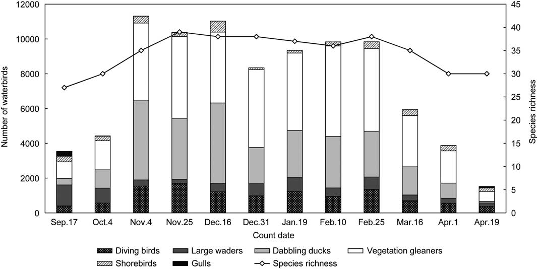
Fig. 1 Waterbird community structures and seasonal fluctuations in the 55 surveyed subsidence wetlands in the Huainan–Huaibei coal-mining area in China, with number of birds in each guild (bars) and total species richness (line).
Among the recorded species, six were categorized as globally threatened or near-threatened species on the International Union for Conservation of Nature (IUCN) Red List: Baer’s pochard (Aythya baeri) (critically endangered [CR]), swan goose (Anser cygnoides) (vulnerable [VU]), common pochard (Aythya ferina) (VU), falcated duck (Mareca falcata) (nearly threatented [NT]), ferruginous duck (Aythya nyroca) (NT) and northern lapwing (Vanellus vanellus) (NT).
Correlation between Waterbird Guilds and Habitat Variables
Six variables had significant effects (Monte Carlo tests) in one or more of the final RDA models (Table 2). Proportions of total variance explained by the selected variables were relatively low, ranging from 16.4% to 26.7% in different periods. Variables (p<0.05) included in the models differed between periods, with the number of variables ranging from two to four. Distance to human settlements (DH) was included in all the four models for all periods. Area of surrounding wetlands (WE) and distance to road (DR) affected the waterbird communities only during the autumn migration, whereas wetland age (AG), area of open water (AO) and shape index (SW) were more important in other periods. Several variables were never significant in RDA models: these were two local structural variables, area of aquatic vegetation (AA) and wetland perimeter (PW), and three anthropogenic ones, density of discarded houses (HD), area of aquacultural activities (PE) and surrounding total area with settlements (SA).
Table 2 Selected variables in the final redundancy analysis (RDA) models and proportion of total variance explained regarding waterbird communities in different periods in subsidence wetlands in the Huainan–Huaibei coal-mining area in China. AG=wetland age; AO= area of open water; DH= distance to nearest human settlement; DR=distance to nearest road or railway; SW=shape index of wetland; WE=total area of wetlands (>1 ha) within 5-km buffer zone surrounding each wetland

The first two axes (RDA 1 and 2) together explained minimally 89.3% of the total constrained variation of the waterbird communities during each period (Table 3), and this increased to 100% in the wintering season, when only two variables were significant (DH and AO).
Table 3 Summary of redundancy analysis (RDA) models for waterbird–environment relationships in subsidence wetlands in the Huainan–Huaibei coal-mining area in China

In RDA plots with selected environmental variables, DH, AO and SW, had the longest projections (Fig. 2). Vegetation gleaners were ordinated separately from other guilds in all of the plots, parallel to the first axis. Vegetation gleaners were negatively correlated with DH, AG and AO during all of the periods. Larger waders were positively associated with WE during the autumn migration, and were positively associated with AG or AO during other periods. Shorebirds preferred wetlands far away from human settlements (DH) during all periods, indicating their low tolerance for anthropogenic disturbances. Diving birds were positively associated with WE during the autumn migration and avoided wetlands with irregular shapes (SW). Ducks selected wetlands with larger AO during the wintering season and spring migration. Projected distances from gulls to variables did not differ significantly (Fig. 2).

Fig. 2 Redundancy analysis plot of habitat variables and waterbird abundance in each guild during (a) autumn migration, (b) wintering season, (c) spring migration and (d) the entire study period. Habitat variables are represented by arrows with labels, waterbird guilds by lines with labels and wetlands by circles. A=diving birds; B=ducks; C=large waders; D=vegetation gleaners; E=gulls; F=shorebirds. AG=wetland age; AO=area of open water; DH=distance to nearest human settlement; DR=distance to nearest road or railway; SW=shape index of wetland; WE=total area of wetlands (>1 ha) within 5-km buffer zone surrounding each wetland.
Variation Partitioning
Anthropogenic variables had the largest partial effects during all periods on the waterbird assemblage structures. Local attributes had no effects during the autumn migration, but constituted the second most important group of variables during other periods. Landscape variables mainly affected waterbirds during the autumn migration, but these were not important during other periods. Wetland age had effects on waterbird communities during the spring migration and over the whole period. The pattern of variance partitioning for the whole study was similar to that of the spring migration. Joint effects were found during the autumn (2.1% for landscape and anthropogenic variables) and spring migrations (0.8% for wetland age and local variables; Fig. 3).

Fig. 3 Variation partitioning of the variance in the guild composition during (a) autumn migration, (b) wintering season, (c) spring migration and (d) the entire study period. Negative fractions or shared variations are not shown.
Discussion
A large number of migratory and resident waterbirds (60 species in total and 2.7 individuals per ha at maximum) use the subsidence wetlands created by underground coal mining in the Huainan–Huaibei coal-mining area. The assemblages covered most of the waterbird species migrating over the study area (Wang et al. Reference Wang, Fraser and Chen2017, Jia et al. Reference Jia, Wang, Zhang, Cao and Fox2018). These long-distance migratory birds rely on food resources at stopover and wintering sites to complete their migrations. However, most of the natural wetlands in adjacent regions have been lost or degraded, resulting in declines of waterbird populations (Murray & Fuller Reference Murray and Fuller2015). For example, a survey conducted in January 2016 recorded a total of 306 026 waterbirds (approximately 0.2 individuals per ha) of only 69 species in 72 natural lakes recognized as important stopover and wintering sites for waterbirds in the Huai River and Yangtze River floodplains, indicating significant declines of both species richness and abundance compared to those in 2005 (Jia et al. Reference Jia, Wang, Zhang, Cao and Fox2018). In the context of loss and degradation of natural wetlands, complementary habitats provided by created wetlands for waterbirds in this region may be of vital importance (Wood et al. Reference Wood, Qiao, Li, Ding, Lu and Xi2010, Li et al. Reference Li, Chen, Lloyd, Zhu, Shan and Zhang2013).
Nearly a third of agricultural lands in the North China Plain are overlapped with coal resources, and the widespread coal mines produce approximately 18% of the total national output (Hu et al. Reference Hu, Yang, Xiao, Li, Yang and Yu2014b). Coal is excavated from underground in this region using the longwall mining method without filling to hold up the landform above, resulting in much greater levels of mining subsidence compared to other countries (Hu et al. Reference Hu, Hu, Li and Li1997, Lechner et al. Reference Lechner, Baumgartl, Matthew and Glenn2016). It is estimated that 10 000 tonnes of raw coal production will result in c. 0.2–0.5 ha of land subsidence in this region (Bian et al. Reference Bian, Inyang, Daniels, Otto and Struthers2010). Due to the high groundwater levels and abundant rainfall, the subsided lands are waterlogged, leading to complete loss of farmland productivity and a transition from a terrestrial ecosystem to wetlands (Hu et al. Reference Hu, Hu, Li and Li1997). As predicted, land subsidence caused by underground coal mining will ultimately reach 3×10⁶ ha, and two-thirds of these lands will be waterlogged (Hu et al. Reference Hu, Xiao and Fu2014a). The resulting area of subsidence wetlands may be larger than the total area of the adjacent natural wetlands in the Huai River floodplain (8.7×10⁵ ha) (Xu et al. Reference Xu, Wan, Sheng, Wen, Xu and An2013). These unintentionally created wetlands, if effectively managed, could provide important complementary feeding and resting habitats for waterbirds, particularly for the long-distance migrants along the East Asian–Australasian Flyway.
Birds use created wetlands in many countries in addition to China (Ma et al. Reference Ma, Li, Zhao, Jing, Tang and Chen2004, Elphick Reference Elphick2015). Created wetlands resulting from human development are widely distributed and, in spite of some debate on the matter, their important role as alternative habitats for natural wetlands is being increasingly recognized (Longoni Reference Longoni2010, Li et al. Reference Li, Chen, Lloyd, Zhu, Shan and Zhang2013). However, the environments of created wetlands and their surroundings are complex, and measuring their effects on waterbirds is challenging (Ma et al. Reference Ma, Li, Zhao, Jing, Tang and Chen2004, Martin & Blackburn Reference Martin and Blackburn2012). Traditional regression models often fail to identify key factors underlying bird–environment relationships because of spatial autocorrelation and collinearity between explanatory variables (Heikkinen et al. Reference Heikkinen, Luoto, Virkkala and Rainio2004). In this study, we used constrained ordination combined with variation partitioning, which yield explicit measures of independent and joint effects of selected variables, thus offering an appealing alternative when assessing bird–environment relationships. One advantage of using variation partitioning is that collinear variables in explanatory tables do not have to be removed prior to partitioning (Peres-Neto et al. Reference Peres-Neto, Legendre, Dray and Borcard2006). This method has been increasingly used in recent years to quantify the relative importance of habitat variables on bird communities (Freemark & Kirk Reference Freemark and Kirk2001, Perez-Garcia et al. Reference Perez-Garcia, Sebastian-Gonzalez, Alexander, Sanchez-Zapata and Botella2014).
The results of ordination and variation partitioning indicated that the effects of the four selected groups of habitat variables on waterbird communities in these subsidence wetlands varied among guilds and periods. Anthropogenic factors had stronger effects than other variables during all of the periods, implying that the human dimension plays a relatively large role in structuring the avian assemblages in these created wetlands (Burton Reference Burton2007, Ma et al. Reference Ma, Cai, Li and Chen2010). Among these factors, waterbirds were relatively more sensitive to the distance from human settlements. Most guilds, except vegetation gleaners, selected wetlands relatively far away from human settlements. Vegetation gleaners (e.g., Eurasian coot and common moorhen [Gallinula chloropus]) have apparently adapted well to human disturbances (Quan et al. Reference Quan, Wen and Yang2002). As in other studies (Luna-Jorquera et al. Reference Luna-Jorquera, Fernandez and Rivadeneira2012, Yuan et al. Reference Yuan, Zeng, Liang, Li, Li, Zhang, Huang, Lai, Lu, Wu and Yu2014), variables at the local scale (habitat level) had stronger effects than landscape structural variables, which were only important during the autumn migration. The effect of wetland age indicated that some bird guilds (e.g., ducks and larger waders) selected older ponds. Area of open water and water depth in each wetland increased along with wetland age due to the continuing underground coal mining (Hu et al. Reference Hu, Yang, Xiao, Li, Yang and Yu2014b). Larger areas tend to support more birds and more species (Guadagnin et al. Reference Guadagnin, Maltchik and Fonseca2009, Sebastián-González & Green Reference Sebastián-González and Green2014). Migratory birds also become familiar with older wetlands and select them in subsequent years. However, habitat diversity may decrease with wetland age due to regressive successions of the aquatic vegetation and the increasing predominance of open water as results of human modification for aquaculture (Xie et al. Reference Xie, Zhang, Yi and Yan2013). Although 6 of the 11 studied variables had significant effects during one or more periods, the total variance of waterbird communities explained by the selected variables was relatively low (16.4–26.7%). This may be attributed to the complex environment, the habitat development over time, the snapshot nature of the bird data and unmeasured attributes with potential effects. Further research should consider more comprehensive aspects, such as water quality, spatial pattern in water depth and food abundance for different guilds.
While many studies have found that created wetlands have become important habitats for a large number of waterbird species, researchers have argued that caution regarding bird use of these created habitats is needed (Ma et al. Reference Ma, Li, Zhao, Jing, Tang and Chen2004, Levy Reference Levy2015). Created wetlands are often surrounded by human-dominated landscape and are much more susceptible to anthropogenic threats; many bird guilds are negatively associated with these conditions, whereas other guilds and species are more tolerant of relatively high levels of disturbance (e.g., Eurasian coot and common moorhen). The large-area subsidence wetlands have attracted many birds, but these foraging habitats are under various threats. First, these individual wetlands are relatively small (113.2±146.3 ha) and are characterized by a relatively high level of human disturbance. Second, the ecosystem functions of these wetlands are limited due to intensive economic activities, such as excessive aquaculture and photovoltaic power generation projects (Chen et al. Reference Chen, Liu, Jiang, Zhang, Ren, Li, Li and Shi2017). Third, water pollution, particularly the accumulation of organic pollutants and heavy metals, induced by coal waste disposal and agricultural activities occurs in many subsidence wetlands (Bian et al. Reference Bian, Dong, Lei, Leng, Mu and Wang2008, Yao et al. Reference Yao, Meng and Zhang2010). Therefore, these subsidence wetlands might act as ‘ecological traps’ for waterbirds. Although some species apparently tolerate these conditions, the created wetlands, if not well managed, might ultimately threaten many of the attracted waterbirds.
Conclusion
Subsidence wetlands in the North China Plain could provide complementary habitats for a wide range of waterbird species, particularly the long-distance migrants along the East Asian–Australasian Flyway. However, these findings might be falsely used to mask the negative ecological consequences of landscape changes caused by underground coal mining. In fact, waterbirds attracted to these subsidence wetlands are under a variety of threats that are scarcely understood. Further research should be carried out to provide detailed information for formulating effective management plans. First, comprehensive habitat quality assessment should be conducted to measure habitat suitability for different waterbird species and guilds in these subsidence wetlands. Second, it is necessary to understand the network structure of these created wetlands, the use of this network by waterbirds and the exchange of birds with adjacent natural wetlands. Third, long-term systematic research is required to capture the spatiotemporal dynamics of these wetland bird communities.
Supplementary Material
For supplementary material accompanying this paper, visit www.cambridge.org/core/journals/environmental-conservation
Supplementary material can be found online at http://dx.doi.org10.1017/S0376892918000292
Acknowledgements
We are grateful to Liugen Zheng and Chunlu Jiang for their assistance in identifying subsidence wetlands created by underground coal mining. We also acknowledge the provision of free access to Landsat imagery from the US Geological Survey.
Financial Support
The study was supported by the National Natural Science Foundation of China (31770571, 31301897) and the Natural Science Foundation of Jiangsu Province (Grant No. BK20170922).
Conflict of Interest
None.


