


INTRODUCTION
Tropical dry forests have often been highlighted as one of the most threatened ecosystems in the world (Janzen Reference Janzen and Wilson1988; Dinerstein et al. Reference Dinerstein, Olson, Graham, Webster, Primm, Bookbinder and Ledec1995; Miles et al. Reference Miles, Newton, DeFries, Ravilious, May, Blyth, Kapos and Gordon2006). The ecosystem of choice for human settlement throughout the tropics (for example Central America; Murphy & Lugo Reference Murphy and Lugo1986a), these dry forests have been fragmented, converted to pastures and croplands, and reduced to a fraction of their original extent (Murphy & Lugo Reference Murphy and Lugo1986a, Reference Murphy and Lugob, Reference Murphy, Lugo, Bullock, Mooney and Medina1995; Janzen Reference Janzen and Wilson1988; Ceballos Reference Ceballos, Bullock, Mooney and Medina1995; Maass Reference Maass, Bullock, Mooney and Medina1995). Despite this anthropogenic pressure, scientific studies of tropical dry forests are scant, trailing well behind those of their humid counterparts (Sánchez-Azofeifa et al. Reference Sánchez-Azofeifa, Quesada, Rodríguez, Nassar, Stoner, Castillo, Garvin, Zent, Calvo-Alvarado, Kalacska, Fajardo, Gamon and Cuevas-Reyes2005). What few studies there are tend to be predominantly ecological, while quantitative measurements of threats are just starting to be developed, as is an understanding of the consequences of these threats for ecosystem functioning and human well-being (Miles et al. Reference Miles, Newton, DeFries, Ravilious, May, Blyth, Kapos and Gordon2006).
Research to date on dry forests in the Neotropics reflects these global patterns. In many countries, dry forests have been the focus of ecological studies, however quantitative studies of dry forest threat status are rare. Among the most significant ecological investigations in this region are those in Mexico (Lott et al. Reference Lott, Bullock and Solis-Magallanes1987; Arriaga & León Reference Arriaga and León1989; Trejo & Dirzo Reference Trejo and Dirzo2000; González-Iturbe et al. Reference González-Iturbe, Olmsted and Tun-Dzul2002; Cairns et al. Reference Cairns, Olmsted, Granados and Argaez2003; White & Hood Reference White and Hood2004), Costa Rica (Daubenmire Reference Daubenmire1972; Janzen Reference Janzen and Wilson1988; Gillespie et al. Reference Gillespie, Grijalva and Farris2000; Stern et al. Reference Stern, Quesada and Stoner2002; Kalácska et al. Reference Kalácska, Sánchez-Azofeifa, Calvo-Alvarado, Quesada, Rivard and Janzen2004), Brazil (Sampaio Reference Sampaio, Bullock, Mooney and Medina1995; Leal et al. Reference Leal, Tabarelli and Cardoso da Silva2003), Jamaica (McLaren & McDonald Reference McLaren and McDonald2003a, Reference McLaren and McDonaldb, Reference McLaren and McDonaldc), Argentina (Grau et al. Reference Grau, Gasparri and Aide2005, Reference Grau, Gasparri and Aide2008), Puerto Rico (Lugo et al. Reference Lugo, González-Liboy, Cintrón and Dugger1978; Murphy & Lugo Reference Murphy and Lugo1986a, Reference Murphy and Lugob, Reference Murphy, Lugo, Bullock, Mooney and Medina1995), Bolivia (Killeen et al. Reference Killeen, Jardim, Mamani and Rojas1998; Kennard Reference Kennard2002), Peru (Bridgewater et al. Reference Bridgewater, Pennington, Reynel, Daza and Pennington2003) and Nicaragua (Sabogal Reference Sabogal1992). Venezuela represents a major gap in these studies: available information consists primarily of unpublished dissertations and reports, with the few scientific papers focused on ecological questions such as species composition, forest structure and phenology (Aristeguieta Reference Aristeguieta1968; Tugues Reference Tugues1983; Pietrangeli & Brandin Reference Pietrangeli and Brandin1984; González Reference González, Aguilera, Azócar and González-Jiménez2003; Fajardo et al. Reference Fajardo, González, Nassar, Lacabana, Portillo, Carrasquel and Rodríguez2005; Fajardo Reference Fajardo2007). With dry forest potentially covering perhaps half the country, but currently occupying much less than that (Fajardo et al. Reference Fajardo, González, Nassar, Lacabana, Portillo, Carrasquel and Rodríguez2005), Venezuela thus represents a pertinent opportunity to test new methods for assessing dry forest status and threats.
Such new methods for assessing ecosystem threat status are urgently needed (Nicholson et al. Reference Nicholson, Keith and Wilcove2009). During the past two decades, the global conservation community has made major advances in the quantitative assessment of threat status at the species level (Mace & Lande Reference Mace and Lande1991; IUCN [World Conservation Union] 2001), as well as the incorporation of these analyses into decision-making at the global scale (Butchart et al. Reference Butchart, Stattersfield, Bennun, Shutes, Akçakaya, Baillie, Stuart, Hilton-Taylor and Mace2004, Reference Butchart, Stattersfield, Baillie, Bennun, Stuart, Akçakaya, Hilton-Taylor and Mace2005, Reference Butchart, Akçakaya, Chanson, Baillie, Collen, Quader, Turner, Amin, Stuart and Hilton-Taylor2007). Concrete proposals to use threatened species data to define conservation priorities have also been made at national scales (Gärdenfors et al. Reference Gärdenfors, Hilton-Taylor, Mace and Rodríguez2001; Miller et al. Reference Miller, Rodríguez, Aniskowicz-Fowler, Bambaradeniya, Boles, Eaton, Gärdenfors, Keller, Molur, Walker and Pollock2006, Reference Miller, Rodríguez, Aniskowicz-Fowler, Bambaradeniya, Boles, Eaton, Gärdenfors, Keller, Molur, Walker and Pollock2007). Several efforts to systematically assess the threat status of ecosystems are in development (Benson Reference Benson2006; Reyers et al. Reference Reyers, Rouget, Jonas, Cowling, Driver, Maze and Desmet2007; Rodríguez et al. Reference Rodríguez, Balch and Rodríguez-Clark2007; Nicholson et al. Reference Nicholson, Keith and Wilcove2009), but the connection between risk assessment and the establishment of conservation priorities is still weak (Rodríguez et al. Reference Rodríguez, Balch and Rodríguez-Clark2007). However, during the IV World Conservation Congress (Barcelona, Spain, 5–14 October 2004), a motion was adopted for the ‘development, implementation and monitoring of a global standard for the assessment of ecosystem status, applicable at local, regional and global levels’, inspired by ‘the successful and widespread application of the IUCN Red List Categories and Criteria at the national, regional and global level’ (Motion CGR4.MOT024). The rich experience of the IUCN Red List of Threatened Species will thus now provide the conceptual platform for the development of Red List categories and criteria for ecosystems.
In the present paper, our aims were to employ a quantitative framework for assessing threat status to explore the links between human activities and tropical dry forests, combining analyses at the national, regional and local levels in Venezuela. In particular, we sought to assess threat status, examine its drivers, and consider policy challenges and opportunities, in order to improve knowledge of the risks and threats to dry-forest ecosystems in general, and ascertain how conservation might counteract them.
MATERIALS AND METHODS
We assessed the threat status of dry forests by applying a framework of quantitative criteria and thresholds at the national level, as well as at a variety of local scales (Rodríguez et al. Reference Rodríguez, Balch and Rodríguez-Clark2007). This framework, which is analogous to the IUCN Red List categories and criteria for species (IUCN 2001; Nicholson et al. Reference Nicholson, Keith and Wilcove2009), requires the estimation of a series of landscape attributes, namely current and past extent of the ecosystem, degree of fragmentation and/or the observed and inferred rate of change, in order to determine the appropriate risk category for the region of interest.
At the national level, a map of recent (2001) dry forest cover was generated by combining a national political map of Venezuela with a recent map of the tropical dry forests of the world (Miles et al. Reference Miles, Newton, DeFries, Ravilious, May, Blyth, Kapos and Gordon2006), based on MODIS satellite data collected in 2000–2001 at a resolution of 500 m (Hansen et al. Reference Hansen, DeFries, Townshend, Carroll, Dimiceli and Sohlberg2003) (Fig. 1). The proportion of extant forests protected was determined by overlaying the map of dry forest cover with recent maps of national parks and natural monuments (Rodríguez et al. Reference Rodríguez, Lazo, Solórzano and Rojas-Suárez2004). An estimate of the maximum potential historical extent of tropical dry forests in Venezuela was taken from Fajardo et al. (Reference Fajardo, González, Nassar, Lacabana, Portillo, Carrasquel and Rodríguez2005). Finally, dry forest threat status was assessed at the national scale by contrasting these landscape metrics with the quantitative thresholds defined in the risk assessment framework employed (Table 1).
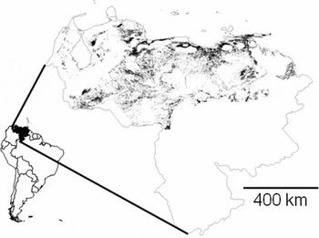
Figure 1 Current distribution of tropical dry forests in Venezuela (shaded areas). The inset shows the position of Venezuela in northern South America.
Table 1 Quantitative criteria for defining threat status categories in terrestrial ecosystems. CR = critically endangered, EN = endangered, VU = vulnerable. After Rodríguez et al. (Reference Rodríguez, Balch and Rodríguez-Clark2007).

At the regional and local scale, our risk assessments focused on a portion of northern Venezuela, where high human densities overlap with a mosaic of different forests types, large urban centres and protected areas (Fig. 2). In this c. 6500 km2 region, which comprised portions of the states of Aragua, Carabobo, Guárico, Miranda and Vargas, we analysed land cover change since the 1980s to the present, and assessed the threat status of tropical dry forests at multiple spatial scales, including the entire region, municipalities, states, major and minor watersheds, protected areas and an arbitrary grid of 10 × 10 km square cells. The area considered contains most of Venezuela's human population (Oficina Central de Estadística e Informática 1970–1997), including the cities of Valencia (capital of Carabobo), Maracay (capital of Aragua) and Caracas (the capital of Venezuela, located in Miranda). Satellite images for 1986 (Landsat Thematic Mapper) and 2001 (Landsat Enhanced Thematic Mapper) at a resolution of 30 m were processed, classified and ground-truthed using methods described in Fajardo et al. (Reference Fajardo, González, Nassar, Lacabana, Portillo, Carrasquel and Rodríguez2005). Land cover was classified as evergreen forest, semideciduous forest, deciduous forest, grasslands/burned/bare soil, cultivated areas or urban areas. The area of deciduous forest provided an estimate of dry forest extent (which was verified in the field). We used Fragstats (McGarigal et al. Reference McGarigal, Cushman, Neel and Ene2002) to quantify the number and area of dry forest fragments > 10 km2 and > 1 km apart, in both 1986 and 2001. From these data, we then estimated the proportion of the land cover converted, the rate of change and the projected land cover in 2031. The last was estimated assuming that the rate of change observed between 1986 and 2001 continued unaltered during the subsequent 30 years. This projection thus represents a future in which no policy interventions occur and the status quo continues. At these scales, threat status was once again assessed by contrasting landscape metrics with a series of quantitative thresholds (Table 1). To explore the effect of scale on conservation priorities, threat status categories were assigned to dry forest at all local spatial scales. Landscape units with > 70 % of their area located outside the boundaries of the study area were not considered in the analysis.

Figure 2 Multi-scale assessment of the extinction risk categories of tropical dry forests in northern Venezuela. The insets (left) show the relative location of our study region in Venezuela and the states that it includes (Mir = Miranda). The three protected areas in the region are shown in grey (1 = Henri Pittier National Park, 2 = Pico Codazzi Natural Monument, 3 = Macarao National Park.).
After assessing risk, we analysed threats to dry forests, again at multiple scales. Information on threats is a necessary complement to risk assessments for the definition of conservation priorities (Miller et al. Reference Miller, Rodríguez, Aniskowicz-Fowler, Bambaradeniya, Boles, Eaton, Gärdenfors, Keller, Molur, Walker and Pollock2006, Reference Miller, Rodríguez, Aniskowicz-Fowler, Bambaradeniya, Boles, Eaton, Gärdenfors, Keller, Molur, Walker and Pollock2007). At the national level, recent human uses of tropical dry forests were determined by overlaying the map of Figure 1 with an unpublished map of current land cover/land use in northern Venezuela, produced by the Government's Manejo de Recursos Naturales y Ordenamiento de Tierras (MARNOT) project. We then used a series of recent, published and unpublished national-level data sets (Ministerio del Ambiente y de los Recursos Naturales Renovables 1996; Rodríguez et al. Reference Rodríguez, Lazo, Solórzano and Rojas-Suárez2004) to develop a general picture of major human activities and protected status, both in former and present dry forest areas.
At the regional and local scales, we assessed changes by comparing the area of each land cover type (evergreen forest, semideciduous forest, deciduous forest, grasslands/burned/bare soil, cultivated areas and urban areas) from the classified satellite images of 1986 and 2001. Since our risk assessment framework focuses on changes in the different land cover types (Table 1), by identifying the land covers that replace dry forests, it is possible to infer the drivers of change. In this case, the candidate drivers were grasslands/burned/bare soil, cultivated areas and urban areas.
RESULTS
Status of Venezuelan tropical dry forests
In 2001 in Venezuela, tropical dry forests at a national scale covered c. 59 000 km2 (Fig. 1, ‘recent distribution’). Approximately 97% of remnant patches were < 1000 ha, and c. 88% of all patches were located within 2 km of their nearest neighbour (Fig. 3). The maximum historical extent of tropical dry forests in Venezuela is c. 400 000 km2 (Fajardo et al. Reference Fajardo, González, Nassar, Lacabana, Portillo, Carrasquel and Rodríguez2005). This implies that by 2001, dry forests had been reduced to c.15% of their former extent. Therefore, at the national scale, we classified Venezuelan dry forests as ‘vulnerable’ (VU; Table 1).

Figure 3 Spatial structure of remaining dry forests in northern Venezuela. (a) Area of patches. (b) Distance to the nearest neighbour between patches.
At a smaller scale, within a c. 6500 km2 area of the central Venezuelan coast where humans interact closely with tropical dry forests (Fig. 2), we found dry forests to be more threatened, qualifying as ‘endangered’ (EN; Table 2). As we divided the landscape into units that were more meaningful to decision-makers, patterns of threat status became more complex (Table 2, Fig. 2). In general, as landscape units decreased in size, the range of categories expanded to comprise the full interval between ‘least concern’ (LC) and ‘critically endangered’ (CR). This was unsurprising: smaller units tend to capture local differences better within heterogeneous landscapes. However, regardless of scale, the mean threat status tended to be constant, at a level similar to the risk in the entire 6500 km2 study area (Table 2). Even dry forest patches within protected areas were threatened, albeit at a lower risk level (VU; Table 2).
Table 2 Relative threat levels of tropical dry forest in northern Venezuela, from larger to smaller landscape units. The category ‘least concern’ (LC) applies to ecosystems that do not qualify (and are not close to qualifying) as CR, EN or VU (CR = critically endangered, EN = endangered, VU = vulnerable). Mean status is weighted average of the frequency (%) of the landscape units in the different categories.

Drivers of dry forest threat status
Comparison of our 2001 forest cover map with the recent MARNOT land use map suggests that of the dry forest that remained in Venezuela in 2001, 13 600 km2 (23% of the total) was under direct human influence by 2005. Across the entire country, the primary form of land use change in this span was the creation of cattle pastures (48% of converted area), followed by intensive agriculture (29%), subsistence agriculture (15%), artificial water bodies (8%), mining and urbanization (<1% each). Approximately 3800 km2 of remnant dry forests were included in national parks or natural monuments. Since this is just 28% of the total area recently covered with dry forests in Venezuela, this implies that more than two-thirds of the total could be influenced by human uses in coming years. At the regional scale, the principal driver of dry forest change was the area occupied by the grasslands/burned/bare soil, which increased by 69% between 1986 and 2001.
DISCUSSION
Dry forest threatened status confirmed
Our most important, but perhaps least surprising result is that tropical dry forests are indeed threatened at national and local scales in Venezuela (Table 1, Fig. 3). Although previous studies have highlighted the declines in this ecosystem worldwide (Murphy & Lugo 1986a; Janzen Reference Janzen and Wilson1988; Dinerstein et al. Reference Dinerstein, Olson, Graham, Webster, Primm, Bookbinder and Ledec1995; Miles et al. Reference Miles, Newton, DeFries, Ravilious, May, Blyth, Kapos and Gordon2006), they have not used a quantitative framework to assess threat status in an objective systematic manner. Instead, their focus has been on the threats causing changes in dry forests, rather than on the patterns of change themselves. We suspect that by applying similar methods in other regions of the world containing tropical dry forests, a similar picture of threat will emerge.
The approach we employed of focusing on threat status had the distinct advantage of separating the task of risk assessment from the very different task of establishing conservation priorities. Although the importance of making this distinction is now widely appreciated in the classification of threatened species (Mace & Lande Reference Mace and Lande1991; Gärdenfors et al. Reference Gärdenfors, Hilton-Taylor, Mace and Rodríguez2001; IUCN 2001; Miller et al. Reference Miller, Rodríguez, Aniskowicz-Fowler, Bambaradeniya, Boles, Eaton, Gärdenfors, Keller, Molur, Walker and Pollock2006, Reference Miller, Rodríguez, Aniskowicz-Fowler, Bambaradeniya, Boles, Eaton, Gärdenfors, Keller, Molur, Walker and Pollock2007), to date risk assessment for ecosystems has still relied heavily on subjective expert opinion or indirect measures of people's impact on the environment (Dinerstein et al. Reference Dinerstein, Olson, Graham, Webster, Primm, Bookbinder and Ledec1995; Miles et al. Reference Miles, Newton, DeFries, Ravilious, May, Blyth, Kapos and Gordon2006), thereby confounding it with priority-setting.
A central benefit of separating risk assessment from priority-setting is that policy-makers may become explicitly aware of the spatial scale at which their policies are implemented, as well as how these policies may affect or be affected by the status of ecosystems beyond their area of influence. For example, the fact that dry forests are threatened (i.e. CR, EN or VU) in 97% of the municipalities in northern Venezuela (Table 2, Fig. 2), does not imply that the same conservation policies need to be implemented in all of them. As societies expand, wild lands are cleared, transformed for agriculture, and urbanized, all often prior to the creation of protected areas and the identification of sites for ecosystem restoration (Foley et al. Reference Foley, DeFries, Asner, Barford, Bonan, Carpenter, Chapin, Coe, Daily, Gibbs, Helkowski, Holloway, Howard, Kucharik, Monfreda, Patz, Prentice, Ramankutty and Snyder2005; Rodríguez et al. Reference Rodríguez, Beard Jr, Bennett, Cumming, Cork, Agard, Dobson and Peterson2006). Clearly visualizing society's position in this sequence of land cover change can be key for evaluating the trade-offs between conservation and development of a given ecosystem, and deciding which among several equally threatened areas should be priorities for action.
Recognizing the global ‘value’ of a locally-threatened ecosystem (Rodríguez et al. Reference Rodríguez, Balch and Rodríguez-Clark2007) may also promote informed decisions regarding investments in protection or restoration. For example, consider two hypothetical dry forest patches: a small highly-threatened patch in municipality A; and a large pristine relatively-unthreatened patch located in the neighbouring municipality B. It may not make sense to invest in the protection or restoration of forests in municipality A (where social and economic costs may be high), but instead make more sense to conserve the large pristine patch in municipality B, by transferring available financial resources there. The consequence might be the loss of dry forests in municipality A, but the long-term persistence of forests in municipality B, at a lower overall cost. In this hypothetical example, conservation priorities do not match the level of risk, and investment takes place in the dry forest patch with lower threat. In the present case, our findings about threat status within protected areas (Table 2) have a specific implication for priorities: future efforts should focus on strengthening national parks, which have not been effective in mitigating human impact, despite having been set aside for that purpose.
Threats and policy challenges
The main challenges to present dry forest conservation in Venezuela appear to be that there have never been explicit policies for their management and use. Although they are recognized in national reports as one of the most threatened forest types of the country (Ministerio del Ambiente y los Recursos Naturales 2000), the National Biodiversity Strategy and Action Plan does not mention dry forests, although it outlines explicit objectives for the conservation of arid and semiarid (xerophytic) ecosystems and humid forests (Szeplaki et al. Reference Szeplaki, García Román, Rodríguez and González Jiménez2001). In the entire northern half of the country, where dry forests are found (Fajardo et al. Reference Fajardo, González, Nassar, Lacabana, Portillo, Carrasquel and Rodríguez2005), protected areas have focused on humid forests, especially those located along watersheds that provide water to major cities and towns (Rodríguez et al. Reference Rodríguez, Lazo, Solórzano and Rojas-Suárez2004). Clearly communicating the multiple ecosystem services that standing dry forests can provide (such as erosion control, watershed protection, pollination services, wood fibres, tourism and game production; Maass et al. Reference Maass, Balvanera, Castillo, Daily, Mooney, Ehrlich, Quesada, Miranda, Jaramillo, García-Oliva, Martínez-Yrizar, Cotler, López-Blanco, Pérez-Jiménez, Búrquez, Tinoco, Ceballos, Barraza, Ayala and Sarukhán2005) will be crucial for building an advocacy base for this ecosystem in the future. Creating this constituency is a major priority for the coming years, especially in the context of exploring the establishment of additional protected areas explicitly targeting large remnant dry forest patches (Fajardo et al. Reference Fajardo, González, Nassar, Lacabana, Portillo, Carrasquel and Rodríguez2005).
A major conservation challenge is that remnant patches of tropical dry forests are likely to not be representative of their original diversity, as those found on high-quality soils are probably converted to agriculture before those located on marginal soils. Therefore, it may be necessary to consider the creation of reserves or the restoration of dry forests on high-quality soils (Scariot & Sevilha Reference Scariot, Sevilha, Scariot, Sousa-Silva and Felfili2005; Vieira & Scariot Reference Vieira and Scariot2006). Baseline information for such actions does not yet exist in Venezuela, but should be the object of future conservation planning efforts.
A recent governmental project, ‘Misión Árbol’, may be promising for dry forest conservation in Venezuela (Roa Reference Roa, Riveros Caballero, Sánchez and Paolini2007), with its goal of planting 100 million trees in 150 000 ha throughout Venezuela by 2011. Launched in June 2006, this reforestation programme organizes participants into community reforestation committees, paid by the government to create plant nurseries and establish agroforestry systems, combining native and cultivated fruit and timber trees. Although Misión Árbol does not explicitly focus on dry forests, the trees selected for propagation are predominantly dry forest species, some of which are depleted in the wild or threatened with extinction (Llamozas et al. Reference Llamozas, Duno de Stefano, Meier, Riina, Stauffer, Aymard, Huber and Ortiz2003).
There are multiple ways in which the scientific community could contribute to dry forest-based projects: by helping identify locations for ecological restoration, providing expertise for species selection, offering the service of seed banks, monitoring spatial distribution of genetic diversity of tree species, developing protocols for improving survival rates of seedlings, quantifying baseline conditions and proposing indicators for monitoring. For example, patterns of dry forest use in Venezuela seem to have led to a highly fragmented spatial structure, but one that is characterized by fragments that are relatively near to each other (Fig. 3). Efforts aimed at rebuilding the connectivity of the landscape could take advantage of remnant patches and help re-establish ecological function at scales larger than those at which restoration efforts were occurring. This strategy is probably more viable at the national level, where the primary threats are cattle pastures and agriculture. The interruption of economic activities and the restoration of dry forests in these areas may require a significant investment, but could be feasible technically, socially and politically. In contrast, in high human density areas such as our regional study case, rebuilding the connectivity of the landscape may be practically impossible, and the focus may need to be on strengthening existing protected areas.
Misión Arbol may be the best policy opportunity at hand at this time, with ample room for collaboration between academia, government, local organizations and any other stakeholder interested in biodiversity conservation. Active involvement of the media and the organization of regional and national workshops especially focused on the management and conservation of dry forests could increase public awareness and participation. The success of future conservation and development projects will rely mostly on the availability of state resources to sustain them if no self-financing mechanisms are incorporated as an integral project component.
ACKNOWLEDGEMENTS
This is a contribution of the Tropi-Dry research network. This work was carried out with the aid of a grant from the Inter-American Institute for Global Change Research (IAI) CRN II # 021, supported by the US National Science Foundation (Grant GEO-0452325). We are grateful to the Fondo Nacional de Ciencia, Tecnología e Innovación (Fonacit) of Venezuela for support (Agenda Biodiversidad, Segunda Fase, project ‘Hábitats de Venezuela: Diseño y Aplicación de Métodos Cuantitativos para Estimar sus Riesgos de Amenaza de los Hábitats Terrestres de la Zona Centro Norte de Venezuela’, No. 200001516). Instituto Venezolano de Investigaciones Científicas (IVIC) and its Unidad de Información Geográfica del Centro de Ecología (ecoSIG) provided funds and infrastructure. We thank the University of Alberta for logistical support. Laurie Fajardo contributed to the field survey data, and Eliézer Arias helped design the field data collection questionnaire. Nicholas Polunin and two anonymous reviewers provided valuable feedback that helped improve the manuscript. Provita is a member of the Wildlife Trust Alliance.


