


INTRODUCTION
Transport infrastructures, such as roads and railroads, are a major driver of global landscape change because they play a prominent role in shaping the environment (Forman et al. Reference Forman, Sperling, Bissonette, Clevenger, Cutshall, Dale, Fahrig, France, Goldman, Heanue, Jones, Swanson, Turrentine and Winter2003; Coffin Reference Coffin2007; Jaeger et al. Reference Jaeger, Scharz-von Raumer, Esswein, Müller and Schmidt-Lüttmann2007). Transportation infrastructures (hereafter ‘roads’) are responsible for significant landscape connectivity losses (Forman et al. Reference Forman, Sperling, Bissonette, Clevenger, Cutshall, Dale, Fahrig, France, Goldman, Heanue, Jones, Swanson, Turrentine and Winter2003; Jaeger & Fahrig Reference Jaeger and Fahrig2004; Clevenger & Wierzchowski Reference Clevenger, Wierzchowski, Crooks and Sanjayan2006; Lindenmayer & Fischer Reference Lindenmayer and Fischer2006). Defined as the degree to which the landscape facilitates or impedes movement of species among the habitat resources existing in the landscape (modified from Taylor et al. Reference Taylor, Fahrig, Henein and Merriam1993), landscape connectivity is critical for long-term persistence of wildlife populations and for biodiversity conservation in general (Taylor et al. Reference Taylor, Fahrig, Henein and Merriam1993; Crooks & Sanjayan Reference Crooks and Sanjayan2006; Fischer et al. Reference Fischer, Lindenmayer and Manning2006). Landscape connectivity is particularly relevant in the framework of minimizing the ecological effects of climate change on species and ecosystems, since it may allow species to shift their distribution ranges in response to changing environmental conditions (Opdam & Wascher Reference Opdam and Wascher2004). Roads may act as barriers to wildlife movement and gene flow (Keller & Largiader Reference Keller and Largiader2003; Shepard et al. Reference Shepard, Kuhns, Dreslik and Phillips2008; Balkenhol & Waits Reference Balkenhol and Waits2009; Jackson & Fahrig Reference Jackson and Fahrig2011; Hepenstrick et al. Reference Hepenstrick, Thiel, Holderegger and Gugerli2012), reduce habitat quality and availability (Koivula & Vermeulen Reference Koivula and Vermeulen2005; Eigenbrod et al. Reference Eigenbrod, Hecnar and Fahrig2008; Benítez-López et al. Reference Benítez-López, Alkemade and Verwijt2010; Fu et al. Reference Fu, Liu, Degloria, Dong and Beazley2010; Gurrutxaga et al. Reference Gurrutxaga, Rubio and Saura2011) and increase animal mortality due to road kills (Hels & Buchwald Reference Hels and Buchwald2001). Road networks may therefore affect wildlife at both local and landscape scales. Landscape-scale studies are relevant for planning and management decision making due to the broad-landscape context of road systems (Forman et al. Reference Forman, Sperling, Bissonette, Clevenger, Cutshall, Dale, Fahrig, France, Goldman, Heanue, Jones, Swanson, Turrentine and Winter2003; Clevenger & Wierzchowski Reference Clevenger, Wierzchowski, Crooks and Sanjayan2006; Roedenbeck et al. Reference Roedenbeck, Fahrig, Findlay, Houlahan, Jaeger, Klar, Kramer-Schadt and van der Grift2007; van der Ree et al. Reference van der Ree, Jaeger, van der Grift and Clevenger2011; Clevenger Reference Clevenger2012). For example, regional or landscape-scale studies may provide information about where wildlife overpasses should be placed (Clevenger & Wierzchowski Reference Clevenger, Wierzchowski, Crooks and Sanjayan2006; Roedenbeck et al. Reference Roedenbeck, Fahrig, Findlay, Houlahan, Jaeger, Klar, Kramer-Schadt and van der Grift2007).
Connectivity between protected areas by the development of coherent ecological networks is playing an increasingly important role in biodiversity conservation policies (Jongman & Pungetti Reference Jongman and Pungetti2004; Bennett & Mulongoy Reference Bennett and Mulongoy2006; Damschen et al. Reference Damschen, Haddad, Orrock, Tewksbury and Levey2006). Since high-volume roads have the greatest impact in blocking animal movements (Rondinini & Doncaster Reference Rondinini and Doncaster2002; Hepenstrick et al. Reference Hepenstrick, Thiel, Holderegger and Gugerli2012), fundamental tasks in the development of coherent ecological networks consist of identifying species’ corridors blocked by spatial interactions with high-volume roads, and detecting defragmentation locations in which adequate permeability restoration measures should be implemented with priority (Carr et al. Reference Carr, Zwick, Hoctor, Harrell, Goethals, Benedict, Evink, Garrett, Zeigler and Berry1998; van der Grift & Pouwels Reference van der Grift, Pouwels, Davenport and Davenport2006; Gurrutxaga et al. Reference Gurrutxaga, Rubio and Saura2011; Yu et al. Reference Yu, Xun, Shi, Shao and Liu2012). Mammals are often used as focal species for locating barrier effect mitigation measures in spatial interactions between ecological networks and high-volume roads at regional scales. This is due to (1) the broad spatial scale of mammal movements, home range requirements and landscape heterogeneity perception (compared with other vertebrates like amphibians and reptiles), (2) the higher sensitivity of mammals to the barrier effect of roads (compared with most birds), and (3) the possibility of other species using the linkages that mammals require (Bruinderink et al. Reference Bruinderink, Van Der Sluis, Lammertsma, Opdam and Pouwels2003; Clevenger & Wierzchowski Reference Clevenger, Wierzchowski, Crooks and Sanjayan2006; Beier et al. Reference Beier, Majka and Spencer2008).
Guidelines and measures to mitigate negative effects on wildlife in the planning phase of linear transport infrastructure development include integration of infrastructure into the surrounding landscape and the establishment of appropriate wildlife crossing structures (Forman et al. Reference Forman, Sperling, Bissonette, Clevenger, Cutshall, Dale, Fahrig, France, Goldman, Heanue, Jones, Swanson, Turrentine and Winter2003; Iuell et al. Reference Iuell, Bekker, Cuperus, Dufek, Fry, Hicks, Hlaváč, Keller, Rosell, Sangwine, Tørsløv, Wandall and le Maire2003; Clevenger & Huijser Reference Clevenger and Huijser2011). However, in many areas, roads were planned and built before environmental impact assessments required the implementation of wildlife crossing structures in construction projects. This makes it necessary to assess the permeability of old infrastructures in order to identify the most efficient defragmentation measures for restoring ecological flows (Bank et al. Reference Bank, Irwin, Evink, Gray, Hagood, Kinar, Levy, Paulson, Ruediger and Sauvajot2002; van der Grift & Pouwels Reference van der Grift, Pouwels, Davenport and Davenport2006). Due to budget constraints, costs need to be assessed versus the contribution of each local defragmentation measure in upholding habitat connectivity and availability at the landscape scale. This concept of habitat availability (reachability) integrates (1) the habitat amount existing within the habitat patches, and (2) the habitat that is made available (reachable) through the connections between habitat patches in the landscape (Saura & Pascual-Hortal Reference Saura and Pascual-Hortal2007; Saura & Rubio Reference Saura and Rubio2010).
Both as preventive and restoration measures, wildlife overpasses or ecoducts are usually built over highways (Mata et al. Reference Mata, Hervás, Herranz, Suárez and Malo2008; Olsson et al. Reference Olsson, Widen and Larkin2008; Corlatti et al. Reference Corlatti, Hackländer and Frey-Roos2009; Kusak et al. Reference Kusak, Huber, Gomerčić, Schwaderer and Gužvica2009). They are costly but effective in connecting habitats at an ecosystem level, and in minimizing the fragmentation effect of transport infrastructure for all terrestrial groups of animals, including the most demanding, such as larger mammals (Iuell et al. Reference Iuell, Bekker, Cuperus, Dufek, Fry, Hicks, Hlaváč, Keller, Rosell, Sangwine, Tørsløv, Wandall and le Maire2003; Mata et al. Reference Mata, Hervás, Herranz, Suárez and Malo2008; Olsson et al. Reference Olsson, Widen and Larkin2008; Corlatti et al. Reference Corlatti, Hackländer and Frey-Roos2009; Glista et al. Reference Glista, DeVault and Woody2009; Kusak et al. Reference Kusak, Huber, Gomerčić, Schwaderer and Gužvica2009). Wide overpasses (> 80 m wide) are also referred as landscape bridges (Iuell et al. Reference Iuell, Bekker, Cuperus, Dufek, Fry, Hicks, Hlaváč, Keller, Rosell, Sangwine, Tørsløv, Wandall and le Maire2003) or landscape connectors (Glista et al. Reference Glista, DeVault and Woody2009). A diversity of crossing structures of mixed size classes can also improve the permeability of highways for multiple species and behavioural profiles (Yanes et al. Reference Yanes, Velasco and Suarez1995; Iuell et al. Reference Iuell, Bekker, Cuperus, Dufek, Fry, Hicks, Hlaváč, Keller, Rosell, Sangwine, Tørsløv, Wandall and le Maire2003; Clevenger & Huijser Reference Clevenger and Huijser2011).
Least-cost modelling (Adriaensen et al. Reference Adriaensen, Chardon, De Blust, Swinnen, Villalba, Gulinck and Matthysen2003) is one of the GIS-based techniques used to create regional-scale wildlife movement models in a manner that makes it possible to identify potential linkage areas across highways (Clevenger & Wierzchowski Reference Clevenger, Wierzchowski, Crooks and Sanjayan2006; Huck et al. Reference Huck, Jędrzejewski, Borowik, Miłosz-Cielma, Schmidt, Jędrzejewska, Nowak and Mysłajek2010; Li et al. Reference Li, Li, Li, Qiao, Yang and Zhang2010; Gurrutxaga et al. Reference Gurrutxaga, Rubio and Saura2011; Yu et al. Reference Yu, Xun, Shi, Shao and Liu2012). The identification of least-cost paths and related effective distances (accumulated cost of moving between two given locations along the least-cost path) (Adriaensen et al. Reference Adriaensen, Chardon, De Blust, Swinnen, Villalba, Gulinck and Matthysen2003; Ray Reference Ray2005) is achieved using a raster landscape resistance map, in which each cell gives the estimated resistance to species movement (as related to mortality risk, energy expenditure or behavioural aversion) through different parts of the study area (Verbeylen et al. Reference Verbeylen, Bruyn, Adriaensen and Matthysen2003; Cushman et al. Reference Cushman, McKelvey, Hayden and Schwartz2006; Magle et al. Reference Magle, Theobald and Crooks2009: Fu et al. Reference Fu, Liu, Degloria, Dong and Beazley2010; Gurrutxaga et al. Reference Gurrutxaga, Rubio and Saura2011). Previous studies have generally used least-cost path analysis based on a single resistance map to propose road defragmentation measures, and have either considered only the resistance map for the current landscape resistance corresponding to the present road network, or a resistance map corresponding to an ideal hypothetical landscape in which no roads are present. In both cases, the intersection of the least-cost paths with the road network is used to locate the defragmentation priorities (Huck et al. Reference Huck, Jędrzejewski, Borowik, Miłosz-Cielma, Schmidt, Jędrzejewska, Nowak and Mysłajek2010; Li et al. Reference Li, Li, Li, Qiao, Yang and Zhang2010: Gurrutxaga et al. Reference Gurrutxaga, Rubio and Saura2011; Yu et al. Reference Yu, Xun, Shi, Shao and Liu2012). However, such approaches implicitly assume that the cost of movement through a least-cost path is entirely due to the presence of the road; the road defragmentation measure is assumed to fully facilitate movement along the identified paths, or the road construction is assumed to fully block species dispersal along a path that, before that construction, was assumed to be fully effective as a functional corridor between protected areas. However, a road permeabilization measure, even when built where the road intersects a least-cost path, may be ineffective in promoting significant increase in the likelihood of species movement, which might already be largely impeded by other land covers and resistant landscape features that differ from the road being analysed. In the same way, the construction of a road might have little effect on functional connectivity if species dispersal abilities were already far below those needed to traverse the landscape matrix between protected areas even before the road construction. The key issue is therefore not just whether a least-cost path intersects or not an existing or projected road, but rather how much does the construction or permeabilization of a road affect the effective distance between the protected areas, and how do the previous and new effective distances relate to the actual movement abilities of the focal species.
The Basque country is considered of strategic importance for the conservation of landscape connectivity within the south-western quadrant of Europe (Mallarach et al. Reference Mallarach, Rafa, Sargatal, Worboys, Francis and Lockwood2010; Gurrutxaga et al. Reference Gurrutxaga, Rubio and Saura2011). The majority of the highways in it, in common with most of western Europe, were built before environmental impact assessments began to demand that highways allow for permeability for fauna. Thus, the Basque country provides a valuable illustration of the application of new methods for guiding restoration decisions that allow for species movement in areas where these movements may be hampered by transport infrastructures. The objectives of this research were to (1) show how habitat network analysis can identify those road defragmentation locations that most contribute to upholding connectivity at a landscape scale, with the aim of prioritizing those locations where barrier mitigation and permeability restoration measures for the fauna could be most effective, and (2) rank the contribution of different highway defragmentation locations as connectivity providers in the regional network of forest protected areas of the Basque country for forest mammals with different dispersal abilities. For each individual road location, we considered two landscape scenarios corresponding to the landscape resistance in the current landscape and to the resistance resulting from the potential defragmentation of that individual road sector. We quantified the degree to which each individual defragmentation measure may uphold functional connectivity (probability of species movement among protected areas), thus highlighting those road sectors that are likely to be more beneficial, given the dispersal abilities of the analysed species.
METHODS
Study area and data
The Basque country is a mountainous region in northern Spain (Fig. 1) in which the vast highway network was planned and built during the 1970s, 1980s and 1990s. In Spain, wildlife crossing structures in road construction projects have been required since 2001 (under Law 6/2001, modifying Royal Decree 1302/1986 for the evaluation of environmental impacts).

Figure 1 Map of forest protected areas (nodes), natural forests, highways, urban areas, defragmentation locations for wildlife overpasses and links (least-cost paths) between nodes that run through them. The number of each defragmentation location corresponds to its position in the ranking obtained for a dispersal distance of 1 km (see Table 2).
The study area (Fig. 1) covers 7521 km2, comprising 25% natural forest, 28% forest plantations, 18% pastures and meadows, 13% crops, 8% bushes, 6% urban areas and transportation infrastructures, and 2% water bodies (Basque Government 2009). The Basque country may play a significant role in connecting the Pyrenees and the Cantabrian Mountains, which are biodiversity hotspots (Jongman et al. Reference Jongman, Bouwma and Van Doorn2006; Mallarach et al. Reference Mallarach, Rafa, Sargatal, Worboys, Francis and Lockwood2010; Gurrutxaga et al. Reference Gurrutxaga, Rubio and Saura2011).
Updated spatial information on land use and highway network was obtained in vector format at 1:10 000 scale from the Basque government's regional spatial data infrastructure (see URL http://www.geo.euskadi.net/).
Landscape connectivity analysis
The landscape network was represented as a graph (mathematical structure used to model pairwise relations between a set of objects) composed by a set of nodes (here forest protected areas; Fig. 1) functionally connected to some degree by links that join pairs of nodes (Urban & Keitt Reference Urban and Keitt2001). Links characterize the functional connection between each pair of nodes, and were obtained as a function of effective distance between nodes, defined as the accumulated cost of movement through the least-cost path between protected areas, taking into account the movement preferences of the species through different land cover types as given by the resistance map (Adriaensen et al. Reference Adriaensen, Chardon, De Blust, Swinnen, Villalba, Gulinck and Matthysen2003), and the dispersal distance of the focal species. Given that there were 48 forest protected areas (nodes, n), there were 1128 links ((n 2 – n)/2).
The connectivity analysis focused on a generic functional group of forest mammals, given their sensitivity to the barrier effect of highways and their high requirements for using wildlife crossing structures (Forman et al. Reference Forman, Sperling, Bissonette, Clevenger, Cutshall, Dale, Fahrig, France, Goldman, Heanue, Jones, Swanson, Turrentine and Winter2003; Iuell et al. Reference Iuell, Bekker, Cuperus, Dufek, Fry, Hicks, Hlaváč, Keller, Rosell, Sangwine, Tørsløv, Wandall and le Maire2003; Clevenger & Huijser Reference Clevenger and Huijser2011). The impedance of the landscape matrix for the mobility of the functional group was parameterized into a generic resistance map (Table 1), but with a finer spatial resolution than in Gurrutxaga et al. (Reference Gurrutxaga, Rubio and Saura2011) of 50 m. An analogous resistance map used in the design of ecological corridors for the Basque country (Gurrutxaga et al. Reference Gurrutxaga, Lozano and del Barrio2010 a) was evaluated by gene flow empirical data of a forest mammal species (Ruiz-González et al. Reference Ruiz-González, Gurrutxaga, Madeira, Lozano, Fernández and Gómez-Moliner2010).
Table 1 Values of the resistance map.
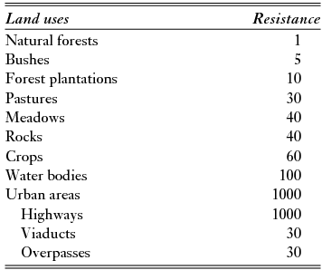
In order to propose the location of the defragmentation measures at the potentially most suitable linkages in the landscape network, we calculated the least-cost paths between each pair of nodes throughout the resistance map (Table 1), excluding the resistance values for highways. We placed the potential defragmentation locations where these least-cost paths intersect the highway network (Huck et al. Reference Huck, Jędrzejewski, Borowik, Miłosz-Cielma, Schmidt, Jędrzejewska, Nowak and Mysłajek2010; Li et al. Reference Li, Li, Li, Qiao, Yang and Zhang2010; Gurrutxaga et al. Reference Gurrutxaga, Rubio and Saura2011; Yu et al. Reference Yu, Xun, Shi, Shao and Liu2012).
In order to assess the benefits of each of the potential defragmentation locations for ecological network connectivity, we built two landscape resistance maps corresponding to the current and defragmented scenarios. Both maps included the resistance values of the highways, but they differed in whether they included or excluded the effect of the wildlife overpasses. The current resistance map did not include the lower resistance value for defragmentation locations, and therefore corresponded to the situation before the implementation of any new measure to mitigate the barrier effect of roads. The defragmented resistance map corresponded to the scenario where the permeabilization measures had been implemented. In both cases the effective distances between each pair of nodes were calculated using Pathmatrix 1.1 (Ray Reference Ray2005).
The width of the highways was reinforced for an adequate raster representation of linear elements in the resistance map in order to avoid artificial discontinuities (Rothley Reference Rothley2005). Lower resistance values were assigned to sections of highways which run through viaducts, and also to the defragmentation locations for overpasses (Table 1). Viaducts and wildlife overpass locations were assigned the same lower resistance value (Table 1) because they were considered to have similar permeability for the functional group of target species (Iuell et al. Reference Iuell, Bekker, Cuperus, Dufek, Fry, Hicks, Hlaváč, Keller, Rosell, Sangwine, Tørsløv, Wandall and le Maire2003; Mata et al. Reference Mata, Hervás, Herranz, Suárez and Malo2008; Olsson et al. Reference Olsson, Widen and Larkin2008; Kusak et al. Reference Kusak, Huber, Gomerčić, Schwaderer and Gužvica2009; Clevenger & Huijser Reference Clevenger and Huijser2011). Given the uncertainty that is usually associated with the resistance values (Rayfield et al. Reference Rayfield, Fall and Fortin2010), we performed a sensitivity analysis in order to assess the robustness of our results to the resistance value for viaducts and wildlife overpass locations. For this we used viaduct and overpass resistance values both 50% below and above the 30 value (namely, the effective distance calculations) for the cases for which the resistance value for viaducts and defragmentation locations was 15 and 45 units (the rest as in Table 1).
Mammal species vary in mobility (Bowman et al. Reference Bowman, Jaeger and Fahrig2002). Thus, we undertook the connectivity analysis in the study area taking into account a wide range of median dispersal distances (d) representing medium to large forest mammals: d = 1 km, d = 5 km, d = 10 km and d = 25 km as in Gurrutxaga et al. (Reference Gurrutxaga, Rubio and Saura2011). The median dispersal distance d in each scenario was multiplied by the median value of resistance in the resistance map, and the result determined the effective distance (accumulated cost) deff corresponding to a 0.5 direct dispersal probability between nodes (pij ) (Saura & Pascual-Hortal Reference Saura and Pascual-Hortal2007). Therefore the deff values considered in subsequent analyses and results corresponded to the effective capacity of the species to move between protected areas expressed as an accumulated movement cost (after accounting for the variable permeability and heterogeneity of the landscape matrix). A particular species with a given deff value will be able to move a larger geographical distance through permeable areas than through a matrix with abundant highways or other land cover types with high resistance values.
Ranking defragmentation locations
We quantified the connectivity of the network of protected areas (facilitated or impeded to some degree by the resistance of the landscape matrix) through the probability of connectivity (PC) index (Saura & Pascual-Hortal Reference Saura and Pascual-Hortal2007; Saura & Rubio Reference Saura and Rubio2010) expressed as:
 \begin{equation}
PC = \frac{{\sum\limits_{i = 1}^n {\sum\limits_{j = 1}^n {a_ia_jP^ * _{ij} } } }}{{A_L^2 }}\end{equation}
\begin{equation}
PC = \frac{{\sum\limits_{i = 1}^n {\sum\limits_{j = 1}^n {a_ia_jP^ * _{ij} } } }}{{A_L^2 }}\end{equation}
For each link k connecting every two protected areas i and j, we quantified the relative increase in the PC value (dPCk ) that resulted from the improvement in the strength (p*ij ) of that link after the implementation of the defragmentation measures (which, to some extent, decreased the effective distance between i and j and therefore might increase p*ij up to a point). dPCk is expressed as:
 \begin{equation}
dPC_K = 100 \times \frac{{PC_{\textit{defrag}} - PC_{\textit{current}} }}{{PC_{\textit{current}} }}\end{equation}
\begin{equation}
dPC_K = 100 \times \frac{{PC_{\textit{defrag}} - PC_{\textit{current}} }}{{PC_{\textit{current}} }}\end{equation}
We quantified the contribution to connectivity of each defragmentation measure as the sum of the dPCk values for all the links running through the location of that wildlife overpass.
RESULTS
Eleven potential defragmentation locations for wildlife overpasses were identified for construction (Fig. 1) and were ranked from highest to lowest contribution to upholding landscape connectivity for each analysed dispersal distance (Table 2). The ranking obtained was very robust to changes in the resistance value of viaducts and defragmentation locations as high as 50% from the 30 value that was selected for the case study. A change was detected in rank only for structures 7 and 8 for dispersal distances of 5, 10 and 25 km when a resistance value for viaducts and defragmentation locations of 15 units was used (Appendix 1, Tables S1 and S2, see supplementary material at Journals.cambridge.org/ENC). Two locations for wildlife overpasses were much more effective in promoting connectivity than the rest for all the dispersal distances considered (Table 2). Both were located in the central-eastern portion of the study area (Fig. 1), far from other existing crossing structures (Table 2) and between nodes with large forest areas (Fig. 1).
Table 2 Accumulated connectivity importance of each potential wildlife overpass (sum of dPCk of all links running through the overpass location) and overpass ranking (rd ) for each dispersal distance (d). The number ofo each overpass location corresponds to its position in the ranking of importance obtained for a dispersal distance of 1 km. The distance (D) from each wildlife overpass location to the nearest existing crossing structure (viaduct or tunnel) that can be used as alternative crossing is also included. For wildlife overpass locations numbers 3 and 8 there were no other crossing structures that could be used as alternative routes to reach nodes that otherwise were isolated by urban areas and highways (Fig. 1).

The defragmentation location in third position in the ranking occupied a section of the highway where there were no alternative crossing structures to access the node located to the far north-eastern area of the study (Table 2, Fig. 1). The ranking of defragmentation locations from the first to the sixth position, and those in eight and last position, was the same for all dispersal distances. The defragmentation location in eighth position was placed on a section of the highway where there was no alternative crossing structure to access a small node located between urban areas (Table 2, Fig. 1). Locations in seventh, ninth and tenth positions changed their importance ranks when the dispersal distance increased from 1 km to ≥ 5 km (Table 2). The biggest change corresponded to the defragmentation location which was in tenth position for d = 1 km, where the rank increased to seventh position for the rest of the study dispersal distances.
The importance of accumulated connectivity values obtained for each defragmentation location decreased with dispersal distance, except in the case of the overpass in third position, for which the dPC value was higher for d = 5 km than for d = 1 km (Table 2).
DISCUSSION
Over the last few decades, there has been an increasing appreciation of the importance assigned to landscape connectivity improvement to benefit biodiversity conservation within the context of global change (Opdam & Wascher Reference Opdam and Wascher2004; Heller & Zavaleta Reference Heller and Zavaleta2009), while the expansion of road networks has enhanced losses in landscape connectivity (Forman et al. Reference Forman, Sperling, Bissonette, Clevenger, Cutshall, Dale, Fahrig, France, Goldman, Heanue, Jones, Swanson, Turrentine and Winter2003; Jaeger & Fahrig Reference Jaeger and Fahrig2004; Clevenger & Wierzchowski Reference Clevenger, Wierzchowski, Crooks and Sanjayan2006; Lindenmayer & Fischer Reference Lindenmayer and Fischer2006). Our analysis revealed the contribution of each highway defragmentation location to the connectivity of the ecological network by taking into consideration four fundamental aspects: (1) the topological position of each defragmentation location in the landscape network, (2) the decrease in the effective distance among protected areas provided by each defragmentation measure, (3) the habitat area of nodes connected by the links that run through the defragmentation location, and (4) the dispersal distance of the focal species. The decrease in effective distance was relatively higher for those defragmentation locations situated in areas where other alternative adequate wildlife crossing structures were distant or non-existant. Thus, the defragmentation locations ranking sixth and ninth for d = 1 km (Table 2) made a relatively modest contribution, even though they potentially supported relevant links between large nodes (Fig. 1). In both cases, the existence at a short distance of a viaduct provided alternative links at a similar functional distance. The defragmentation locations in the first two positions (Table 1) were located in sections where there were no other adequate wildlife crossing structures nearby, as in earlier field studies at a local level (Gurrutxaga et al. Reference Gurrutxaga, Lozano and del Barrio2010 b). The species dispersal distance also affected the ranking obtained; for example, the defragmentation location in tenth position for d = 1 km increased its rank to the seventh for d ≥ 5 km, due to the higher ability of species to cross the broad agrarian area where it was located. In relation to the dispersal distances analysed, in general the species with lower dispersal abilities benefited the most from the implementation of defragmentation measures (Table 2) because they were more greatly affected than more mobile species by the connectivity bottlenecks caused by highways (van der Grift & Pouwels Reference van der Grift, Pouwels, Davenport and Davenport2006; Saura & Rubio Reference Saura and Rubio2010; Gurrutxaga et al. Reference Gurrutxaga, Rubio and Saura2011). However, the overpass location which was in third position obtained a higher accumulated connectivity importance for d = 5 km than for d = 1 km (Table 2). The links that ran through it gained a higher relative importance for d = 5 km due to their greater capacity to connect the node located at the north-eastern end of the study area with other forest protected areas.
Previous studies at broad spatial scales focused on the identification of spatial interactions between ecological networks and human transport networks to detect road sectors in which adequate defragmentation and barrier effect mitigation measures should be implemented (Carr et al. Reference Carr, Zwick, Hoctor, Harrell, Goethals, Benedict, Evink, Garrett, Zeigler and Berry1998; Clevenger & Wierzchowski Reference Clevenger, Wierzchowski, Crooks and Sanjayan2006; Huck et al. Reference Huck, Jędrzejewski, Borowik, Miłosz-Cielma, Schmidt, Jędrzejewska, Nowak and Mysłajek2010; Li et al. Reference Li, Li, Li, Qiao, Yang and Zhang2010; Gurrutxaga et al. Reference Gurrutxaga, Rubio and Saura2011; Yu et al. Reference Yu, Xun, Shi, Shao and Liu2012). Most of these used least-cost path analysis as a support tool for the placement of priority defragmentation locations (Clevenger & Wierzchowski Reference Clevenger, Wierzchowski, Crooks and Sanjayan2006; Huck et al. Reference Huck, Jędrzejewski, Borowik, Miłosz-Cielma, Schmidt, Jędrzejewska, Nowak and Mysłajek2010; Li et al. Reference Li, Li, Li, Qiao, Yang and Zhang2010; Gurrutxaga et al. Reference Gurrutxaga, Rubio and Saura2011; Yu et al. Reference Yu, Xun, Shi, Shao and Liu2012), but did not take into account the variation in the effective distance between links before and after the implementation of defragmentation measures, and thus could not assess the different contribution of each of them to upholding habitat connectivity and availability (reachability) in the landscape, as related to species movement. We think that our approach, which prioritizes those specific defragmentation locations that most contribute to upholding habitat connectivity and availability in an ecological network, represents a significant contribution to decision making in barrier effect mitigation measures in road defragmentation programmes. The methodological approach presented here allows a fine-scale assessment of specific locations for potential defragmentation measures along the roads, rather than a generic and spatially coarse analysis where the barrier effect of an entire road (or road sector) is evaluated. This involves the study of more realistic scenarios of the impacts of roads and their permeability, rather than assuming that species movement is homogeneously impeded by a road or fully allowed when it is absent.
This methodological approach could be easily adapted and replicated in other studies and applications for defragmentation of transport infrastructures to wildlife, including not only strictly forest species, but also those other species that are associated with non-forested habitats and are affected by the barrier effect of roads. Further research and improvements in the approach could also comprise the integration of empirical data to provide better-supported estimates of the model parameters (node identification and habitat quality, dispersal distances and resistance map) or to validate the model results, either for individual species or for functional groups of species with similar ecological profiles. These empirical data could include species distribution, habitat use or home range data, telemetry (Zeller et al. Reference Zeller, McGarigal and Whiteley2012), records of wildlife-vehicle collisions (Glista et al. Reference Glista, DeVault and Woody2009) or genetic data to infer gene flow in the landscape (Ruiz-Gonzalez et al. Reference Ruiz-González, Gurrutxaga, Madeira, Lozano, Fernández and Gómez-Moliner2010; Shirk et al. Reference Shirk, Wallin, Cushman, Rice and Warheit2010). Moreover, monitoring of species movement before and after road defragmentation measures implementation could be used in diachronic studies determining the actual benefits of these measures for different species. Future research could also focus more specifically on studying the role of the road permeabilization efforts with regard to the adaptation of the biota to climate change, an aspect which has received relatively little attention (Clevenger Reference Clevenger2012). The methodological approach presented here might be similarly used in multiple planning or modelling applications at different spatial and temporal scales, evaluating the effects in landscape connectivity of different restoration, land use or climate change scenarios, beyond the transport infrastructures defragmentation measures here considered.
ACKNOWLEDGEMENTS
This work was supported by the Spanish Ministry of Science and Innovation through CONECTERR (CSO2011-23653), DECOFOR (AGL2009-07140/FOR) and GEFOUR (AGL2012-31099) projects, and the Department of Education, Universities and Research of the Basque Government through SBPD (IT575-13) project.


