

The Mississippian (Tournaisian) Ballagan Formation of northern Britain hosts a diverse assemblage of vertebrate fossils, including the earliest known tetrapods with terrestrial capability (Clack Reference Clack2002; Clack & Finney Reference Clack and Finney2005; Smithson et al. Reference Smith2012; Clack et al. Reference Clack, Bennett, Carpenter, Davies, Fraser, Kearsey, Marshall, Millward, Otoo, Reeves, Ross, Ruta, Smithson, Smithson and Walsh2016; Smithson & Clack Reference Smithson and Clack2018). This is one of only two successions in the world where such fossils have been found within the period of about 15 million years at the beginning of the Carboniferous and has become known as Romer's Gap. The other is the Horton Bluff Formation in Nova Scotia, Canada (Anderson et al. Reference Anderson, Smithson, Mansky, Meyer and Clack2015), which at this time was relatively close along the southern margin of Laurussia. The emergence of tetrapods on land and their subsequent diversification follows the mass extinction events in late Devonian times (Kaiser et al. Reference Kaiser, Aretz, Becker, Becker, Königshof and Brett2015). Understanding how, why and under what conditions this step change in the evolution of life on Earth occurred was part of the remit of the TW:eed Project led by Jenny Clack from 2012 until 2016. So, what were the landscape, palaeoenvironments and habitats like at this time?
Francis et al. (Reference Francis, Forsyth, Read and Armstrong1970) and later studies have all inferred a coastal floodplain setting, although earlier Belt et al. (Reference Belt, Freshney and Read1967) had proposed a marginal marine to restricted marine environment for dolostone deposition in the Ballagan Formation of the Midland Valley of Scotland. The Anderton (Reference Anderton1985) conceptual facies model for the important fish-bearing succession at Foulden in the Tweed Basin was based on detailed sedimentary logging. This type of model has been developed further by Bennett et al. (Reference Bennett, Kearsey, Davies, Millward, Clack, Smithson and Marshall2016, Reference Bennett, Howard, Davies, Kearsey, Millward, Brand, Browne, Reeves and Marshall2017), Kearsey et al. (Reference Kearsey, Bennett, Millward, Davies, Gowing, Kemp, Leng, Marshall and Browne2016) and Millward et al. (Reference Millward, Davies, Williamson, Curtis, Kearsey, Bennett, Marshall and Browne2018) from detailed investigations of sandy siltstones, ichnofacies, palaeosols and evaporite rocks displayed in the successions through the formation exposed at Burnmouth and in the cores from the Norham West Mains Farm Borehole near Berwick upon Tweed (Fig. 1). All of these models show the rapidly changing character of the sedimentary environments in the rock record, suggesting the juxtaposition of a mosaic of distinctive habitats within a strongly seasonal, tropical coastal wetland. These studies are applicable particularly to the Tweed Basin (Fig. 1), but how do they extend across the broader region of northern Britain? This is important because the palaeogeography of the region and its control on the distribution of palaeoenvironments and habitats may have played a role in shaping vertebrate evolution.

Figure 1 Outcrop and subsurface map of Tournaisian rocks in the Midland Valley of Scotland, Tweed and Northumberland Solway basins. These strata include the Ballagan Formation and part of the Lyne Formation in the last basin. Major boreholes and thickness of the formation are shown. Outcrop data from the British Geological Survey DiGMapGB© NERC 2015; subcrop extent in the Northumberland–Solway basin from Chadwick et al. (Reference Chadwick, Holliday, Holloway and Hulbert1995).
The Tournaisian palaeogeography of the Midland Valley, and the Tweed and Northumberland–Solway basins presented here has its origins in the seminal atlases of the UK by Wills (Reference Wills1951) and Cope et al. (Reference Cope, Guion, Sevastopulo, Swan, Cope, Ingham and Rawson1992). The TW:eed Project studies have provided greater clarity of detail and connections across the region between the sedimentary environments, habitats and the tetrapods that lived in them (Clack et al. Reference Clack, Bennett, Carpenter, Davies, Fraser, Kearsey, Marshall, Millward, Otoo, Reeves, Ross, Ruta, Smithson, Smithson and Walsh2016). The new map combines data from field sections and borehole records through the Ballagan Formation in the Midland Valley and Tweed Basin and includes reflections on published interpretations of the Northumberland–Solway Basin. These investigations provide new insights into this rare example in the geological record of an equatorial seasonal coastal wetland.
1. Regional setting and stratigraphy
During the early Mississippian, interconnected strike-slip fault-controlled sedimentary basins opened across northern Britain as a result of the break-up of the equatorial, southern part of the Laurussian continental margin (Coward Reference Coward1993; Domeier & Torsvik Reference Domeier and Torsvik2014). The northern basins include those in the Midland Valley, Tweed and Northumberland–Solway regions. Volcanism accompanied opening of the Tweed and Northumberland–Solway basins (Leeder Reference Leeder1974a; Chadwick et al. Reference Chadwick, Holliday, Holloway and Hulbert1995). The early sedimentary fill to the basins comprises the Ballagan Formation, which was preceded by the upper Devonian Kinnesswood Formation and succeeded in various parts of the region by the Clyde Sandstone, Garleton Hills Volcanic, Lyne and Fell Sandstone formations (Figs 1, 2).

Figure 2 Stratigraphy chart for the region (after Waters et al. Reference Waters, Somerville, Jones, Cleal, Collinson, Waters, Besly, Dean, Stephenson, Davies, Freshney, Jackson, Mitchell, Powell, Barclay, Browne, Leveridge, Long and McLean2011). Ballagan Formation (Browne Reference Browne1980) subsumes the Tyninghame Formation (Chisholm et al. Reference Chisholm, McAdam and Brand1989), Cementstone Group (Miller Reference Miller1887; Greig Reference Greig1988) and part of the Lower Border Group (Lumsden et al. Reference Lumsden, Tulloch, Howells and Davies1967; Day Reference Day1970; Leeder Reference Leeder1974b). The Kinnesswood, Ballagan and Clyde Sandstone formations comprise the Inverclyde Group (Browne et al. Reference Browne, Dean, Hall, McAdam, Monro and Chisholm1999). The miospore biozones of the Ballagan Formation are from Stephenson et al. (Reference Stephenson, Williams, Monaghan, Arkley and Smith2002, Reference Stephenson, Williams, Leng and Monaghan2004a, Reference Stephenson, Williams, Monaghan, Arkley, Smith, Dean, Browne and Lengb), Williams et al. (Reference Williams, Stephenson, Wilkinson, Leng and Miller2005) and Smithson et al. (Reference Smithson, Wood, Marshall and Clack2012). Abbreviations: KCBV=Kelso, Cottonshope and Birrenswark volcanic formations; W=Whita Sandstone Member.
The Ballagan Formation is preserved at outcrop and in the subsurface across the Midland Valley and Tweed Basin, and this passes southward and stratigraphically upward into the Lyne Formation in the Northumberland–Solway Basin (Fig. 2). The Ballagan Formation consists of grey siltstone and thin beds of argillaceous ferroan dolostone (historically referred to as ‘cementstone'), with varying proportions of sandstone, flood-deposited sandy siltstone, palaeosols and evaporite rock (Anderton Reference Anderton1985; Scott Reference Scott1986; Andrews et al. Reference Andrews, Turner, Nabi and Spiro1991; Andrews & Nabi Reference Andrews and Nabi1994, 1998; Bennett et al. Reference Bennett, Kearsey, Davies, Millward, Clack, Smithson and Marshall2016; Kearsey et al. Reference Kearsey, Bennett, Millward, Davies, Gowing, Kemp, Leng, Marshall and Browne2016; Millward et al. Reference Millward, Davies, Williamson, Curtis, Kearsey, Bennett, Marshall and Browne2018). The formation is best exposed in the 520m thick, vertically dipping, coastal section at Burnmouth (Fig. 1). Though a late Tournaisian, CM Miospore Biozone age (e.g., Neves et al. Reference Neves, Gueinn, Clayton, Ioannides, Neville and Kruszewska1973; Neves & Ioannides Reference Neves and Ioannides1974; Stephenson et al. Reference Stephenson, Williams, Monaghan, Arkley and Smith2002) has been determined for the formation in central Scotland, Smithson et al. (Reference Smithson, Wood, Marshall and Clack2012) recorded earliest Tournaisian, VI Biozone miospores from the base of the formation at Burnmouth. Most recently, Marshall et al. (Reference Marshall, Reeves, Bennett, Davies, Kearsey, Millward, Smithson and Browne2019) provide evidence that in the Tweed Basin the formation spans the Tournaisian. In East Lothian, the upper part of the formation has yielded early Visean Pu Biozone miospores (Neves et al. Reference Neves, Gueinn, Clayton, Ioannides, Neville and Kruszewska1973; Neves & Ioannides Reference Neves and Ioannides1974); these upper beds are therefore laterally equivalent to the Clyde Sandstone Formation of the west of the Midland Valley which is inferred to be lower Visean (Waters et al. Reference Waters, Somerville, Jones, Cleal, Collinson, Waters, Besly, Dean, Stephenson, Davies, Freshney, Jackson, Mitchell, Powell, Barclay, Browne, Leveridge, Long and McLean2011).
The thickness of the Ballagan Formation ranges from a few tens of metres on the Isle of Bute, to 80m in north Arran (Young & Caldwell Reference Young and Caldwell2012), 150m in the west of the Midland Valley and in Fife, up to 355m in Ayrshire (Stephenson et al. Reference Stephenson, Williams, Monaghan, Arkley and Smith2002), and possibly up to 900m west of Edinburgh (Fig. 1; Mitchell & Mykura Reference Mitchell and Mykura1962). At least 418m are present in East Lothian, but only 200m at Birnieknowes at the NE margin of the Southern Upland massif. Approximately 520m occur in the Tweed Basin whereas in the Northumberland–Solway Basin Tournaisian and Chadian strata may be up to 3400m thick in the centre of this asymmetric graben (Chadwick et al. Reference Chadwick, Holliday, Holloway and Hulbert1995). The formation is absent from the central part of the Midland Valley, having been eroded during mid-Visean (Arundian) uplift prior to the Clyde Plateau volcanism (Millward & Stephenson Reference Millward and Stephenson2011).
In stark contrast to the Ballagan Formation, the Kinnesswood and Clyde Sandstone formations comprise braided fluvial sandstone in upward-fining cycles, interbedded with overbank red and purple mudstone, multiple intervals with carbonate nodules and thin beds of concretionary limestone (‘cornstones'; Eyles et al. Reference Eyles, Simpson and MacGregor1949; Read & Johnson Reference Read and Johnson1967; Francis et al. Reference Francis, Forsyth, Read and Armstrong1970; Leeder Reference Leeder1976; Leeder & Bridges Reference Leeder and Bridges1978; Young & Caldwell Reference Young and Caldwell2011, Reference Young and Caldwell2012). The ‘cornstones' are palaeosols with pedogenic carbonate nodules (Burgess Reference Burgess1961; Leeder Reference Leeder1976; Andrews et al. Reference Andrews, Turner, Nabi and Spiro1991; Wright et al. Reference Wright, Turner, Andrews and Spiro1993).
In the Northumberland–Solway Basin the Lyne Formation (formerly Lower Border Group of, e.g., Lumsden et al. Reference Lumsden, Tulloch, Howells and Davies1967; Leeder Reference Leeder1975a, Reference Leederb) is Tournaisian and early Visean in age, and contains significant marine clastic and carbonate sedimentary rocks and fossils (Leeder Reference Leeder1974b; Brand Reference Brand2018). The Lyne and Ballagan formations are overlain unconformably by the Fell Sandstone Formation in the Tweed Basin and eastern part of the Northumberland–Solway Basin. The Fell Sandstone is composed of a stacked succession of mainly coarse-grained sandstone deposited from the first major Carboniferous fluvio-deltaic system to cross the region (Kearsey et al. Reference Kearsey, Millward, Ellen, Whitbread, Monaghan, Monaghan, Underhill, Hewett and Marshall2018).
2. Methods
The palaeogeography is reconstructed using data from field exposures across the Midland Valley and Tweed basins, and from about 40 borehole logs from the British Geological Survey (BGS) archive that proved significant occurrences of Tournaisian strata. A sub-set of 12 boreholes, commissioned by BGS as part of the stratigraphical investigation of Upper Devonian and Mississippian rocks of the region from 1967 to 1981, provides descriptions and consistent information on the spatial and temporal occurrence, context and general form of the different lithofacies. Cores have been retained for only one of these, the Glenrothes Borehole, and visual inspection of these provided additional information.
It is to be expected that the archived logs vary in amount and quality of information they contain because they were made over more than 100 years. The BGS sub-set provides the greatest volume of data, though even here variations in data quantity and quality arise because they were logged by different geologists. Information is particularly sparse on palaeosols and sandy siltstones. Palaeosols are under-described in UK geology generally, though rooted ‘seat-earths' have long been recognised by Geological Survey staff because of extensive work in the coalfields. Sandy siltstone is a facies only recently identified from the Ballagan Formation and so is not recorded (Bennett et al. Reference Bennett, Kearsey, Davies, Millward, Clack, Smithson and Marshall2016). Therefore, interpretation of the facies from these boreholes (Table 1) is informed and benchmarked against the facies analysis of the Norham West Mains Farm Borehole undertaken by Bennett et al. (Reference Bennett, Kearsey, Davies, Millward, Clack, Smithson and Marshall2016; Table 1). This borehole is located in the Tweed Basin, about 10km SW of Berwick upon Tweed, and fully cored 491m of the Ballagan Formation (Fig. 1; Millward et al. Reference Millward, Kearsey and Browne2013).
Table 1 Facies, facies associations and environments in the Ballagan Formation of the Midland Valley of Scotland and Tweed Basin. The marginal marine facies of the Lyne Formation Northumberland–Solway Basin are omitted. Facies descriptions are from the archived borehole logs in the BGS collections and from key exposures. Facies association after Bennett et al. (Reference Bennett, Kearsey, Davies, Millward, Clack, Smithson and Marshall2016).

The BGS collections contain macrofossils from the Ballagan and Lyne formations from 235 localities, including many of the boreholes, collected over a period of more than 100 years. The fossils have been re-examined for this study to ensure taxonomic consistency (Brand Reference Brand2018). The biogeographical distribution of marine taxa and ‘Estheria' are included herein as they provide additional insight alongside the sedimentary data. Raymond (Reference Raymond1946, p. 219) noted that ‘Estheria' is an invalid name for a conchostracan genus as the name was pre-occupied, and he erected a number of genera in which to allocate the known species. Unfortunately, he did not allocate all the Scottish described species to his genera, and preservation of the material from the Ballagan Formation often precludes even a generic allocation.
3. Sedimentary facies
Facies identified in selected exposures and the archived borehole logs are described in Table 1, and examples illustrated in Figure 3. Summary statistics for selected features in the borehole logs are given in Table 2. The stratigraphical variation of facies across the Midland Valley is shown in Figures 4 and 5.
Table 2 Summary statistics for Ballagan Formation in selected BGS boreholes. Abbreviations: BGN=Ballagan Formation; CYD=Clyde Sandstone Formation; FESD=Fell Sandstone Formation; GHV = Garleton Hills Volcanic Formation; GUL=Gullane Formation; KNW = Kinnesswood Formation; LLGS=Lower Limestone Formation.

1 Log descriptions of mudstone and siltstone units in the Ascog Borehole contain insufficient detail for analysis.

Figure 3 Sedimentary logs of sections drawn up from the archived BGS borehole logs to illustrate features of the facies associations. Glenrothes Borehole: flood-plain lake facies, saline and hypersaline lake facies association intercalated with overbank facies association; original written log by D. N. Halley, A. A. McMillan and M. A. E. Browne. East Linton Borehole: overbank facies association, with subordinate saline and hypersaline lake facies association; original written log by A. D. McAdam. Birnieknowes Borehole: fluvial facies associations, with overbank facies association and floodplain lakes; author of original written log not recorded.

Figure 4 Summary lithological logs and environmental interpretations for selected boreholes in the west and north of the Midland Valley of Scotland. Borehole locations are shown in Figure 1. The black curves within the stratigraphical columns represent the proportional thickness of grey, laminated siltstone/mudstone per 10m interval through the succession. The key to the lithology colours is given in Figure 5.
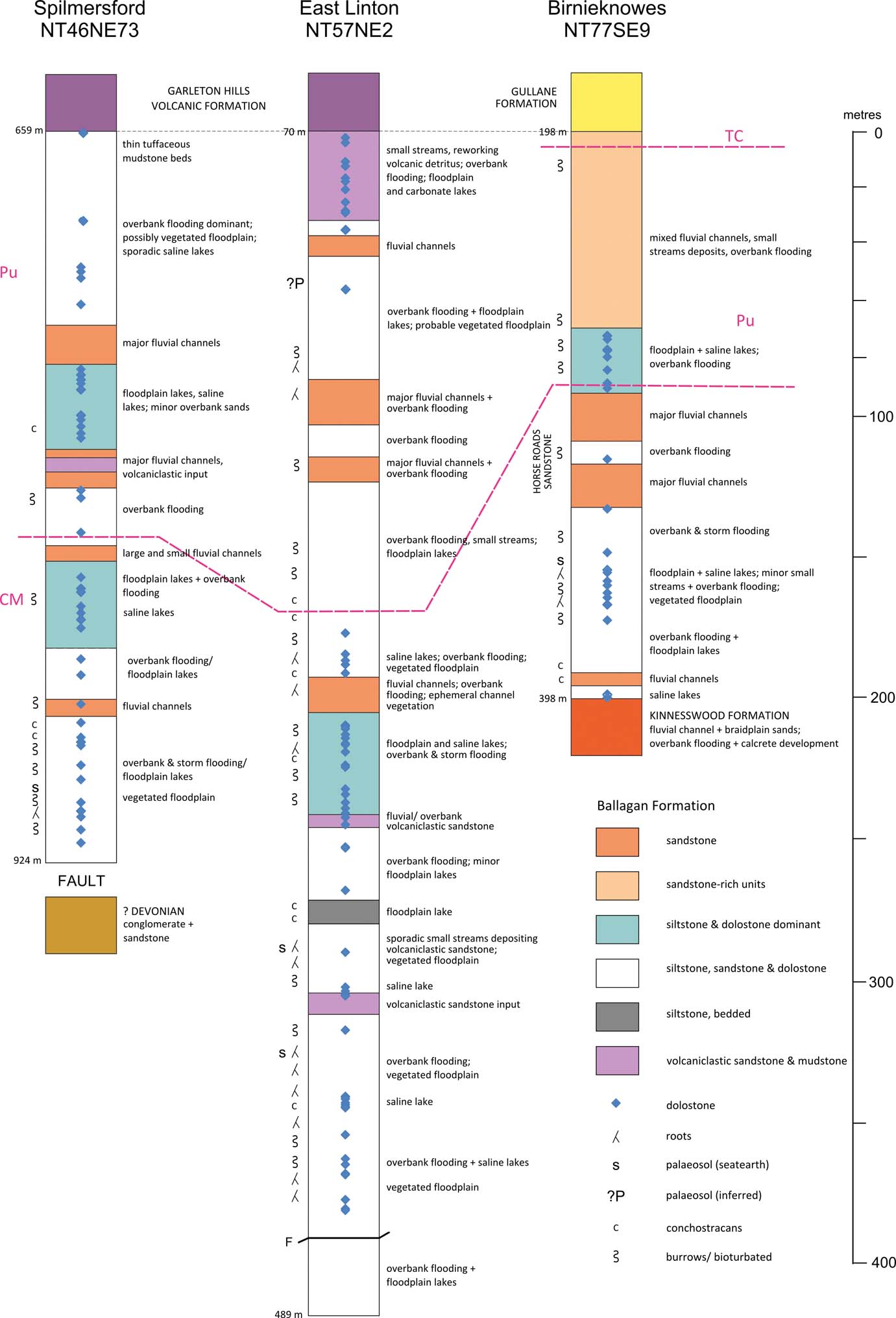
Figure 5 Summary lithological logs and environmental interpretations for selected boreholes in the east of the Midland Valley of Scotland. Borehole locations are shown in Figure 1. The miospore biozones CM, Pu and TC are from Davies et al. (Reference Davies, McAdam and Cameron1986).
The succession in the west and north of the Midland Valley mostly comprises small-scale intercalations of packages of dolostone and grey siltstone, along with heterogeneous siltstone and fine-grained sandstone, and locally, evaporite rock; these abruptly interdigitated facies constitute the saline and hypersaline lake and overbank facies associations (Figs 3, 4). Laterally continuous distinctive units that might be suitable for correlation across the region are not present, though the uppermost part of the formation is sand-rich in parts. At the base of the formation in Fife and Tayside, a unit of distinctive dolostone beds, 32m thick, comprises the Mains of Errol Member (Browne Reference Browne1980). By contrast, in the east, the succession is more heterogeneous with thick distinctive packages of, for example, fluvial sandstone and floodplain-lake siltstones within a mixed assemblage of fluvial and overbank facies associations (Figs 3, 5). The position of the base of the Pu Miospore Biozone suggests that some of the packages in East Lothian may be correlated, at least over a distance of about 15km.
3.1. Siltstone, dolostone and evaporite facies
Thin beds of micritic ferroan dolostone interbedded with planar laminated, grey siltstone are the defining characteristic of the Ballagan Formation. Siltstone occurs in both the saline and hypersaline lake facies association, and the overbank facies association (Fig. 3). Laminated grey siltstone comprises a high proportion of the fines component in some of the boreholes, for example 99% in Blairmulloch and 89% in Loch Humphrey (Table 2), but is generally lower in the East Lothian boreholes. Thick packages of laminated grey siltstone in the boreholes with high proportions of fine sediment are likely to represent floodplain-lake deposits, though these may include misidentified thin beds of sandy siltstone. Laminated grey siltstone associated with the upper part of massive and cross-bedded sandstone may fill fluvial channels. The overbank facies association includes grey, yellow, red and purple siltstone, only some of which is described as having traces of bedding; these may be palaeosols, but the descriptions are insufficient for a diagnosis.
After removing the sandstone component from each borehole, dolostones comprise 3–21% of the thickness of the remainder of the succession. The number of dolostone beds varies from nine in the Ascog Borehole to 277 in Norham, with the average thickness ranging from 9cm in Ascog to 34cm in East Linton (Table 2). Thus, in the boreholes of the western and northern part of the region, dolostone beds occur on average every 0.9m (Glenrothes) to 1.7m (Knocknairshill, Blairmulloch; Fig. 3). By contrast, dolostone beds are, on average, less common in the East Lothian boreholes, but there the concentration of dolostone beds within packages of laminated grey siltstone up to 35m thick is strongly evident, with significant packages of overbank siltstone and fine-grained sandstone devoid of dolostone beds (Fig. 5).
Apart from the thickness, few descriptive details of the dolostone beds are typically given, though some are described as ironstone (Davies et al. Reference Davies, McAdam and Cameron1986; Greig Reference Greig1988). Belt et al. (Reference Belt, Freshney and Read1967), Francis et al. (Reference Francis, Forsyth, Read and Armstrong1970) and Scott (Reference Scott1986) identified dolostone nodules, laminated beds (Fig. 8d), evaporite-bearing beds and massive beds; the last of these become more argillaceous at the base and top. Identification of these differing facies is aided by slicing the cores, but information from the borehole logs is insufficient to make the distinctions in all but the evaporite-bearing dolostones.
Small-scale evaporite deposits are a characteristic of the Ballagan and other Tournaisian formations in the British Isles (Millward et al. Reference Millward, Davies, Williamson, Curtis, Kearsey, Bennett, Marshall and Browne2018). They are distributed spatially and temporally throughout the succession in the Midland Valley and Tweed Basin, though they are absent from the Lothians and from the area bordering the Highlands (Figs 4, 5). Nodules of gypsum occur in siltstone and dolostone; calcite and dolomite pseudomorphs occur in the latter at Burnmouth and in some of the boreholes (Scott Reference Scott1986; Millward et al. Reference Millward, Davies, Williamson, Curtis, Kearsey, Bennett, Marshall and Browne2018). Siltstone pseudomorphs after hopper crystals of halite are recorded locally in boreholes (Fig. 4) and in exposures, for example in the Langholm area, Chattlehope Burn, Northumberland and Willie's Hole, Scottish Borders (Leeder Reference Leeder1974b; Cater et al. Reference Cater, Briggs and Clarkson1989).
3.2. Mains of Errol Member
The Mains of Errol Member (Fig. 4; Browne Reference Browne1980) comprises beds of hard dolomicrite, with a characteristic reddened, cracked and ‘pseudobrecciated' profile (Fig. 6). The top of each profile is a sharp planar contact. Roots and burrows are absent; ostracods and fish fragments are rare and other fossils absent. Dolostone beds, 0.22–1.70m thick, are either stacked on top of each other, or they are intercalated with units of laminated siltstone or sandy siltstone. The dolostone is composed of planar-textured subhedral dolomite with crystal size up to 10μm. A pseudobrecciated texture shows ‘clasts' of finer grained dolomite set in coarser grained dolomite. Quartz grains scattered throughout the rock are etched, suggesting corrosion in alkaline fluids. A few rhombohedra composed of dolomite aggregates are probably pseudomorphs after gypsum. Scattered clasts up to 500μm composed of chlorite and feldspar may be volcanic in origin.

Figure 6 Sedimentary logs through selected dolostone units in the Mains of Errol Member in the Glenrothes cores.
From just above each dolostone unit base, isolated, narrow sinuous cracks widen upwards as they unite with adjacent ones (Fig. 6). At their upper termination against subhorizontal planar dislocations these cracks are polygonal and up to 20mm across on the bedding surface. The cracks are filled with iron (Fe)-rich claystone. Above the cracked zone, 20–40cm of dolostone are intensely brecciated, with poorly sorted, angular clasts of dolostone from 1 to 20mm across, set in a Fe-rich claystone. In this zone and the top part of the underlying cracked zone, low-angle, concave-upwards dislocations resemble pedogenic slickensides. In the most fully preserved profiles the uppermost 5–10cm are composed mainly of red-brown, Fe-rich claystone, with sporadic dolostone clasts, 1–5mm across. Similar beds have been reported from a borehole in the Stirling area (Francis et al. Reference Francis, Forsyth, Read and Armstrong1970, plate 4, fig. 7).
3.3. Sandstone
Sandstone facies occur within the fluvial and overbank facies associations (Bennett et al. Reference Bennett, Kearsey, Davies, Millward, Clack, Smithson and Marshall2016). All sandstone contains abundant partings of mica and carbonaceous detritus. The proportion of sandstone in the succession varies across the region (2–46%; Table 2), with the higher amounts in East Lothian and the Tweed Basin (24% in East Linton Borehole, 32% in Spilmersford and 46% in Birnieknowes) (Fig. 7). By contrast, in boreholes in the north of the Midland Valley, sandstone is most commonly seen at the base and top to the formation, though in the Ascog Borehole it occurs throughout (Fig. 4). Units up to 3m thick occur in all the boreholes, with the median occurrence less than 50cm thick (Fig. 7). Typically, these thin units of sandstone are described as fine-grained and ripple-laminated or cross-laminated. Many are interbedded with siltstone and are interpreted as deposited by overbank flooding and crevasse splays. A few units in this interval are recorded as having a sharp, erosive base and massive or cross-bedded and may represent channel sandstone bodies.

Figure 7 Histograms for key Midland Valley boreholes showing the frequency of sandstone bodies of a given thickness interval. The percentages shown for the thicker units are of the total sandstone thickness in the borehole succession.
By contrast, the Blairmulloch and East Lothian boreholes also contain sandstone units more than 3m thick (Fig. 7). Though the number of such units is small, they make up a high proportion of the total thickness of the sandstone component in the succession; for example, three units in Spilmersford constitute 31% of the sandstone thickness and in Birnieknowes 63% (Table 2). These sandstone bodies are described as sharp-based, medium and coarse grained, massive or cross-bedded (Fig. 3) and may include mudstone rip-up clasts and conglomerate layers in the lower part. A thin upper part typically is finer grained and planar laminated to ripple laminated. Thicknesses vary from just a few metres up to 15m in the Spilmersford, East Linton and Birnieknowes boreholes. The 11.4m thick sandstone unit illustrated in Figure 3 is typical of many, comprising stacked subunits separated by a thin bed of siltstone, suggesting that the thicker sandstone bodies represent multiple-storey channel fills. Lenticular beds of conglomerate at the base of sandstone units at Burnmouth host disarticulated vertebrate bones.
The geometry of one of these sandstone units is seen in the river cliff of the Whiteadder River at Edington Mill [NT 894 548] (Fig. 8a, c). The lower part of the channel cuts sharply down about 4m into the underlying siltstone-dolostone succession. Rotated blocks of siltstone-dolostone suggest that the channel margin collapsed during formation (Fig. 8c). The channel fill shows lenticular units of cross-bedded sandstone with lateral accretion at the channel base. Clasts of dolostone in the thalweg can be traced to a bed cut by the channel. Beds in the upper part of the channel thicken to the right in Figure 8a. Another unit, more than 20m thick, near the top of the formation, and exposed along the SE bank of the River Tweed at Norham is strongly trough cross-bedded with sediment transport consistently towards the SW.

Figure 8 Images illustrating features of the Ballagan Formation. (a) Fluvial channel cut into interbedded siltstone, fine-grained sandstone and dolostone alongside the Whiteadder Water at Edington Mill [NT 894 548]. Detail in white rectangle in (c). Fisherman, bottom centre, for scale. (b) Desiccation cracks, Dunbar shore. (c) Detail of channel side, showing multiple dislocations probably caused by collapse of the channel bank. (d) Laminated dolostone, Glenrothes borehole, depth 305.65m; core 95mm wide. (e) Sandy siltstone in Mains of Errol Member – dolomitised siltstone containing small dark fragments of siltstone; Glenrothes borehole, depth 358.21m; core 78mm diameter. (f) Scan of thin section of oncolite-bearing limestone. Located at top of the formation, just beneath the Fell Sandstone, Coomsdon Burn [NY 710 038].
At the coastal locality of Burnmouth in the Tweed Basin, a number of sandstone fluvial bodies are exposed in the almost vertical strata of the wave-cut platform and cliff. Depicted on a geological excursion map, Scrutton & Turner (Reference Scrutton, Turner and Scrutton1995) numbered the large sandstone bodies 1 (youngest) to 14 (oldest). Analysis of these bodies indicates that a number are multistorey and multilateral, and can be traced across the wave-cut platform for up to a kilometre. Lateral accretion deposits (2–3m thick) are recognised in several bodies. Whereas individual channels may only reach 3m in thickness, one or two of the multistorey systems comprise a total in excess of 30m. In general, the erosive bases to the channels cut into the underlying floodplain sedimentary rocks, but some systems cut into the dolostones, representing lake deposits.
Poorly bedded volcaniclastic rocks within the Ballagan Formation are described here for the first time from the Spilmersford and East Linton boreholes (Fig. 5). They occur both within, and at the top of, the formation, interbedded with sandstone and siltstone. A unit in the lower part of the East Linton Borehole is 7.9m thick with beds ranging from 24cm to 1.5m thick. They are composed of multicoloured fragments of volcanic rock of medium sand through gravel grade, with some dolostone, siltstone and sporadic chert clasts. These rock types have not been reported from elsewhere in the formation.
3.4. Emergent surfaces and palaeosols
Desiccation cracks and brecciated, upper parts of beds, both at outcrop and in boreholes, represent short-lived episodes of emergence and drying out of the sediment. At least five horizons are seen, for example, in the upper part of the shallowly dipping succession in the well exposed coastal section at Belhaven Bay, west of Dunbar (Fig. 8), but there is great variation in abundance across the Midland Valley (Fig. 9; Table 2). Glenrothes and East Dron borehole logs contain 138 and 110 horizons respectively, similar to 131 in the Norham core of the Tweed Basin (Figs 3, 9). By contrast, the very low numbers of desiccated surfaces in the other boreholes may inversely relate to the high proportion of laminated grey mudstone present, representing extended periods of sedimentation in perennial bodies of standing water. Alternatively, the low numbers may reflect under-recording of detail.

Figure 9 Occurrence of sedimentary features and fossils recorded in selected boreholes across the east of the Midland Valley.
The preservation of plant roots and palaeosols indicates established episodes of emergence and vegetation cover. Carpenter et al. (Reference Carpenter, Falcon-Lang, Benton and Henderson2015) interpreted the mottled red mudstone beds containing carbonate nodules and vertic cracks within the thin succession on the Isle of Bute as well drained, seasonally dry palaeosols. Near Foulden, Retallack & Dilcher (Reference Retallack and Dilcher1988) inferred that gleyed inceptisols were populated by small shrubby ferns such as Lyrasperma scotica and vertisols by tall forest trees such as the reconstructed Stamnostoma huttonense. Kearsey et al. (Reference Kearsey, Bennett, Millward, Davies, Gowing, Kemp, Leng, Marshall and Browne2016) described 216 palaeosols from the Norham core and 64 from the exposed section at Burnmouth in the Tweed Basin. Nineteen vertisols occur in the Norham core and 15 at Burnmouth, representing extended periods of stabilised floodplain. Some 60% of the vertisols have a gleyed top, indicating that the soils were finally flooded by surface waters (Kearsey et al. Reference Kearsey, Bennett, Millward, Davies, Gowing, Kemp, Leng, Marshall and Browne2016).
Few palaeosols are described in the archived borehole logs (Table 2). In the Glasgow and Ayrshire logs there are sporadic mentions of ‘seatearths' and ‘seat clay', typically associated with carbonised root traces; the absence of coals capping these suggest that they probably equate to the gleyed inceptisols of Kearsey et al. (Reference Kearsey, Bennett, Millward, Davies, Gowing, Kemp, Leng, Marshall and Browne2016). Roots in the top of sandstone beds are likely to be the entisols described by Kearsey et al. (Reference Kearsey, Bennett, Millward, Davies, Gowing, Kemp, Leng, Marshall and Browne2016). However, the depth and form of rooting is not given. Massive, red-, brown- and yellow-mottled siltstone, particularly in the East Lothian boreholes and sporadically elsewhere, might suggest that vertisols are also present there, but indicative evidence of vertic cracks and pedogenic slickensides is missing. However, in many of the logs from the west and north of the Midland Valley, the high proportion of laminated grey siltstone present would seem to preclude the presence of well-developed palaeosols from those parts of the succession. This is also the case with the Glenrothes core, visual inspection of which showed the presence of very few palaeosols of any type.
3.5. Sandy siltstone
Matrix-supported sandy siltstone with millimetre-sized rock clasts and bioclasts was first described from the Ballagan Formation from the Norham core and at Burnmouth by Bennett et al. (Reference Bennett, Kearsey, Davies, Millward, Clack, Smithson and Marshall2016). The 146 and 71 beds respectively from the two sections are mostly less than 1m thick; sandy siltstone makes up about 6% of the succession and typically overlies palaeosols or desiccated horizons. The deposits have lateral extents of up to several tens of metres at Burnmouth. The beds are inferred to have been generated by episodes of high rainfall and deposited as unconfined, cohesive flows across the floodplain, forming temporary pools and small lakes. Bennett et al. (Reference Bennett, Kearsey, Davies, Millward, Clack, Smithson and Marshall2016) suggested that because of the small size of the clasts, the facies could be misinterpreted as a massive siltstone, with colour varying from black, grey and red to light green. Thus, it is likely to be that the sandy siltstone facies is more widespread in the Ballagan Formation than hitherto reported. This facies is not described in many of the borehole logs throughout the Midland Valley, but inspection of the Glenrothes core revealed at least three beds in the Mains of Errol Member. Described in the logs as ‘mudstone breccia', these are 10–44cm thick and composed of greenish grey (?)dolomitic siltstone with elongate irregular clasts of dark grey siltstone (Fig. 8e).
3.6. Fauna and flora
The Ballagan Formation has a generally sparse and low-diversity invertebrate fauna dominated by bivalves (particularly Modiolus latus), ostracods, shrimps and other arthropods (Cater et al. Reference Cater, Briggs and Clarkson1989), along with rarer occurrences of Spirorbis, Serpula and scolecodonts (Bennett et al. Reference Bennett, Howard, Davies, Kearsey, Millward, Brand, Browne, Reeves and Marshall2017). In a few beds invertebrates may be locally common (Brand Reference Brand2018), and Modiolus and ostracods can occur in large numbers (Williams et al. Reference Williams, Stephenson, Wilkinson, Leng and Miller2005, Reference Williams, Leng, Stephenson, Andrews, Wilkinson, Siveter, Horne and Vannier2006). By contrast, the vertebrate fauna appears to have been diverse with actinopterygians, dipnoans, chondrichthyans, acanthodians and tetrapods (e.g., Andrews Reference Andrews1985; Gardiner Reference Gardiner1985; Clack Reference Clack2002; Clack & Finney Reference Clack and Finney2005; Smithson et al. Reference Smithson, Wood, Marshall and Clack2012, Reference Smithson, Richards and Clack2016; Carpenter et al. Reference Carpenter, Falcon-Lang, Benton and Henderson2015; Clack et al. Reference Clack, Bennett, Carpenter, Davies, Fraser, Kearsey, Marshall, Millward, Otoo, Reeves, Ross, Ruta, Smithson, Smithson and Walsh2016; Richards et al. Reference Richards, Sherwin, Smithson, Bennion, Davies, Marshall and Clack2018; Smithson & Clack Reference Smithson and Clack2018). A varied flora has been reported from plant elements and palynomorphs (Scott & Meyer-Berthaud Reference Scott and Meyer-Berthaud1985; Retallack & Dilcher Reference Retallack and Dilcher1988; Bateman & Scott Reference Bateman and Scott1990; Stephenson et al. Reference Stephenson, Williams, Leng and Monaghan2004a, Reference Stephenson, Williams, Monaghan, Arkley, Smith, Dean, Browne and Lengb); furthermore, indeterminate plant debris is a ubiquitous component of many lithofacies.
In the BGS fossil collections (Brand Reference Brand2018), most of the invertebrate species from the Ballagan Formation are considered to be either non-marine or euryhaline. Important indicators of terrestrial lakes are the sporadic conchostracans which occur in the Midland Valley and Tweed Basin, but which are absent from the Northumberland–Solway Basin (Fig. 10). Recorded from several levels in most of the boreholes (Figs 4, 5, 9), they are particularly abundant in the East Linton Borehole (340.66–347.50m depth), where specimens were recorded from eight levels within 8m of dark purple and grey, bedded or poorly bedded, mudstone and siltstone.

Figure 10 Map showing the locations of fossil records from the Ballagan Formation in the BGS biostratigraphy collections. The distribution of marine taxa (see Section 3.6) and ‘Estheria' and Leaia (conchostracan genera) are highlighted.
There is no sedimentary evidence for fully established open marine conditions across the Midland Valley and Tweed Basin: for example, carbonate rocks of this type are absent, as are successions indicative of the upward transition from storm wave-base to shore face. Beach and tidal deposits have also not been reported. However, marine fossils are recorded sporadically. Typically, the occurrences are restricted to a single taxon per interval and include orthocone nautiloids, the bivalves Schizodus pentlandicus?, Phestia traquairi, Sanguinolites cf. clavatus, S. aff. striatolamellosus and S. cf. roxburgensis, Cardiomorpha, very rare rhynchonellid brachiopods and Lingula mytilloides. The shells are disarticulated or fragmentary, except at one level (496.17m depth) from the Norham Borehole where an articulated Phestia traquairi was found vertical to bedding, in a life position. Sanguinolites, Cardiomorpha, orthocones and brachiopods occur in the west of the Midland Valley, notably in Ayrshire but also near Glasgow (Fig. 10). Also, four marine intervals are present in the lower part of the Blairmulloch Farm Borehole. Similarly, an orthocone and Sanguinolites occur near the top of succession in the East Dron Borehole. Larger marine macrofossils occur at five intervals in the Norham core. In stark contrast, at outcrop along the northern flank of the Northumberland Basin, records of marine species are more widespread and assemblages from individual localities are more varied (Fig. 10; Brand Reference Brand2018).
A significantly greater cryptic marine influence has been demonstrated from 128 thin beds in the Norham core of a Chondrites ichnofacies, particularly within dolostones of the saline–hypersaline lake facies association (Bennett et al. Reference Bennett, Howard, Davies, Kearsey, Millward, Brand, Browne, Reeves and Marshall2017). These occurrences are described as single-tier colonisations, with a high ichnofabric index. By contrast, very few bioturbated cementstone beds were recorded in the Midland Valley borehole logs, where burrows and bioturbation are most commonly recorded in mudstone and siltstone (Table 2; Figs 3–5). ‘Flat' burrows were noted in some finer grained rocks and simple vertical burrows in sandstone, but there are few records of the ichnotaxa present. Exceptions are in the East Linton Borehole where ?Monocraterion and Planolites were recorded from ripple-bedded sandstone. Eighteen beds containing scolecodont (marine polychaete) jaws were identified from grey siltstones in the Norham core (Bennett et al. Reference Bennett, Howard, Davies, Kearsey, Millward, Brand, Browne, Reeves and Marshall2017) providing more evidence of cryptic marine incursions.
4. Palaeogeography
The new map (Fig. 11) combines elements of the palaeogeography from throughout the Tournaisian, a period of some 12 million years. The map shows areas of more elevated land with a coastal floodplain occupying a broad swath through the Midland Valley into the Tweed Basin, and connected east of the Southern Uplands and Cheviot massifs to a shallow seaway in the Northumberland–Solway Basin. The western Midland Valley is connected through Northern Ireland to full marine conditions in the south of Ireland (Clayton & Higgs Reference Clayton and Higgs1979; Clayton et al. Reference Clayton1986). At times, shallow saline lagoons were established in the Belfast Lough area, as evidenced by the presence of stromatolites at Cultra (Clayton Reference Clayton, Graham, Higgs, Sevastopulo and Welsh1986), and the thick succession of dolostone and evaporite containing marine invertebrates proved in the Belfast Harbour Borehole suggest restricted marine conditions (Smith Reference Smith1986). The coastlines migrated from time to time in the Northumberland–Solway Basin (Sherwin Reference Sherwin2018), but storm-driven marine flooding (Bennett et al. Reference Bennett, Howard, Davies, Kearsey, Millward, Brand, Browne, Reeves and Marshall2017) reached much greater extents into the western Midland Valley and in the east.

Figure 11 Palaeogeographic map of the Ballagan Formation.
Over most of the region, floodplain lakes and overbank facies are juxtaposed. Three floodplain-lake successions hosting significant fish communities are indicated on the Isle of Bute (Carpenter et al. Reference Carpenter, Falcon-Lang, Benton and Henderson2015) in the Midland Valley, at Foulden in the Tweed Basin (Clarkson Reference Clarkson1985; Wood & Rolfe Reference Wood and Rolfe1985) and in Coomsdon Burn on the flanks of the Northumberland–Solway Basin (Fig. 11; Moy-Thomas Reference Moy-Thomas1938). Detailed distributions are given where known for small-scale temporary inland ponds (see below), sabkhas and perennial hypsersaline lakes; the early Tournaisian Mains of Errol alkaline lakes in Fife and Tayside are also shown. Forested areas are known from the Tweed Basin and on the Isle of Bute, but were probably more extensive, particularly adjacent to upland massifs. The approximate likely extent of the belt of fluvial sandbodies that dominated the east of the Midland Valley and Tweed Basin in the upper part of the succession is indicated (Fig. 11). Alluvial fans along the margin of the Southern Uplands and Cheviot massifs are early features. The environments of the Northumberland–Solway Basin are described only briefly for context.
4.1. Massifs
Tournaisian strata are absent from the isolated outcrops of Carboniferous rocks in the western part of the Highlands of Scotland, which has long been regarded as terrestrial in the Tournaisian. This upland may have extended south to the Ochil Fault (Figs 1, 11), though this is difficult to prove. The Lower Devonian Ochil Volcanic Formation, which today forms the eponymous hills, comprises 2400m of largely subaerial volcanic rocks that interdigitate north-eastwards with fluvial and lacustrine rocks of the Arbuthnott Group (Stephenson et al. Reference Stephenson, Bevins, Millward, Highton, Parsons, Stone and Wadsworth1999). Though the sedimentary strata may have been buried by up to about 3km of later strata by the late Carboniferous (Marshall et al. Reference Marshall, Haughton and Hillier1994), it is possible that the core of the volcanic massif in what is now Fife and Tayside remained elevated through early Carboniferous times.
South of the Midland Valley, an upland massif of Lower Palaeozoic rocks is inferred to approximate to the area of the modern-day Southern Uplands, extending SW to include the Longford–Down massif in Northern Ireland. The Sanquhar and Thornhill coalfields crop out in a northerly trending half graben within the Southern Uplands. The oldest Carboniferous rocks are Pendleian in the former coalfield and upper Visean in the latter (Davies Reference Davies1970; McMillan Reference McMillan2002). Furthermore, on the northern margin of the Northumberland–Solway Basin northerly derived palaeocurrent directions in the Whita Sandstone at the base of the Ballagan Formation suggest that the massif was a source of sediment and probably remained significantly elevated for much of the Tournaisian (Nairn Reference Nairn1958; Leeder Reference Leeder1974b).
Though the lower Tournaisian basalts of the Northumberland–Solway Basin margin were rapidly buried by the Ballagan Formation (Leeder Reference Leeder1974a), the eroded remains of the Middle Devonian Cheviot volcano probably stood above the floodplain. Relict outcrops of Ballagan Formation in the intervening ground suggest that the Cheviot massif was separated from the Southern Uplands. On the flanks of the Cheviot massif, alluvial fan conglomerates at Roddam Dene, Ramshope Burn and Windy Gyle reworked the volcanic rocks and granite (Purnell & Cossey Reference Purnell, Cossey, Cossey, Adams, Purnell, Whiteley, Whyte and Wright2004). These rocks are thought to be coeval with the Kinnesswood Formation (Stone et al. Reference Stone, Millward, Young, Merritt, Clarke, McCormac and Lawrence2010) and are therefore latest Devonian in age (Marshall et al. Reference Marshall, Reeves, Bennett, Davies, Kearsey, Millward, Smithson and Browne2019). Seismic mapping and borehole interpretation across the Mid North Sea High suggest that several small elevated areas also persisted eastwards across the coastal plain (Arsenikos et al. Reference Arsenikos, Quinn, Kimbell, Williamson, Pharaoh, Leslie, Monaghan, Monaghan, Underhill, Hewett and Marshall2018; Kearsey et al. Reference Kearsey, Millward, Ellen, Whitbread, Monaghan, Monaghan, Underhill, Hewett and Marshall2018), like an archipelago separating the Tweed and Northumberland–Solway basins. To the south of the latter basin, the Manx–Lake District–Alston Block was also terrestrial at this time, with fluvial (possibly as valley fills) and alluvial fan deposits of the Marsett Formation on the northern flank of the Lake District and on the present-day Pennine escarpment, suggesting that that block had some relief (Burgess & Holliday Reference Burgess and Holliday1979).
Pointers to the location of the margins of upland areas are indicated in the uppermost part of the underlying Kinnesswood Formation, by local occurrences of massive carbonate rock, several metres thick and typically associated with stringers, nodules and irregular masses of chert; these have been interpreted as super-mature calcretes (Wright et al. Reference Wright, Turner, Andrews and Spiro1993). Examples occur in Bute (Young & Caldwell Reference Young and Caldwell2011), Ayr (Burgess Reference Burgess1961), at Pease Bay [NT 795 712], east of Dunbar (Clough et al. Reference Clough, Barrow, Crampton, Maufe, Bailey and Anderson1910; Andrews et al. Reference Andrews, Turner, Nabi and Spiro1991) and in the Tweed valley, about 5km SW of Coldstream, where the Carham Limestone is at least 7.5m thick (Carruthers et al. Reference Carruthers, Burnett and Anderson1932). These are highly significant as they may represent disconformity with a significant time span (Ettensohn et al. Reference Ettensohn, Dever, Grow, Reinhart and Sigleo1988; Wright et al. Reference Wright, Turner, Andrews and Spiro1993; Alonso-Zarza Reference Alonso-Zarza2003). The calcrete-bearing palaeosols may have formed in areas elevated above the floodplain for a long time, perhaps up to several million years, for example as terraces adjacent to upland areas or through tectonic uplift, or on terraces formed by uplift associated with volcanism (Leeder Reference Leeder1976; Leeder & Bridges Reference Leeder and Bridges1978).
4.2. Coastal floodplain of the Midland Valley and Tweed basin
Over the western and northern parts of the Midland Valley boreholes show abrupt intercalations of facies belonging to the saline–hypersaline and overbank facies associations. Long core runs of grey laminated siltstone suggest perennial floodplain lakes dominated much of the area through the Tournaisian. The common fauna of these rocks are ostracods, which were locally monospecific and in great abundance (Stephenson et al. Reference Stephenson, Williams, Leng and Monaghan2004a; Williams et al. Reference Williams, Leng, Stephenson, Andrews, Wilkinson, Siveter, Horne and Vannier2006). Stable isotope analysis of the ostracod shells from different communities indicates that salinity of the lakes varied from brackish to saline and hypersaline (Williams et al. Reference Williams, Leng, Stephenson, Andrews, Wilkinson, Siveter, Horne and Vannier2006), though later work indicated that the ostracods' calcite carapace had been recrystallised as a result of diagenetic alteration (Bennett et al. Reference Bennett, Williams, Leng, Siveter, Davies, Sloane and Wilkinson2011).
It is difficult to estimate the size of the floodplain lakes. Unpublished studies of the laminated siltstone beds and dolostones at Burnmouth and in the Norham core by the authors suggest deposition in very shallow lakes up to a few kilometres across, based on the outcrops of planar beds of dolostone and their thickness on the foreshore at Burnmouth. Dolostones can be traced some 500m or so, though some are less extensive, but no beds can be correlated between Burnmouth and Norham, a distance of about 10km. None of the lakes was thought to have been long-lived, with mud-cracks at the top of many of the thin units indicating drying out of the surface. However, the area west and north of Glasgow was repeatedly occupied by lakes throughout most of the formation. Similar lacustrine-dominated successions are recorded in the middle of the formation in the area between Spilmersford and East Linton in East Lothian, some 15km apart, suggesting a substantial area that was persistently occupied by lakes.
Thin intervals of overbank flood and crevasse-splay deposits become dominant sedimentary environments in the upper part of the formation around the Isle of Bute and west of Glasgow. Few palaeosols are recorded from this area, though in the East Dron and Glenrothes boreholes in the NE dried out surfaces are common (Table 2; Fig. 3). Vegetated land seems to have been sparse as indicated by the dominance of floodplain lakes. These features are well demonstrated by Figures 3 (Glenrothes Borehole) and 4. Correlation between boreholes is not possible, suggesting a mosaic of juxtaposed and ever-changing sedimentary environments. No aeolian deposits are known, though differentiating these in fine-grained successions may be difficult.
A more complex picture occurs in the SE of the Midland Valley and in the Tweed Basin where overbank facies dominate and fluvial channel systems developed (Figs 3, 5). Brackish to saline floodplain lakes continue throughout, but are particularly concentrated in two 30–40m thick intervals of strata in the upper Tournaisian, as indicated by the base of the Pu Miospore Biozone (Neves & Ioannides Reference Neves and Ioannides1974; McAdam & Tulloch Reference McAdam and Tulloch1985). Waterlogged palaeosols appear to be more common in this region. Recognition of these is important because these are the likely habitat of the creeping lycopod Oxroadia, the spores of which are abundant where tetrapods have been located in the Burnmouth section (Clack et al. Reference Clack, Bennett, Carpenter, Davies, Fraser, Kearsey, Marshall, Millward, Otoo, Reeves, Ross, Ruta, Smithson, Smithson and Walsh2016). In the upper part of the succession in the Tweed Basin (Kearsey et al. Reference Kearsey, Bennett, Millward, Davies, Gowing, Kemp, Leng, Marshall and Browne2016) and on the Isle of Bute (Carpenter et al. Reference Carpenter, Falcon-Lang, Benton and Henderson2015), well-developed reddened vertisols indicative of forests demonstrate areas of greater floodplain stability. Reddened siltstone and mudstone constitute a significant proportion of boreholes in the SE of the Midland Valley, suggesting that vertisols may have developed more widely in this region, but descriptions are insufficient to be secure in the interpretation.
4.2.1. Perennial floodplain lakes with vertebrate communities
Fragmentary vertebrate material including teeth, scales and spines is a common component of many of the floodplain lake successions. However, at least three of these successions have revealed more abundant and complete specimens within diverse communities that included bivalves, malacostracan crustacea and Spirorbis and these sites are located in Figure 11. The best studied of these is the Foulden Fish Bed, which occurs at the top of a lacustrine succession that began development as a lycopod wetland, became a semi-permanent floodplain lake and finally was silted-up to return the area to a floodplain environment (Clarkson Reference Clarkson1985; Wood & Rolfe Reference Wood and Rolfe1985). The abundant complete fish remains and beds of shrimps are likely to represent mass mortality events. Kills of this sort are well known in the seasonal tropics today, for example in northern Australia, where they result from sudden changes in water quality caused by the influx of sediment at the onset of the wet season (e.g., Townsend et al. Reference Townsend, Boland and Wrigley1992). The precise position of the Foulden Fish Bed within the Ballagan Formation is not known, though its outcrop location and its CM Miospore Biozone age (Clayton Reference Clayton, Graham, Higgs, Sevastopulo and Welsh1986) suggest the upper part.
Moy-Thomas (Reference Moy-Thomas1938) described six species of fish from Coomsdon Burn [NY 710 038], in north Northumberland that resemble those seen at Foulden. Exposure in the stream banks today is poor and it is difficult to interpret the sedimentary context of these fossils from the two contrasting published sedimentary logs of the succession by Day (Reference Day1970, p. 280) and Cater et al. (Reference Cater, Briggs and Clarkson1989, fig. 6). However, the presence of nearly complete specimens of both fish and shrimps suggests similar palaeoenvironments in the upper part of the formation. Carpenter et al. (Reference Carpenter, Falcon-Lang, Benton and Henderson2015) described two fish beds, possibly from two different stratigraphical levels, on the Isle of Bute. Though the material is mostly fragmentary, it contains possible juveniles and the community occupied shallow fresh- to brackish water lakes.
4.2.2. Temporary inland ponds
The presence of abundant, small temporary lakes is revealed from the widespread occurrence of conchostracans across the Midland Valley and Tweed Basin (Fig. 10). Tasch (Reference Tasch and Moore1969, pp. 146–49) described the main habitat of modern conchostracans as small temporary inland ponds, generally no larger than about 0.4 hectares (1 acre) in extent. Modern forms have also been recorded from spring water, from the margins of large lakes in Africa and from coastal salt flats in Brazil. Further, he found that fossil forms may have inhabited temporary pools close to coastal areas subject to fluctuating tides, possibly in lagoons or at shorelines subject to marine inundations. Gueriau et al. (Reference Gueriau, Rabet, Clement, Lagebro, Vannier, Briggs, Charbonnier, Olive and Berthoux2016) also suggested that conchostracans typically inhabit temporary freshwater environments. Their discovery of resting eggs associated with conchostracans in a late Famennian deposit at Strud in Belgium suggests a mechanism of dispersal from such temporary environments and offers a capability of surviving seasonal desiccation.
4.2.3. Sabkhas and hypersaline lakes
In the Tweed Basin evaporite rocks are most abundant in the lower part of the succession, but elsewhere these rocks occur throughout the formation (Fig. 4). In contrast, evaporite rocks are notably absent from the SE part of the Midland Valley. Most of the evaporite occurrences are located within areas where there is evidence for marine flooding (see below). Millward et al. (Reference Millward, Davies, Williamson, Curtis, Kearsey, Bennett, Marshall and Browne2018) have described this unusual feature of seasonal coastal wetlands that developed in evaporative closed hypersaline lakes and perennial brine pans. Sabkhas, marsh and microbial mats surrounded some of these. Floodplain lake–evaporite cycles were illustrated from the Tweed Basin by Millward et al. (Reference Millward, Davies, Williamson, Curtis, Kearsey, Bennett, Marshall and Browne2018, fig. 6) whereby flooding events over a palaeosol surface established a floodplain lake with a low-diversity ichnofauna and invertebrate assemblage. Subsequent evaporation led to deposition of dolomite and hypersalinity ultimately to gypsum; saline groundwater and marine flooding events recharged the lakes.
4.2.4. Mains of Errol alkaline lakes
The reddened and pseudobrecciated dolostone beds that comprise most of the Mains of Errol Member in the NE of the Midland Valley probably represent similar lakes that were hypersaline and alkaline: repeated episodes of dolomite precipitation in shallow evaporating lakes, which dried out and desiccated. The very sparse, low-diversity fauna and lack of bioturbation suggest that these lakes were not conducive to life. The absence of roots suggests that the dried out lake beds were barren.
4.2.5. Fluvial systems
The occurrence of thick packages of fluvial sandstone and dominance of overbank siltstones over floodplain lakes suggests that a major fluvial system persisted for much of the Tournaisian in the east of the Midland Valley. Palaeocurrent indicators show sediment transport to the SW in the Tweed Basin, presumably contributing to the sediment budget of the Northumberland–Solway Basin. The fluvial systems appear to be integral components of the palaeoenvironment (Bennett et al. Reference Bennett, Kearsey, Davies, Millward, Clack, Smithson and Marshall2016), and no valley systems are recognised at outcrop. Lateral accretion deposits characterise some of the sandstone bodies, suggesting that meandering systems dominated, though braided systems were also present. At times, sand appears to have also been diverted by the NE extent of the Southern Uplands massif along its Midland Valley margin. However, the SW extent of these sandstone bodies is unclear, as very little sand characterises the Ayrshire succession. Though the source of the sand is not known because no heavy mineral studies have been published yet, derivation is likely from somewhere northwards along the North Sea to the Greenland or Norway Caledonides mountains (Cliff et al. Reference Cliff, Drewery, Leeder, Morton, Todd and Haughton1991; Coward Reference Coward1993).
In the rest of the Midland Valley fine sand appears to have been distributed mostly by overbank flooding and small streams. In the area north of Glasgow, the small proportion of fine sand suggests that there was no significant volume of sediment supplied from the north. Late in the Tournaisian in Fife, overbank flooding and small streams supplied sediment, either from the north, or more likely from the major river system. Some alluvial fan deposits were likely localised along the northern flank of the Southern Uplands massif in Ayrshire for example (Monaghan Reference Monaghan2004).
The intercalations of volcaniclastic rocks are localised to a small area adjacent to the NE extent of the Southern Upland massif. In the written logs, use of the terms tuff and agglomerate implies that these rocks represent primary pyroclastic deposits rather than contemporaneously re-sedimented ash or eroded and reworked older volcanic rocks. Such a distinction is difficult to make from the descriptions, particularly as other sedimentary lithologies form a component of some beds and could have been included as pyroclasts or through erosion of substrate material. However, the volcaniclastic beds intercalated with Ballagan facies at the top of the formation, beneath the Garleton Hills Volcanic Formation (Fig. 5), probably represents the initial explosive eruptions, or contemporaneous fluvial reworking of such deposits.
The derivation of the volcaniclastic rocks at lower levels in the formation in the East Linton and Spilmersford boreholes (Fig. 5) is enigmatic. Though basaltic volcanism preceded the Ballagan Formation in the Northumberland–Solway Basin, the only record of contemporary volcanism elsewhere in northern Britain during the Tournaisian is at Heads of Ayr (Stephenson et al. Reference Stephenson, Williams, Monaghan, Arkley and Smith2002). Thus, it seems likely that the volcaniclastic rocks in the east of the Midland Valley were eroded from older outcrops, transported and re-deposited in river systems. The closest source is the Lower Devonian volcanoes near Eyemouth and these may have had a more extensive outcrop at the time. However, no palaeocurrent or geochemical data are available to support this inference.
4.2.6. Marine flooding
The sporadic occurrences in the succession of this area yielding low-diversity marine taxa suggest cryptic marine events. Bennett et al. (Reference Bennett, Howard, Davies, Kearsey, Millward, Brand, Browne, Reeves and Marshall2017) clearly demonstrated that such intervals were abundant in the Tweed Basin from the presence of 128 beds containing single tier colonisations of Chondrites in the 500m thick succession of the Norham Borehole. They attributed emplacement of the burrowing fauna to storm surges.
The marine taxa seen in the western part of the Midland Valley include Cardiomorpha and brachiopods such as Lingula, which are not seen in the Tweed Basin and Fife. This suggests that their marine connections were from different directions; their emplacement may represent true marine transgressions, rather than surges. A pathway from Ayrshire to the SW is likely, on the grounds that brachiopods are recorded from the coeval and sedimentologically similar Ballycultra Formation in Northern Ireland (Griffith & Wilson Reference Griffith and Wilson1982). The Tweed Basin is, by contrast, much closer to the more marine Northumberland–Solway Basin and here the storm surges could have been funnelled inland along drowned river systems. The presence of two marine intervals near the top of the East Dron succession is more difficult to understand, though here again access could have been via the same route and these two events probably represent the most energetic storms seen.
4.3. Marginal marine Northumberland–Solway Basin
A narrow coastal floodplain existed along the southern margin of the Southern Uplands massif (Leeder Reference Leeder1974b). The basalt lavas of the Birrenswark Volcanic Formation were buried beneath fluvial sands of the Whita Sandstone Member at the base of the Ballagan Formation. The sandstone unit comprises up to 500m of massive and cross-bedded, fine to coarse-grained sandstone in typically fining upwards units up to 6m thick (Lumsden et al. Reference Lumsden, Tulloch, Howells and Davies1967; Leeder Reference Leeder1974b). It is clean, carbonate cemented and without the characteristic micaceous and carbonaceous partings of most other Ballagan sandstones. Leeder (Reference Leeder1974b) interpreted these as fluvial channel deposits derived from the Southern Uplands massif. Floodplain siltstones and thin dolostones are interbedded with the Whita sandstone units, but there are very few palaeosols. Surface exposures reveal little evidence of evaporite deposits in this belt, with the exception of the Hoddom Borehole, near Ecclefechan, which proved abundant layers and nodules of gypsum deposited in a perennial brine pan (Millward et al. Reference Millward, Davies, Williamson, Curtis, Kearsey, Bennett, Marshall and Browne2018).
To the SW, bordering the Solway Firth, Maguire et al. (Reference Maguire, Thompson, Gowland, Strogen, Somerville and Jones1996) interpreted early Mississippian environments. Coarsely clastic alluvial fan deposits built up adjacent to the active syn-depositional Solway–Gilnockie faults marking the southern margin of the Southern Uplands massif and were bordered by low-relief coastal plains. Prograding deltas, supplied with sediment along the axis of the basin, along with lime muds and storm-emplaced sheet sands were deposited in a shallow offshore region. Biostratigraphical control on some of the sections in this area is poor and only some of these rocks may be Tournaisian in age.
Sherwin (Reference Sherwin2018) described mixed marginal marine and vegetated floodplain environments with vertebrate remains from three sites along the northern edge of the basin that further illustrate the proximity and migration of contemporary coastlines. The succession in Whitrope Burn [NY 507 965], near Langholm comprises carbonate rocks, deposited by high-density turbidity currents into a sheltered lagoon (Richards et al. Reference Richards, Sherwin, Smithson, Bennion, Davies, Marshall and Clack2018). Some beds contain an abundant and diverse assemblage of shark teeth. At Coldstream (Fig. 1), and in the River Coquet, south of the Cheviot massif, shallow marine carbonate, coarsening-upward bay-fill and near-shore facies assemblages are intercalated with a vegetated floodplain facies assemblage.
Further southward towards the basin depocentre, there is increasing evidence of marine conditions, which are characteristic of the Lyne Formation. There are coarsening upward siltstone to fine sandstone units, interpreted as bay fills (Leeder Reference Leeder1974b). The dolostones are replaced by carbonate rocks, some including stromatolitic bioherms and oncolite beds, whereas others contain an abundant and diverse marine fauna including crinoids, foraminifera and brachiopods (Fig. 10; Leeder Reference Leeder1975a, Reference Leederb; Brand Reference Brand2018).
In the centre of the Northumberland–Solway Basin, 1153m of anhydrite-bearing carbonate rocks and mudstone within the Lyne Formation were proved in the Easton No 1 well, north of Carlisle (Fig. 1; Ward Reference Ward, Meadows, Trueblood, Hardman and Cowan1997). The uppermost part of the evaporite succession is upper Chadian–lower Arundian (Ward Reference Ward, Meadows, Trueblood, Hardman and Cowan1997), but the age of the lower part is not well-constrained biostratigraphically and may be of Tournaisian age. The succession contains about 120 anhydrite beds ranging from 30cm to 7.9m thick with some of the thickest evaporite units in the lower part. The subsurface extent of these evaporites mapped by Ward (Reference Ward, Meadows, Trueblood, Hardman and Cowan1997) may extend eastwards to the Newcastle area. Sulphate deposits cementing Permian breccias along the Ninety-Fathom Fault and from brines encountered in the local collieries (Younger et al. Reference Younger, Manning, Millward, Busby, Jones and Gluyas2016) may have been derived from this deep source. Ward (Reference Ward, Meadows, Trueblood, Hardman and Cowan1997) suggested that the evaporites were deposited in salinas, but the thickness and association with carbonate rocks suggests a restricted marine environment.
5. Discussion
The facies change at the base of the Ballagan Formation signals a profound change in the paleoenvironments along this part of the southern margin of Laurussia. The upper Devonian Kinnesswood Formation represents braided or meandering river channels filling several small depocentres in the Midland Valley (Read et al. Reference Read, Browne, Stephenson, Upton and Trewin2002), while in southern Scotland rivers fed sediment from the catchments into an elongate, north-eastwards orientated endorheic basin (Leeder Reference Leeder1976). Throughout, calcrete-bearing palaeosols developed on stable alluvial terraces in a semi-arid seasonal climate (Burgess Reference Burgess1961; Leeder Reference Leeder1976; Wright et al. Reference Wright, Turner, Andrews and Spiro1993). In late Famennian times (Marshall et al. Reference Marshall, Reeves, Bennett, Davies, Kearsey, Millward, Smithson and Browne2019), basalt lava and pyroclastic rocks were erupted from volcanoes during rapid extension along the northern margin of the Northumberland–Solway Basin. The change to a wetland regime was likely to have been brought about by a combination of events related to the juxtaposition of Gondwana and Laurussia causing fragmentation of the continental margin and opening of strike-slip basins through the region, and to climate change (Coward Reference Coward1993; Falcon-Lang Reference Falcon-Lang1999; Domeier & Torsvik Reference Domeier and Torsvik2014). Contemporary faulting played a significant role in the particularly thick accumulation of Tournaisian to Chadian strata in the Northumberland–Solway Basin (Chadwick et al. Reference Chadwick, Holliday, Holloway and Hulbert1995). Subsidence related to the major faults bounding the Southern Uplands is inferred from the presence of alluvial fan deposits, and at Dunbar, for example, by local thickening of the flood-plain sedimentary rocks toward the fault.
The analysis presented here of the Ballagan Formation extends the detailed picture that has emerged from recent studies of the Norham cores and the coastal section at Burnmouth by Bennett et al. (Reference Bennett, Kearsey, Davies, Millward, Clack, Smithson and Marshall2016, Reference Bennett, Howard, Davies, Kearsey, Millward, Brand, Browne, Reeves and Marshall2017), Kearsey et al. (Reference Kearsey, Bennett, Millward, Davies, Gowing, Kemp, Leng, Marshall and Browne2016) and Millward et al. (Reference Millward, Davies, Williamson, Curtis, Kearsey, Bennett, Marshall and Browne2018) across the Tweed and Midland Valley basins. The spatially and temporally diverse set of palaeoenvironments defines a tropical, strongly seasonal, coastal wetland with very low-relief landscape, developed in the hinterland of an archipelago of more elevated landmasses. Abundant fresh to brackish water, saline and hypersaline floodplain lakes co-existed on the floodplain. Evaporation of some of the closed saline and hypersaline lakes during the dry season or drier intervals formed sabkhas. Microbial mats were associated with these areas (Millward et al. Reference Millward, Davies, Williamson, Curtis, Kearsey, Bennett, Marshall and Browne2018). A persistent, dominantly meandering, fluvial system in the east of the region hosts the greatest diversity of terrestrial habitats with the riparian strip extensively vegetated as indicated by a diverse suite of palaeosols ranging from ephemeral plant colonies to marsh and forest (Retallack & Dilcher Reference Retallack and Dilcher1988; Kearsey et al. Reference Kearsey, Bennett, Millward, Davies, Gowing, Kemp, Leng, Marshall and Browne2016). Forest habitats were also present at times along the northern margin in the Isle of Bute (Carpenter et al. Reference Carpenter, Falcon-Lang, Benton and Henderson2015), but the true extent of such habitats is poorly known because of low confidence in the interpretation of palaeosols in the archived borehole data. Other areas were dominated by perennial floodplain lakes. By contrast, rainfall, overbank and marine flooding distributed sediment across the floodplain during the wet season, forming and recharging lakes (Bennett et al. Reference Bennett, Kearsey, Davies, Millward, Clack, Smithson and Marshall2016, Reference Bennett, Howard, Davies, Kearsey, Millward, Brand, Browne, Reeves and Marshall2017). The large lateral extents reached during the storm surges suggest that the floodplain had very low relief and was only just above sea level.
High rainfall during tropical storms is likely to have formed many of the floodplain lakes. However, storm surges caused marine flooding from the SW and northward into the east of the region, reaching significant parts of the Midland Valley and at times as far north as Fife and Tayside, some 140km due north of the nearest likely coastline. Are such distances supported from modern examples? Williams (Reference Williams2009) and Goodbred & Hine (Reference Goodbred and Hine1995) documented the transport by storm surges of sediment containing sporadic marine fossils inland from the Louisiana and Florida coasts respectively for distances up to 6km. However, far greater distances have been recorded occasionally. The storm surge associated with the category 1 hurricane Isaac in Louisiana in 2012 caused the Mississippi river to flow upstream for a distance of 480 river kilometres and at about two-thirds of this distance the river level was still 2.6m above normal (Berg Reference Berg2013). Substantial areas were flooded to depths up to 5m, though the deepest water was recorded adjacent to man-made levees.
Another factor may have contributed to the extensive existence of saline and hypersaline lakes. Evaporation in the coastal lagoons and marshes during the dry season may have initiated the upstream flow of saline water when there is low fresh water runoff. This was demonstrated for example by Barusseau et al. (Reference Barusseau, Diop and Saos1985) to occur in the Salum and Gambia rivers of West Africa. There the effects of a ‘salinity tide' and increasing salinity inland are seen up-river for up to 250km.
Many equatorial coastal zones, for example around the Gulf of Mexico, in Florida and Ghana, are barred with barrier islands protecting lagoons. Breaching of the barriers during tropical storms can increase the flooded area hugely and this could have been a further mechanism of flooding the Ballagan wetlands. However, barrier island deposits have low preservation potential and their recognition in the geological record is difficult. Sherwin (Reference Sherwin2018) considered the possibility of such an origin for a succession of planar bedded, wave-rippled sandstones in Coquetdale, though these rocks overlie floodplain strata and were more likely to have represented transgression, establishing more open bay conditions.
Though the Ballagan floodplain was dynamic in that local sedimentary environments changed from time to time, probably instigated by river flooding events, the coastal wetland regime remained remarkably constant for the duration of the Tournaisian, a period of at least 12 million years. The succession is aggradational, in which a delicate balance was maintained between subsidence, compaction and sedimentation rates to keep the floodplain just above sea level. Few hiatuses in the succession are seen and are mostly evident in erosive channels at the base of fluvial sandstone units. Another exception is the floodplain terraces represented in the succession at Eastern Hole near Pease Bay on the NE margin of the Southern Uplands massif where the formation is substantially thinner than in nearby areas (Andrews et al. Reference Andrews, Turner, Nabi and Spiro1991). Preservation of delicate desiccated and cracked surfaces (Bennett et al. Reference Bennett, Kearsey, Davies, Millward, Clack, Smithson and Marshall2016; Kearsey et al. Reference Kearsey, Bennett, Millward, Davies, Gowing, Kemp, Leng, Marshall and Browne2016) and abundant palaeosols testify to continued ‘passive' burial of the floodplain. Time gaps of centuries to thousands of years are mostly evident in the substantial number of vertisols that are seen in the upper part of the succession in the Norham Borehole and at Burnmouth (Kearsey et al. Reference Kearsey, Bennett, Millward, Davies, Gowing, Kemp, Leng, Marshall and Browne2016).
Johnson (Reference Johnson1982) likened the landscape of northern England during Mississippian times to that of the Gulf Coast plain of SE USA today. However, the picture that has emerged during Tournaisian times is not of a floodplain associated with a major delta system. That scenario was initiated in Arundian times with the onset of the Fell Sandstone fluvial distributive system and the overlying Yoredale facies (Kearsey et al. Reference Kearsey, Millward, Ellen, Whitbread, Monaghan, Monaghan, Underhill, Hewett and Marshall2018). Modern analogues for the Ballagan Formation appear to be few, despite an extensive search.
The Everglades of southern Florida demonstrate some aspects in common. This area has a seasonal climate and is frequently inundated by tropical storms. Freshwater and brackish lakes and marshes are abundant; palustrine carbonates and peats are accumulating; and desiccation features and pedogenic overprinting are widespread (Platt & Wright Reference Platt and Wright1992). These give way at the coast to marginal marine conditions, and offshore in the Bahamas, gypsum precipitates within the carbonate system (Glunk et al. Reference Glunk, Dupraz, Braissant, Gallagher, Verrecchia and Visscher2011).
The seasonal wetlands of the Pantanal of Brazil in South America have a precipitation rate of about 1100mm per year, similar to that estimated for the Ballagan Formation by Kearsey et al. (Reference Kearsey, Bennett, Millward, Davies, Gowing, Kemp, Leng, Marshall and Browne2016); during the wet season the wetland is flooded through the major rivers (Costa et al. Reference Costa, Telmer, Evans, Almeida and Diakun2015). The landscape is gently undulating with variations in elevation of up to 5m, but the overall gradient across the region is less than 1%. A major feature of the southern part of the region is the juxtaposition on the floodplain of round to elongate freshwater and saline lakes; the latter are locally concentrated. Typically, the saline lakes have surface areas of less than 0.15km2 and are at a slightly lower elevation than the freshwater lakes covering areas of up to 0.8km2 (Costa et al. Reference Costa, Telmer, Evans, Almeida and Diakun2015). The pH of the saline lakes is greater than 9 and, though carbonate minerals are precipitated, the lakes never dry out and gypsum or halite is unknown. Seasonal drainage channels provide connections between the lakes and rivers and the intervening areas are covered in forest or open, mainly herbaceous, cover vegetation.
The vast expanse of the northern Great Plains of western Canada is characterised by undulating topography and hosts many hyposaline to hypersaline and alkaline lakes with surface areas that vary from a few tens of metres across to the immense Lake Manitoba (Last & Slezak Reference Last and Slezak1988). Some of the hypersaline lakes are meromictic; carbonate sediment accumulation is common with gypsum and other evaporitic salts in some. Large rivers traverse the region and there are many regions of endorheic drainage. The climate is cold and semi-arid.
Comparative examples in the geological record are sparse too. The lower Cretaceous Leza Formation of the Cameros Basin in NE Spain contains evidence for a coastal wetland setting, with a low-diversity biota, terrestrial sediments with a range of edaphic features, lacustrine environments from freshwater to hypersaline, and leading into a transition to the marine environment; alluvial fans fed clastic detritus into some lakes (Suarez-Gonzalez et al. Reference Suarez-Gonzalez, Quijada, Benito and Mas2015).
The Late Miocene Solimoes Formation in the Amazon Basin comprises a thick vertebrate-bearing succession of typically red or blue-grey, fine-grained sandstones and mudstones (Latrubesse et al. Reference Latrubesse, Cozzuol, da Silva-Caminha, Rigsby, Absy and Jaramillo2010). The sandstones are stacked river-channel deposits of avulsive Andean megafans and floodplain distributaries. The mudstones are lacustrine and floodplain deposits with pedogenic layers, abundant desiccation cracks and some gypsum veins. Latrubesse et al. (Reference Latrubesse, Cozzuol, da Silva-Caminha, Rigsby, Absy and Jaramillo2010) interpreted the succession as an extensive wetland that lay between the Andes and the Purus Arch, prior to development of the current Amazon River system.
Fluvial and lacustrine environments are intercalated in the Miocene Siwalik Group in northern Pakistan. Laminated siltstones, decimetres to several metres thick, were deposited in lakes estimated to have water depths of no more than 14m and many less than 10m; the lakes were from a few hundred metres to 25km across (Zaleha Reference Zaleha1997). Desiccation cracks are common and siltstone beds typically overlie palaeosols. Units of very fine- to medium-grained sandstone are generally 5–10m thick, though some exceed 100m and comprise up to ten storeys. The sedimentary characteristics indicate these to be river-channel deposits. Thin sandstone beds intercalated with mudstone are thought to have been deposited from non-channelised and channelised flows during flood episodes (Zaleha Reference Zaleha1997).
None of these examples is a particularly good fit for the early Mississippian Ballagan palaeoenvironments. The Northern Great Plains, Pantanal, Siwalik Group and Solimoes Formation are all located in tectonic settings different from that of the Ballagan Formation. A coastal setting with transition to marginal marine is present only in the Everglades and the Leza Formation. Tropical seasonal climates are present in the Siwalik Group, Pantanal and the Everglades. However, none of these successions hosts evaporites in abundance comparable with the Ballagan Formation. Primary dolostones are absent from all, though palustrine carbonates are a characteristic of the Everglades. However, the Great Plains, Siwalik Group and Solimoes Formation are examples of the association of lacustrine and fluvial systems. Furthermore, lakes of various salinities characterise both the Great Plains and Pantanal regions. The Leza Formation has perhaps the best range of comparable palaeoenvironments, though the wetland was small, estimated to have been about 10×30km, was not equatorial and evaporites are a minor component; though alluvial fans fed sediment into lakes, established fluvial systems were absent. These examples serve to illustrate the unusual nature of the Ballagan wetlands.
6. Conclusions
The Ballagan Formation is an unusual example in the geological record of a succession with abundant lacustrine deposits of various scales and salinities, interspersed with fluvial and evaporitic facies within a tropical, seasonal, coastal wetland palaeoenvironmental setting. It has few parallels in the literature, particularly with the abundance of small-scale evaporite deposits. An extensive, very low-relief coastal wetland developed along the equatorial southern continental margin of Laurussia and lasted for the 12 million years of the Tournaisian. The Midland Valley and Tweed basins were separated from the marginal marine seaway of the Northumberland–Solway Basin to the south by an archipelago of upland areas.
The new palaeogeographical map constructed from borehole and outcrop data across the Midland Valley and Tweed Basin shows the juxtaposition of a mosaic of sedimentary environments from fresh and brackish to saline and hypersaline lakes, a diverse suite of floodplain palaeosols and a persistent fluvial system in the east of the region. The strongly seasonal climate led to episodic flooding, both meteoric and marine, the latter driven from the SW into both the western Midland Valley and Northumberland–Solway Basin; marine flooding also reached the Tweed Basin and Tayside in the east via the river floodplain. The sedimentary environments and palaeosol types indicate a broad mosaic of different terrestrial and aquatic habitats that hosted a diverse vertebrate fauna that included tetrapods which had, for the first time, terrestrial capability. The areal size of the region is comparable to that of coastal wetlands today, such as the Everglades of southern Florida.
7. Acknowledgements
This research formed part of the TW:eed Project (Tetrapod World: early evolution and diversification), led by Jenny Clack (University Museum of Zoology, Cambridge) and funded by N.E.R.C. consortium grants to the British Geological Survey (NE/J021067/1) and the Universities of Leicester (NE/J020729/1) and Southampton (NE/J021091/1). The authors are grateful for the helpful comments of two anonymous referees. D.M., P.J.B., T.I.K. and M.A.E.B. publish with the permission of the Executive Director, British Geological Survey (N.E.R.C.).


