The study of granitoid complexes allows temporal and kinematic constraints to be assigned to orogenic processes (Hutton Reference Hutton1988, Pitcher Reference Pitcher1998). A compilation of publications on individual plutons in Britain and Ireland have enabled orogenic scale models to be developed for this sector of the Caledonian Orogen (e.g., Stone et al. Reference Stone, Kimbell and Henney1997; Brown et al. Reference Brown, Ryan, Soper and Woodcock2008; Neilson et al. Reference Neilson, Kokelaar and Crowley2009). The Silurian–Devonian Galway granites in western Ireland are unique, as they were emplaced over a protracted period between ∼425 Ma and 380 Ma at a critical stage in Palaeozoic tectonics (Feely et al. Reference Feely, Selby, Hunt and Conliffe2010). Collectively, these data highlight temporal discrepancies in recent regional petrogenetic models, that require the cessation of magmatism north of the Orlock Bridge Fault by 410 Ma (Brown et al. Reference Brown, Ryan, Soper and Woodcock2008), because they show that Caledonian magmatism occurred both before and after 410 Ma north of the Orlock Bridge Fault. The longevity of magmatism in Connemara thus presents a unique opportunity to study the chemical, structural and kinematic evolution of the latter part of the Caledonian Orogeny.
Preliminary mapping by the Geological Survey of Ireland shows that the Silurian–Devonian Galway Granites (Fig. 1) includes the Main Batholith and several spatially distinct smaller plutons (Kinahan Reference Kinahan1869, Reference Kinahan1878). Extensive chronological and field-based research demonstrates the Main Batholith intruded into an E–W extensional structure, i.e., the Skird Rocks Fault, at ∼400 Ma during regional sinistral transtension (Leake Reference Leake1974, Reference Leake2008; Max et al. Reference Max, Long and Geoghegan1978; Madden Reference Madden1987; Ryan et al. Reference Ryan, Snyderj, England, Soper, Snyder and Hutton1995; Desouky et al. Reference Desouky, Feely and Mohr1996; Feely et al. Reference Feely, Coleman, Baxter and Miller2003; Baxter et al. Reference Baxter, Graham, Feely, Reavy and Dewey2005). The structural relationship between the surrounding intrusions and the Main Batholith is not yet established; however, recent work has shown that one of these, the Roundstone Pluton, intruded at ∼420 Ma (U–Pb LA–ICP–MS (McCarthy Reference McCarthy2013)) and that magma ascent was structurally controlled by a reactivated subvertical NNW–SSE fault (McCarthy et al. Reference McCarthy, Petronis, Reavy and Stevenson2015). This work infers that individual plutons ascended along faults of different orientations and that this may have been determined by the kinematic switch between regional transpression and transtension at the end of the Caledonian Orogeny (Dewey & Strachan Reference Dewey and Strachan2003). Molybdenite Re–Os geochronology data show the Omey Pluton is ∼422.5±1.7 Ma (Feely et al. Reference Feely, Selby, Conliffe and Judge2007), and most likely predates all other intrusions associated with this complex. Despite the profound temporal significance of the Omey Pluton, there is a dearth of information regarding the geology of this intrusion. Consequently, the structural relationship between it and other plutons is unknown and its significance within the context of regional petrogenetic models remains enigmatic.

Figure 1 Summarised geology of the Connemara Metamorphic Complex and the late Caledonian Galway Granite Complex (GGC). The GGC constitutes the Earlier Granites (the Omey Pluton (1); the Inish Pluton (2); the Letterfrack Pluton (3); and the Roundstone Pluton (4)) and the Main Batholith (a composite of the Carna Pluton (5) and the Kilkieran Pluton (6)). The axis of the D4 Connemara Antiform trends ESE–WNW and is cross-cut by the Omey Pluton in the west. Several NW–SE and SW–NE D5 faults cross the GGC.
In this contribution, we clarify the nomenclature pertaining to the Siluro-Devonian granitoids in Galway. New field data describe the petrological facies, facies distribution and geometry of the Omey Pluton and constrain its stratigraphic position within the folded Dalradian host rock. New anisotropy of magnetic susceptibility (AMS) data and field data show that a subtle concentric pluton inflation fabric is cross-cut by a suite of NNW–SSE and E–W faults, and that these faults were active as ductile shear zones during pluton construction. We show that while the shape of the intrusion was dictated by the structure of the folded host rock, fabrics recorded within the pluton reflect inflation and concurrent shearing along NNW–SSE and E–W faults that cross-cut the pluton. Based on these observations, we propose that centralised magma ascent was achieved along the intersection of these deep-seated subvertical faults that were reactivated as magma conduits due to ambient regional transpression.
1. Geological background
1.1. The Connemara Metamorphic Complex
The bedrock geology of Connemara consists of a fold and thrust sequence, known as the Connemara Metamorphic Complex (CMC) (Leake & Tanner Reference Leake and Tanner1994), which is intruded by a series of Siluro-Devonian granitoids (Fig. 1). The hanging wall of the CMC consists of Dalradian strata that are cross-cut and metamorphosed by Ordovician orthogneiss and metagabbros associated with the Grampian Orogeny (Friedrich et al. Reference Friedrich, Hodges, Bowing and Martin1999a, Reference Friedrich, Bowring, Martin and Hodgesb). This sequence of rocks was thrust southwards over the Delaney Dome Formation along the Mannin Thrust during the closure of the Iapetus Ocean (Leake et al. Reference Leake, Tanner, Singh and Halliday1983; Leake Reference Leake1986; Tanner et al. Reference Tanner, Dempster and Dickin1989). The CMC underwent five phases of deformation (D1–D5) before initiation of late Caledonian magmatism (Leake & Tanner Reference Leake and Tanner1994); D4 and D5 being of most significance to the current work. Strain imparted during D4 formed the regional scale Connemara Antiform, a gently ESE-plunging fold across central Connemara. D5 formed N–S-trending open folds and is associated with substantial shearing along large NNW–SSE and NNE–SSW conjugate faults. Here, reactivation of D5 faults during the Silurian is associated with concurrent regional sinistral strike slip (Leake & Tanner Reference Leake and Tanner1994).
1.2. The Galway Granite complex defined
The Siluro-Devonian Galway granites, often referred to as the late Caledonian Galway Granites (Graham et al. Reference Graham, Feely and Callaghan2000; Suzuki et al. Reference Suzuki, Feely and O'Reilly2001; Selby et al. Reference Selby, Creaser and Feely2004), refer to a suite of granitoids that were emplaced into the CMC between 425 Ma and 380 Ma (Feely et al. Reference Feely, Selby, Hunt and Conliffe2010). These include the ‘Main Batholith’ and associated ‘Satellite Plutons’; i.e., the Omey, Inish, Letterfrack and Roundstone plutons (Fig. 1). The ‘Main Batholith’ is composed of two distinctive parts. An oval shaped NNW–SSE oriented intrusive body, recently described as the “Western Ring Complex of the Galway Granite Batholith” (Leake Reference Leake2011), forms the western portion of the Main Batholith (Fig. 1(5)). Molybdenum Re–Os geochronology shows this part of the pluton to be ∼410 Ma (Selby et al. Reference Selby, Creaser and Feely2004). To the east, a larger (∼1200 km2), younger, ESE–WNW orientated oval intrusion forms the larger portion of the Main Batholith (Fig. 1(6)). Zircon U–Pb geochronology shows this part of the pluton to be ∼400 Ma (Feely et al. Reference Feely, Coleman, Baxter and Miller2003). The observations of Max et al. (Reference Max, Long and Geoghegan1978), Wright (Reference Wright1964) and Leake (Reference Leake2011) also report compositional and structural differences between the east and west parts of the Main Batholith. Therefore, the ‘Main Batholith’ is here defined as a composite batholith of two discrete parts; the earlier ‘Carna Pluton’ in the west (Fig. 1(5)) and the adjoining ‘Kilkieran Pluton’ to the east (Fig. 1(6)).
A misleading phrase used in reference to the Galway Granites is ‘Satellite Plutons’. The prefix ‘satellite’ implies that these plutons intruded around, and were inherently satellites to, the Main Batholith. This is not the case, as the Main Batholith is ∼410–380 Ma (Feely et al. Reference Feely, Coleman, Baxter and Miller2003, Reference Feely, Selby, Hunt and Conliffe2010) and the ‘Satellite’ plutons are understood to be ∼425–420 Ma (Elias et al. Reference Elias, Macintyre and Leake1988; Buchwaldt et al. Reference Buchwaldt, Kroner, Toulkerides, Todt and Feely2001; Feely et al. Reference Feely, Selby, Conliffe and Judge2007). Therefore, the use of the term ‘satellite’ is incorrect and unnecessarily confusing. We propose that the Inish, Letterfrack, Omey and Roundstone plutons should be referred to collectively as the ‘Earlier Plutons’ as this term accurately depicts these as standalone plutonic bodies that predate the Main Batholith. Magmatism in the Galway Granite Complex (GGC) initiated during Caledonian regional transpression (Dewey & Strachan Reference Dewey and Strachan2003; Soper & Woodcock Reference Soper and Woodcock2003) and terminated 10 Ma after the Acadian Orogeny ( Meere & Mulchrone Reference Meere and Mulchrone2006; Woodcock et al. Reference Woodcock, Soper and Strachan2007). Therefore, magma was generated and emplaced concurrently with two major orogenic events over a period of at least 40 Ma. Thus, we suggest that the suite of Silurian–Devonian granites in Connemara, be referred to as the ‘Galway Granite Complex’, as the current data set suggest it is not all of Caledonian origin.
2. Field observations and petrography
All grid references refer to Irish National Grid (GCS_TM65). The Omey Pluton (Fig. 2) is approximately circular, has a surface area of ∼175 km2 and was emplaced into the Argyll Group of the Dalradian Supergroup, within the hinge of the Connemara Antiform (Cobbing Reference Cobbing1969). Originally described as a “normally zoned forcefully emplaced granite with a central acidic plug derived from the concentration of volatiles during cooling” (Townend Reference Townend1966), petrographic and geochemical studies indicate that this intrusion is epizonal, having been emplaced between 2.5 and 3.3 kbar (Ferguson & Harvey Reference Ferguson and Harvey1979; Ferguson & Al-Ameen Reference Ferguson and Al-Ameen1986; Ahmed-Said & Leake Reference Ahmed-Said and Leake1996). Fluid inclusion analysis of vein-hosted and disseminated molybdenite within the granite suggests mineralisation immediately followed crystallisation at 422.5±1.7 Ma (molybdenite Re–Os age determination), and therefore provides a minimum age of crystallisation (Feely et al. Reference Feely, Selby, Conliffe and Judge2007).

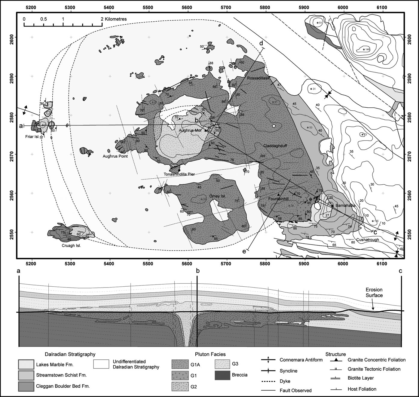
Figure 2 Geological map of the Omey Pluton showing facies distribution, internal structure and host rock structure, which is dominated by the D4 Connemara Anticline. Observed intrusive contacts are largely concordant and the intrusion is cross-cut by a series of NNW–SSE and E–W shear zones. Schematic cross-section of the Omey Pluton depicts lateral emplacement of magma along the axis of the Connemara Antiform.
2.1. Facies definition
Following Townend (Reference Townend1966), detailed remapping of the intrusion (Fig. 2) has resulted in considerable modifications in terms of facies definition, distribution and contact relationships. The Omey Pluton is a composite intrusion consisting of three main facies, G1, G2 and G3, previously termed the Omey Adamellite, the Aughrus More Adamellite and the Island Adamellite respectively (Townend Reference Townend1966). The Glassillaun Granodiorite, previously described as a sub-facies of G1 (Townend Reference Townend1966), is now recognised as a series of E–W-striking porphyritic microgranite dykes hosted within G1 and not a distinct facies of the pluton (Fig. 2). Townend (Reference Townend1966) also described the petrology and nature of lamprophyre and hornblende plagioclase porphyritic dykes which occur throughout the pluton, trending NNW–SSE or WSW–ENE and cross-cutting the granite and which, therefore, are <422 Ma.
Omey Island and a large proportion of the Aughrus Peninsula are composed of the G1 facies which makes up ∼75 % of the surface area of the pluton (Fig. 2). An array of small rocky sea stumps and islands lie 100–1000 m offshore to the W and N; the majority of these are also composed of G1. In the east, near Barnahallia Lough, G1A is defined by a notable increase in the abundance of 3-mm prismatic dark green hornblende (2 %). South of Aughrusbeg Lough ([055770, 258230]) and north of Tonashindilla Pier ([055790, 256650]), a circular body of G3 (diameter ∼1.2 km) forms the core of the Aughrus Peninsula and the highest point within the pluton, Aughrus More (146 m, [056475, 257626]). In the west, Cruagh Island and Friar Island are composed predominantly of G3. G2 is only found between G1 and G3. The largest exposures of G2 skirt around the NW and NE perimeter of the large exposure of G3 in the centre of the Aughrus Peninsula. The G2 facies is also present on the eastern tip of both Friar Island and Cruagh Island, and immediately north of Tonashindilla Pier (Fig. 2).
G1 is a medium-grained (8-mm) equigranular biotite hornblende monzogranite with rare 2 cm-long tabular phenocrysts of zoned plagioclase with seriticised calcic spikes (Fig. 3a, b). Rock mode is 30 % alkali feldspar, 34 % oligoclase-andesine, 30 % quartz, 3 % biotite, >2 % hornblende and 1 % accessories. Overall, this facies contains 72 SiO2 wt.% (Leggo et al. Reference Leggo, Compston and Leake1966). Typically, subhedral K-feldspar occurs as 10-mm crystals amongst slightly finer-grained quartz and biotite. Prismatic titanite and zircon, along with apatite and rutile, are common accessory minerals.
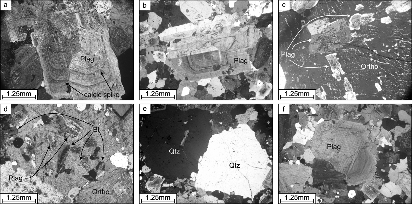
Figure 3 Characteristic petrographic features of facies G1 and G2. Seriticised calcic spikes within plagioclase (Plag) (a, b) and poikilitic K-feldspar (Ortho) crystals which exhibit inclusions of 0.5–2-mm quartz (Qtz), euhedral feldspar and oxides which accreted to, or nucleated on, the former outer margins of the phenocryst (c, d). G2 is distinguished from G1 by the presence of larger K-feldspars (c) and rounded quartz and plagioclase phenocrysts (e, f).
G2 is a medium-grained biotite hornblende monzogranite and is very similar to G1, having a mode of 29 % alkali feldspar, 33 % andesine, 34 % quartz, 3 % biotite and 1 % accessories. G2 is finer grained (∼6 mm), contains a lower abundance of hornblende (0–1 %) and exhibits very rare large phenocrysts of tabular K-feldspar up to 4 cm long. K-feldspar phenocrysts exhibit inclusions of quartz, biotite and plagioclase which are arranged and aligned in concentric zones within the crystal and against its faces via synneusis (Fig. 3c, d) (Vance Reference Vance1969). Quartz and feldspar commonly occur as rounded 6–8-mm grains (Fig. 3e, f), or as slightly elongate lobes which, with biotite, define subtle foliations when fabrics are present.
G3 is a medium- to fine-grained (∼2–6 mm) pink quartz-phyric monzogranite (Fig. 4). Accessory minerals include zircon, apatite, rutile and fluorite. Rock mode is 30 % K-feldspar, 32 % oligoclase, 35 % quartz, 2 % biotite, >1 % muscovite and >1 % accessories. Biotite is far less abundant, muscovite is present but rare and hornblende is absent; oligoclase is the dominant feldspar. Magnetite is present in lower abundances than those observed in earlier facies and a higher proportion of hematite is present (see ). This facies has a slightly higher SiO2 content (75 SiO2 wt.% (Leggo et al. Reference Leggo, Compston and Leake1966)) and fewer mafic minerals than G1 and G2, and is interpreted to represent a more evolved magma. The G3 facies characteristically exhibits a porphyritic texture defined by ≤15-mm tabular plagioclase and orthoclase (Fig. 4a, b) and ≤12-mm studs of anhedral or rounded quartz (Fig. 4c) set in a 2–5-mm monzogranite groundmass. Quartz phenocrysts exhibit minor undulose extinction and are approximately spherical. Fluorite associated with biotite layering on Cruagh Island is associated with a concentration of late-stage residual fluids rich in incompatible elements near the upper portions of the intrusion (Townend Reference Townend1966).
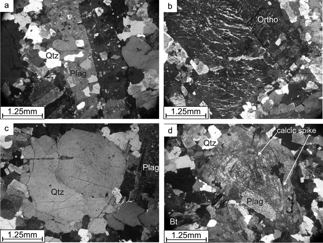
Figure 4 Characteristic petrographic features of G3. Porphyritic texture defined by ≤15-mm tabular plagioclase (Plag) and perthitic orthoclase (Ortho) (a, b) and ≤12-mm studs of anhedral or rounded quartz (Qtz) (c). Seriticised plagioclase is concentrated along calcic rich cores and calcic zones (d).
All facies plot towards the lower right of the monzogranite field, with a general trend from G1 to G3 becoming more quartz rich and less mafic. G1 and G2 are texturally and petrographically quite similar and are best distinguished by the presence of larger K-feldspars (Fig. 3c, d) and rounded quartz in G2 (Fig. 3e), and by a higher abundance of hornblende in G1. In both cases, prismatic green hornblende (∼2–4 mm) is typically fresh, while biotite (2–6 mm) is almost always euhedral (outside of shear zones) and extensively chloritised. Plagioclase is partially altered and commonly extensively replaced by sericite (Fig. 3a). A broad variety of zoning textures are noted in both sodic and potassium-rich feldspars, including oscillatory, normal and rarely boxy zoning (Figs 3a, b, 4d). K-feldspar regularly exhibits a dramatic micro-perthite texture with thin exsolution lamellae of albite flames, which may be parallel or irregularly orientated (Fig. 3c). Although rare, the conversion of orthoclase to microcline is recorded and spatially associated with minor wedged twins in plagioclase, kinking and smearing of biotite. These features are associated with syn-post emplacement strain, a topic discussed further below.
2.2. External contact relationships
The external contacts of the pluton are best described relative to the axial trace of the D4 Connemara Antiform (Fig. 2). South of the axial trace, from Barnahallia southwest to Fountainhill Beach ([058293, 255265]) and on Cruagh Island, the granite is in contact with the steeply inclined (∼80°) southward-dipping limb. North of the axial trace, from Barnahallia northwest to Rossadillask Beach ([058064, 259035]) the granite is in contact with the moderately inclined (∼55°) northward-dipping limb of the antiform. Within the proximity of the fold hinge, at Barnahallia in the east and on Friar Island in the west, the granite is in contact with the gently eastward-plunging (∼10°) axial trace.
Exposures of the western granite contact are limited to Cruagh Island and Friar Island (Fig. 2). On Cruagh Island, bedding dips steeply to the S (∼75°) and strikes WNW–ESE; while on Friar Island, bedding dips 10–25° to the E and strikes NNE–SSW. Thus, Cruagh Island and Friar Island are the offshore representations of the southern limb and fold hinge of the Connemara Antiform respectively, although Friar Island probably sits slightly south of the actual fold hinge. Host rock strata is currently stratigraphically unassigned (Leake & Tanner Reference Leake and Tanner1994; Long & McConnell Reference Long and McConnell1995), and is dominated by well-bedded pelites and psammites. Townend (Reference Townend1966) described the presence of a narrow quartzite unit and several quartz pebble bed horizons on Cruagh Island; an observation supported here. Similarities between the quartz conglomerate units observed here and observations made by Kilburn et al. (Reference Kilburn, Shackleton and Pitcher1965) at Cleggan Head ([059600, 259900]), suggest that the stratigraphic units on these Islands can be correlated with the Cleggan Boulder Bed Formation.
2.2.1. Southern limb
The granite contact extends along an E–W trajectory from Fountain Hill Beach ([058260, 255260]) to Grallaghan ([059060, 255270]), before swinging north toward Barnahallia (Fig. 2). Here, the Streamstown Schist Formation (Badley Reference Badley1976; Treloar Reference Treloar1977, Reference Treloar1982; Leake Reference Leake1986; Leake & Tanner Reference Leake and Tanner1994) forms the bounding country rock.
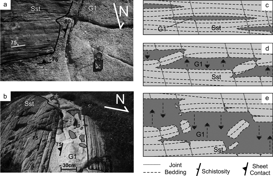
Immediately south of Fountain Hill (Fig. 2), a well-defined steeply-dipping contact parallels the southward-dipping southern limb of the Connemara Antiform. Several intrusions of G1 and G1A extend from the pluton up to 50 m into the host rock, exploiting joints and compositional layering that ultimately define sheets which are largely concordant to the folded symmetry of the country rock (Fig. 5a, b). Abrupt undulations in the granite–country rock contacts in this area occur parallel to regional joint sets (NNW–SSE, WNW–ESE), and illustrate that localised discordant injection of magma was facilitated by pre-existing joint planes. These features are regarded as broken bridges (Hutton Reference Hutton2009; Schofield et al. Reference Schofield, Heaton, Holford, Archer, Jackson and Jolley2012), where magma wedging preferentially exploits a vulnerable plane of weakness (bedding) and periodically sheets discordantly along a second pre-existing anisotropy (joints) (Fig. 5c–e).

Figure 5 The southeastern pluton contact is, overall, concordant to the Dalradian country rock which dips steeply to the south (a, b). The folded stratigraphy is locally transgressed by sheets of magma which exploit joints and stope off small fragments of schist and psammite (c–e); these features are regarded as broken bridges (as defined by Hutton Reference Hutton2009).
Owing to better topographic relief and exposure, the sheeted nature of the granite contact is best observed in Cruagh Island. Situated on the southern limb of the Connemara Antiform, steeply-dipping (70–60° S) units of the Cleggan Boulder Bed Formation are intruded by concordant sheets of G3 which penetrate up to 50m into the country rock. Some large (1–5 m) detached blocks are present and local subtle chilled margins are observed.
2.2.2. Northern limb
The Lakes Marble Formation, which lies stratigraphically above the Streamstown Schist Formation (Badley Reference Badley1976; Treloar Reference Treloar1977, Reference Treloar1982; Leake Reference Leake1986; Leake & Tanner Reference Leake and Tanner1994), is in contact with the granite along the northern limb of the Connemara Antiform (Fig. 2). This contact relationship is best exposed on the eastern end of Rossadillask Beach ([058060, 259000]), where a sharp contact between the host rock and G1 parallels the northward-dipping limb of the Connemara Antiform. As observed further south, granite sheets extend up to 30 m into the host rock and are parallel to or discordantly cross-cut bedding along joint planes. A minor reduction in grain size over a few centimetres is occasionally accompanied by subtle contact-parallel foliations (Fig. 2).
2.2.3. Along the fold hinge
At the southeast granite contact, the axis of the Connemara Antiform is located just north of Barnahallia Lough. At this locality, the inclination of country rock bedding is slightly steeper than that observed further east along the fold hinge (10–20° vs. 5–10°). This implies that bedding has been vertically displaced at this locality, probably as a result of bifurcation of the host rock during inflation of granite sheets as magma intruded. At Barnahallia Lough, the Streamstown Schist Formation lies in direct contact with the Omey Pluton, while to the NW at [059240, 256450] the same can be said for the Lakes Marble Formation (Fig. 2). It is, therefore, clear that intruding granite cross-cuts the Streamstown Schist Formation at map scale (Fig. 2).
Due to abrupt topographic relief and good exposure, the attitude of the pluton's contact near the fold hinge of the Connemara Antiform is best observed on Friar Island (Fig. 6). The majority of the granite bedrock is G3; however, a small proportion of the eastern bedrock is part of the G2 facies (Fig. 2). The contact between G2 and G3 on Friar Island is gradational. An overall E–W reduction in grain size occurs toward the country rock contact, along with increasing numbers of small (usually cm-m scale) stoped blocks. A weak contact parallel foliation, steeply inclined to the west, is recorded. In the western extremity of the island, the Cleggan Boulder Bed Formation dips gently (∼10°) to the east and strikes NNE–SSW. As observed at Barnahallia Lough in the east, the inclination of the country rock bedding increases slightly (∼15–20°) eastwards toward the granite contact. At the contact, sheets of granite, some over 4 m thick, are plainly observed intruding into and above units of the Cleggan Boulder Bed Formation and along inclined joints (Fig. 6a, b). A schematic vertical profile looking south shows bedded schists, overlain by a thick granite sill, then a 3-m sequence of schists which is again overlain by a granite sheet (Fig. 6c). This suggests that vertical displacement of the gently inclined country rock was achieved in order to accommodate the lateral intrusion and thickening of granite sheets.
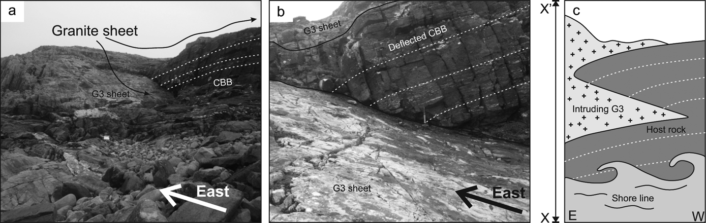
Figure 6 (a, b) Gently (10–20° E) eastward-inclined units of the Cleggan Boulder Bed Formation on Friar Island (see Fig. 2) show G3 intruded into and over the Cleggan Boulder Bed Formation, concordant to the primary schistosity and discordantly along inclined joint sets, along the fold axis of the Connemara Antiform. (c) A schematic section (looking south), depicting the perceived nature of the granite contact.
2.3. Internal contacts
Facies contacts are gradational, with the exception of some minor G3 sheets (∼1 m) that cross-cut G2 to the NE of Aughrus More; these show that G3 post-dates G2. The G1–G3 contact can be observed toward the western end of the Aughrus Peninsula at [055193, 257203], where a gradational contact over 1 m dips gently toward the west (<5°). Critically, G3 lies on top of G1, suggesting that G3 was emplaced sub-horizontally over G1. A gradational contact over ∼4 m is observed between G2 and G3 on Cruagh Island, Friar Island and near the summit of Aughrus More.
To the east and west of Aughrus More, mapped G1–G2 and G2–G3 contacts are approximately contour-parallel (Fig. 2), and so appear to be flat-lying. To the north and south of Aughrus More, mapped gradational contacts cross-cut topography and dip gently to the north and south, respectively. An ENE–WSW depression between Aughrus More and Aughrusbeg Lough reveal that G1–G2/G2–G3 contacts dip moderately to the west in this area.
2.4. Fabric development and sub-magmatic deformation
Characteristically weak, laterally discontinuous foliations defined by K-feldspar and euhedral platy biotite are observed sporadically within the pluton and define an overall concentric foliation (Fig. 2). This foliation is observed in G1 and G2, but not in G3. No systematic increase in fabric intensity is recorded in proximity to pluton margins. In thin section, quartz is typically anhedral and may exhibit weak undulose extinction. Chloritised biotite is euhedral, feldspars are idiomorphic and essentially unstrained, twinning in plagioclase is straight and only very rare examples of wedged twins are found. These features are characteristic of a dominantly magmatic or high-temperature weak sub-magmatic deformation, indicating that the observed fabrics formed prior to and during crystallisation (Vernon Reference Vernon2004; Passchier & Trouw Reference Passchier and Trouw2005). These foliations are interpreted as pluton inflation fabrics which resulted from the continued injection of magma into the site of emplacement.
Townend (Reference Townend1966) identified two distinctive fault sets (NNW–SSE and E–W) which cross-cut all pluton facies (Fig. 2). Remapping has identified several prominent NNW–SSE and E–W topographic lows that cut through Aughrus More, Omey Island and define lakes, scarps and the shape of the coastline about the Omey Pluton (Fig. 2). E–W-trending faults are denoted by undulations in topography and sometimes weak fabric development. Porphyritic microgranite sheets which show variably unchilled and chilled margins intrude these structures (as do Carboniferous dolerite dykes and the lamprophyre dykes described by Townend (Reference Townend1966)).
NNW–SSE faults are more prominent and are denoted by minor intrusions and ∼5 m-wide zones of moderate to strong sub-vertical NNW–SSE foliation (Fig. 7a). No consistent sense of shear has been identified along these faults. Marginal NNW–SSE sub-vertical foliations are defined by elongate quartz, aligned or smeared biotite and partially aligned feldspars, and intensify toward the centre of a shear zone. Brittle deformation occurs at the core of these structures and is expressed as intense, closely-spaced micro-fractures. In thin section, quartz ribbons are composed of multiple sub-grains which exhibit moderate undulose extinction, and biotite is variably kinked and smeared around euhedral feldspar phenocrysts (Fig. 7c). Feldspars incorporated into the foliation exhibit weak undulose extinction, orthoclase is sometimes partially converted to microcline and fractures are infilled with primary magmatic quartz (Fig. 7e, f). Such features are characteristic of sub-magmatic to solid-state deformation (Vernon Reference Vernon2004).
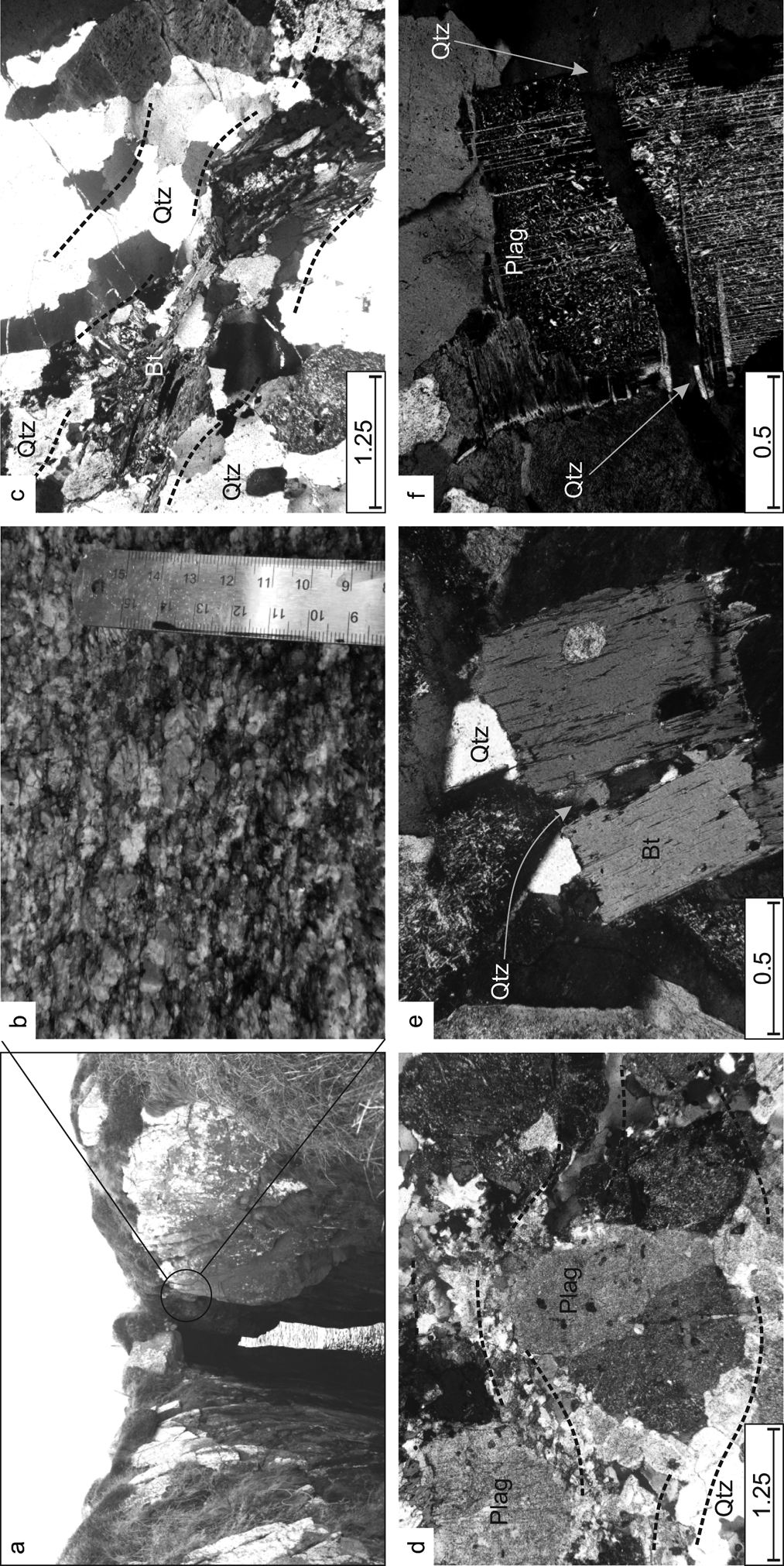
Figure 7 (a) A NNW–SSE shear zone from the northwestern portion of the Omey Pluton (see Fig. 2). (b) A moderate petrofabric within the shear zone parallels fine-scale micro fracturing, giving rise to a strong textural anisotropy. Petrographic observations show quartz ribbons (Qtz) and smeared biotite (Bt). (c) Marginal dynamic recrystallisation of plagioclase (Plag) along the foliation plane (d). Sub-magmatic deformation indicated by brittle fractures in biotite (e) and plagioclase (f), with primary quartz and biotite infill.
The field relationships and petrographic descriptions described show that the shear zones were established before the granite had cooled. These observations imply a concurrent relationship between shearing, which occurred mainly along NNW–SSE faults but also along E–W faults, and pluton construction.
3. Rock magnetic investigation
A total of 121 block samples were collected along an approximately evenly-spaced grid across the Omey Pluton, and between 7 and 22 (average 15) 21 mm x 25 mm right-cylindrical sub-specimens were analysed per sample site. A greater number of sites were sampled in localities close to facies contacts and shear zones. One in every twenty block samples were collected as duplicates as part of an AMS comparative study. A suite of rock magnetic experiments were also carried out to determine rock magnetic mineralogy, results and procedures of which are included in the online supplementary data section (see ).
3.1. AMS results
Results from a total of 113 out of 121 sample sites were accepted (Table 1); data from eight sites were rejected owing to localised hydrothermal overprinting. A summary of AMS data compiled from each facies is presented in Table 2. A review of the parameters used to evaluate the AMS tensor can be found in Tarling & Hrouda (Reference Tarling and Hrouda1993); here, the principal parameters used to characterise magnetic anisotropy are:
 $$\rm K_m = [K1 + K2 + K3] / 3$$
 $$\rm P_j = \{\exp \sqrt 2 [( \box 1 - \box )2 + ( \box 2 - \box ) 2 + ( \box 3 - \box ) 2]\}$$
 $$\rm T_j = [2 \box 2 - \box 1 - \box 3 ] / [\box 1 - \box 3 ]$$
 $$\rm H = [K1 - K3] / K_{mean}$$
where Km is the mean susceptibility, Pj and Tj are the Corrected Anisotropy Degree and the Shape Factor respectively (Jelinek Reference Jelinek1981) and H is the Total Anisotropy (Owens Reference Owens1974). The Tj parameter is used to distinguish oblate (0<Tj<1) from prolate fabrics (0>Tj>−1) (Jelinek Reference Jelinek1981). The shape of highly oblate AMS tensors (i.e., a magnetic foliation) can be visualised as a flattened ellipsoid in the K1–K2 plane (K3≪K2 ≈ K3). In this scenario, sub-samples return comparable K3 axes orientations (normal to the plane), while K1–K2 axes are distributed along the plane of flattening. Where the AMS tensor is highly prolate (K1≫K2≈K3), sub-specimen K1 susceptibility axes cluster and a girdle may be defined by K2 and K3 axes. Both a lineation and foliation can be determined where all principal susceptibility axes are well defined. If a composite fabric is present, or where an intermediate fabric occurs due to structural overprinting, the stereograph projection of the AMS tensor commonly shows broad 95 % confidence ellipses and a low degree of consistency between normalised and un-normalised stereograph tensor projections (Owens Reference Owens2000).
Table 1 Anisotropy of Magnetic Susceptibility data from the Omey Pluton, Western Ireland

Table 2 Summary of AMS results

AMS results yield mean susceptibility (Kmean) values that vary from 0.166×10⁻³ to 17.82×10⁻³ (SI units) across the pluton (mean=9.69×10⁻³±4.94×10⁻³). A sharp contrast in Kmean values is noted between earlier (G1=10.93×10⁻³; G2=9.29×10⁻³) and later (G3=1.94×10⁻³) facies (Table 2). A contour map of Kmean (Fig. 8a) reveals a low magnetic anomaly over the Aughrus Peninsula, Friar Island and Curagh Island which coincides with the mapped extent of the G3 facies. There is a similar, but less apparent, anomaly associated with the extent of the G2 facies. The corrected degree of anisotropy (Pj) varies between 1.01 and 1.07 (mean=1.04±0.013), and the overall Degree of Anisotropy (H) varies between 1.2 % and 10.1 % (mean=5.33 %±1.8 %). The maximum variance of mean Pj and H values between each facies is 0.01 % and 0.28 % respectively. As illustrated by a contour map of Pj (Fig. 8b), these data show that magnetic anisotropy does not systematically vary across facies contacts. The same observation is made for Tj values; G1 and G2 samples exhibit a spectrum of AMS ellipsoid shapes that range from well-defined oblate (−0.71), to tri-axial to strongly prolate (0.95) (Table 2). Samples taken from G3 return only weak to moderate oblate ellipsoids (Tj min=0.0024; max=0.016) and adjacent G2 and G1 sites also return similar shape and strength of anisotropy parameters. These data show that Kmean systematically fluctuates across facies contacts and is controlled by the relative concentration of magnetite in each facies, and that magnetic anisotropy is not inherent to granite facies.

Figure 8 (a) Contour map showing magnetic susceptibility (Kmean) remains ≥10–3 SI across the pluton. (b) A contour map of Corrected Degree of Anisotropy (Pj) shows no relationship between facies contacts and the degree of anisotropy.
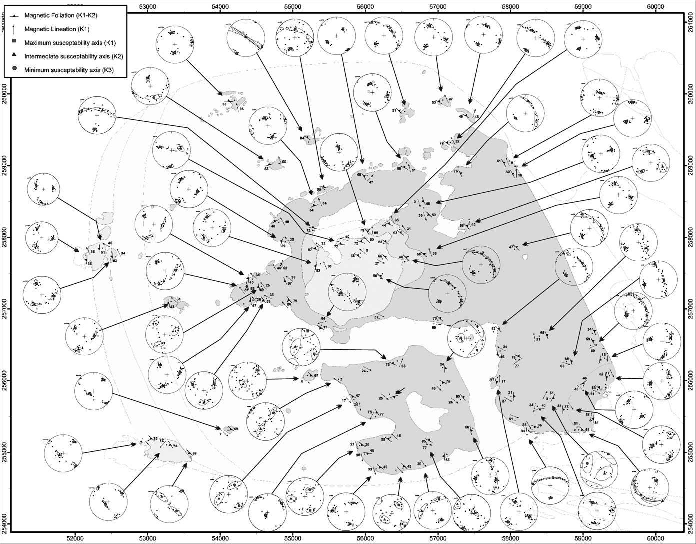
A map of the compiled AMS data, with representative stereographic projections of averaged AMS ellipsoids (95 % confidence ellipse), is presented in Figure 9. Either lineations or foliations are plotted from sites where strongly oblate or prolate tensors were detected; both symbols are used for sites where both a magnetic lineation and foliation were detected.

Figure 9 Results of AMS analysis with representative southern hemisphere projections of averaged AMS tensors. Each data point is plotted as a foliation, lineation or both, depending on calculated anisotropy values.
A summary of AMS data is presented in Figure 10. Two distinct AMS foliation patterns are identified (Fig. 10a). At the core of the intrusion, moderately-inclined, outward-dipping oblate fabrics define a strong concentric pattern. In the east of the pluton, where the granite is in contact with the Lakes Marble Formation and the Streamstown Schist Formation, foliations strike contact-parallel and are slightly oblique to the orientation of the host rock structure. Similarly, on Friar Island and Cruagh Island, magnetic foliations dip moderately outwards and are overall contact-parallel, but are often oblique to the local sheeted intrusions which intrude parallel to compositional layers in the folded host rock. Therefore, AMS data contrast field observations that clearly indicate that magma sheeted into the country rock along the folded limbs of the D4 Connemara Antiform and pre-granite regional joint sets. We interpret these magnetic foliations as inflation fabrics which represent the forceful input of magma into the pluton; an observation consistent with interpretations made on data derived from similar intrusions (Molyneux & Hutton Reference Molyneux and Hutton2000; Hutton & Siegesmund Reference Hutton and Siegesmund2001).
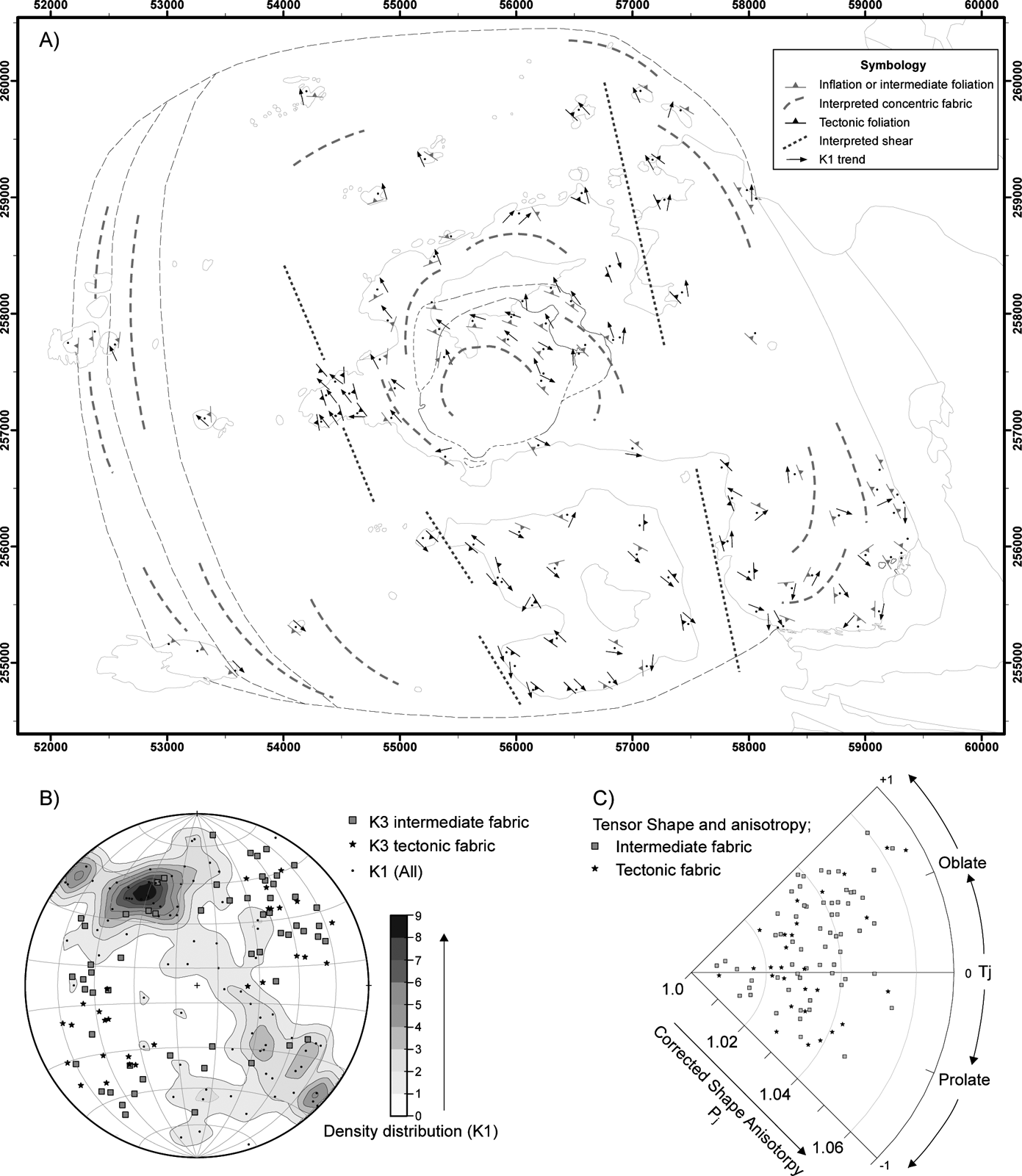
Figure 10 A summary of AMS data shows that the concentric foliation is cross-cut by NNW–SSE tectonic shear zones. (A) Two sets of fabrics are identified: (1) concentric foliations, associated with laccolith inflation; and (2) cross-cutting NNW–SSE foliations, attributed to submagmatic shearing along NNW–SSE shear zones (labelled ‘tectonic foliation’). (B) A polar plot of all AMS data points shows that K1 axes are aligned parallel to NNW–SSE axes. ‘Tectonic foliation’ K3 axes show a very consistent NNW–SSE subvertical foliation orientation. A much broader distribution of ‘inflation foliation’ K3 axes reflects the concentric fabric which was partially overprinted by tectonic shearing. (C) Polar plot of Tj vs Pj data shows the spectrum of AMS tensors detected across the pluton.
A different set of magnetic foliations are identified in close proximity to faults which have been identified by field mapping and petrographic observations (Fig. 10a). Magnetic foliations in these areas strike NNW–SSE, are discordant to internal and external pluton contacts, are steeply inclined and become more intense within the NNW–SSE fault zones. K1 vectors, i.e., magnetic lineations, maintain an overall NNW–SSE trend across the pluton and exhibit the highest anisotropy within the NNW–SSE fault zones. A stereographic projection of all AMS data shows that K3 axes from samples spatially associated with shear zones are tightly clustered in the ESE and WSW of the stereonet, while K3 axes sampled >250 m from the fault zones define a concentric pattern and are more evenly distributed (Fig. 10b). K1 axes throughout the pluton consistently plot along a NNW–SSE axis, regardless of proximity to faults (Fig. 10b).
Several examples of magnetic fabrics which bear no immediate relationship to either concentric or NNW–SSE fabrics are noted on Omey Island and immediately east in the Fountain Hill area (Fig. 9). The discordant nature of the mean tensor relative to geological contacts, the contrasting normalised and un-normalised AMS tensor projections, and the broad 95 % confidence ellipse (Owens Reference Owens2000), indicate that these are structurally intermediate fabrics and may be the result of interaction between shearing along less prominent E–W faults and inflation fabrics or NNW–SSE shear structures.
4. Discussion
New field observations place rigorous stratigraphical controls on the position of the Omey Pluton and, having established the orientation of the pluton's contacts, the overall symmetry of the intrusion can be constrained. The stratigraphy of the host rocks young to the E, the Cleggan Boulder Bed Formation being the oldest and the Lakes Marble Formation the youngest (Leake & Tanner Reference Leake and Tanner1994). The attitude of external contacts closely parallels the symmetry of the Connemara Antiform. Along the hinge, the granite contact dips gently to the E parallel to the plunge of the fold. The base of the sheet intrudes the Cleggan Boulder Bed Formation and a discordant roof is defined by the Streamstown Schist Formation and the Lakes Marble Formation. The northern and southern contacts are bound by, and are generally parallel to, the orientation of the fold limbs, as are internal facies boundaries. Thus, the architecture of this sheeted intrusion clearly pseudomorphs the symmetry of the Connemara Antiform into which it was emplaced, giving the body a phacolithic structure (Harker Reference Harker1909; Corry Reference Corry1988). However, as several examples of highly discordant external contacts have been described, the term ‘discordant phacolith’ is proposed to best describe the overall geometry (Fig. 11).
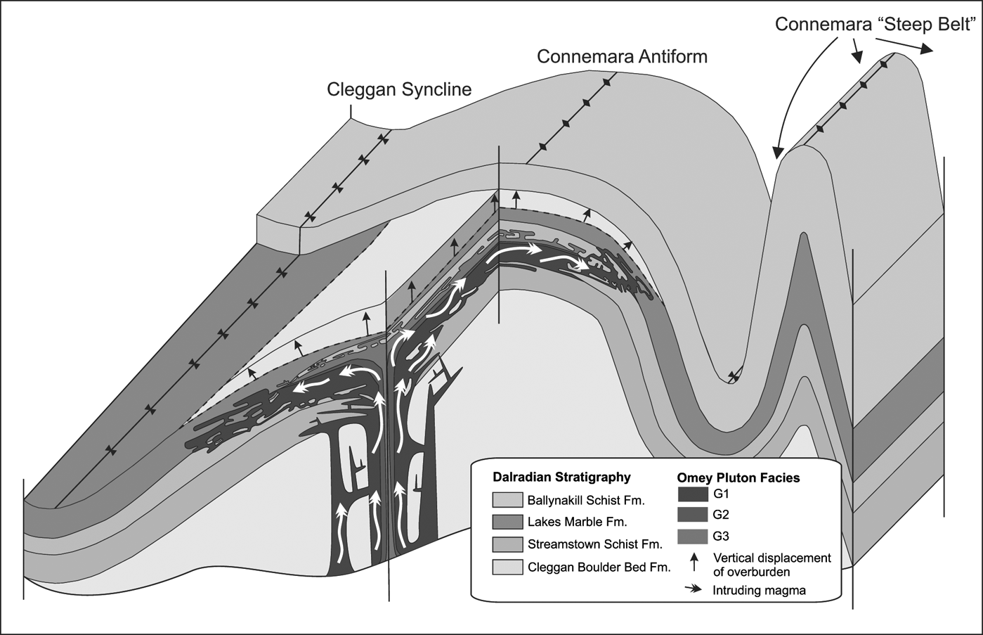
Figure 11 Block diagram depicting the overall symmetry of the Omey Pluton, which intruded along, and partially pseudomorphed, the Connemara Antiform.
4.1. Interplay between pluton ballooning and tectonic stretching fabrics
In apparently undeformed granitoid samples, where there is no textural evidence for tectonic deformation, magnetic lineations in igneous rocks are often taken to reliably indicate magma flow direction and are therefore used to model magma transport mechanisms (Petronis et al. Reference Petronis, Hacker, Holm, Geissman and Harlan2004; Stevenson et al. Reference Stevenson, Hutton and Price2008; Magee et al. Reference Magee, Stevenson, Driscoll and Petronis2012). Parés & van der Pluijm (Reference Parés and van der Pluijm2002) show that in rocks with a weak initial foliation, magnetic lineations are highly sensitive to the extension direction of the finite strain ellipsoid, and conclude that the final AMS tensor is largely dependent on the nature of an original fabric, rather than a direct reflection of the bulk strain ellipsoid. Accordingly, subtle primary flow fabrics in granitoid plutons are more susceptible to overprinting by later processes such as pluton inflation (Baxter et al. Reference Baxter, Graham, Feely, Reavy and Dewey2005; McCarthy et al. Reference McCarthy, Petronis, Reavy and Stevenson2015), tectonic stretching (Kligfield et al. Reference Kligfield, Owens and Lowrie1981; Alimohammadian et al. Reference Alimohammadian, Hamidi, Aslani, Shahidi, Cifelli and Mattei2013) and hydrothermal alteration (Just & Kontny Reference Just and Kontny2011; Valley et al. Reference Valley, Hanchar and Whitehouse2011). Petronis et al. (Reference Petronis, Driscoll, Stevenson and Reavy2012) interpret AMS data from the Ross of Mull Granite, Scotland, as a magma flow fabric which is partially overprinted by tectonic shearing because the magnetic lineation strikes parallel to well-known regional faults which were active during and after magma intrusion. Benn et al. (Reference Benn, Paterson, Lund, Pignotta and Kruse2001) exploit the sensitivity of the AMS technique and emphasises its use as a viable strain marker in syntectonic plutons, rather than as a magma flow indicator.
Concentric foliations, interpreted here as inflation fabrics, within the Omey Pluton are subtle (H most often <9 %), and thus are highly sensitive to tectonic stretching, particularly prior to full crystallisation of magma. Field observations and AMS data also identify two sets of shear zones (NNW–SSE and ENE–WSW), which are defined by: (i) abrupt breaks in topography; (ii) submagmatic foliations within 5 m-wide shear zones (later reactivated as faults); (iii) the NNW–SSE and E–W alignment of late Caledonian & Carboniferous mafic dykes within these shear zones; and (iv) the common alignment of AMS K1 axes that cross-cut all mapped facies contacts. The key observation made here is that the azimuth of AMS K1 axes is strikingly consistent across the entire pluton. Although the majority of these samples show an apparent lack of deformation, K1 reliably parallels apparently discrete and localised NNW–SSE shear zones. The detected lineations are therefore interpreted to be a product of tectonic stretching that was concurrent with, or followed immediately, after pluton inflation, and do not represent primary magma flow features, even in areas that appear to be undeformed.
4.2. Structural control over magma ascent
Prominent NNW–SSE shear zones within the Omey Pluton lie parallel to regional D5 faults that cross-cut the Connemara Metamorphic Complex and predate the Omey Pluton (Fig. 1; see also Leake & Tanner Reference Leake and Tanner1994). Similar NNW–SSE faults facilitated magma ascent during the construction of the Roundstone Pluton, thus showing that these faults were exploited as ascent conduits at ∼420 Ma. We argue that the suite of NNW–SSE faults that cross-cut the Omey Pluton are inherently related to those parallel structures that are observed in the country rock, with which these structures share a similar kinematic history.
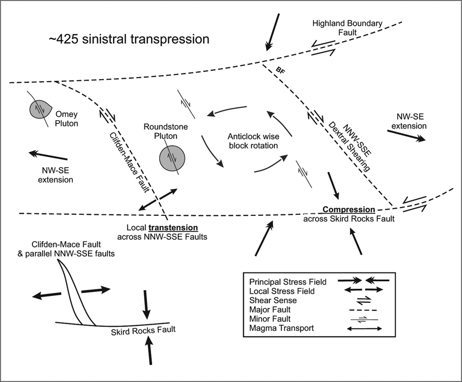
The concentric arrangement of granite facies around the centre of the pluton suggests centralised ascent, but sub-lateral sheeting of magma intruding from the east or west is also possible. The G3 facies occurs near the roof of the intrusion on Aughrus More and on the islands offshore to the west (Fig. 2). The fact that G3 does not occur adjacent to the fold axis in the east suggests that this facies did not intrude from the west but more likely from the centre of the pluton, and then sheeted laterally up-dip along the fold axis of the Connemara Antiform towards the west. In light of the temporal coincidence of magma transport to the site of emplacement and fault reactivation, we propose that ascent was achieved within a sub-vertical central conduit. In this scenario, the onset of regional sinistral transpression at ∼425 Ma caused vertical axis rotation of fault blocks bound by NNW–SSE and E–W faults that are observed in the field (Fig. 12). Dilation focused at fault junctions facilitated magma ascent, similar to the mechanisms envisaged by Jacques & Reavy (Reference Jacques and Reavy1994). At the site of emplacement, magma intruded laterally into the folded country rock along bedding and joint planes, to produce an overall discordant phacolith, and continued forceful injection of magma formed a subtle concentric pure shear inflation fabric. Both NNW–SSE and E–W faults were subsequently reactivated due to late Caledonian tectonism and, during the Carboniferous, as conduits for relatively minor intrusions.

Figure 12 A schematic model depicting the interplay between regional stress, local structures and magma ascent. Anticlockwise vertical axis block rotation, triggered by regional transpression, leads to dilation along NNW–SSE conduits.
5. Regional significance
Earlier investigations on the structural controls over the GGC, and the influence of regional stress have focused exclusively on the Main Batholith; a consensus that magma was emplaced at ∼400 Ma along a zone of dilation within the Skird Rocks Fault due to regional sinistral transtension has been reached (Desouky et al. Reference Desouky, Feely and Mohr1996; Baxter et al. Reference Baxter, Graham, Feely, Reavy and Dewey2005; Leake Reference Leake2008; Feely et al. Reference Feely, Selby, Conliffe and Judge2007). However, the structural relationship between the Earlier Plutons and the Main Batholith has not, as of yet, been considered.
We propose that anticlockwise vertical axis rotation of fault blocks within the Connemara Metamorphic Complex during regional transpression controlled the siting of the Earlier Plutons along NNW–SSE faults. Regional far field stress evolved from orogenic orthogonal shortening to sinistral oblique compressive stress between 430 Ma and 425 Ma (Dewey & Strachan Reference Dewey and Strachan2003). In western Ireland, the Connemara terrane represents a deformation zone bound by the Highland Boundary Fault (HBF) and the Skird Rocks Fault (SRF), along which sinistral transpressive strike slip occurred. The deformation zone, bound by these faults, was structurally heterogeneous and decoupled along strike due to strain partitioning along NNW–SSE faults (e.g. the Clifton–Mace Fault and the Barna Fault (Fig. 12)). Regional transpression promoted anti-clockwise rotation of the terrane block bound by the Clifton Mace Fault, the Barna Fault, the Skird Rocks Fault and the Highland Boundary Fault (or splay of) (Fig. 12). Thus, local dextral transtensive stress is predicted along NNW–SSE faults, while the HBF and SRF were in the compressive field. As a consequence, NNW–SSE faults presented a favourable migration conduit for ascending magma throughout regional transpression. The Omey and Roundstone Plutons were emplaced during this time and are cited over NNW–SSE faults known to have been active at this time. We suggest that these supplied magma to the upper crust and that emplacement was controlled by local factors, namely the symmetry of the Connemara Antiform (this study) and the Mannin Thrust (McCarthy et al. Reference McCarthy, Petronis, Reavy and Stevenson2015), respectively.
In contrast, the overall shape and internal architecture of the Main Batholith is dominated by WSW–ENE trending structures (Desouky et al. Reference Desouky, Feely and Mohr1996; Crowley & Feely Reference Crowley and Feely1997; Baxter et al. Reference Baxter, Graham, Feely, Reavy and Dewey2005; Leake Reference Leake2008). This observation suggests that magma ascent was controlled by the Skird Rocks Fault, which is predicted to have undergone net extension during regional transtension, thus making it a more favourable magma transport conduit during orogenic collapse at ∼400 Ma.
6. Conclusions and further work
The control of large faults on magma transport in the crust is a long-standing concept (Richey Reference Richey1932; Pitcher & Bussell Reference Pitcher and Bussell1977). The interplay between such structures and evolving regional stress fields during magmatism has been demonstrated in several case studies (Jacques & Reavy Reference Jacques and Reavy1994; Hutton & Alsop Reference Hutton and Alsop1996; Brown & Solar Reference Brown and Solar1998; Pe-Piper et al. Reference Pe-Piper, Piper and Matarangas2002). For example, research in Donegal (Hutton & Alsop Reference Hutton and Alsop1996; Stevenson et al. Reference Stevenson, Hutton and Price2008) has shown how the construction of the Donegal Batholith was ultimately controlled by the interactions of two major crustal structures, the Donegal Lineament and the Main Donegal Shear Zone. It now appears that a similar situation pertains to the Galway Granite Complex, whereby the orientation of fault systems relative to the regional stress field during magmatism dictated which structures were utilised as magma conduits during pluton construction.
The current work shows that the oldest known pluton of the GGC (Omey) was controlled by a NNW–SSE fault system and that it shares certain structural relationships with the Roundstone Pluton which intruded at approximately the same time, at ∼420 Ma (McCarthy et al. Reference McCarthy, Petronis, Reavy and Stevenson2015). In contrast, the Main Batholith intruded into the WNW–ESE Skird Rocks Fault much later, at 400 Ma. This implies that a kinematic transition, i.e., transpression to transtension, occurred during construction of the complex, which led to structures in different orientations being exploited as magma conduits over time. If correct, this hypothesis predicts that plutons of a similar age which were intruded into comparable kinematic regimes will exhibit predictable structural controls.
7. Acknowledgements
We would like to thank the local community at Claddaghduff, Co. Galway, and Ruth and Jon Hunt for their continued hospitality. Martin Feely is thanked for helpful discussions. WMcC acknowledges receipt of an Irish Research Council for Science Engineering and Technology (IRCSET) grant and a National University of Ireland Travelling Studentship for postgraduate study at University College Cork.
8. Appendix – Supplementary Magnetic Data
The supplementary magnetic data, describing in detail the investigation of rock magnetic properties for AMS interpretation, are published with the online version of this paper. This is hosted by the Cambridge Journals Online (CJO) service and can be viewed at http://journals.cambridge.org/tre