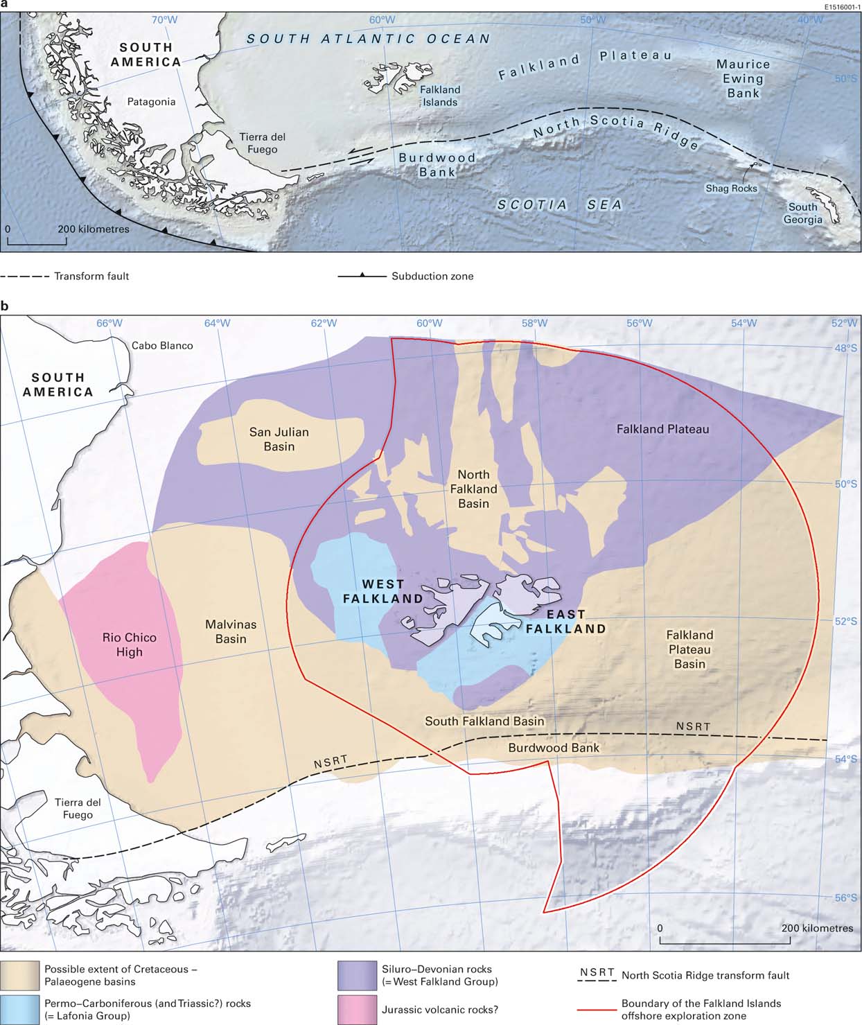
The Falkland Islands lie in the SW part of the South Atlantic Ocean, centred around 52° S. 60° W., about 500 km east of the South American mainland. They occupy the western end of the Falkland Plateau (Fig. 1a), a rectilinear, relatively shallow water (<2,500 m approximately) bathymetric feature that extends eastwards from the South American continental shelf. Two large islands, East and West Falkland, are surrounded by a score of substantial subsidiary islands and hundreds of smaller islands, rocks and reefs, which together comprise a total land area of just over 12,000 km2. The archipelago is a British Overseas Territory, but is also claimed by Argentina as Las Islas Malvinas.

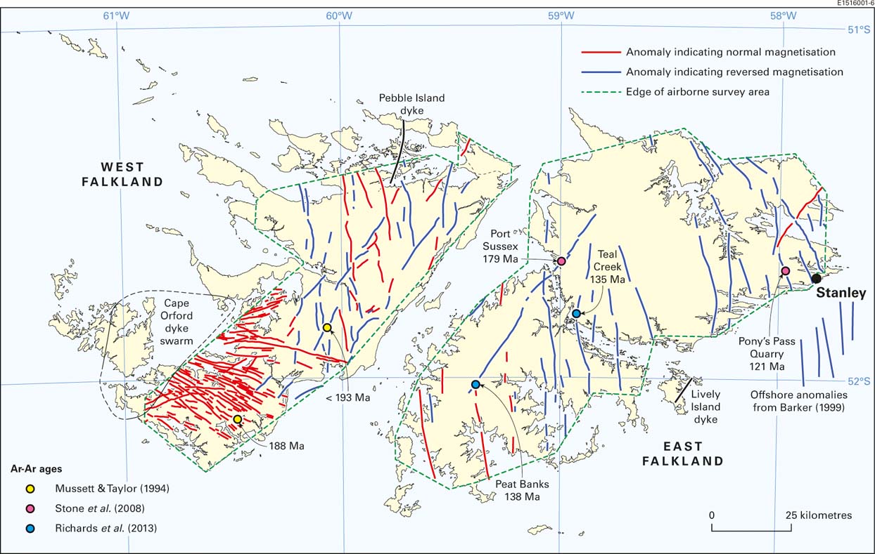
Figure 1 The regional setting of the Falkland Islands in the South Atlantic Ocean: (a) the Falkland Islands in relation to southern South America and the North Scotia Ridge; (b) the Falkland Islands and the locations of their surrounding Mesozoic to Palaeogene sedimentary basins.
Early geological exploration of the islands was a piecemeal affair, carried out mainly by scientists attached to passing expeditions whose main focus was elsewhere. Those studies, and an assessment in the early 1920s of potential geological resources, were hampered by the lack of accurate topographical base maps, which only became available in 1961. A photogeological interpretation followed (Greenway Reference Greenway1972), but a modern, field-based geological survey was not accomplished until the 1990s, with the map and geological report arising from that exercise (Aldiss & Edwards Reference Aldiss and Edwards1998, Reference Aldiss and Edwards1999) providing the first comprehensive account of the onshore geology.
Offshore sedimentary basins surround the Falklands archipelago (Fig. 1b) and were intermittently investigated by reconnaissance seismic surveys from the 1950s to the 1970s. These were seen as primarily academic projects, but paved the way for more determined commercial hydrocarbon exploration from the 1980s onwards. Richards et al. (Reference Richards, Gatliff, Quinn, Williamson, Fannin, Storey, King and Livermore1996) provided a regional overview of the offshore basins' geology.
This review paper considers both the onshore geology of the Falkland Islands and the offshore geology of the sedimentary basins that surround them, placing the region's geological development into the context of Gondwana and its break-up. References to the geological time scale and chronostratigraphical divisions follow Gradstein et al. (Reference Gradstein, Ogg, Schmitz and Ogg2012). For the onshore area, the lithostratigraphical terminology formalised by Aldiss & Edwards (Reference Aldiss and Edwards1998, Reference Aldiss and Edwards1999) will be used throughout, despite any anachronisms that arise from reference to older literature. As a precursor to the detailed discussion of Falklands geology, and as an introduction to the nomenclature, a summary of the geological history now follows.
1. An introductory geological summary
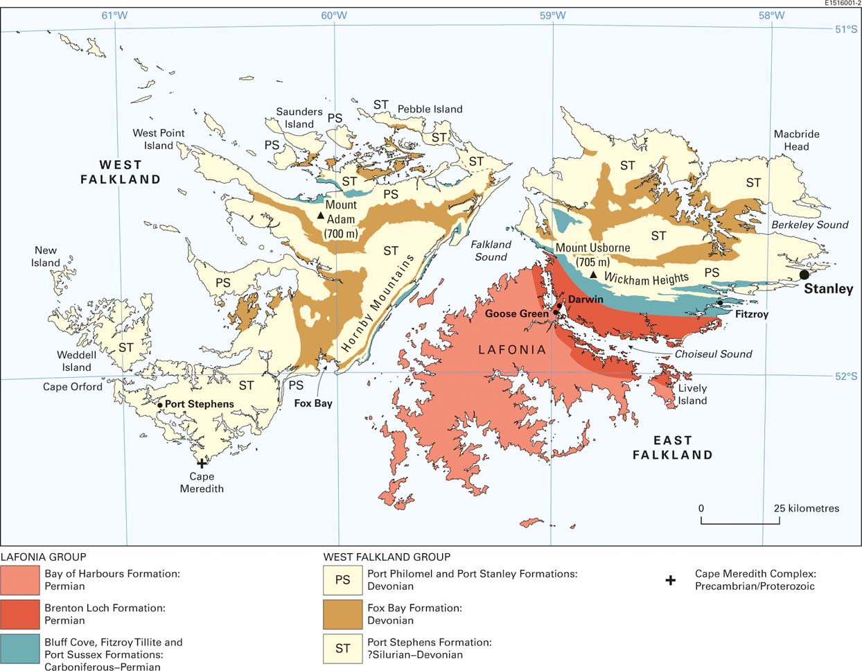
The onshore geology is illustrated in Figure 2, with lithostratigraphical data and the regional geological history summarised in Figure 3. The oldest Falkland Islands rocks are the ca 1,000 million-year-old granite and gneiss of the Proterozoic Cape Meredith Complex, which has a restricted coastal outcrop on the southernmost point of West Falkland. This ‘basement’ complex is unconformably overlain by the West Falkland Group, a thick succession of fluvial to neritic and shallow marine, quartzite, sandstone and mudstone, ranging in age from Silurian to Devonian. The outcrop of the West Falkland Group covers most of West Falkland and the northern part of East Falkland. In the southern part of East Falkland, a younger succession of strata, the Lafonia Group, has near its base (the northern margin of its outcrop on Fig. 2) an Early Permian glacigenic diamictite, which is followed in upward succession by a thick development of Permian, deltaic and pro-delta basinal (probably lacustrine) sandstone and mudstone. The Permian strata were deposited in a sedimentary basin formed ahead of a south-verging, fold and thrust belt that concurrently deformed the Silurian to Devonian succession, before advancing into the older Permian beds. The Proterozoic complex and all of the Palaeozoic sedimentary rocks are cut by swarms of Early Jurassic or Early Cretaceous dolerite dykes.

Figure 2 An outline of the onshore, bedrock geology of the Falkland Islands (lithostratigraphical outcrop excluding dykes) after Aldiss & Edwards (Reference Aldiss and Edwards1998).
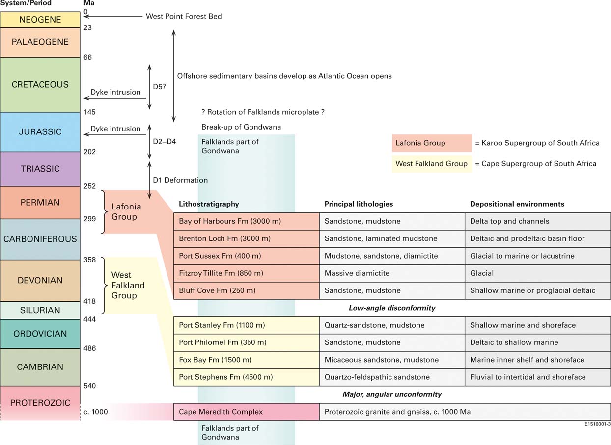
Figure 3 A summary of the geological history of the Falkland Islands and their offshore environs. For the onshore lithostratigraphy, the stratigraphical thicknesses shown are for East Falkland; the West Falkland succession is significantly thinner. For details of representative lithostratigraphical specimens held by the British Geological Survey, see Stone (Reference Stone2014).
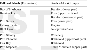
With the exception of the Early Cretaceous intrusive dyke swarm, the geological development of the Falkland Islands took place in the context of the Gondwana supercontinent. Comparisons with what were then contiguous sectors of Gondwana, now preserved in South Africa, South America and Antarctica, are important, and will be addressed later in this review (see especially section 7). Correlations with South Africa have been particularly influential, with the West Falkland and Lafonia groups bearing striking similarity, respectively, to successions seen in the Cape Fold Belt and Karoo Basin. Deformational histories are also similar, and the interpretation of this regional association is crucial to the still-controversial plate tectonic history of the Falkland Islands (see especially section 10). Do they form part of a continental promontory fixed in relation to the South American mainland (the ‘rigid’ model), or are they part of a microplate that moved independently during the break-up of Gondwana (the ‘rotational’ model)? The latter, rotational interpretation (favoured by the author) can be traced back to the prescient proposals of Adie (Reference Adie1952a).
Figure 4 shows a reconstruction of Gondwana incorporating rotation of a Falklands microplate back to a position off the SE coast of South Africa, based on illustrations in Dalziel et al. (Reference Dalziel, Lawver, Norton and Gahagan2013) and Storey et al. (Reference Storey, Vaughan and Riley2013). It must be stressed that the underlying premise is not universally accepted, but these authors, and others before them, accept a 180° clockwise rotation of the Falklands microplate: 150° during the Late Jurassic fragmentation of Gondwana and a further 30° during opening of the South Atlantic Ocean from the Early Cretaceous onwards, after the microplate's transfer to the incipient South American continental margin. This view is supported largely by evidence derived from onshore geology; the contrary ‘rigid’ interpretation is supported largely by evidence derived from offshore geology. The resulting geological dichotomy provides a recurring theme which will be developed and discussed as this review progresses, but at this introductory stage it is sufficient to note the general concepts and uncertainties.

Figure 4 A representation of the Gondwana continental configuration in the Early Jurassic, immediately prior to the commencement of its break-up, simplified after Dalziel et al. (Reference Dalziel, Lawver, Norton and Gahagan2013, fig. 3) and with igneous provinces from Storey et al. (Reference Storey, Vaughan and Riley2013, fig. 1).
The Early Cretaceous dykes link the onshore geology with that of the offshore basins, originating through crustal extension as the South Atlantic Ocean opened following the initial break-up of Gondwana. The principal sedimentary basins around the Falklands (Fig. 1b) have recently been the subject of extensive seismic surveys and a number of exploration wells have been drilled, mostly in the North Falkland Basin. With only a few exceptions, the data collected are held on a confidential basis by the companies concerned and are commercially sensitive. Nevertheless, the general basin stratigraphy has been confirmed as a Late Jurassic and younger sedimentary succession that lays either on strata equivalent to the onshore West Falkland and Lafonia groups, or on possible Jurassic volcanic rocks (pyroclastics and/or lavas). The structural controls on basin formation vary considerably, as will be discussed in section 8.
Across much of the Falkland Islands, the bedrock is covered by extensive and varied Quaternary deposits. Evidence for glaciation is restricted to small cirques and associated moraine on the highest hills, but in places on the lower ground, spectacular periglacial blockfields (known locally as ‘stone runs’) are developed. The widespread peat accumulations commonly range up to about 10 m in thickness. Coastal features are contradictory, with the drowned ria-type coastline replete with raised beaches and wave-cut rock terraces. The details of the Quaternary history, although offering much of interest, are beyond the scope of this review.
2. Geological pioneers
The first substantive geological observations in the Falkland Islands were made by Charles Darwin during two visits to Berkeley Sound, East Falkland, by HMS Beagle in 1833 and 1834. Darwin described a folded and cleaved succession of quartzite, sandstone and mudstone, from which he recovered Devonian fossils, mostly brachiopods (Darwin Reference Darwin1846; Morris & Sharpe Reference Morris and Sharpe1846). In a footnote to his 1846 paper, Darwin recorded the dolerite dyke swarm that had been discovered and reported to him by Bartholomew Sulivan in 1845 (Stone & Rushton Reference Stone and Rushton2013). Fossils, again mostly brachiopods, were also acquired in 1842 during the James Clark Ross Erebus & Terror expedition, in 1876 during the Challenger expedition (Etheridge Reference Etheridge1885), and in 1903 during the Scottish National Antarctic (Scotia) Expedition (Newton Reference Newton1906), but these added little to the overall geological appreciation. More substantial progress was made by geologists accompanying two Swedish expeditions that visited the Falkland Islands: the Swedish South Polar Expedition (1901–1903) and the Swedish Magellanic Expedition (1907–1909). Reporting after these ventures, Andersson (Reference Andersson1907) and Halle (Reference Halle1911) recorded the presence on West Falkland of the ‘basement’ granite–gneiss complex, expanded the range of the Devonian shelly fauna, clarified the Palaeozoic stratigraphy and extended it into the Permian with the discovery of a fossil Glossopteris flora, and described a glacigenic unit (now the Fitzroy Tillite Formation) that Halle correctly correlated with the Upper Carboniferous to Lower Permian Dwyka tillites of South Africa. This regional correlation was seized upon by Wegener (Reference Wegener1922, Reference Wegener1929) in the 3rd and 4th editions of his book Die Ehtstehung der Kontinente und Ozeane as evidence for his ‘displacement theory’ of continental drift. The association of Falklands and South African geology had been noted earlier on palaeontological grounds, and with evident surprise, by Sharpe & Salter (Reference Sharpe and Salter1856), who were familiar with Darwin's collection, and was reiterated by Clarke (Reference Clarke1913) in his seminal work on the Devonian ‘Malvinokaffric’ fauna of South America and the Falkland Islands. All of these lines of evidence were pulled together by Du Toit (Reference Du Toit1927, Reference Du Toit1937), whose important influence on the continental drift debate and the associated South Atlantic correlations will be examined in more detail in section 7.1.
Although Halle (Reference Halle1911) had included an outline geological map of the Falkland in his report, the first attempt at comprehensive geological mapping was by Baker (Reference Baker1922, Reference Baker1924), the ‘Government Geologist’ from 1920 to 1922. Baker was principally concerned with economic geology and whilst his prospecting was unsuccessful (as was an earlier investigation carried out on behalf of the Salvesen Whaling Company (Stone & Faithfull (Reference Stone and Faithfull2013)), his work laid the foundations for the modern interpretation of Falklands geology and he notably utilised Wegener's recently formulated ideas of continental drift to explain the geological similarities with South Africa. Baker's geological map was at a relatively small scale and was only available as a fold-out figure within his relatively obscure 1924 report. Nevertheless, for fifty years it remained the definitive representation of Falkland Islands geology, until the publication by the British Antarctic Survey of a photogeological interpretation by Greenway (Reference Greenway1972), who utilised much of Baker's (Reference Baker1924) lithostratigraphy. The aerial photography utilised by Greenway had been flown in 1956 and formed the basis of the first detailed topographical maps of the islands, a series published in 1961 at a scale of 1:50 000 by the British Government's Department of Overseas Surveys.
Greenway did not visit the Falkland Islands and, prior to her interpretation, Baker's map and cross-section had been reproduced by Adie (Reference Adie and Teichert1952b) and in a Spanish-language review by Borrello (Reference Borrello1963), published in Argentina. Adie spent some time in the Falkland Islands and was impressed by the close similarity of the geological succession to that of his native South Africa. He developed a model of Gondwana in which the Falkland Islands originated in close proximity to the Eastern Cape (Adie Reference Adie1952a). Borrello did not visit the Falkland Islands but, nevertheless, emphasised perceived geological correlations with South America, from which ‘Las Malvinas’ were, he deduced, a continental promontory. A regional review by Mitchell-Thomé (Reference Mitchell-Thomé1970) also reproduced Baker's geological map and cross-sections and gave equal weight to the seemingly incompatible regional correlations of Adie (with South Africa) and Borrello (with South America), whilst lamenting the lack of comprehensive field data.
Offshore, seismic refraction profiles had been shot across the Falklands area in the late 1950s, as part of an academic research project based at the Lamont-Doherty Geological Observatory (now Earth Observatory) of Columbia University in the City of New York, USA. These were followed by more seismic research studies, focused not on hydrocarbon potential but on the fundamental nature of the Falkland Plateau. This phase of activity culminated in 1974 in the drilling of three boreholes on the Maurice Ewing Bank, some 600 km to the east of the Falkland Islands (Fig. 1), during Leg 36 of the international Deep Sea Drilling Project (DSDP). One of the boreholes (DSDP 330) proved a basement of crystalline metamorphic rocks (Tarney Reference Tarney1977) similar to some of the lithologies seen in the Cape Meredith Complex (but also with some significant differences); also proved was the existence of a potential oil source rock. The latter discovery encouraged more commercial interest and during the 1977–78 austral summer two speculative, regional seismic surveys were shot around the Falkland Islands. Data from these surveys remained proprietary and were not made publically available.
3. Political complications and economic development
Despite the obstacles to cooperation introduced by the long-standing Argentine territorial claim to Las Malvinas, relations were sufficiently amicable between 1970 and 1980 for several Argentinean geologists to work in the Falkland Islands, concentrating on local specialist issues rather than on regional survey. Their contributions have been summarised by Aldiss & Edwards (Reference Aldiss and Edwards1999, p. 5). This involvement came to an abrupt end in 1982, but as Argentina has vigorously reasserted the claim, a parallel topographical nomenclature has been created (and continues to grow). Inevitably, the alternative gazetteer (Permanent Committee on Geographical Names 2006) has influenced the lithostratigraphical terminology applied, albeit inconsistently, in the Argentine literature (e.g., Turner Reference Turner1980; Limarino et al. Reference Limarino, Massabie, Rossello, López Gamundi, Page, Jalfín and Caminos1999; Mendía et al. Reference Mendía, Anselmi and Negro2008). In the Malvinas archipelago, the two main islands become Gran Malvina (West Falkland) and Isla Soledad (East Falkland) and these names are applied to the West Falkland and Lafonia groups respectively; the Cape Meredith Complex is usually renamed Complejo Cabo Belgrano. With Lafonia released, that name then sometimes displaces Fitzroy in a Lafonia (or Lafonian) Tillite Formation, though the tillite (diamictite) does not crop out in Lafonia sensu stricto. During the brief Argentine military occupation of the islands in 1982, the town of Stanley (founded in 1843) was renamed Puerto Argentino. The usage has been maintained in Argentine literature and, accordingly, the Port Stanley Formation is commonly (though not invariably) disavowed; Formación Caleta Shag (from Shag Cove, a location in Gran Malvina) being preferred, after Scasso & Mendía (Reference Scasso and Mendía1985). In defining their terminology, Scasso & Mendía pointed out the inappropriateness of Formación Monte María that had been introduced by Borrello (Reference Borrello1963) to incorporate both the Port Stanley and Port Philomel formations, but which was erroneously named after an area that subsequently proved to be part of the Port Stephens Formation outcrop (Aldiss & Edwards Reference Aldiss and Edwards1999, pp 27 & 29). The inevitable confusion arising from these and many other alternative usages seems likely to continue.
At the larger, plate tectonic scale, there is also an alternative terminology. In many modern interpretations, the Falkland Islands continental area is regarded as a separate Falklands microplate (see especially sections 7 and 10, below), but Ben-Avraham et al. (Reference Ben-Avraham, Hartnady and Malan1993) referred to the same concept as the Lafonia microplate. Some authors have maintained this usage (e.g., Dalziel et al. (Reference Dalziel, Lawver, Norton and Gahagan2013)), perhaps as a way of avoiding the Falklands/Malvinas sensitivities. That may not help. Lafonia was named after Samuel Fisher Lafone, an English businessman based in Montevideo (Uruguay), who acquired rights to the eponymous territory in 1846 (Cawkell Reference Cawkell2001, pp 75–77).
Given the state of knowledge in 1982, it seems unlikely that offshore hydrocarbons potential figured very highly in the calculations of either the Argentine or British governments when, in that year, the Falkland Islands were invaded and temporarily occupied by an Argentine military force. Thereafter, it was not until the early 1990s that renewed interest in the offshore potential led to the acquisition of more speculative seismic data to both the north and south of the archipelago. In 1996, the first Production Licences were awarded for acreage to the north, in the North Falkland Basin, and initiated the more focused exploration programmes that continue today with, in 2015, the third offshore drilling campaign.
The 1990s also saw a marked increase in onshore geological activity. A comprehensive, field-based geological survey was commissioned by the Falkland Islands Government (Reference AldissAldiss 1997), leading to the Aldiss & Edwards (Reference Aldiss and Edwards1998, Reference Aldiss and Edwards1999) map (solid geology published in two sheets at a scale of 1: 250 000) and accompanying report. At around the same time, and stimulated by the offshore activity, a number of speculative consultancy group investigations and university-based academic projects were undertaken. Economic interest was not restricted to the offshore areas, and systematic onshore mineral exploration, with gold as the primary target, culminated between about 2005 and 2007 in an extensive borehole programme. Although this programme was economically unsuccessful, the data generated by the onshore exploration, including the results of an aeromagnetic survey, proved invaluable in terms of the broader geological interpretation.
4. The onshore geological succession
4.1. Cape Meredith Complex
The Proterozoic rocks of the Cape Meredith Complex have a narrow coastal outcrop extending for about 5 km around the southernmost point of West Falkland (Fig. 2). They were discovered in 1902 by the Swedish geologist J. G. Andersson, who spent time in the Falkland Islands whilst waiting to rendezvous with the Antarctic, the ship supporting the 1901–1903 Swedish Antarctic Expedition. The specimens that he collected at the time were lost a year later when the Antarctic was crushed in pack-ice and sank. Andersson (Reference Andersson1907) noted the presence of gneiss intruded by granite, and schist cut by dykes, with all lithologies and fabrics terminated abruptly at an unconformity subjacent to overlying sandstone. Baker (Reference Baker1924) re-examined the rocks in more detail and gave the first descriptions (and illustrations) based on microscope petrography. He noted schist cut by granite, pegmatite and lamprophyre dykes, all covered unconformably by the base of the overlying sedimentary succession (Port Stephens Formation) and described the igneous-metamorphic assemblage as the Cape Meredith Series. Adie (Reference Adie and Teichert1952b) subsequently modified the name to Cape Meredith Complex in a review of Falkland Islands stratigraphy.
From their lithological character, Andersson, Baker and Adie had presumed, quite reasonably, that the Cape Meredith rocks were of Archaean age. The first radiometric dating results to be published, by Cingolani & Varela (Reference Cingolani and Varela1976), gave Late Proterozoic ages: amphibolites of about 1100 Ma (K–Ar); granite and gneiss of about 980 Ma (Rb–Sr). Cingolani & Varela also dated lamprophyre dykes intruded into the metamorphic rocks, but cut by the unconformity within the approximate range of 500–550 Ma (K–Ar). The Cape Meredith Complex had been previously sampled for dating purposes in 1969, by geologists from the British Antarctic Survey. The results (Rex & Tanner Reference Rex, Tanner and Craddock1982) – ages of about 950–980 Ma (K–Ar on biotite and hornblende from gneiss) – were presented at a scientific conference in 1977, but the conference proceedings were slow to appear. Like those of Cingolani & Varela, the Rex & Tanner dates had relatively large errors.
A more recent assessment of the Cape Meredith Complex was provided by Thomas et al. (Reference Thomas, Jacobs, Weber and Ricci1997) based on detailed mapping. They defined a Big Cape Formation of interlayered amphibolite, felsic gneiss and biotite–hornblende gneiss, intruded by three generations of granitoids; a granodiorite and granite, both strongly foliated and veined by a later granite with no tectonic fabric. Age data arising from this survey were presented by Jacobs et al. (Reference Jacobs, Thomas, Armstrong and Henjes-Kunst1999). From the felsic gneiss of the Big Cape Formation, a U–Pb zircon age of 1118±8 Ma was interpreted as showing the time of eruption of a rhyolitic protolith; Ar/Ar hornblende ages of 1009±14 Ma and 1015±6 Ma were obtained from the amphibolite. The three phases of granitoid intrusion spanned an age range of about 1090–1000 Ma. The overall interpretation was of Mesoproterozoic generation of the Cape Meredith Complex, with relatively rapid cooling thereafter, and no evidence of any subsequent thermal overprinting.
A range of dykes cut the metamorphic and plutonic components of the Cape Meredith Complex, as noted by the early investigators, and these were described in detail by Thistlewood et al. (Reference Thistlewood, Leat, Millar, Storey and Vaughan1997). Four dyke groups were identified, the first three of which were intruded prior to uplift, erosion and deposition of the unconformably overlying sedimentary succession. The relative ages of the two oldest dyke groups have been disputed (Thomas et al. Reference Thomas, Henjes-Kunst and Jacobs1998) but, as described by Thistlewood et al. (Reference Thistlewood, Leat, Millar, Storey and Vaughan1997), the earliest dykes are diverse lamprophyres (spessartite, minette and vogesite) showing varying degrees of alteration. The most reliable age obtained, 523±9 Ma (K–Ar, biotite from vogesite) is within the range reported from the same dyke suite (and probably the same dyke) by Cingolani & Varela (Reference Cingolani and Varela1976). Two younger, but still pre-unconformity, dyke groups were of differing doleritic compositions and gave poorly defined Ordovician and Silurian ages respectively. The Silurian age of 422±39 Ma provided a broad constraint on the maximum age of the unconformably overlying sedimentary strata. The fourth of the dyke groups defined by Thistlewood et al. (Reference Thistlewood, Leat, Millar, Storey and Vaughan1997) comprised dolerites that cut across the unconformity and were members of the Early Jurassic swarm seen widely in adjacent parts of West Falkland. The Mesozoic dyke swarms will be considered later in this review in section 6.
4.2. West Falkland Group
The older of the two Falkland Islands sedimentary successions was originally assigned the informal names Devono-Carboniferous Series (Baker Reference Baker1924) or the Devono-Carboniferous Group (Reference GreenwayGreenway 1972). Borrello (Reference Borrello1963) had introduced the term Sistema de Gran Malvina, which transformed, via the Argentine literature, into the Gran Malvina Group of Marshall (Reference Marshall1994a) and, finally, using the name for the same geographical area that is preferred by its inhabitants, the West Falkland Group of Aldiss & Edwards (Reference Aldiss and Edwards1998, Reference Aldiss and Edwards1999). There are four component formations (Figs 2, 3).
4.2.1. Port Stephens Formation
Forming the lowermost division of the West Falkland Group, the Port Stephens Formation comprises as much as 4,500 m of quartzitic and quartzo-feldspathic sandstone in East Falkland (where the base is not seen), but only about 2,500 m are present in West Falkland. Some of the sandstone is coarse-grained and grades up to granule to pebble conglomerate with, in West Falkland, a thin basal unit of red mudstone overlying the Cape Meredith Complex. Coarse-grained sandstone dominates the middle part of the succession, with fine-grained sandstone more abundant in the upper and lower parts; cross-bedding and bioturbation are widespread. Detailed descriptions have been provided by Aldiss & Edwards (Reference Aldiss and Edwards1999) and Hunter & Lomas (Reference Hunter and Lomas2003), who define, respectively, either six or five members, the difference caused by the appearance of an additional (fine-grained) basal member in East Falkland. The Formation has an extensive outcrop in West Falkland and the northern half of East Falkland (Fig. 2).
The depositional environment was fluvial to neritic and shallow marine. The detailed study by Hunter & Lomas (Reference Hunter and Lomas2003) identified a range of lithofacies and ichnofaunal assemblages that, together, indicated terrestrial and shallow-marine deposition on an extensive, gently shelving alluvial to coastal plain, deepening to the present-day NE; palaeocurrent flow was also predominantly towards the NE. Regional subsidence was gentle and long-lived, with sediment (including abundant well-rounded grains reminiscent of aeolian deposits) supplied from a mature, continental source. Nevertheless, differences in the heavy mineral content of sandstones from the different members suggest that there was some provenance variation (Aldiss & Edwards Reference Aldiss and Edwards1999). The vertical variation in lithofacies was thought to arise from a transgressive–regressive–transgressive palaeoenvironmental pattern, with most of the sediment accumulating during the regressive phase.
Apart from the extensive array of trace fossils, the Port Stephens Formation is unfossiliferous in terms of macrofauna, but Lochkovian (earliest Devonian) spores have been recovered from the upper part of the formation (Marshall Reference Marshall, Becker, Königshof and Brett2016). The depositional age of the lower part of the formation is most likely to be Silurian, with the maximum age poorly constrained by the probably Silurian date (422±39 Ma) obtained from a pre-unconformity dyke in the underlying Cape Meredith Complex. The minimum age is constrained by the Early Devonian (Pragian to Emsian) age of fossils from the overlying Fox Bay Formation.
One remote inlier of likely Port Stephens Formation strata must also be noted and its presence requires some explanation. About 50 km south of the southernmost point on East Falkland, the small and isolated Beauchêne Island is most probably composed of Port Stephens Formation quartzite and quartz-sandstone (Edwards Reference Edwards1997). The occurrence lies within the southernmost West Falkland Group outcrop shown in Fig. 1b, to the south of the younger strata in the Lafonia Group outcrop and to the north of the Mesozoic, South Falkland Basin. Its elevation may be the result of regional tectonics associated with the south-verging Falklands fold and thrust belt, to be discussed further in section 5.2. Alternatively, as will be discussed in section 8.2, uplift may have been driven by tectonic processes further south. There, the South Falkland Basin is a north-verging foreland basin formed at the sinistral transpressive boundary between the South American and Scotia plates. The uplift of the West Falkland Group to create the Beauchêne Island inlier could be part of the forebulge development associated with that basin.
4.2.2. Fox Bay and Port Philomel formations
Conformably overlying the Port Stephens Formation, although with a probably transgressive base, is a succession of yellow-brown, fine- to medium-grained subarkosic and micaceous sandstone, siltstone and mudstone, which together comprise the Fox Bay Formation. Its outcrop coincides with much of the lower-lying ground in West Falkland and the northern half of East Falkland (Fig. 2). The Formation is about 650 m thick in the south of West Falkland, but this figure increases to the north and east to a maximum of approximately 1,500 m in parts of East Falkland. Detailed descriptions were given by Marshall (Reference Marshall1994a) and by Aldiss & Edwards (Reference Aldiss and Edwards1999), who separated a local member at the top of the succession in parts of West Falkland. Bioturbation is widespread and a varied shelly fauna is locally abundant.
A shallow marine depositional environment is likely for most of the succession, ranging from inner shelf to shoreface. Widespread hummocky-cross-stratification demonstrates deposition within the reach of storm wave-base, whilst plane- and cross-bedded sandstones suggest relatively high-energy transport and deposition, perhaps with a tidal influence. Lithofacies distribution indicates a deepening of the depositional environment towards the north and east, but superimposed on this is a series of at least four shallowing-upwards sedimentary cycles defined by the proportion of sandstone to mudstone, more of the latter being characteristic of the deeper-water accumulations. Some mudstone beds carry carbonate-rich and/or pyritic concretions, usually nucleated on fossil material.
The ‘Malvinokaffric’ fossil fauna from the Fox Bay Formation is well known and is generally regarded as Emsian (Early Devonian) in age, although palynomorph assemblages show that the overall age range of the formation is late Pragian to early Eifelian (Marshall Reference Marshall, Becker, Königshof and Brett2016). A characteristic population of brachiopods and trilobites (calmoniids and homalonotids) is commonly accompanied by bivalves, crinoids and gastropods and, more rarely, by orthocones, conularia, bryozoa and tentaculitids. Descriptions have been published of several collections acquired by passing expeditions in the 19th and early 20th centuries (see section 2 and Stone & Rushton Reference Stone and Rushton2012), but the outstanding contribution from that period was by Clarke (Reference Clarke1913). Further additions were made by Baker (Reference Baker1924). Clarke's calmoniid trilobite material was reassessed by Edgecombe (Reference Edgecombe1994), and the recent faunal list compiled by Aldiss & Edwards (Reference Aldiss and Edwards1999), based on modern taxonomy, comprised 39 taxa, including 12 brachiopods, six trilobites and 11 bivalves. This total has been subsequently extended by the discovery of additional trilobite species (Carvalho Reference Carvalho2006) and rare acanthodian fish spines (Maisey et al. Reference Maisey, Borghi and Carvalho2002) during a collecting expedition to the islands from the American Museum of Natural History in 2000, and a starfish-like ophiuroid (Rushton & Stone Reference Rushton and Stone2011; Hunter et al. Reference Hunter, Rushton, Stone, Kido, Waters, Ariunchimeg, Sersmaa, Da Silva, Whalen, Suttner and Königshof2014). Examples of the Fox Bay Formation fauna are shown in Figure 5.
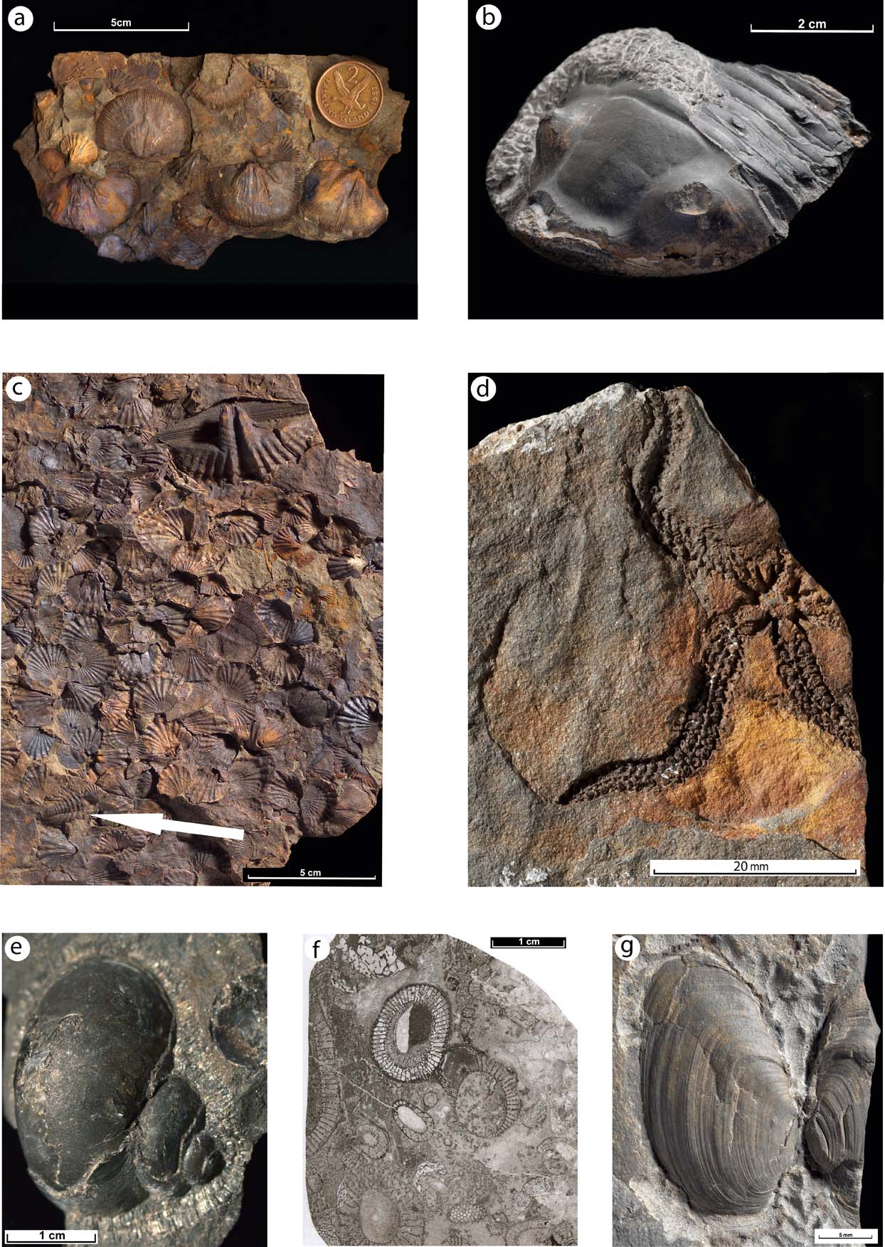
Figure 5 Fossils from the Falkland Islands. (a–e) examples of the Devonian Malvinokaffric fauna from the Fox Bay Formation: (a) brachiopods: the larger shells are Schellwienella sulivani; they are internal moulds of the pedicle valve and show fine radial ribbing. The smaller shells are Australocoelia palmata; the paler specimen (on the left) is an internal mould of a pedicle valve, but there are fragments of brachial valves and external moulds, all of which show the coarse ribbing. Fox Bay, West Falkland. BGS image P100659; (b) trilobite: an oblique anterior view of a cephalon (head-shield) of the Homalonotid Burmeisteria herschelii, with part of the thorax attached. The animal's right eye is elevated, well seen on the left side of the figure, but the left eye has broken off. Pebble Island, West Falkland. BGS image P618374; (c) brachiopods and a trilobite: a variety of internal and external moulds of the small, coarsely-ribbed Australocoelia palmata. The much larger shell is the pedicle valve of Australospirifer hawkinsii, preserved as an internal mould. Note also the small pygidium (tail-piece, arrowed) of a calmoniid trilobite. Saddle Quarry, West Falkland. BGS image P549540 (detail); (d) starfish-like ophiuroid or ‘brittle-star’ preserved as a natural impression (an external mould) of the under-side. Fish Creek, East Falkland. BGS image P727089; (e) A gastropod with a large part of the shell broken away, showing a natural mould of the body-chamber. The upper part retains the shell-material and is encrusted by a bryozoan colony. Pebble Island, West Falkland. BGS image P511902. (f) Cambrian archeaocyaths from a limestone clast in the Permian Fitzroy Tillite Formation: a thin section from a limestone clast showing several species, including Metacyathellus lairdi (left and centre) and scattered ?Erismacoscinus sp. and Spirocyathella cf. cooperi (bottom left). Hill Cove, West Falkland. BGS image P537735. (g) Conjoined shells of a Permian bivalve from the Brenton Loch Formation. Palaeanodonta sp. aff. P. dubia, showing the growth-lines. Rory's Creek, East Falkland. BGS image P573118.
The top of the Fox Bay Formation is transitional into the overlying Port Philomel Formation, a division recognised by Baker (Reference Baker1924) and by Aldiss & Edwards (Reference Aldiss and Edwards1998, Reference Aldiss and Edwards1999), but which is sometimes included within the Fox Bay Formation (e.g., Marshall Reference Marshall1994a), since the respective lithologies are broadly similar: soft, yellow-brown sandstone with associated siltstone and mudstone. The Port Philomel Formation as defined by Aldiss & Edwards thickens eastwards from approximately 150 m to 350 m. It contains a higher proportion of medium-grained sandstone, disposed in a wider range of bed-forms – planar- and flaser-lamination, trough-, wedge- and tabular-cross-bedding, climbing ripples, channel-fill features and fining-upwards cycles – than is seen in the underlying Fox Bay Formation. But the most characteristic traits, although not strictly lithostratigraphic, are the widespread presence of fossil lycopsoid plant material and the absence of a marine shelly fauna. A broadly deltaic depositional environment seems most likely.
Some of the plant fossils collected by Halle and Baker, from what would now be regarded as the Port Philomel Formation, were described by Seward & Walton (Reference Seward and Walton1923) as being most probably of Mid Devonian age. This was confirmed when another of Halle's specimens that was subsequently re-examined proved to contain Givetian palynomorphs, in addition to the plant macrofossils (Cramer & Cramer Reference Cramer and Cramer1972). Subsequent palynological work by Marshall (Reference Marshall, Becker, Königshof and Brett2016) demonstrated the presence of early Givetian assemblages. Very rare and fragmentary fish (placoderm) remains have also been reported (Maisey et al. Reference Maisey, Borghi and Carvalho2002).
4.2.3. Port Stanley Formation
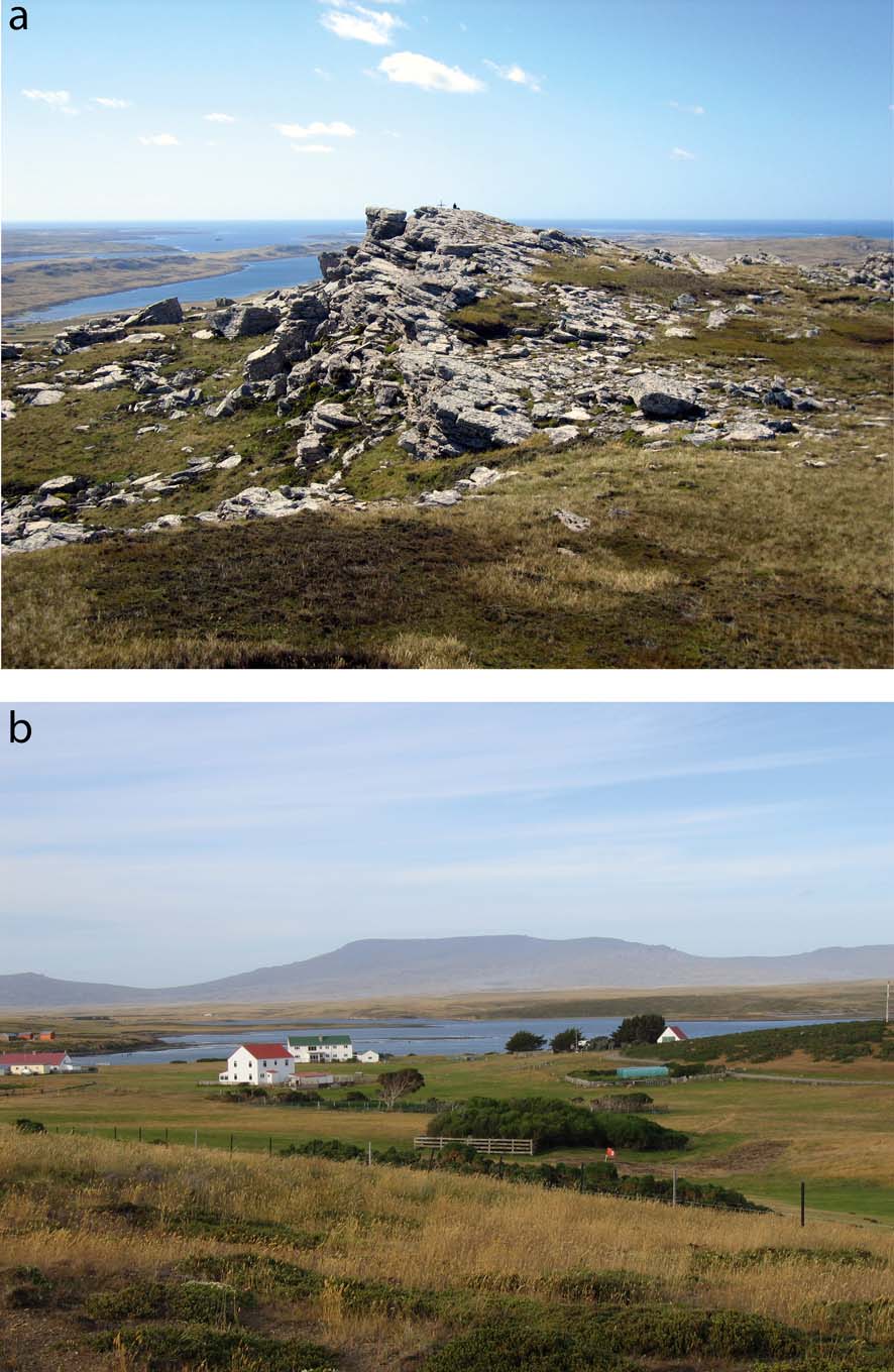
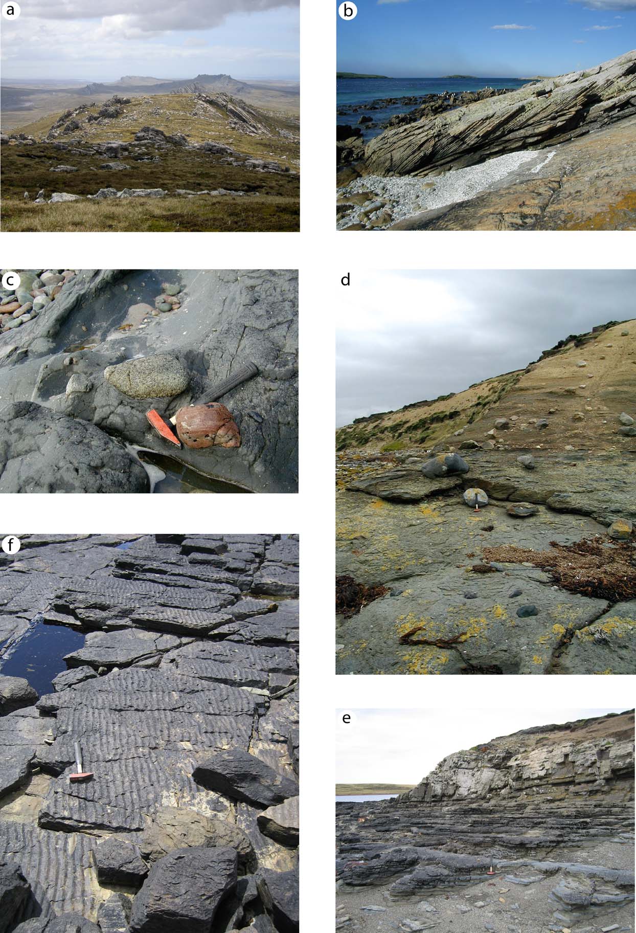
The highest division of the West Falkland Group, the Port Stanley Formation, is characterised by hard, pale grey quartzite and medium-grained quartz-rich sandstone, interbedded with siltstone and mudstone. Most noticeably in West Falkland, the base is locally erosive into the underlying Port Philomel Formation, but this is not thought to represent a significant time gap. The Port Stanley Formation is about 500 m thick in West Falkland, where the outcrop forms the high ground adjacent to the north and east coasts, but thickens eastward to about 1,100 m in East Falkland. There, the outcrop forms the E–W zone of high ground in the centre of the island, the Wickham Heights and its eastward extension towards Stanley (Fig. 6a). At the western end of the Wickham Heights lies Mt Usborne (705 m), the highest point in East Falkland (Fig. 6b), whilst the Port Stanley Formation also forms the highest point in West Falkland, Mt Adam (700 m), in the NW part of that island (Fig. 2). A detailed description is provided by Aldiss & Edwards (Reference Aldiss and Edwards1999), although the Port Stanley Formation remains less well documented than the lower part of the West Falkland Group.

Figure 6 The E–W mountainous ridge of central East Falkland, created by the outcrop of the Port Stanley Formation: (a) quartzite crags at Tumbledown, overlooking Port Stanley. The figure standing on the summit provides a sense of scale. BGS image P587736; (b) the Wickham Heights and Mount Usborne, at 705 m the highest point in the Falkland Islands, seen from Darwin. The subdued foreground topography is characteristic of the Lafonia Group outcrop. BGS image P696257.
Quartz-rich, coarse to medium-grained sandstone and quartzite are the most commonly exposed lithologies (Fig. 7a), but that probably gives a false impression of their proportion in the formation as a whole. Interbeds of siltstone and mudstone are common, and some of the mudstones are highly carbonaceous. Many of the sandstone beds show large-scale planar or tabular cross-bedding (Fig. 7b), which is slumped or overturned in places, whilst other beds are thick, exceptionally up to 3 m, and plane-bedded; some contain a scattering of small mud flakes. The depositional environment was most probably a marine shoreface with tidal channels, although Meadows (Reference Meadows, Cameron, Bate and Clure1999) regarded the Port Stanley Formation as accumulating in a probably braided, fluvial channel system.

Figure 7 Examples of characteristic Falkland Islands lithologies: (a) typical exposure of the hard quartzites of the Port Stanley Formation, seen here looking east towards Stanley at the eastern end of the Wickham Heights, East Falkland. BGS image P696221; (b) tabular cross bedding, a widespread feature in the Port Stanley Formation, seen on the Cape Pembroke promontory to the east of Stanley, East Falkland; (c) quartzite and granitic clasts in diamictite of the Fitzroy Tillite Formation near Hill Cove, on the north coast of the West Falkland mainland to the north of Mount Adam; (d) a Fitzroy Tillite Formation (diamictite) section carrying a sub-horizontal fabric, seen near Hill Cove, on the north coast of the West Falkland mainland to the north of Mount Adam. The hammer rests against a cobble of archaeocyathan limestone eroded from the cliff; (e) thinly interbedded sandstone and mudstone of the Brenton Loch Formation at Salinas Beach, 3km west of Darwin, East Falkland. BGS image P696250; (f) Ripple-bedded sandstone of the Bay of Harbours Formation at New Haven, 20 km NW of Darwin, East Falkland. BGS image P696250.
Lycopsoid plant stem impressions and carbonaceous leaf traces are locally present, particularly in the lower part of the Port Stanley Formation, but no faunal macrofossils have been reported and even trace fossils are extremely rare. Palynology studies by Marshall (Reference Marshall1994a, Reference Marshall, Becker, Königshof and Brett2016) determined a Famennian (Late Devonian) age near the top of the formation, whilst a maximum age is defined by the Givetian age of the underlying Port Philomel Formation.
4.3. Lafonia Group
Halle (Reference Halle1911) described the younger of the two Falkland Islands sedimentary successions as the Lafonian Series, which was then divided by Baker (Reference Baker1924) into an Upper and a Lower Lafonian Series. These names were carried forward by Greenway (Reference Greenway1972) as upper and lower groups within a Lafonian Supergroup but, meanwhile, Borrello (Reference Borrello1963) had changed the name to Sistema de la Isla Soledad; Borrello's terminology became the Grupo Isla Soleded in subsequent Argentine literature.
Aldiss & Edwards (Reference Aldiss and Edwards1998, Reference Aldiss and Edwards1999) re-established Halle's original concept as the Lafonia Group, with five component formations (Fig. 3). Detailed descriptions have been provided by Aldiss & Edwards (Reference Aldiss and Edwards1999) and Trewin et al. (Reference Trewin, Macdonald and Thomas2002).
4.3.1. Bluff Cove, Fitzroy Tillite and Port Sussex formations
These three formations are equivalent to the Lower Lafonian Series of Baker (Reference Baker1924) and the Lower Lafonian Group of Greenway (Reference Greenway1972). The lowest of the three, the Bluff Cove Formation, occurs only in East Falkland, where it disconformably overlies the Port Stanley Formation. It comprises about 200 m of mostly fine-grained, quartzo-feldspathic sandstone containing white mica, laminated siltstone and mudstone, locally affected by soft-sediment deformation. Adie (Reference Adie and Teichert1952b) and Dawson (Reference Dawson1967) regarded the strata as proglacial deposits, either glacimarine or glacilacustrine, and reported dropstones in the upper part of the formation which increased in number upwards to merge with the overlying Fitzroy Tillite Formation. In their formal definition of the Bluff Cove Formation, Aldiss & Edwards (Reference Aldiss and Edwards1999) thought that the dropstone-bearing beds were more appropriately included in the overlying Tillite Formation.
No macrofossils have been recovered from the Bluff Cove Formation, and both bioturbation and trace fossils are rare. The age would seem to be constrained by scarce spores and pollen from a mudstone, reported by Aldiss & Edwards (Reference Aldiss and Edwards1999) as being “Late Carboniferous or younger”; conversely, Meadows (Reference Meadows, Cameron, Bate and Clure1999) reported the presence of Devonian palynomorphs. A Carboniferous (or Early Permian) age would be more compatible with the regional associations, so perhaps the Devonian material was derived and recycled from the underlying West Falkland Group. In dating the onset of glaciation, it is also worth noting the diamictite-filled sedimentary dykes cutting down into Port Stephens Formation strata that were reported from West Falkland by Hyam et al. (Reference Hyam, Marshall and Sanderson1997) and which contain mid-Carboniferous (Late Viséan to Early Namurian) palynomorphs. If these sedimentary dykes were formed during a widespread mid-Carboniferous glacial episode, as seems likely, any other resulting deposits were removed by the subsequent Early Permian glaciation that deposited the Fitzroy Tillite Formation (described below).
In East Falkland, the Bluff Cove Formation appears to be conformably succeeded by the glacigenic diamictite of the Fitzroy Tillite Formation. In West Falkland, the diamictite rests unconformably on Port Stanley Formation strata, with an angular discordance of up to 20° (Frakes & Crowell Reference Frakes and Crowell1967). The thickness of the deposit decreases westwards across East Falkland from about 900 m to 750 m; about 650 m is present on the east coast of West Falkland but farther west, the thickness may increase to about 850 m (Aldiss & Edwards Reference Aldiss and Edwards1999). The nature of the deposit was first recognised by Halle (Reference Halle1911), more information was provided by Baker (Reference Baker1924) and an in-depth study was made by Frakes & Crowell (Reference Frakes and Crowell1967). These authors, and several others subsequently, used ‘Lafonian’ as the geographical descriptor of a tillite/diamictite lithostratigraphical division but, as pointed out by Aldiss & Edwards (Reference Aldiss and Edwards1999), the unit has no outcrop in that part of East Falkland known as Lafonia (Fig. 2). Accordingly, Aldiss & Edwards defined their equivalent Fitzroy Tillite Formation.
The East Falkland outcrops are of a massive or weakly thick-bedded, sandy diamictite containing a variety of matrix-supported erratic clasts, most commonly of quartzite or granitic lithologies. A slightly different lithofacies is seen in West Falkland where, in the west, the diamictite is more friable, contains a greater range of clasts in terms of both size and composition (Fig. 7c), and locally contains linear sandstone bodies. A sporadically-developed, sub-horizontal fabric (Fig. 7d) is probably a relict of an original stratification, modified by sub-glacial deformation. On the east coast of West Falkland, a 5–6 m thickness of laminated sandstone and siltstone, with sporadic dropstones, was noted by Frakes & Crowell (Reference Frakes and Crowell1967) to be interbedded within the massive diamictite; they ascribed patchy reddening to contemporary subaerial weathering. This laminated unit was subsequently separated as a distinct member by Aldiss & Edwards (Reference Aldiss and Edwards1999), who concluded that it was of Sakmarian age, and by Meadows (Reference Meadows, Cameron, Bate and Clure1999).
All those who have investigated the diamictite have noted that the range of clast lithologies includes many that can be related to local sources within the Cape Meredith Complex or the West Falkland Group, but also includes a proportion of entirely exotic lithologies; e.g., garnet-gneiss, various porphyritic igneous rocks, quartz-pebble conglomerate and limestone. A recent discovery of fossiliferous limestone containing an Early Cambrian archaeocyath-trilobite fauna (Figs 5f, 7d) (Stone & Thomson Reference Stone, Thomson, Vaughan, Leat and Pankhurst2005; Stone et al. Reference Stone, Thomson and Rushton2012) has significance for regional correlation and palaeogeography and will be returned to in section 7, below.
Frakes & Crowell (Reference Frakes and Crowell1967) distinguished three diamictite lithofacies related to different depositional environments. In the west, they proposed a grounded ice-sheet with the deposits incorporating the linear sand bodies thought to have originated as eskers. Farther east in West Falkland, a more disturbed lithofacies was related to slumping and remobilisation on a submarine slope, whilst the massive diamictite of East Falkland was regarded as a glacimarine deposit. The glacimarine aspect was disputed by Aldiss & Edwards (Reference Aldiss and Edwards1999), who considered the features shown to be more characteristic of subglacial till deposited directly from the base of an ice sheet. They noted in particular the absence of dewatering structures and the random orientation of clast axes. A similar conclusion was reached by Horan (Reference Horan2015) after a detailed study of the diamictite made possible by the recovery of borehole core generated between 2005 and 2007 during a mineral exploration project (Stone Reference Stone2011; Stone & Horan Reference Stone and Horan2016). Horan reiterated the absence of any signs of reworking by water movement, provided more detail on the random orientation of clasts, and noted local glacitectonic structures. The latter included brecciation and fissility, planar shearing and rotational deformation fabrics around clasts.
The regional association of the Fitzroy Tillite Formation with other deposits of the Carboniferous to Permian glaciation of southern Gondwana has been long recognised (e.g., Halle Reference Halle1911; Baker Reference Baker1924). By comparison with the correlative Dwyka Group tillites of South Africa (more on this in section 7, below), Aldiss & Edwards (Reference Aldiss and Edwards1999) concluded that deposition of the Fitzroy Tillite was largely Early Permian in age, mostly Asselian and Sakmarian but possibly continuing into the Artinskian; i.e., about 290–300 Ma. This age range was broadly supported by U/Pb dating of juvenile zircons from tuff layers within Dwyka Group mudstones in southern Africa (Bangert et al. Reference Bangert, Stollhofen, Lorenz and Armstrong1999).
Given the overwhelming evidence for a glacigenic origin, the recent proposal by Rocca & Presser (Reference Rocca and Báez Presser2015) that all or some of the Fitzroy Tillite Formation might be a meteorite impact breccia seems a little fanciful. The site of the putative massive impact was taken to be a large gravity anomaly to the west of the Falkland Islands, shown on Fig. 1 as an offshore, largely Permian basin, following the interpretation of Richards et al. (Reference Richards, Gatliff, Quinn, Williamson, Fannin, Storey, King and Livermore1996).
Stratigraphically above the Fitzroy Tillite is a variable succession of three distinctive units that are defined as members of the Port Sussex Formation. Although each member contains a high proportion of dark grey or black mudstone, their contrasting lithofacies and depositional palaeoenvironment, and regional importance for correlation (see section 7, below) make their individual description and assessment a useful departure. In upward succession, and as defined by Aldiss & Edwards (Reference Aldiss and Edwards1999), the Port Sussex Formation comprises the Hells Kitchen, Black Rock and Shepherds Brook members. Together, they have a narrow outcrop in both East and West Falkland, adjacent to the top of the Fitzroy Tillite Formation (Fig. 2).
The Hells Kitchen Member is a 7–10 m thickness of thinly interbedded and laminated mudstone, sandstone and diamictite with sporadic dropstones. As with the subjacent Fitzroy Tillite Formation, the fortuitous sampling of this unit during a mineral exploration drilling programme (Stone Reference Stone2011) has allowed a very detailed examination and interpretation (Horan Reference Horan2015; Stone & Horan Reference Stone and Horan2016), showing it to be a transitional succession deposited during a fluctuating glacial regression. Horan (Reference Horan2015) described a complex facies interaction arising from a range of depositional processes: meltwater, release of glacial debris from ice, gravity flows, iceberg calving and current reworking. She also utilised reflectance data and high-resolution XRF logging to model cyclicity compatible with Milankovitch periodicities, so enabling a time-scale of approximately 1.2 million years to be suggested for the deglaciation transition recorded by the Hells Kitchen Member. Comparisons with the equivalent South African succession suggested that this time interval lay within the Early Permian Sakmarian Stage. A slightly younger age for the Hells Kitchen Member, within the Artinskian Stage, had been previously preferred by Aldiss & Edwards (Reference Aldiss and Edwards1999).
Horan's (Reference Horan2015) study of the borehole cores showed that the upward transition from the Hells Kitchen Member into the post-glacial mudstones of the Black Rock Member took place over about 2 m. The dark grey to black mudstone may be either laminated and thinly bedded or massive, and can be either carbonaceous and pyritic or siliceous. The total organic carbon content is highly variable, but reaches 40 % locally (Marshall Reference Marshall1994a, Reference Marshallb; Trewin et al. Reference Trewin, Macdonald and Thomas2002). Metabentonite laminae indicate contemporaneous volcanicity (Aldiss & Edwards Reference Aldiss and Edwards1999; Trewin et al. Reference Trewin, Macdonald and Thomas2002). A thickness of about 125 m was estimated by Frakes & Crowell (Reference Frakes and Crowell1967); Aldiss & Edwards (Reference Aldiss and Edwards1999) thought this an overestimate for West Falkland, but also considered that the East Falkland succession might be as thick as 250 m. One problem with these figures, as noted by Trewin et al. (Reference Trewin, Macdonald and Thomas2002), is that the Black Rock Member is particularly susceptible to intrafolial deformation, its fissility allowing it to act locally as a décollement level. The deformation is variable but locally intense, and makes accurate thickness judgements difficult. The depositional environment was deep water and anoxic, but whether marine or lacustrine is uncertain. The mudstones are unfossiliferous, with only a very sparse ichnofauna reported from near the top of the succession (Aldiss & Edwards Reference Aldiss and Edwards1999).
The Shepherds Brook Member conformably follows the Black Rock Member, and is distinguished by the interbedding of siltstone and fine-grained sandstone with the mudstone, the sandstone introduced by density currents. Thin metabentonite layers occur towards the top of the succession, which is about 150 m thick in East Falkland, probably a little less in West Falkland (Aldiss & Edwards Reference Aldiss and Edwards1999, Trewin et al Reference Trewin, Macdonald and Thomas2002). Two occurrences of plant material have been reported, and a few trace fossils have also been noted, but the Member is otherwise unfossiliferous (Aldiss & Edwards Reference Aldiss and Edwards1999).
4.3.2. Brenton Loch and Bay of Harbours formations
These two formations form by far the greater part of the Lafonia Group and correspond to the Upper Lafonian Series and Group of, respectively, Baker (Reference Baker1924) and Greenway (Reference Greenway1972). They were defined and described in detail by Aldiss & Edwards (Reference Aldiss and Edwards1999), with detailed interpretations also provided by Meadows (Reference Meadows, Cameron, Bate and Clure1999) and Trewin et al. (Reference Trewin, Macdonald and Thomas2002). There is a general correlation with the Formación Bahia Choiseul and the Formación Estrecho de San Carlos as described by Jalfín & Bellosi (Reference Jalfín and Bellosi1983) and Bellosi & Jalfín (Reference Bellosi and Jalfín1984).
The Brenton Loch Formation crops out mostly in East Falkland, on either side of Choiseul Sound and the Darwin isthmus, to the SW of which it forms the northern margin of Lafonia sensu stricto. There is also a very narrow, coastal outcrop of steeply-dipping beds along part of the eastern side of West Falkland, with the dip thence decreasing eastwards onto islands within Falkland Sound (Fig. 2). The formation is made up of sandstone, siltstone and mudstone (Fig. 7e), deposited either as delta-derived turbidite accumulations or as interbedded rhythmite alternations, that may have developed by seasonal influence on sediment supply (Trewin et al. Reference Trewin, Macdonald and Thomas2002). The sandstones are generally feldspar-rich lithic arenites with a significant volcaniclastic component. The thickness of the formation was estimated by Aldiss & Edwards (Reference Aldiss and Edwards1999) to be almost 3,000 m and was divided by them into three separate members; Trewin et al. (Reference Trewin, Macdonald and Thomas2002) illustrated a smaller thickness of about 1,500 m.
Plant fossils, including Glossopteris of Permian age, are widely distributed and have been described by Halle (Reference Halle1911) and Seward & Walton (Reference Seward and Walton1923). There is also a varied and well preserved ichnofauna that includes an array of burrows and grazing trails, arthropod trackways, and several types of the remarkable fish trail Undichna, produced by fish swimming so close to the subaqueous sediment surface that their fins trailed across and left marks on the cohesive mud surface (Trewin Reference Trewin2000). Macrofossils are very rare, with only a single occurrence of a sparse bivalve fauna (Fig. 5g) reported from a level near the top of the formation on the south coast of Choiseul Sound (Simões et al. Reference Simões, Quaglio, Warren, Anelli, Stone, Riccomini, Grohmann and Chamani2012). The bivalves (most probably of Mid Permian, Capitanian age) and ichnofauna are regarded as non-marine, suggesting a lacustrine depositional environment for the Brenton Loch Formation pro-deltaic succession. Meadows (Reference Meadows, Cameron, Bate and Clure1999) had proposed a rapidly deepening marine environment but, from the evidence now available, this seems less likely than the lacustrine alternative.
The outcrop of the Bay of Harbours Formation covers most of Lafonia and extends to some of the islands in Falkland Sound (Fig. 2). Sandstone, siltstone and mudstone represent delta slope and channel-fill deposits, the latter increasing in size and number towards the top of the succession, with some of the larger ones showing erosive bases. Sedimentary structures show evidence of loading and de-watering, whilst cross-bedding and ripple-marked bedding surfaces are fairly common (Fig. 7f). Trewin et al. (Reference Trewin, Macdonald and Thomas2002) describe the succession in terms of a prograding delta front, succeeded by the subaqueous muddy margin of the delta top, and then by a system of sinuous delta-top channels. A non-marine, lacustrine palaeoenvironment was preferred by those authors, and by Aldiss & Edwards (Reference Aldiss and Edwards1999), but Meadows (Reference Meadows, Cameron, Bate and Clure1999) thought the Bay of Harbours Formation to be a marine deposit laid down by submarine fans, albeit one that showed a marked shallowing trend from the environment that pertained during deposition of the Brenton Loch Formation. From the evidence now available, a lacustrine setting seems the more probable.
Like those of the Brenton Loch Formation, the Bay of Harbours sandstones are generally feldspar-rich lithic arenites with a significant volcaniclastic component; additional evidence for contemporaneous volcanicity is provided by sporadic metabentonite layers. Aldiss & Edwards (Reference Aldiss and Edwards1999) gave the thickness of the formation as about 3,000 m, whilst Trewin et al. (Reference Trewin, Macdonald and Thomas2002) suggest that it could be significantly thicker than that. Two members have been described, but it is not clear that they have been envisaged in the same way by different authors. The importance of lateral lithofacies variation is difficult to define across the formation's faulted outcrop and this uncertainty may explain the difference in the thickness estimates. Bioturbation is fairly widespread, but the range of the forms present is much diminished by comparison with the Brenton Loch Formation. Fragments of petrified wood have been found at a number of locations in the Bay of Harbours Formation outcrop, and plant fossils are common, again including Glossopteris, as described by Halle (Reference Halle1911) and Seward & Walton (Reference Seward and Walton1923). Halle also recovered, remarkably, a well-preserved insect wing, subsequently described by Tillyard (Reference Tillyard1928) as being from a damselfly.
5. Structure
5.1. The historical contributions
It was recognised by Halle (Reference Halle1911) that the older part of the Permian Lafonia Group had been caught up in the deformation episode that was most intensely represented in the Siluro-Devonian West Falkland Group. This deformation must therefore, he reasoned, have been of late- or post-Permian age. He described the folding on E–W axes apparent in the Wickham Heights of East Falkland as dying out to the south, and related the NNE–SSW features defining the eastern coast of West Falkland to a major fault along the line of Falkland Sound. In association with the latter, and of particular prominence, was the ‘Coast Ridge’ formed by the linear, coast-parallel outcrop of near-vertical beds of Port Stanley Formation quartzite (Fig. 2). The overall correlation of age and structural style between the Falkland Islands and the Cape Fold Belt in South Africa was clear to Halle but, at the time he was working, a few years prior to publication of Wegener's ‘displacement theory’ of continental drift, the full importance of that association was not apparent. Instead, Halle related the Falklands structure to a ‘precordilleran’ zone parallel to the Andes, as the extension of that mountain chain swung eastward into the Scotia Arc. In this, he was influenced by the then recently published regional assessment by Suess (Reference Suess1909).
Baker (Reference Baker1924) agreed with Halle's interpretation for East Falkland, where the northern part was affected by folding on E–W axes, the intensity of which decreased abruptly on the south side of the Wickham Heights, whence deformation faded southwards across Lafonia. In contrast, Baker contradicted Halle's interpretation of a major fault coincident with Falkland Sound, and correctly identified a major fold, with its axis trending NNE–SSW as the principal cause of the linear Coast Ridge, although he somewhat confused the issue by, in this area, mistaking the Port Stephens Formation for the Port Stanley Formation. In regional terms, Baker espoused continental drift as the explanation for the structural correlations with the Cape Fold Belt, a correlation that will be returned to below in section 7.
For her photo-geological interpretation, Greenway (Reference Greenway1972) was hampered by the absence of contemporary ground control. Nevertheless, she identified the E–W folding across northern East Falkland and the absence of significant deformation to the south in Lafonia. She also noted the extension of the E–W trend into the northern half of West Falkland (where it swung into a WNW–ENE orientation), but with a change of structural style: broad, open folds in West Falkland; smaller, tight and more closely spaced folds on the limbs of larger structures in East Falkland. The dominant structure in West Falkland was confirmed as a major, strongly asymmetric anticline with an axis running NE–SW (the Hornby Mountains anticline), parallel to the adjacent linear east coast of West Falkland. The vertical beds of Port Stanley Formation quartzite that form the Coast Ridge lie within the eastern, steep limb of the near-monoclinal Hornby Mountains fold. Greenway was unable to resolve satisfactorily the relationship between the two fold trends in West Falkland, and the map accompanying her report showed that at its NE end, the Hornby Mountains anticline ran into a large-scale interference structure seemingly related to faulting along the line of Falkland Sound.
5.2. Modern interpretations
The modern resolution of Falkland Islands structural geology was initiated by the concurrent work of Aldiss & Edwards (Reference Aldiss and Edwards1998, Reference Aldiss and Edwards1999) and Curtis & Hyam (Reference Curtis and Hyam1998); the following account draws on both of these sources. The first phase of deformation (D1) resulted in the folding on broadly E–W axes that had been previously identified. In West Falkland these were large, open structures with sub-horizontal hinges and limb dips of usually less than 10° (Fig. 8, section A–B). There is no associated cleavage in the West Falkland mainland, but farther to the northwest, in the Jason Islands, a spaced, axial planar fracture cleavage is developed in folded Port Stephens Formation sandstones. The largest island (Grand Jason) provides the best example, being formed around a large, SE-plunging, anticlinal D1 fold hinge, through which the axial planar fractures are well developed (Aldiss & Edwards Reference Aldiss and Edwards1999, p.72); minor congruous folds are also present.
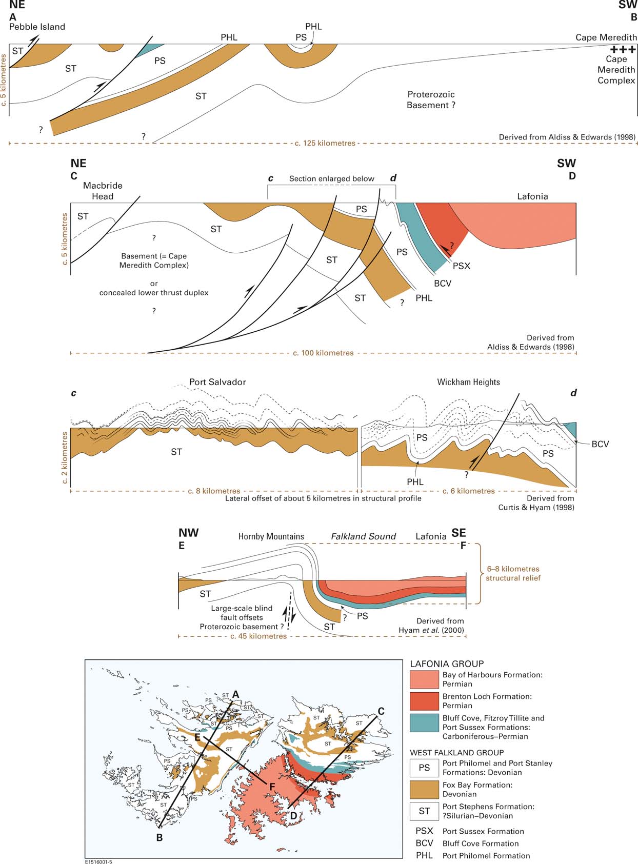
Figure 8 Representative onshore cross-sections illustrating the overall style of geological structure in the Falkland Islands.
In the northern part of East Falkland, the limbs of the large first-order folds (with wavelengths of about 3–4 km) are corrugated by congruent minor folding (Fig. 9a, b) that becomes more intense southwards into the Wickham Heights, where it is commonly tight and locally isoclinal (Fig. 8; section C–D). The Port Stanley Formation strata are particularly affected, with the alternation of hard quartzite beds and fissile carbonaceous siltstone aiding minor fold development and, perhaps, concealing the true extent of structural displacement. A strong slaty cleavage is widely developed, mostly in the more argillaceous lithologies, and the assemblage of structures and fabric demonstrates a sense of vergence towards the south. Cleavage is most intensely developed in an E–W zone on the south side of the Wickham Heights and to the east of the Darwin isthmus. There, the West Falkland Group strata and the Lafonia Group beds up to the Port Sussex Formation are all affected (Fig. 9c), but southward into Lafonia (and west of Darwin) the intensity of deformation decreases, so that the majority of the Lafonia Group strata is relatively flat-lying and has no cleavage. The overall pattern is of a S-directed fold and thrust belt, culminating in a deformation front along the south side of the Wickham Heights, ahead of which is a foreland basin (Fig. 8, section C–D). Within the latter, the upper part of the Lafonia Group remained undeformed (at D1 stage) with the exception of broad, gentle undulations and a number of minor, low-angle compressional thrusts, mostly directed towards the north (Fig. 9d).
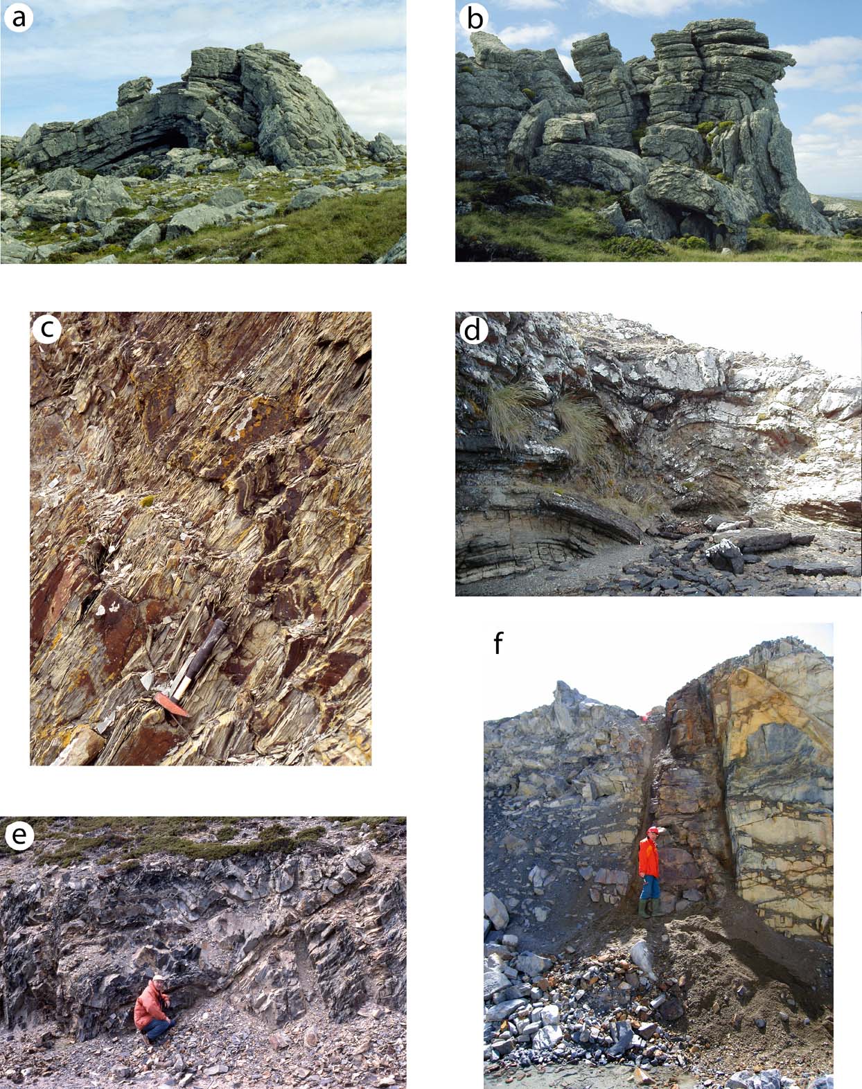
Figure 9 Examples of geological structure and dyke intrusion in East Falkland: (a) large asymmetrical anticline (viewed towards the west) in Port Stanley Formation quartzite at Wall Mountain, 15 km west of Stanley; (b) asymmetrical fold pair (viewed towards the east) in Port Stanley Formation quartzite at Wall Mountain, 15 km west of Stanley; (c) penetrative slaty cleavage (dip is towards the north) developed in thinly interbedded sandstone, mudstone and diamictite in the uppermost part of the Fitzroy Tillite Formation near Fitzroy; (d) localised fold and thrust development (N-verging) in sandstone of the Bay of Harbours Formation at Bodie Creek Bridge, 4 km SW of Goose Green; (e) fold and thrust development (S-verging) in mudstone of the Black Rock Member, Port Sussex Formation, at L'Antioja River, 27 km east of Darwin; (f) early Cretaceous dolerite dyke cutting steeply inclined beds of Port Stanley Formation quartzite at Pony's Pass Quarry, 7 km west of Stanley.
The geometry of the D1 thrust front in East Falkland is complicated by the apparent focusing of deformation within the highly fissile Black Rock Member of the Port Sussex Formation, at least locally (Fig. 9e). Given the overall regional structure, as discussed below, it would seem most probable that, in places, the Black Rock Member acted as a back-thrust décollement (Fig. 8, section C–D). With forward-breaking thrust-related deformation affecting the stratigraphically subjacent Fitzroy Tillite Formation immediately to the north, this would make the thrust front a structural triangle zone, albeit that the principal S-directed, forward-breaking thrusts are blind.
The second phase of deformation identified (D2) produced large-scale folding on broadly NE–SW axes, although there is much local variation around that trend. The folds are thought to be either draped over blind faults or to have formed within fault hanging walls, and occur across the western side of East Falkland and all of West Falkland. Most are relatively gentle structures, but one of more dramatic impact is the Hornby Mountains anticline that runs parallel to the east coast of West Falkland (Fig. 8, section E–F). Superimposition of the D2 Hornby Mountains fold on earlier D1 structures is at least partially responsible for large-scale, fold interference patterns, the style of which suggest that the underlying D2 fault movement was reverse and dextral. Alternatively, an additional, later episode can be envisaged (D3), that involved dextral reactivation of faults in a zone spanning Falkland Sound and the adjacent coasts. The combination of D2 and D3 faulting effects has produced a particularly marked series of NE–SW structural lineaments cutting across Lafonia, some prominent components of which act as structural control on the Darwin isthmus. In tectonic terms, as described by Aldiss & Edwards (Reference Aldiss and Edwards1999), this is a narrow graben formed within the hinge zone of an open, asymmetric D2 anticline, plunging to the southwest, and with its steeper limb dipping towards Falkland Sound, so as to mirror the downthrow effect of the Hornby Mountains anticline.
Aldiss & Edwards (Reference Aldiss and Edwards1999, pp 81–83) summarised the compelling evidence for a major fault zone coincident with the northwest side of Falkland Sound (discussed further in section 5.2.1). However, rather than place a major fault within Falkland Sound, Hyam et al. (Reference Hyam, Marshall, Bull and Sanderson2000) have modelled a major, blind reverse fault beneath the Hornby Mountains anticline, across which they calculated a structural relief (down to the southeast) of 6–8 km. Geophysical data allowed the basement fault to be traced offshore to the SW for about 8 km as a series of en échelon offsets. Onshore, there is local evidence for the reactivation of the fault with minor, normal downthrow to the west. A similar substantial displacement zone occurs farther to the west, within the southeast part of the Jason Islands, but runs approximately ENE–WSW. Considerable downthrow to the southeast is indicated by the contrasts in D1 fold style and cleavage development (described above) and metamorphism (see section 5.4).
Along the northern coastal margins of both East and West Falkland, there is evidence for the late-stage renewal of S- to SW-directed thrust movement involving brittle deformation, and so likely to have occurred at a relatively high structural level. The thrust sheet (D4) consists of Port Stephens Formation strata and has been emplaced above Fox Bay Formation beds, but the relationships are locally confused by subsequent reactivation of the D4 thrust and other, earlier structures in the north of the islands as normal faults with downthrow to the north. These late, extensional structures are likely to be associated with the development of the Mesozoic–Cenozoic offshore basins that surround the Falkland Islands (see section 8 below), and although they are grouped together as D5 structures, they may have formed over an extended time interval.
The late, dominantly NW–SE extensional faulting with downthrow to the NE (D5 of Aldiss & Edwards Reference Aldiss and Edwards1999) was thought to be more widespread and of greater significance by Lawrence et al. (Reference Lawrence, Johnson, Tubb, Marshallsea, Cameron, Bate and Clure1999). These investigators modelled the extensional faults as defining a series of arcuate half-grabens, the faulted (SW) side of which controlled the orientation of the northern coasts of both West and East Falkland, and which also extended south across Lafonia, where the faults influenced the positions and orientations of the major embayments: Brenton Loch, Choiseul Sound, Adventure Sound, Bay of Harbours. These putative Lafonian D5 faults were not identified during the geological survey work of Aldiss & Edwards (Reference Aldiss and Edwards1998), nor were they located during subsequent field work by the present author.
There is very little control on the deep structural character of the Falkland Islands; the deepest boreholes penetrated only a few hundred metres and there are no informative onshore, deep geophysical datasets. In East Falkland, a projection of the lithostratigraphical fold envelope (Fig. 8, section C–D) suggests a large-scale, S-verging monoclinal structure, most probably driven by blind thrusting at depth. A substantial sedimentary thickness clearly underlies Lafonia, but the situation farther north is less certain. There, either crystalline basement occurs at a relatively shallow depth, or the observable structure is essentially thin-skinned above a lower duplex of West Falkland Group strata. Similar uncertainties persist in interpretations of the more extensively studied Cape Fold Belt, with a thin-skinned model incorporating duplexing and out-of-sequence and piggy-back thrusting (e.g. Hälbich Reference Hälbich, de Wit and Ransome1992; Catuneanu et al. Reference Catuneanu, Hancox and Rubidge1998), contrasting with proposals of deeper, basement fault control and strike-slip partitioning (Tankard et al. Reference Tankard, Welsink, Aukes, Newton and Stettler2009).
In West Falkland, a Proterozoic crystalline basement crops out in the south of the island at Cape Meredith (Fig. 8, section A–B), with progressively younger divisions of the West Falkland Group appearing northwards in a relatively little-deformed succession. It is not clear whether the Cape Meredith complex basement outcrop is structurally in situ, or has been elevated by faulting within a broken foreland setting. There is evidence for S-directed thrusting in the north of West Falkland but, as in East Falkland, its deeper relationships remain unclear. Nevertheless, a shallower basement seems likely in West Falkland since, as described below, the Falkland Sound Fault and associated Hornby Mountains monocline create a substantial deep structural relief between it and East Falkland.
5.2.1. The Falkland Sound Fault
There is general agreement that the southeast coast of West Falkland is associated with a major fault or faults with downthrow to the east, one which is largely blind beneath the Hornby Mountains anticline (Fig. 8, section E–F). Overall, downthrow was sufficient to produce a structural relief of 6–8 km between West and East Falkland (Hyam et al. Reference Hyam, Marshall, Bull and Sanderson2000). The fault zone appears to have been a long-lived basement structure that was active during deposition, probably of the West Falkland Group and certainly of the Lafonia Group, with the progressive downthrow to the east allowing the accumulation of a much thicker succession in East Falkland than in West Falkland (e.g., Marshall Reference Marshall1994a; Aldiss & Edwards Reference Aldiss and Edwards1999). Thereafter, continued downthrow to the east was accompanied by dextral transpressive movement, but the amount of that movement remains uncertain. At one extreme, Thomas et al. (Reference Thomas, Jacobs, Weber and Ricci1997) argued for 300 km displacement; Hyam (Reference Hyam1998) preferred a reduced figure of ‘up to’ 60 km; whilst Curtis & Hyam (Reference Curtis and Hyam1998) and Aldiss & Edwards (Reference Aldiss and Edwards1999) thought the much smaller figures of, respectively, about 3.3 km and 5–10 km were adequate to explain the observed geological relationships. All of these authors regarded the principal dextral movements on the Hornby Mountains and/or Falkland Sound faults as being related to the D2 and D3 deformation events. Lawrence et al. (Reference Lawrence, Johnson, Tubb, Marshallsea, Cameron, Bate and Clure1999) noted that in the offshore area, their NW–SE extensional half grabens were apparently offset along a rift transfer zone that extended the line of Falkland Sound towards the NE. Accordingly, they proposed that at least some of the lateral movement along the Falkland Sound fault system could have been a relatively late process, in effect part of the D5 deformation of Aldiss & Edwards (Reference Aldiss and Edwards1999). Evidence for localised sinistral transpresssion in East Falkland (e.g., as described by Stone (Reference Stone2014) at Ordnance Point, near Stanley) was thought by Hodgkinson (Reference Hodgkinson2002) to be a conjugate effect to the dextral movement on the Falkland Sound Fault.
5.3. The timing of deformation
Strata up to Early Permian in age are affected by the D1 deformation, and many authors, over many years, have commented on the correspondence in style and timing of this deformation phase in the Falkland Islands with the broadly Late Permian to Early Triassic development of the Cape Fold Belt in South Africa. The transpressive structures of D2/D3 have been related to the break-up of Gondwana and the beginnings of independent movement of a Falklands microplate. Hodgkinson (Reference Hodgkinson2002) reported an Ar/Ar age of 278±8 Ma (mid-Permian) from metamorphic white micas in a fault zone on the east coast of East Falkland that he designated a D1 structure, but for which a D3 association (or at least reactivation) was preferred by Aldiss & Edwards (Reference Aldiss and Edwards1999). The initial break-up of Gondwana was associated with the intrusion of swarms of Early Jurassic dykes (see section 6, below) and one of these, the Pebble Island dyke (Fig. 10) appears to cut the D4 thrust front in the north of West Falkland. Overall, therefore, the D1 to D4 deformation episodes described from the Falkland Islands can all be regarded as broadly Permo-Triassic in age, and may represent phases within a structural continuum. The Cape Fold Belt has been described as a polyphase thrust assemblage generated sequentially between about 277 Ma and 229 Ma (e.g., Hälbich Reference Hälbich, de Wit and Ransome1992). The D5 extensional faulting seen in the north of the islands is related to the offshore development of the North Falkland Basin as the South Atlantic Ocean opened (see section 8, below) and may therefore have formed at any time from the Late Jurassic onwards. Extrapolating from their offshore interpretation, Lawrence et al. (Reference Lawrence, Johnson, Tubb, Marshallsea, Cameron, Bate and Clure1999) dated structures that would be associated with D5 in northern East Falkland (and also late movement on the Falkland Sound Fault) as Early Palaeogene. Late extensional fault reactivation in the Cape Fold Belt is usually considered to be a Cretaceous phenomenon (e.g., Hälbich Reference Hälbich, de Wit and Ransome1992), although by that time any direct correlation with events in the Falkland Islands would have become tenuous.

Figure 10 Linear aeromagnetic anomalies interpreted as arising from dolerite dykes, showing the location of the analysed and dated outcrops. Note that the aeromagnetic survey covered only the two main islands and extended neither to the western promontories of West Falkland, nor to the smaller offshore islands. The survey comprised N–S flight lines at a typical spacing of 500 m, with E–W tie lines at a spacing of 5 km; the flying height was 120 m above ground surface. Extent of the Cape Orford dyke swarm, after Aldiss & Edwards (Reference Aldiss and Edwards1999, fig. 3.1).
5.4. Metamorphism
With the exception of those forming the Proterozoic Cape Meredith Complex, all of the Falkland Islands' rocks are at a low metamorphic grade. Nevertheless, there are still significant differences between East and West Falkland. Aldiss & Edwards (Reference Aldiss and Edwards1999, fig. 4.11) plotted variations in the clay mineral maturity, based on illite crystallinity, to show that almost all of the West Falkland succession, together with that forming the western and northern fringes of East Falkland, was within the Late Diagenetic Zone. Higher grades were recorded to the west and east. To the west, the outer Jason Islands lie in the Epizone; to the east, in the central part of East Falkland, grade rose to the High Anchizone, with the highest grades coincident with the maximum development of cleavage within the deformation front to the south of the Wickham Heights and east of the Darwin isthmus. Most of the Lafonia Group is in the Low Anchizone, with even the youngest strata in the south of the Lafonia Group outcrop in East Falkland at a higher metamorphic grade than the oldest strata of the West Falkland Group outcrop in the south of West Falkland. Neither of these areas is much deformed and so the difference may be related to sedimentary burial, requiring a far thicker succession to have accumulated over East Falkland than West Falkland, so reinforcing the syn-sedimentary importance of a Falkland Sound fault zone, as discussed above.
A pattern of shallower sedimentary burial in West Falkland than in East Falkland was also deduced by Marshall (Reference Maisey, Borghi and Carvalho1994a) and Hyam et al. (Reference Hyam, Marshall, Bull and Sanderson2000) from vitrinite reflectance measurements. Marshall also described, from the northern part of West Falkland, a general northwards increase in vitrinite reflectivity from older into younger rocks, in the opposite sense to what would be expected from sedimentary burial. A corresponding northwards increase in reflectivity, across the southern part of East Falkland, was related to distance from the deformation front of the main fold and thrust belt, and a similar explanation was invoked by Marshall (Reference Marshall1994a) for West Falkland, where the deformation front lies farther to the north.
Burial, uplift and cooling histories were addressed by two studies integrating apatite fission track measurements and vitrinite reflectance: Lawrence et al. (Reference Lawrence, Johnson, Tubb, Marshallsea, Cameron, Bate and Clure1999) and Thomson et al. (Reference Thomson, Hegarty, Marshallsea and Green2002). Both studies identified three discrete episodes of heating and cooling that had affected the Falkland Islands succession, albeit with some ambiguity. Their results, which were broadly compatible, were consistent with an initial cooling phase in the Late Permian or Early Triassic that was initially restricted to West Falkland. This was caused by uplift and erosion there, relative to East Falkland, coincident with the D2 deformation that initiated the Hornby Mountains anticline. Subsequent Early Jurassic cooling that affected both East and West Falkland was related by Thomson et al. (Reference Thomson, Hegarty, Marshallsea and Green2002) to the thermal uplift preceding dyke intrusion (see section 6, below); Lawrence et al. (Reference Lawrence, Johnson, Tubb, Marshallsea, Cameron, Bate and Clure1999) invoked the end of active rifting and the mid-Jurassic cessation of magmatism. Thomson et al. (Reference Thomson, Hegarty, Marshallsea and Green2002) then identified renewed heating during the later part of the Mesozoic which they ascribed as most probably the result of subsidence and burial during initiation of the offshore sedimentary basins, with the possibility that the successions now seen therein might have originally encroached onto the present onshore region. The subsequently identified Early Cretaceous magmatism (Stone et al. Reference Stone, Richards, Kimbell, Esser and Reeves2008; see section 6, below) might also have played a part. Late Cretaceous and/or Early Palaeogene cooling followed regional uplift, associated with large-scale tectonic adjustments along the southern margin of the Falkland Plateau, at the North Scotia Ridge Transform Fault (Fig. 1).
6. Mesozoic dyke swarms
6.1. Discovery and distribution
Mafic dykes are a common feature in West Falkland, but are comparatively rare in East Falkland. The first definitive observations were made, most probably in 1844, by Captain (later Admiral Sir) Bartholomew Sulivan during a survey voyage by HMS Philomel (Stone & Rushton Reference Stone and Rushton2013). Sulivan had previously served on HMS Beagle, had become firm friends with Darwin during that voyage, and wrote to Darwin from HMS Philomel reporting his new geological discoveries in West Falkland. The dyke descriptions are contained in a letter dated 13th January to 12th February 1845 (Darwin Correspondence Number 730, Burkhardt & Smith Reference Burkhardt and Smith1987). Sulivan wrote of “[n]umerous dykes running perpendicular in a North and South direction” and commented that “there are hundreds of these dykes running miles in length … and some are twenty feet wide, and all sizes from that down to two inches”. Darwin received Sulivan's letter in time to add a footnote – “Captain Sulivan observed on the western island numerous basaltic dykes” – to his 1846 paper “On the geology of the Falkland Islands”, which had been presented at a meeting of the Geological Society of London on March 25th of that year.
With only Darwin's rather vague, 1846 footnote as a published guide, the full extent of the West Falkland dyke swarm remained unappreciated and did not become apparent until more detailed geological investigations in the early twentieth century by Andersson (Reference Andersson1907), Halle (Reference Halle1911) and Baker (Reference Baker1924), the last of whom reported dyke trends as varying from NNE–SSW around to WNW–ESE and suggested that they all shared a radial disposition emanating from a point somewhere to the east of Cape Meredith, the southern extremity of West Falkland (Fig. 2). This proposal was negated by the photo-interpretation of Greenway (Reference Greenway1972), who identified up to 400 individual dykes on West Falkland and separated them into two distinct but intersecting swarms: NNE–SSW dykes occurred mostly in the north and centre of the island, whereas WNW–ESE dykes were confined to the south. A more variable pattern in the SW of West Falkland, around Cape Orford and on Weddell Island, was described by Greenway as an area of overlap. Aldiss & Edwards (Reference Aldiss and Edwards1999) mapped and described the West Falkland dykes in terms of six swarms defined on the basis of petrographic detail, orientation, distribution and field characteristics. They referred the NNE–SSW dykes to a Sulivan Swarm, divided the WNW–ESE dykes into a northern Fox Bay Swarm and a southern South Harbour Swarm, and formalised the Cape Orford Swarm as a more varied assemblage than had been previously appreciated. Two other swarms were of relatively restricted extent on outlying islands to the west of West Falkland. Nevertheless, the dominant, regional pattern of dyke orientation established by Aldiss and Edwards was not fundamentally at odds with the previously established trends. Dyke thickness is mostly commonly in the range of a few metres to a few tens of metres, but some are several hundred metres across, whilst many are only a few centimetres wide.
Except at the coast, many of the dykes are only very poorly exposed and, until the end of the 20th Century, very few had been recorded from East Falkland where, in addition, potential aerial photograph lineaments were obscured by the generally thick cover of superficial material. Those few dykes that were seen appeared to broadly follow the NNE–SSW trend. Thereafter, a commercial aeromagnetic survey flown in 2004 detected more dykes (on the basis that dolerite dykes were the cause of the sharp, linear anomalies seen) and suggested an additional sub-division of the swarms (Stone et al. Reference Stone, Richards, Kimbell, Esser and Reeves2008; Stone Reference Stone2013). Across West Falkland, the aeromagnetic survey allowed the NNE–SSW dykes to be resolved into two discrete and intersecting swarms: dykes forming one of the swarms run N–S, whilst the dykes defining the other swarm trend broadly NE–SW (Fig. 10). The latter is widespread in West Falkland, with a few outlying members present in East Falkland. The N–S swarm comprised about 40 dykes spaced equally (albeit exposed only very rarely) across both East and West Falkland. In East Falkland, the dykes of the N–S swarm swing into a more NNW–SSE orientation as they are traced northwards on the basis of their linear anomalies.
The distribution of linear aeromagnetic anomalies suggest a much greater dyke density than had been previously recorded, but there are nevertheless a few well-known dykes running broadly N–S in the northern part of West Falkland that do not appear to lie on linear anomalies (cf. Aldiss & Edwards Reference Aldiss and Edwards1998). The explanation for this apparent mismatch probably lies in the distribution and orientation of the airborne survey's flight lines which, across much of West Falkland, ran N–S and had a spacing of 500 m. However, in a 10 km-wide strip in the NE of that island, technical problems resulted in a line spacing of 1 km. The ‘missing’ anomalies mostly lie within this zone and their absence from the airborne results is probably the result of their source dykes being parallel to the widely spaced, N–S flight lines. Even with the more closely spaced flight lines, their parallelism with the N–S dykes creates an issue of poor anomaly resolution that requires careful interpretation.
Perhaps uniquely for the Falkland Islands, the small South Fur Island (between West Point Island and the Jason Islands, Fig. 2) appears to be formed from a dolerite sill intruded into felsic tuff. Aldiss & Edwards (Reference Aldiss and Edwards1999, pp 58–61) associate the sill with the Early Jurassic dykes and from this relationship, coupled with the distribution of distinctive beach pebbles on the West Falkland coast, speculate that a bimodal, Jurassic volcanic suite may crop out on the sea floor in the northwest part of the archipelago.
6.2. The ages of the dyke swarms
A Jurassic age for West Falkland dykes was first established by radiometric dating of dykes from the vicinity of Cape Meredith. These gave K–Ar dates of 192±10 Ma (Cingolani & Varela Reference Cingolani and Varela1976) and 176±7 Ma and 162±6 Ma (Thistlewood et al. Reference Thistlewood, Leat, Millar, Storey and Vaughan1997) for the NE–SW trending swarm. More precise Ar–Ar dates were reported by Mussett & Taylor (Reference Mussett and Taylor1994): a dyke from the Cape Orford swarm gave 190±4 Ma; an E–W dyke gave 188±2 Ma; and a NE–SW dyke gave a maximum age of 193±4 Ma (Fig. 3). These three Ar–Ar dates were regarded as indistinguishable within error, and were taken to show intrusion of all of the West Falkland dykes at about 190 Ma during the Early Jurassic. An Ar–Ar date of 178.6±4.9 Ma was obtained by Stone et al. (Reference Stone, Richards, Kimbell, Esser and Reeves2008) from the NE–SW dyke at Port Sussex in East Falkland (Fig. 10). This age is compatible with the Ar–Ar maximum age of c. 193 Ma reported by Mussett & Taylor (Reference Mussett and Taylor1994) from a NE–SW dyke in West Falkland, but is more closely aligned with the K–Ar date of about 177 Ma reported by Thistlewood et al. (Reference Thistlewood, Leat, Millar, Storey and Vaughan1997) from Cape Meredith.
The N–S dyke swarm identified from the aeromagnetic survey proved to be of a younger, Early Cretaceous age. The first result, an Ar–Ar date of 121.3±1.2 Ma (Aptian) was reported by Stone et al. (Reference Stone, Richards, Kimbell, Esser and Reeves2008) from the east side of East Falkland (Fig. 10, Pony's Pass Quarry (Fig. 9f)); a second series of Ar–Ar dates reported from two other dykes on the west side of East Falkland (Fig. 10, Teal Creek and Peat Banks) by Richards et al. (Reference Richards, Stone, Kimbell, McIntosh and Phillips2013) ranged between 131±4 Ma and 138±4 Ma (Valanginian to Hauterivian). The difference might raise questions about the homogeneity of the Cretaceous dyke swarm, and of relevance in that respect is the variation in palaeomagnetic polarity shown by the aeromagnetic anomalies. Across the whole N–S swarm, the eastern dykes show reversed magnetic polarity, but the majority of those further to the west have normal polarity. Of the two dated, ca.131–138 Ma dykes, the polarity of one is reversed, whilst that of the other is normal. The overlapping ages of these dykes suggest that magmatism lasted long enough to span a magnetic reversal, of which there were several at around that time. The apparently younger N–S dyke has reversed polarity, although the 121 Ma age places it within the early part of the normal polarity Cretaceous super-chron, the so-called Cretaceous quiet zone. This contradiction raises some doubt as to the date's validity.
6.3. Compositions of the different dyke swarms
All of the Cretaceous dykes are petrographically very similar plagioclase–clinopyroxene–orthopyroxene dolerites, with a characteristic glassy groundmass. They are distinct from the Jurassic dykes, which mostly fall into two categories: those forming the E–W swarm are plagioclase–clinopyroxene–olivine dolerites; whereas the NE–SW dykes are plagioclase–clinopyroxene–orthopyroxene dolerites, lacking the glassy matrix characteristic of the Cretaceous dykes; the Cretaceous dykes are also markedly Fe-rich relative to all of the Jurassic examples (Mitchell et al. Reference Mitchell, Ellam and Cox1999; Stone et al. Reference Stone, Richards, Kimbell, Esser and Reeves2008). The geochemical similarities and contrasts are illustrated in Figure 11 as a series of variation diagrams for selected major and trace elements plotted against MgO. Data for the dated East Falkland dykes (Stone Reference Stone2013) are superimposed on fields derived for the West Falkland, Jurassic dykes by Mitchell et al. (Reference Mitchell, Ellam and Cox1999); also included are results from the NE–SW-trending and low-Fe (and so presumed Jurassic) Lively Island dyke (Figs 2, 10); an unusual occurrence from which the similarity of results demonstrates the compatibility of the two datasets. Two dykes identified by Mitchell et al. (Reference Mitchell, Ellam and Cox1999) from the south of West Falkland as having an unusual, ‘evolved’ character, but still presumed by them to be Early Jurassic, have some compositional similarities with the subsequently-identified Early Cretaceous swarm, but the given localities do not appear to be associated with appropriately N–S aeromagnetic anomalies.
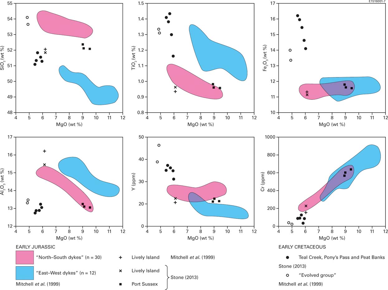
Figure 11 Variation diagrams for selected major oxides and trace elements (plotted against MgO) that illustrate the contrasting compositions of the different dyke swarms.
The results from Mitchell et al. (Reference Mitchell, Ellam and Cox1999) clearly demonstrate that there are systematic differences between the Jurassic NW–SE and E–W dyke swarms of West Falkland (Fig. 11). The East Falkland Cretaceous dykes form a distinct cluster in a range of element ratios, with no overlap into the Jurassic fields. Despite the apparent variation in their ages, there are no significant compositional differences between the N–S dykes from the east and west sides of East Falkland.
The Early Jurassic Cape Orford dyke swarm was described by Mitchell et al. (Reference Mitchell, Ellam and Cox1999) as comprising highly altered, broadly andesitic rock types; Aldiss & Edwards (Reference Aldiss and Edwards1999) reported a greater variety, ranging from feldsparphyric dolerite to probable rhyolite. Aldiss & Edwards also suggested that two additional, localised dyke swarms, both of doleritic lithologies, were present on outlying islands to the west of West Falkland: New Island and Saunders Islands. Information on these is sparse and they lie beyond the western margin of the aeromagnetic survey. It seems very likely that the dyke swarms in West Falkland are more complex than currently appreciated and would be well worth further investigation.
7. The Falkland Islands in Gondwana
7.1. The historical perspective
Following the work of Halle (Reference Halle1911) and Baker (Reference Baker1924), the close association of Falkland Islands geology with that of South Africa was generally appreciated. In both areas, a similarly-aged metamorphic basement was overlain by a Palaeozoic sedimentary succession containing a ‘Malvinokaffric’ fossil assemblage. The deformed strata of the West Falkland Group corresponded to the Cape Fold Belt, the less-deformed Lafonia Group to the Karoo Basin, whilst both areas were intruded by swarms of mafic dykes. By way of explanation, Baker had invoked the continental drift ideas championed by Wegener in a series of publications from 1912 onwards, but which would have been topically accessible to Baker when an English translation of the third edition of Wegener's book Die Ehtstehung der Kontinente und Ozeane (Wegener Reference Wegener1922) was published in 1924. Baker did not propose any palaeogeographical reorganisation to accommodate the regional correlations, which was left to Du Toit (Reference Du Toit1927), who went on to become continental drift's most influential advocate with publication of Our Wandering Continents (Du Toit Reference Du Toit1937).
It was not just the Falkland Islands that were geologically similar to South Africa. Keidel (Reference Keidel1916) had noted the correlation of the South African geology with that of the Ventania System (sensu Alessandretti et al. Reference Alessandretti, Philipp, Chemale, Brückmann, Zvirtes, Matté and Ramos2013) of Argentina. When Du Toit (Reference Du Toit1927, Reference Du Toit1937) reconstructed a pre-Atlantic Gondwana, these two regions were aligned into a single fold belt and basin. But that left the Falkland Islands isolated a long way to the south, and Du Toit's revolutionary solution was to move them northwards until they sat between the Sierra de la Ventana (the fold belt wherein forms part of the Ventania System) and the Western Cape (Fig. 12a). This solution did not find much support. The rejection of continental drift by the geological mainstream has been well documented (e.g., Newman Reference Newman1995; Oreskes Reference Oreskes1999) and the majority view at the end of the 1920s was illustrated by Gregory (Reference Gregory1929) in his Presidential Address to the Geological Society of London. Therein, Gregory portrayed Gondwana as encompassing Africa, South America and a huge landmass between them that had subsided beneath the waters of the South Atlantic Ocean; the Falkland Islands were seen as a marginal vestige of that landmass.
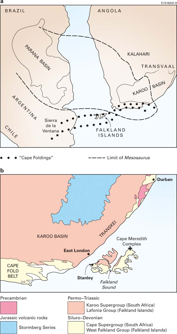
Figure 12 Two early solutions to the problem of the Falkland Islands' apparently misplaced geology: (a) the early attempt by Du Toit (Reference Du Toit1927, Reference Du Toit1937) to align the main Falkland Islands structures with those of Ventania (Argentina) and Cape Province (South Africa); (b) the radical solution proposed by Adie (Reference Adie1952a) in which the islands are rotated anticlockwise through 180° (30° for opening of the South Atlantic and 150° for pre-Atlantic rotation) to an original position adjacent to the SE coast of South Africa, where they form the ‘missing’ SE corner of the Karoo Basin. Du Toit's Gondwana reconstruction shows the ‘Limit of Mesosaurus’, the short-legged terrestrial reptile whose Permian palaeogeographical distribution influenced early views of Gondwana. My colleague D. Aldiss recalls (pers. comm. August 2015) attending a lecture by Adie in the 1970s, during which he predicted the eventual discovery of Mesosaurus in the Falkland Islands. So far this has not happened.
Despite the generally dismissive view of continental drift held by the geological mainstream throughout the first half of the 20th Century, it did have its champions, particularly amongst geologists with southern hemisphere experience. Notable advocates were Arthur Holmes (UK), Lester King (South Africa) and S. Warren Carey (Australia), whilst many of those geologists active in the South Atlantic region also viewed the process as an attractive explanation for the regional geology (Stone Reference Stone2015). For the Falkland Islands, the most radical proposal came from Adie (Reference Adie1952a), who aligned structural and sedimentological trends to support the rotation of a Falkland Islands continental block through about 180° from an original position adjacent to the east coast of South Africa (Fig. 12b). Adie's solution was largely ignored, particularly when early plate tectonic reconstructions appeared to successfully model the opening of the Atlantic Ocean, with the Falkland Islands and Plateau left as a continental promontory from southern South America (e.g., Rabinowitz & LaBrecque Reference Rabinowitz and LaBrecque1979; Martin et al. Reference Martin, Hartnady and Gooodland1981). This changed when the apparently independent movement of the Falkland Islands was rediscovered in terms of microplate rotation, supported by palaeomagnetic data (Mitchell et al. Reference Mitchell, Taylor, Cox and Shaw1986).
7.2. The South African connection
The well-established correlation between Falkland Islands and South African stratigraphy (Halle Reference Halle1911; Baker Reference Baker1924; Adie Reference Adie1952a, Reference Adie and Teichertb) is summarised in Table 1. The Proterozoic rocks of the Cape Meredith Complex have counterparts in the Namaqualand–Natal Metamorphic Complex (NNMC), although there are some differences in age (reviewed by Aldiss & Edwards Reference Aldiss and Edwards1999), and similarities with the Deseado Massif of Patagonia have also been noted (Borrello Reference Borrello1963; Ramos Reference Ramos2008). The metamorphic basement of the Maurice Ewing Bank, proved during DSDP leg 36 (Tarney Reference Tarney1977), could also be related to the NNMC and so enable all of the Falkland Plateau, prior to its extension, to be positioned in the Natal embayment, between South Africa and East Antarctica (Fig. 4).
Table 1 The broad lithostratigraphical correlation between the Falkland Islands (West Falkland and Lafonia Groups) and South Africa (Cape and Karoo Supergroups)
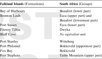
Correlations of the sedimentary successions of the Falkland Islands and South Africa are particularly compelling. Detailed comparisons have been drawn between the Port Stephens Formation and the Nardouw Subgroup, the upper part of the Table Mountain Group (Hunter & Lomas Reference Hunter and Lomas2003) and between the Lafonia Group and the Dwyka, Ecca and Beaufort groups of the Karoo Basin (Trewin et al. Reference Trewin, Macdonald and Thomas2002). The faunal and lithofacies similarities between the Fox Bay Formation and the Bokkeveld Group were apparent to the earliest workers (e.g., Sharpe & Salter Reference Sharpe and Salter1856) and were influential in shaping Adie's (Reference Adie1952a) model – as a South African, Adie had arrived in the Falklands well primed in the relevant geology. Another well-established (Halle Reference Halle1911) pair of correlative units is the glacigenic beds deposited during the Permo-Carboniferous glaciation of southern Gondwana: the Fitzroy Tillite Formation and the diamictites of the Dwyka Group, both deposited during the Early Permian. The general lithofacies similarity extends to the erratic content, including such details as the detrital zircon population (Craddock & Thomas Reference Craddock and Thomas2011) and the archaeocyathid assemblage in exotic clasts of Early Cambrian limestone (Stone & Thomson Reference Stone, Thomson, Vaughan, Leat and Pankhurst2005; Stone et al. Reference Stone, Thomson and Rushton2012). All of the archaeocyathan limestone was thought to have originated in the Transantarctic Mountains, but recent discoveries in Argentina (González et al. Reference González, Tortello, Damborenea, Naipauer, Sato and Varela2013) have added a new dimension to the regional picture that is not yet fully appreciated.
In South Africa, the Cape Fold Belt and Karoo Basin are generally regarded as having developed as a retroarc fold and thrust belt verging northwards, with a preceding foreland basin (e.g., Catuneanu et al. Reference Catuneanu, Hancox and Rubidge1998 and references therein). An alternative interpretation (Tankard et al. Reference Tankard, Welsink, Aukes, Newton and Stettler2009, Reference Tankard, Welsink, Aukes, Newton, Stettler, Roberts and Bally2012) points to perceived weaknesses in that model and regards the Cape Fold Belt as a sinistral strike-slip orogen driven by the reactivation of deep basement structures, with only the later part of the Karoo succession deposited in a foreland basin environment. Whichever version is preferred for southern Africa, to the west, in Argentina, regionally correlative and structurally N-verging geotectonic features now form the Ventania System: the Sierra de la Ventana fold and thrust belt and the Claromecó foreland basin (e.g., Milani & de Wit Reference Milani, de Wit, Pankhurst, Trouw, Brito Neves and De Wit2008; Alessandretti et al. Reference Alessandretti, Philipp, Chemale, Brückmann, Zvirtes, Matté and Ramos2013). When rotated into a position off the east coast of South Africa – the Adie (Reference Adie1952a) model (Fig. 12b) – the Falklands fold belt and Lafonia basin (S-verging in their current position) become, respectively, the eastern extension of the N-verging Cape Fold Belt and the otherwise missing, SE corner of the Karoo Basin. More detailed similarities in the structural history of the Falkland Islands and South Africa were stressed by Curtis & Hyam (Reference Curtis and Hyam1998), but it was new information from the Falkland Islands dyke swarms that had first rejuvenated Adie's rotational model.
There is an undisputed regional association of the Early Jurassic dykes from the Falkland Islands, dated ca.178–184 Ma, with the Karoo–Ferrar magmatism in South Africa and Antarctica: Karoo magmatism peaked at ca.183 Ma, with the peak of Ferrar magmatism a little later at about 180 Ma (e.g., Encarnación et al. Reference Encarnación, Fleming, Elliot and Eales1996; Duncan et al. Reference Duncan, Hooper, Rehacek, Marsh and Duncan1997; Riley & Knight Reference Riley and Knight2001). Mitchell et al. (Reference Mitchell, Ellam and Cox1999) showed that the Falklands Jurassic dykes marked an overlap between the Karoo and Ferrar provinces, with the E–W Falkland swarm made up of Karoo-type dolerite and the NE–SW Falkland dykes showing more affinity to Ferrar-type dolerite (Fig. 4); the latter association had also been noted by Thistlewood et al. (Reference Thistlewood, Leat, Millar, Storey and Vaughan1997). A popular hypothesis for the generation of the Early Jurassic, Karoo magmatism that spanned the South African and Antarctic (Dronning Maud Land) segments of Gondwana, associated it with a mantle plume responsible for initiating the break-up of that supercontinent (e.g., Storey et al. Reference Storey, Curtis, Ferris, Hunter and Livermore1999); whilst the regional picture may well be more complicated, the involvement of a focused thermal anomaly is highly likely (Storey et al. Reference Storey, Vaughan and Riley2013). In contrast, the origin of the Ferrar igneous province remains unresolved. Its linear outcrop parallel to the active, ‘Pacific’ margin of Gondwana (Fig. 4) invites an association with subduction, but the distance from the active margin is unusually large and other models have been proposed, as reviewed by Storey et al. (Reference Storey, Vaughan and Riley2013).
The Early Cretaceous dykes from the Falkland Islands, with ages in the range 135–121 Ma, are more likely to have arisen from magmatism generated during the subsequent, early stages of Atlantic Ocean rifting. Richards et al. (Reference Baker2013 and references therein) drew comparisons with the ca.134–129 Ma Paraná–Etendeka flood basalts and associated dykes, which are now preserved much further north on opposite sides of the South Atlantic (Brazil and Angola/Namibia), and to the ca.131 Ma dyke swarm that occurs in the Cape Peninsula–False Bay area of SW South Africa.
Independent rotation of a Falklands microplate has implications for its relationship with the rest of the Falkland Plateau and, in particular, with the Maurice Ewing Bank, which would also need to be regarded as an independent microplate. Originally in close proximity (Fig. 4), considerable extension between them would have been needed to create the present-day dimensions of the Falkland Plateau. Marshall (1994a, b) suggested Early Jurassic extension preceding rotation of the Falklands microplate; Macdonald et al. (Reference Macdonald, Gomez-Perez, Franzese, Spalletti, Lawver, Gahagan, Dalziel, Thomas, Trewin, Hole and Paton2003) saw the extended area as a failed rift that developed post-rotation. The latter explanation could also be applied to a fixed, non-rotational interpretation of the region to satisfy some of the space problem inherent in plate reconstructions that utilise the current dimensions of the plateau. In either case, extension might well correlate with the intrusion of the Early Cretaceous dyke swarm seen onshore in the Falkland Islands.
7.3. Palaeomagnetism
An overlap between Karoo-type and Ferrar-type magmatism would be compatible with the position of the rotated Falkland Islands in Gondwana, when the islands would lie between South Africa and East Antarctica. But the more compelling evidence for rotation presented by Mitchell et al. (Reference Mitchell, Taylor, Cox and Shaw1986), and then in more detail by Taylor & Shaw (Reference Taylor, Shaw and Hillhouse1989), was derived from the palaeomagnetic record in the Falkland Islands' Early Jurassic dykes. Although described rather dismissively as “meagre” by de Wit (Reference de Wit, de Wit and Ransome1992), this data supported a substantial clockwise rotation of the Falklands microplate by about 100°, with systematic differences in the characteristic remanence directions between the three principal Early Jurassic swarms. The differences were taken to show intrusion during rotation, but it was subsequently established that there was little difference in the ages of the dykes concerned (Mussett & Taylor Reference Mussett and Taylor1994).
In an attempt to clarify the situation, Thistlewood & Randall (Reference Thistlewood and Randall1998) reported the palaeomagnetic properties of the Falklands sedimentary succession. The West Falkland Group gave no useable results, but some samples from the Port Sussex Formation (Lafonia Group), despite modern overprinting, preserved a remanent magnetisation requiring rotation of approximately 100° into the current orientation. Nevertheless, when, in a subsequent study, Hodgkinson (Reference Hodgkinson2002) was unable to repeat the palaeomagnetic results, he noted that the NE–SW dykes, and possibly others, were intruded into a transpressive regime and that shearing had affected the minerals on which the palaeomagnetic measurements relied. Hodgkinson, therefore, questioned their reliability, but additional evidence in support of rotation was then derived from the aeromagnetic survey results by Stone et al. (Reference Stone, Kimbell and Richards2009). They showed that the differing asymmetries of the linear magnetic anomalies associated, respectively, with the NE–SW Early Jurassic dykes and the N–S Early Cretaceous dykes were most compatible with a 120° rotation of the host block between the intrusions of the two swarms.
8. The offshore sedimentary basins
Seismic refraction profiles had been shot across the Falklands area in the late 1950s as part of an academic research project based at the Lamont-Doherty Geological Observatory (now Earth Observatory) of Columbia University, City of New York. These were followed by more seismic experiments during the early 1970s, culminating in 1974 in the drilling of three boreholes on the Maurice Ewing Bank, some 600 km to the east of the Falkland Islands (Fig. 1), as part of the international Deep Sea Drilling Project, Leg 36. Amongst the discoveries made, the boreholes proved the existence of a potential oil source rock, and so encouraged more commercial interest. During the 1977–78 austral summer, two speculative, regional seismic surveys were shot around the Falkland Islands, but the data acquired remained proprietary and were not made publically available.
Following the invasion and temporary occupation of the Falkland Islands by an Argentine military force in 1982, it was not until the early 1990s, and with the British Geological Survey having been appointed by the Falkland Islands Government to help manage and promote hydrocarbon activity, that renewed interest in the offshore potential led to the acquisition of more speculative seismic data to both the north and south of the archipelago. In 1996, the first Production Licenses were awarded for acreage to the north, in the North Falkland Basin, and initiated the more focused exploration programmes that continue today. The location of the sedimentary basins under investigation is shown in Figure 1; their geology was reviewed by Richards et al. (Reference Richards, Gatliff, Quinn, Williamson, Fannin, Storey, King and Livermore1996). Since then they have been the subject of extensive seismic surveys and a number of exploration wells have been drilled, mostly in the North Falkland Basin. With only a few exceptions, the data collected are held on a confidential basis by the companies concerned and are commercially sensitive. Nevertheless, the general configuration of the sedimentary basin network surrounding the Falkland Islands has been confirmed. They all contain a Jurassic and younger sedimentary succession that lies either on strata equivalent to the onshore West Falkland and Lafonia groups, or on possible Jurassic volcanic rocks. Aldiss & Edwards (Reference Aldiss and Edwards1999, p. 60) argued for the presence of a Jurassic, bimodal volcanic suite at outcrop on the sea floor in the northwest coastal zone of the archipelago, but this has not yet been confirmed.
This review attempts to provide a broad, regional summary of the basins' structure and stratigraphy. It does not consider detail of the specialist petroleum geology.
8.1. North Falkland Basin
To the north of the Falklands archipelago, the North Falkland Basin is a classic example of a failed-rift basin (Fig. 13a) with two main structural components (Richards & Fannin Reference Richards and Fannin1997; Richards & Hillier Reference Richards and Hillier2000a, Reference Richards and Hillierb; Lohr & Underhill Reference Lohr, Underhill, Williams, Newbold and Underhill2015). An elongate area of subsidence controlled by extensional faults running approximately N–S (the North Falkland Graben) is 20–40 km wide and about 250 km long, with the southern margin only some 35 km north of the islands. To the S and SW of the graben is another area of subsidence controlled partly by N–S extensional faults and partly by NW–SE extensional faults, thought to be influenced by the reactivation of structures that originated as compressional thrusts in the underlying Palaeozoic rocks. Reactivation of this sort has been described from the West Falkland Group at the onshore northern margins of East and West Falklands.

Figure 13 Representative cross-sections of two of the Mesozoic to Palaeogene sedimentary basins in the Falkland Islands offshore zone: (a) the northern part of the North Falkland Basin, developed from Richards & Fannin (Reference Richards and Fannin1997) and Richards & Hillier (Reference Richards and Hillier2000a, Reference Richards and Hillierb); (b) the South Falkland Basin, after Richards et al. (Reference Richards, Gatliff, Quinn, Williamson, Fannin, Storey, King and Livermore1996) and Bry et al. (Reference Bry, White, Singh, England and Trowell2004).
There have now been three drilling campaigns in the North Falkland Basin, the first in 1998 with six wells, the second in 2010–2011 with 16 wells, and the third in 2015 with five wells. Of these, at least six have made potentially commercial hydrocarbon discoveries, and a thematic set of papers devoted to the petroleum geology of the highly promising Sea Lion Field has been published recently in Petroleum Geoscience (Williams et al. Reference Williams, Newbold and Underhill2015). As a result of the drilling campaigns, and with the additional data generated by detailed seismic surveys, the regional structure and stratigraphy of the basin are becoming clearer. Subsidence probably began with E–W extension during the Jurassic and into the earliest Cretaceous, commensurate with the initial break-up of Gondwana. Then, through the Early Cretaceous, subsidence continued as thermally-driven basin sag. In some parts of the basin, subsidence gave way to localised and intermittent uplift during the Cretaceous, as a distant effect of the rise of the Andean Cordillera and the related initiation of uplift along the North Scotia Ridge farther to the south.
Lohr & Underhill (Reference Lohr, Underhill, Williams, Newbold and Underhill2015) stress the different structural histories of the North Falkland Graben, and the sub-basin on its SW flank, describing them as two separate but transecting rifts and proposing that they should be differentiated as the Northern and Southern Rift basins. The Southern Rift Basin was interpreted as the older of the two, initiated in the Late Jurassic and controlled by faults striking NW–SE. The Northern Rift Basin was initiated a little later by N–S faults, which are underlain at depth by structures related to the northern extension of the Southern Rift Basin. The southern extension of the Northern Rift Basin, originally superimposed on the southern rift, has been largely removed by erosion following uplift in the forebulge region, developed in association with plate margin tectonics farther south at the North Scotia Ridge transform fault. Within the same regional tectonic pattern, subsidence continues across the North Falkland Basin's northern rift.
The Jurassic and earliest Cretaceous sedimentation took place in fluvial plains, associated alluvial fans and ephemeral lakes. Thereafter, through much of the Early Cretaceous, a large and permanent lake system occupied the central part of the North Falkland Graben (Northern Rift Basin); analogies have been drawn with Lake Malawi in the present-day East African Rift (Richards & Hillier Reference Richards and Hillier2000a, Reference Richards and Hillierb). The North Falkland Graben lake most probably reached depths of over 500 m in places and had a stratified water column, with an oxygenated upper layer supporting some fish and algal life but a stagnant, anoxic bottom layer. From the north, the basin was filled by a large sandy delta; smaller deltas extended from other parts of the basin margins, but elsewhere these merged laterally with swampy alluvial plains (Richards et al. Reference Richards, Duncan, Phipps, Pickering, Grzywacz, Hoult and Merritt2006). The sedimentary deposits filling the basin, up to and possibly exceeding 10 km in thickness, are dominantly lacustrine and deltaic clay, mudstone and turbiditic sandstone in the lower part of the succession and fluvial sandstones in the upper part. Some of the mudstones are highly organic and are the source rocks for the basin's hydrocarbons. From the Late Cretaceous onwards, the succession becomes progressively more marine, with several sandstone intervals showing high-quality reservoir properties.
8.2. The southern basins
To the south of the Falkland Islands three basins are identified, although they are structurally linked along their southern margins by interaction with the major structural boundary between the Falklands microplate/plateau and the Scotia plate to the south. Despite this common feature, the structure of each basin has unique elements, and they all differ markedly from the ‘failed-rift’ structural configuration seen in the North Falkland Basin.
To the SE of the Falklands archipelago, the Falkland Plateau Basin is a passive margin-type basin on the SE flank of the Falkland Plateau; it is bordered to the south by the Burdwood Bank and to the east by the Maurice Ewing Bank (Fig. 1). The basin contains a succession of Late Jurassic to Cretaceous strata, up to about 15 km thick, which has so far been examined by only four commercial wells. At its eastern extremity, the basinal strata extend onto the Maurice Ewing Bank, where DSDP borehole 330 showed them to lie unconformably on Proterozoic crystalline rocks. Elsewhere in the basin, seismic evidence has been interpreted as showing that the Jurassic to Cretaceous sedimentary succession overlies rocks akin to those of the onshore West Falkland and Lafonia groups. Seismic basement was sampled in 2010 by a commercial well that terminated at 2476 m below sea level in aphyric, plagioclase–clinopyroxene–olivine dolerite of similar petrographic character to that forming the E–W, Early Jurassic dykes onshore (Richards et al. Reference Richards, Stone, Kimbell, McIntosh and Phillips2013). If this association is correct, it would make the ‘seismic basement’ dolerites part of the Early Jurassic and pre-Atlantic, Karoo–Ferrar magmatism. A somewhat different interpretation arises from the proposals by Marshall (Reference Marshall1994b) and Barker (Reference Barker1999) that the offshore, SE margin of the Falkland Islands block was a volcanic, rifted continental margin, and that oceanic crust was created between the Falklands and Maurice Ewing microplates during extension of the Falkland Plateau; a Late Jurassic or Early Cretaceous age might then seem more likely for the ‘seismic basement’ dolerites. The presence of a thick doleritic ‘basement’ beneath the Falkland Plateau Basin, generated either as oceanic crust or during Karoo–Ferrar ‘underplating’ and replacement of thin continental crust, received additional support from gravity modelling reported by Kimbell & Richards (Reference Kimbell and Richards2008) and from seismic refraction observations by Klemt & Jokat (Reference Klemt and Jokat2015). The high heat-flow regime that would have existed during basin extension and oceanic crust formation was thought by Marshall (Reference Marshall1994b) to have much reduced the hydrocarbon potential of the Falkland Plateau.
Richards et al. (Reference Richards, Gatliff, Quinn, Williamson, Fannin, Storey, King and Livermore1996) dated the relatively thick (up to about 3 km) succession of Jurassic to Early Cretaceous rocks in the Falkland Plateau Basin by extrapolation of the seismic profiles back to the DSDP boreholes on the Maurice Ewing Bank. The succession is interpreted as a marine series of deltaic or shelf margin fan systems prograding and thickening towards the SE, where they merge with possible slump masses and/or basin-floor turbidite deposits (Richards et al. Reference Richards, Duncan, Phipps, Pickering, Grzywacz, Hoult and Merritt2006). The oldest of the fan units is possibly of Late Jurassic age; four successive Cretaceous fans, tentatively dated as Albian to Cenomanian, then step successively farther into the Falkland Plateau Basin.
Within the Falkland Plateau Basin succession, a series of high amplitude seismic reflectors are interpreted as sills and/or lava flows and ascribed a probable Early Cretaceous age. This age interpretation was made by Richards et al. (Reference Richards, Gatliff, Quinn, Williamson, Fannin, Storey, King and Livermore1996), despite the evidence then available suggesting that only dykes of Early Jurassic age were present onshore in the Falkland Islands. Their interpretation was based on the offshore sills being intruded into Jurassic rocks and so, of necessity, being younger than their hosts. Richards et al. (Reference Richards, Gatliff, Quinn, Williamson, Fannin, Storey, King and Livermore1996) extended that argument to suggest that some of the onshore dykes may also prove to be of Early Cretaceous rather than Early Jurassic age, and so genetically linked to the opening of the South Atlantic. This inference has been justified by the subsequent discovery of Early Cretaceous dykes onshore, as documented in section 6 of this review. It is likely that these onshore dykes are related to regional stresses associated with South Atlantic opening, rather than to Gondwana fragmentation; it seems logical that lava extrusion and/or sill intrusion offshore during the Early Cretaceous, in the Falkland Plateau Basin, would be related to the same regional stress field (Richards et al. Reference Richards, Stone, Kimbell, McIntosh and Phillips2013).
At its SW extremity, the Falkland Plateau Basin runs into a narrower zone of subsidence adjacent to the northern edge of the Scotia Plate. There, the major fault complex separating the Scotia plate and Burdwood Bank to the south, from the Falkland Plateau to the north, is a complicated plexus of extensional, compressional and sinistral strike-slip components – the North Scotia Ridge Transform Fault. Smalley et al. (Reference Smalley, Kendrick, Bevis, Dalziel, Taylor, Lauria, Barriga, Casassa, Olivero and Piana2003) demonstrated active sinistral movement of 6.6±1.3 mm/year in the Tierra del Fuego sector of the Fault, but found no evidence for active transpression. To the south of the Falkland Islands, earlier compressional effects resulted in N-directed thrusting and the creation of a foredeep and a foreland basin on the north side of the fault zone (Fig. 13b). This is the South Falkland Basin (Richards et al. Reference Richards, Gatliff, Quinn, Williamson, Fannin, Storey, King and Livermore1996; Bry et al. Reference Bry, White, Singh, England and Trowell2004), where two wells were drilled in 2012; one in the fold and thrust belt itself and one in the foreland basin. Most of the basinal succession comprises a relatively thick series of Mesozoic, probably marine, sandstones and mudstones, overlain by a thinner Cenozoic accumulation of similar lithologies; together they form a succession up to about 6 km thick. To the west, and to the SW of the Falklands archipelago, the basin opens out into a broader zone of subsidence, mostly in Argentine waters, known as the Malvinas Basin.
As suggested in section 4.2.1, on the north side of the foreland basin the forebulge development probably contributed to the uplift of the Siluro-Devonian, West Falkland Group strata that forms the small, isolated Beauchêne Island and the surrounding, southernmost inlier of Siluro-Devonian rocks (Fig. 1b).
9. Onshore Neogene
There has been speculation that the Mesozoic–Cenozoic strata of the offshore sedimentary basins may once have encroached onto what is now the onshore area (Thomson et al. Reference Thomson, Hegarty, Marshallsea and Green2002; see section 5.4). Be that as it may, the only possible Cenozoic deposit now preserved in the Falkland Islands is the terrestrial West Point Forest Bed, and its origin has been much debated. It is a clay layer packed with tree debris and found beneath solifluction deposits close to sea level on West Point Island, West Falkland (Fig. 2). Halle (Reference Halle1911) thought it to be the remains of an in situ, pre-glacial tree cover, whereas Baker (Reference Baker1924) concluded that it was simply a buried accumulation of driftwood. Recently, a very detailed study by Macphail & Cantrill (Reference Macphail and Cantrill2006) has supported Halle's interpretation and indicated a Neogene, Mid Miocene to Early Pliocene age. This was based on the time distribution of a number of rare pollen types and the present-day ecology of their nearest living relatives in South America. The bed derives from a wet, temperate rainforest dominated by species of Southern Beech (Nothofagus). It is likely that at the time of its growth this forest community covered much of the Falkland Islands.
10. Did a Falklands microplate rotate?
Despite the compelling evidence in favour of microplate rotation, this remains the most controversial question in Falklands geology. From the perspective of the onshore geology, regional Gondwana relationships can only be reconciled by clockwise rotation of a Falklands microplate away from an original position adjacent to what is now the SE coast of South Africa (Figs 4, 12b). From the offshore basins, a wealth of seismic and well evidence has now been generated, but there are no indications therein of the extension and compression that might be expected to have accompanied block rotation. This absence is commonly taken as being compatible with a Gondwana break-up history, in which the archipelago remained part of a Falkland Plateau fixed as a promontory from the South American margin, albeit one that has undergone much extension, perhaps as much as 280 % (Lorenzo & Mutter Reference Lorenzo and Mutter1988). The former, mobile interpretation requires about 180° of rotation (150° during break-up of Gondwana, 30° during opening of the South Atlantic) from an original position adjacent to the east coast of South Africa (after Adie Reference Adie1952a); the latter ‘rigid’ interpretation incorporates something like 60° of rotation simply as a result of the opening of the Atlantic Ocean, with the Falkland Islands originating some 300 km south of the Cape of Good Hope (e.g., Richards et al. Reference Richards, Gatliff, Quinn, Williamson, Fannin, Storey, King and Livermore1996; Lawrence et al. Reference Lawrence, Johnson, Tubb, Marshallsea, Cameron, Bate and Clure1999; Ramos Reference Ramos2008). However, in this debate timing is crucial and it would seem very likely that most of the rotation of the Falklands microplate was certainly pre-Cretaceous (and probably mid-Jurassic) and so occurred before much of the extension recorded by the offshore sedimentary basins (e.g., Stone et al. Reference Stone, Kimbell and Richards2009; Dalziel et al. Reference Dalziel, Lawver, Norton and Gahagan2013). Hence, there is no reason to expect much, if any, manifestation of rotation in the Late Jurassic and younger sedimentary basins.
The original rotational model of Adie (Reference Adie1952a) provoked little reaction when first published, faded into obscurity, and was overlooked when early plate tectonic reconstructions appeared to successfully satisfy the opening of the Atlantic Ocean, with the Falkland Islands and Plateau left in their current situation as a continental promontory from southern South America (e.g., Rabinowitz & LaBrecque Reference Rabinowitz and LaBrecque1979; Martin et al. Reference Martin, Hartnady and Gooodland1981). This changed when palaeomagnetic evidence from Falkland Islands dykes instigated the rediscovery of the Adie model in terms of microplate rotation (Mitchell et al. Reference Mitchell, Taylor, Cox and Shaw1986; Taylor & Shaw Reference Taylor, Shaw and Hillhouse1989). The reliability of the palaeomagnetic results from the Falklands dykes has been challenged (e.g., Hodgkinson Reference Hodgkinson2002), but was supported by the data from the Permian Port Sussex Formation (Thistlewood & Randall Reference Thistlewood and Randall1998); unfortunately much of this work has not been formally published. Another important influence was the discovery of a continental metamorphic basement to the Maurice Ewing Bank during DSDP leg 36 (Tarney Reference Tarney1977) and the appreciation of its pre-drift location within the Natal embayment.
In one way, the debate over rotation of a Falklands microplate has shadowed the earlier arguments over continental drift in that, if rotation has occurred, a mechanism is required. There have been several attempts to address this issue, which have invoked a variety of mechanisms. The rotation of small microplates during extension driven by doming above a Karoo thermal plume features in several interpretations, as summarised by Storey et al. (Reference Storey, Curtis, Ferris, Hunter and Livermore1999, Reference Storey, Vaughan and Riley2013 and references therein), whilst Dalziel & Lawver (Reference Dalziel, Lawver, Alley and Bindschadler2001) argued for widespread crustal extension driven by the high heat flows associated with Karoo and Ferrar magmatism. Conversely, from a plate kinematic analysis, Eagles & Vaughan (Reference Eagles and Vaughan2009) disputed the need for Karoo magmatism to act as a driving force for continental break-up and noted the apparent absence of basin-margin structures that might be expected to accompany extension and rotation. Other interpretations (e.g., Ben-Avraham et al. Reference Ben-Avraham, Hartnady and Malan1993; Marshall Reference Marshall1994a; Macdonald et al. Reference Macdonald, Gomez-Perez, Franzese, Spalletti, Lawver, Gahagan, Dalziel, Thomas, Trewin, Hole and Paton2003) have involved extension of the Falkland Plateau in association with large scale dextral movement on the Aghulas Fracture Zone (Fig. 4). Extended westward, this fracture zone can be linked with the Gastre Fault cutting South America, allowing the southern part of that continent to have originally been positioned much closer to Africa. Any space problem is then alleviated by closing up the Falkland Plateau Basin, which becomes a site of Late Jurassic sea-floor spreading. In this context, rotation would have been a relatively rapid, mid-Jurassic event. However, Tankard et al. (Reference Tankard, Welsink, Aukes, Newton, Stettler, Roberts and Bally2012) have pointed out that there is no evidence for significant movement on the Aghulas Fracture Zone at that time. For that reason, and coupled with both the absence of clearly defined microplate boundaries and a lack of structural evidence for rotation, Tankard et al. (Reference Tankard, Welsink, Aukes, Newton, Stettler, Roberts and Bally2012) preferred the ‘rigid’ model of a fixed Falkland Plateau extending from the South American continent. Thomson (Reference Thomson1998) made a case for Early Cretaceous rotation of a Falklands microplate following initiation of the offshore basins, but subsequently acquired data would seem to preclude this possibility.
In a comprehensive overview of Gondwana break-up in the South Atlantic and Weddell Sea region, Dalziel et al. (Reference Dalziel, Lawver, Norton and Gahagan2013) stressed the importance of the opposed senses of rotation between their Lafonian (=Falklands) microplate (clockwise) and the Ellsworth–Whitmore Mountains microplate (anticlockwise): the subduction rollback, ‘double-saloon-door’ model of Martin (Reference Martin2007). Like the Falklands microplate, the Ellsworth–Whitmore block originated in the Natal embayment (Fig. 4), and so aspects of its geology bear comparison to that of the Falklands (e.g., Webers et al. Reference Webers, Craddock, Splettstoesser, Webers, Craddock and Splettstoesser1992), but it was rotated away from its erstwhile neighbour to become incorporated in West Antarctica, during a mid-Jurassic phase of extreme extension. The tectonic history of West Antarctica is well beyond the scope of this review but, as a corollary for argument in favour of the rotation of a Falklands microplate, it is worth noting that there is good evidence for substantial anticlockwise rotation of the Ellsworth–Whitmore Mountains microplate (Grunow et al. Reference Grunow, Dalziel, Kent and McKenzie1987; Randall & Mac Niocaill Reference Randall and Mac Niocaill2004). In the interpretation of Dalziel et al. (Reference Dalziel, Lawver, Norton and Gahagan2013) the two are inescapably linked: “the Lafonian [Falklands] and Ellsworth–Whitmore Mountains crustal blocks moved as part of allochthons on low-angle detachment faults on continental crust and mantle … that were extending in a ductile fashion above a rapidly retreating subduction zone” (Dalziel et al. Reference Dalziel, Lawver, Norton and Gahagan2013, p. 773). These major rotations, and hundreds of kilometres of lateral microplate movement, occurred before any seafloor spreading, and so preceded opening of the South Atlantic Ocean.
From the present author's predominantly onshore perspective, the case for rotation of a Falklands microplate appears overwhelming: all of the geological evidence fits with it forming the ‘missing’ SE corner of the Karoo basin, as originally proposed by Adie (Reference Adie1952a). All subsequent work, from detailed stratigraphical correlation to analyses of dyke composition and palaeomagnetism, is supportive of a rotational model. Nevertheless, it must be acknowledged that contrary views are held by colleagues who work mostly with offshore data, that they consider provide no support for rotation and are compatible with extension of a fixed Falkland Plateau.
The hydrocarbons exploration programmes now active around the Falkland Islands are generating a huge amount of new data, but the majority are likely to remain commercially confidential for the foreseeable future. In time, any constraints provided by the offshore geology on rotation of a Falklands microplate will become clearer, but perhaps even then the question will only be resolved to the satisfaction of all parties by new and unequivocal palaeomagnetic results from the Falkland Islands dykes.
11. Acknowledgements
This paper is published by permission of the Director, Mineral Resources Department, Falkland Islands Government, and the Executive Director, British Geological Survey (NERC) – BGS Reference PRP16/034. Field work was facilitated by the staff of the Mineral Resources Department, and I am indebted to many colleagues for advice and discussion relating to aspects of Falkland Islands geology. In particular, I should like to acknowledge the contributions of Phil Richards (BGS Edinburgh) with respect to the offshore geology; Don Aldiss (BGS Keyworth) with respect to the onshore geology; and Adrian Rushton (The Natural History Museum, London) with respect to palaeontology. I am also grateful for the astute and helpful reviews provided by three referees: Ian Dalziel (The University of Texas at Austin, USA); John Marshall (University of Southampton, UK); and Bryan Storey (University of Canterbury, Christchurch, New Zealand). Figures were drafted by Craig Woodward and the image plates were constructed by Brian McIntyre (both BGS Edinburgh), to whom my sincere thanks are due.