

Soils that have developed on the flanks of periodically active basaltic volcanoes in temperate to tropical regions are commonly very fertile and can support mature woodland and forest ecosystems. These ecosystems are particularly vulnerable during periods of volcanic eruption, as they are placed under considerable environmental stress and, ultimately, may be inundated, killed off and buried by lava flows (and/or tephra). Such readily observed, well-documented processes are, therefore, natural and commonplace features of modern volcanoes.
In contact with molten lava, organic matter is readily consumed and either completely, or partially, destroyed; consequently, the preservation potential is very low. Although dense woody tissue may rarely survive in the form of charcoal or mineralised fragments, it is more common as a trace fossil such as a mould. There are numerous examples worldwide where recent, or historically- to prehistorically-erupted lavas have destroyed forests, yet some vestige of the trees is preserved, either on the surface of or within the body of the lava. The further back in the geological record one goes, the less common such megafossil finds become (see section 1, below). This is not entirely surprising, given the fragility of organic matter and the styles of volcanism involved, but perhaps the key factor is the low chance of locating suitable sections, especially exhumed landscapes with apposite surfaces after their burial. Most of the potential sections through all but recent and historical lavas are likely to be ‘vertical' ones, only revealed through fortuitous erosion or quarrying and, even then, the likelihood of these subsequently intersecting ‘fossil trees’ is slight.
We use the term fossil tree to refer solely to the fossils of woody tissues such as trunks, boughs and branches; leaf macrofossils are not included. Upright trees buried by lava which then recedes, leaving the tree encased in a pillar of chilled lava standing proud of the top of the lava, are preserved as so-called lava trees, and their destruction leaves a void preserving the form of the tree, called a tree mould. Fallen trees and fallen lava trees may both ultimately leave moulds. Tree moulds that are filled subsequently with crystalline igneous material (for example, basalt) can ultimately yield a cast of the tree and, in this communication, are referred to as tree casts.
The presence of fossil trees may be used to estimate some of the physical characteristics of the lava flows concerned, such as a flow direction, viscosity, velocity, initial volume and thickness.
In this contribution, we present details of fossil trees, tree casts and tree moulds and the rocks with which they are associated, from three locations within units stratigraphically close to the base of the Palaeocene Mull Lava Group (MLG), Scotland (Fig. 1). We place these into the wider context by also examining the worldwide and intriguing occurrence of fossil trees preserved in lavas; we do not here include reports of similar remains preserved in either volcaniclastic sedimentary deposits or pyroclastic deposits. Quantitative data for the Mull trees are given in Table 1.

Figure 1 Location maps for the fossil tree localities on the Isle of Mull, NW Scotland.
Table 1 Quantitative data for Mull fossil trees

Other Data:
* The main Quinish Tree
** Calcite
The fossil trees from Mull comprise:
(i) The Quinish trees (MacNab Reference MacNab1986) (Fig. 1). These are preserved as several tree casts and tree moulds, together with a single mineralised woody fragment, within a remarkably well-preserved pāhoehoe lava on the Quinish Peninsula, north Mull. The largest tree cast was first briefly described by MacNab (Reference MacNab1986). We document the occurrence and mode of preservation of several trunks or branches, together with a variety of surface and sub-surface features of the lava, and present a model for the style of volcanic eruption involved. We informally refer to this lava as the Quinish Lava.
(ii) MacCulloch's Tree (or Fossil Tree of Burg) (MacCulloch Reference MacCulloch1819; Bailey et al. Reference Bailey, Clough, Wright and Richey1924: Emeleus & Gyopari Reference Emeleus and Gyopari1992; Williamson & Bell Reference Williamson and Bell2012) (Fig. 1). This, the most famous fossil tree in the Hebridean Igneous Province (HIP), is also, arguably, the largest, most spectacular example so far discovered worldwide and, as such, is of unrivalled international significance. It is entombed within a spectacular columnar-jointed basaltic lava at the base of the remote west-facing sea cliffs of the Ardmeanach peninsula, SW Mull, and has unique charcoalified and mineralised preservation. Underlying the lava is a thick sequence of volcaniclastic sandstones and breccias, containing abundant fragmentary woody macrofossils.
(iii) The Carsaig Tree (Bell & Williamson Reference Bell, Williamson and Trewin2002; Williamson & Bell Reference Williamson and Bell2012) (Fig. 1). This is a tree cast preserved within thick columnar-jointed basaltic lava in the sequence forming the south-coast sea cliffs of Brolass on the Ross of Mull, above the Carsaig Arches. Directly underlying this lava is a thin bed of coal and mudstone, intruded by an irregular basaltic sill.
We conclude by contrasting the eruption styles of the three lavas that have entombed the trees and discuss the associated palaeo-environments and the regional palaeogeography of the MLF.
There are a few other examples of fossil trees from the HIP not described here. Along the south coast of SW Mull, Williamson & Bell (Reference Williamson and Bell2012) reported a small sub-horizontal tree mould at Carraig Mhor near Carsaig Bay and woody remains at Traigh Cadh' an Easa, east of Malcolm's Point. Elsewhere on Mull, several fragmentary tree moulds were also reported from Salen by Walker (Reference Walker1962). Fossil trees have not been reported from the main portion of the adjacent Skye Lava Field. However, some have been identified within peripheral parts in the Small Isles. Tomkieff & Blackburn (Reference Tomkieff and Blackburn1942) reported an example from the Isle of Rum.
1. The occurrence of fossil trees in lavas
The Supplementary Appendix and accompanying Reference List (see section 8 – Supplementary Material) detail recorded occurrences of fossil trees (s.l.) of all ages, worldwide. For this reason, we omit references from the text in this section of the paper.
On many modern and historically active volcanic fields, where lava has inundated wooded or forested areas, the formation and preservation of tree moulds and casts is a commonly observed feature.
Holocene occurrences are reported from several oceanic volcanic islands (Reunion, Galapagos, Tonga Group, Rapa Nui, Wallis Islands, Raoul Island, Azores, Canary Islands), Africa (DR Congo, Cameroon), Italy (Sicily) and Canada. Particularly well-preserved examples occur within early Pleistocene sequences of New Zealand. Probably the best known, and certainly the most accessible, examples are those reported from the USA and Japan. Five areas within the former's National Park System have especially well-preserved examples (Craters of the Moon National Monument & Preserve; Lava Beds National Monument; El Malpais National Monument; Hawaii Volcanoes National Park; and Pu'uhonua o Honaunau National Historical Park, Hawaii). On Hawaii, for example, the 1790 eruption of Kīlauea inundated wet ohi'a (Metrosideros polymorpha) forest, and subsequent lava draw-back left numerous upstanding moulds of basalt with central hollows, or wells; the area has been designated a Lava Tree State Monument. In Japan, tree moulds are a common feature within several lavas on the flanks of Mt. Fuji and, whilst many occur in ‘life position’, others formed as assemblages of fallen trunks are now aggregated into complex cave systems.
Descriptions of recent and historical occurrences are, not surprisingly, much more numerous than those from older volcanic fields. Neogene examples are few, but have been reported from volcanic formations in Iceland, Australia, Slovakia and Romania, with occurrences reported from flood basalt provinces, for example, being comparatively rare. Tree moulds are, however, mentioned in several studies of middle- to late-Miocene sequences from Iceland, and in those of the Columbia River Basalt Group (CRBG) from the western USA. Palaeogene (predominantly Palaeocene) examples are located within the North Atlantic Igneous Superprovince (Scotland, Northern Ireland, Faroe Islands, Iceland, Greenland); and the phenomenon is also reported from the Middle Eocene of Australia.
This increasing rarity of reported occurrences with increasing age of the host strata is largely down to suitable sections not being available for study, as the fossils become buried by younger lavas and sedimentary deposits. Documentation also depends ultimately upon the chances of their discovery: having been exhumed by the vagaries of tectonics, erosion and quarrying, coupled with the statistically low probability of intersecting suitable horizons and sections and, importantly, of a geologist being present to recognise their potential and to then record and publish the data. Taken together, this lends a degree of international significance to the Scottish examples we describe here.
The Scottish Palaeocene (c.58 Ma) examples we document here are some of the oldest known examples, but they are not the oldest. To the best of our knowledge, there are at least two older occurrences mentioned in published geological literature. Fossil trees up to 4 m high and 1 m diameter and in ‘growth’ position occur within the Kirkpatrick Basalt Group, an extrusive phase of the Early Jurassic Ferrar Supergroup in Victoria Land, Antarctica. Even older examples come from the Carboniferous of the Midland Valley of Scotland, where permineralised and sizeable, charred woody plant fragments occur within lavas of the late Dinantian Bathgate Hills and Kinghorn Volcanic Formation.
2. The formation and preservation of fossil trees in lavas
Fossil trees (including tree casts and tree moulds) probably form on most volcanoes where fluidic basaltic eruptions inundate woodlands and forests, but their preservation into the geological record as tree moulds and casts within ancient lava fields is relatively uncommon. This is due to the complex sequence of factors involved and the sequence of events required. Broadly speaking, the conditions necessary for the formation, preservation and discovery of fossil trees (s.l.) include the following:
• Suitable magma-type, usually basalt with appropriate low viscosity, capable of flowing around the trees, typically of pāhoehoe type;
• Sufficient time interval between substratum formation, soil development and the eruption of the engulfing lava;
• Suitable woodland or forest ecosystem; middle- to late-successional stage;
• Relatively large trees (most likely in a mature forest or woodland), as small trees and shrubs are more easily consumed and so less likely to be preserved;
• If the tree is readily consumed, the lava must not continue to flow, thus deforming (and potentially obliterating) the mould;
• The chances of mould formation are considerably reduced for dead trees, as these are more rapidly consumed than living trees, and with the mould possibly being destroyed whilst the lava is still in a plastic state;
• Moulds are most effectively formed by initial partial burning, leaving a void between the tree and the lava. This void, and the presence of steam released from tree sap, accelerates the cooling process and so the mould forms a solid surface, resistant to plastic deformation by the lava's continuing movement;
• The lava flow must effectively ‘freeze’ and not continue to flow or flow back into any void that was created as the tree was incinerated;
• The lava surface must initially remain plastic enough for the impressions of fallen trunks and branches to form;
• Trees, upright or prone (whether singly or en masse) and subsequently enveloped by the lava, must either be totally incinerated or decay to leave a void;
• The subsequent lava (or flow unit/lobe/pulse from the same or next eruption), or connecting dyke, must be of a suitably low viscosity to infill any voids left by the tree(s);
• Discovery of recent or historical examples requires that the initial lava and the trees are not buried by subsequent/younger lavas, pyroclastic deposits or sediments;
• Discovery of older examples in volcanic sequences requires the fortuitous exposure of vertical sections as revealed by erosion (natural cliffs) or of sections during quarrying; or an exhumed lava surface, as revealed by erosion, e.g. in an inter-tidal setting.
These plant megafossils provide valuable information concerning the flora and woodland community structure that developed upon the lava field during periods of volcanic quiescence, for which we are otherwise dependent upon indirect evidence such as leaf fossils (e.g., Boulter & Kvacek Reference Boulter and Kvacek1989) or palynomorphs (e.g., Jolley Reference Jolley and Widdowson1997) preserved within intercalated sedimentary units. Should numerous tree moulds of a known species be found together and in situ, they probably represent either a small stand of trees or a portion of a larger woodland; their spatial distribution and diameters may in such cases be used to predict, albeit crudely, the successional phase (and age) of the woodland at the time of eruption. This provides a minimum estimate of the timing between successive eruptions affecting the site (e.g., Honda 2002).
The presence of fossil trees may also provide important information concerning the style of volcanic eruption and various physical flow parameters such as velocity, viscosity, rheology and thickness (Nichols Reference Nichols1940; Moore & Kachadoorian Reference Moore and Kachadoorian1980; Lockwood et al. Reference Lockwood, Tilling, Holcomb, Klein, Okamura and Peterson1999; Ogawa et al. Reference Ogawa, Tachihara, Oosako, Katsumata, Nakamura, Watanabe, Hinata, Makita, Tachika, Kuroishikawa, Nakaue, Satou, Watanabe, Miyashita, Suzuki, Inose, Murakami, Gomi, Hayakawa, Fujiya, Kawamura, Kokado, Hirano, Miyazaki and Honda1999; Honda 2001, 2002). Both in situ tree moulds and, potentially, the orientation of fallen, detached, broken, transported woody megafossils may, with caution, also be used as an indicator of flow direction (Waters Reference Waters1960; Lockwood & Williams Reference Lockwood and Williams1978; Hayward & Hayward Reference Hayward and Hayward1995; Walker Reference Walker1995). Where a mould is preserved within the upper vesicular zone of a typical pāhoehoe lava this can, in certain circumstances, be used to infer the thickness of the initial (uninflated) pulse of magma that surrounded the tree (e.g., Óskarsson & Riishuus Reference Óskarsson and Riishuus2013). Composite moulds formed by an aggregation of individual in situ tree moulds are capable of diverting flows and creating new lava pathways (e.g., Parcheta et al. Reference Parcheta, Houghton and Swanson2012). Fossil charcoal may occasionally be found in association with either the in situ remains of trunks or root systems, or as fragments within inter-lava sediments and soils (e.g., Lockwood & Lipman Reference Lockwood and Lipman1980). Modern analytical techniques allow reliable 14C age determination of charcoal from sequences younger than c.40k–50k BP. In rare cases, additional environmental and taxonomic information may also be gleaned from preserved cellular structures and growth rings.
The preservation within lavas of trees in either their life (vertical) position or in a fallen (prostrate) position occurs when mature growing trees are engulfed or partially engulfed by a (terrestrial/subaerial) flow. Trees existing within flooded forests and swamps may be incorporated within hyaloclastite/pillow-lava complexes. Initially, a glassy skin or carapace of the chilling magma develops against the tree's trunk. The tree may survive this initial encounter, especially if there is significant ‘draw-back’ or if the lava pulse has a low volume, high effusion rate and highly fluid character, so that the bulk of the lava flows beyond the tree. The tree is invariably burnt, and when the resulting charcoal (where oxygen supply is restricted) or ash (where oxygen supply is not restricted) is removed, commonly by the action of organisms, or by erosion by water or wind, a cylindrical mould (or well) is produced, and is referred to as a tree mould. Tree moulds, whether vertical or prostrate, may then be infilled by either magma or sediment (s.l.) as a cast, or more rarely by minerals precipitated from hydrothermal fluids. Deformation and fragmentation of the fossil may occur if the lava continues to flow, leading to the destruction of evidence of the woody material. The preservation of these fossils, therefore, requires essentially static conditions after mould formation.
The preservation potential of surface bark textures is variable and largely dependent upon tree size, species type and water content; in rare cases, preservation can be near-perfect. During formation of charcoal from the outermost portions of the trunk and branches, shrinkage of the woody material will occur, leaving impressions on the inner surface of the mould (e.g., Moore & Richter Reference Moore and Richter1962; Neiland & Neiland Reference Neiland and Neiland1994). Consequently, either enveloping magma or later hydrothermal fluids may penetrate the fine shrinkage cracks that form (Bartrum Reference Bartrum1925, Reference Bartrum1941, Reference Bartrum1947; Hyde Reference Hyde1951; Searle Reference Searle1958; Walker Reference Walker1962; Macdonald Reference Macdonald1972), or penetrate along the plant's medullary rays (Armitage Reference Armitage1910), and thus preserve a cast of the woody material as a delicate box-work of septae, or as radiating veins. Preservation of details of a tree's original cell wall structures, including growth rings and medullary rays, can occur, but is typically restricted either to situations where a lava has incorporated decaying water-logged trees, or to deposition in volcaniclastic and pillow-lava complexes. In these cases, relatively low-temperature aqueous solutions can precipitate minerals, especially silica types (e.g., chalcedony) to replace even the most delicate original structures (e.g., Dorf Reference Dorf1964; Jefferson Reference Jefferson1982; Jefferson et al. Reference Jefferson, Siders and Haban1983; Garland et al. Reference Garland, Bannister, Lee and White2007; Dillhoff Reference Dillhoff2012).
Volatiles released from a tree during the formation of charcoal may cause the development of vesicles within the lava adjacent to the tree (Waters Reference Waters1960) or, as has been noted from observations during entombment of trees on active volcanoes such as Hawaii, explosive upwellings of gas as the woody material is rapidly dehydrated and transformed into charcoal. The volumes of gas released during the combustion of rafted accumulations of felled trees after burial by fluid magma has also been cited in the development of some Japanese lava-cave systems (e.g., Sameshima et al. Reference Sameshima, Ogawa and Kashima1988). More generally, gas (methane) production as trees are buried and burnt out was cited by Allen & Smith (Reference Allen and Smith1991) as a factor probably contributing to the high degrees of vesiculation of the flows and ‘lava blisters’ at Takapuna, New Zealand.
Where a tree is left standing (which will depend upon factors such as the extent of the root system of the tree and substrate, together with the flow rate, viscosity and shear strength of the lava), and the flow surface subsequently subsides, commonly due to lava draw-back, then the top of the tree, typically with an outer carapace of chilled lava, will be preserved, projecting above the (final) top of the lava, commonly by several metres (Moore & Richter Reference Moore and Richter1962; Macdonald Reference Macdonald, Hess and Poldervaart1967). Such lava trees are ephemeral and fragile, and not likely to be preserved in the geological record, as they are easily broken and toppled by subsequent lavas. However, they may remain standing and, whether fallen or standing, their wooden or charcoal core is lost, leaving a void which can be infilled by a subsequent flow. The result is a complex tree cast with annular rings of basalt; some of the casts preserved at Quinish may be of this type. In many cases, an irregular annulus, bulge or accretion at the top of the lava crust indicates the original level of the flow top. If there are hiatuses in the subsequent subsidence of the flow top, then these will be recorded by sequentially lower annular bulges around the tree mould. Similar moulds can develop around fallen tree trunks and branches, and will be horizontal, although certain horizontal moulds may be the result of toppling of original structures.
3. The Mull Lava Field (MLF) and its fossil trees
The MLF crops out on the Isle of Mull, on many of the small islands west of Mull, and on parts of the Ardnamurchan and Morvern peninsulas (Bailey et al. Reference Bailey, Clough, Wright and Richey1924), covering an area of c.800 km2 (Fig. 1). The maximum continuous preserved section through the lava pile occurs in central Mull, on Ben More, and is slightly less than 1,000 m thick. The original thickness of the sequence is estimated to have been in the range 1,800–2,200 m (Walker Reference Walker, Murty and Rao1970; Emeleus & Bell Reference Emeleus and Bell2005).
The age range of the MLF has been defined by Ar–Ar isotopic dating techniques. Samples for lavas from the base of the MLG indicate an age of c.60.5 Ma (Chambers & Fitton Reference Chambers and Fitton2000), whereas samples from close to the top of the preserved lava sequence on Ben More have yielded an age of 58.66 ± 0.25 Ma (Chambers & Pringle Reference Chambers and Pringle2001). The lavas have R polarity, considered to have been acquired during Chron 26r (Mussett et al. Reference Mussett, Dagley, Skelhorn, Morton and Parson1988). The MLF is intruded by, and is therefore older than, the Mull Central Complex, a late-stage unit of which has been dated at 58.48±0.18 Ma (Chambers & Pringle Reference Chambers and Pringle2001).
The MLG comprises three formations. The oldest is the Staffa Lava Formation (SLF), restricted to SW Mull (Williamson & Bell Reference Williamson and Bell2012). This c.300 m-thick sequence comprises mostly columnar-jointed lavas, many, but not all, of which are of tholeiitic olivine basalt composition, together with less common pillow-lavas, hyaloclastites and other clastic deposits. These distinctive lavas are interbedded with a wide variety of siliciclastic and volcaniclastic sedimentary rocks and pyroclastic strata. The overlying c.1,100+ m of lavas (with only rare intercalations of clastic strata) constitute the Mull Plateau Lava Formation (MPLF) and are of alkali olivine basalt affinity, ranging in composition from picritic basalt and basalt through to hawaiite, mugearite, benmoreite and trachyte, with the last two evolved compositions dominant towards the top of the preserved sequence on Ben More (Bailey et al. Reference Bailey, Clough, Wright and Richey1924; Kerr Reference Kerr1995a, Reference Kerrb). Eruption from NW–SE-trending fissures is implied by the presence of a well-developed dyke swarm and associated stocks that dissect the lava pile, and by a lack of obvious syn-volcanic central-type vents (Emeleus & Bell Reference Emeleus and Bell2005). Compound pāhoehoe lavas are recognised (Kent et al. Reference Kent, Thomson, Skelhorn, Kerr, Norry and Walsh1998), with ropy surfaces preserved in rare instances. Reddened scoriaceous tops and associated red lateritic clays are relatively common, more especially in the MPLF than in the SLF, and are interpreted as palaeosols in various stages of development; interflow sedimentary units are comparatively rare in the MPLF. Pillow structures are uncommon and, where present (mainly in the SLF), occur where lavas were erupted into relatively shallow water (see below), such as lakes and riparian settings that developed in depressions on the lava field surface during (early) hiatuses in the volcanic activity. The third and final unit of the MLG is the Mull Central Lava Formation, a c.900 m-thick sequence of tholeiitic olivine-poor basaltic lavas, some with pillow structure, principally located within and on the margins of the Mull Central Complex (Bailey et al. Reference Bailey, Clough, Wright and Richey1924; Emeleus & Bell Reference Emeleus and Bell2005).
Detailed studies of plant macrofossils (mainly leaves and fruiting bodies), together with pollen and spores from sedimentary intercalations within the SLF, suggest a range of lowland environments at relatively high latitudes in the Northern Hemisphere (Boulter & Kvacek Reference Boulter and Kvacek1989; Boulter & Manum Reference Boulter and Manum1989; Jolley et al. Reference Jolley, Bell, Williamson and Prince2009; Williamson & Bell Reference Williamson and Bell2012). During the mid-Palaeocene, the MLF was located at a latitude of c.60–65°N, placing it within the Boreal Palaeo-area of the Holarctic palaeofloristic zone (Akhmetyev Reference Akhmetyev and Meyen1987; Cleal et al. Reference Cleal, Thomas, Batten and Collinson2001; Collinson & Cleal Reference Collinson, Cleal, Cleal, Thomas, Batten and Collinson2001). This biome is now referred to as Polar, Broad-leaved Deciduous Forest (Collinson & Hooker Reference Collinson, Hooker, Friis, Chaloner and Crane1987, Reference Collinson and Hooker2003), and has no modern analogue. Despite the high latitude, the Palaeocene flora recorded from Mull, with its typical mix of deciduous conifers and broadleaved angiosperms, suggests a temperate, warm (mesothermal), humid to equable (largely frost-free) climate, possibly becoming warmer and wetter (sub-tropical) in localised more sheltered areas (Boulter & Kvacek Reference Boulter and Kvacek1989; Boulter & Manum Reference Boulter and Manum1989; Cleal et al. Reference Cleal, Thomas, Batten and Collinson2001; Jolley et al. Reference Jolley, Bell, Williamson and Prince2009; Williamson & Bell Reference Williamson and Bell2012).
3.1. The Quinish trees
3.1.1. The trees
A series of tree casts and tree moulds is preserved in the low cliffs and inter-tidal zone of small bays and headlands south of Quinish Point in north Mull, in the vicinity of [NM 41 56] (Fig. 1b, c). The locality is unusual in that the wave-cut platform coincides broadly with a partially exhumed lava palaeo-surface allowing some of the (fallen) trees to be seen in ‘horizontal’ section (Fig. 2a, b). The largest fossil tree (s.l.), preserved as a sizeable cast of basalt, was discovered by a local man, T. Maclean, in 1984 and reported, along with the mention of “other short stumps” by MacNab (Reference MacNab1986). Here, we present the first detailed geological assessment of this important locality. Since our first visit, part of Specimen 2 (below), shown in Figure 2c and 2d has been lost, unfortunately, possibly due to unscrupulous fossil collecting. We document 20 trees moulds and casts, the locations of which are shown in Figure 1c, with quantitative data (length, height, etc.) given in Table 1. They comprise:
Figure 2 Fossil trees within the Quinish Lava, NW Mull [NM 41 56]: (a, b) prostrate cast of the main tree (Locality 1); (c, d) prostrate cast (Locality 2); (e) mineralised (calcite) wood fragment (Locality 3). (f) four prostrate moulds (Locality 8). See Figure 1d for locations and main text for descriptions and discussion. Scales: pole (a, b, c, f) is c.1 m long; GPS unit (d) is 15 cm long; compass (e) is 10 cm long.
Specimen 1: a tree cast (Locality 1 in Fig. 1c; Fig. 2a, b). This is the largest and most spectacular example and was the principal specimen first reported by MacNab (Reference MacNab1986). The cast has no external or internal features, other than a faint marginal foliation. At one end of this tree cast is a larger, ovoid, annular mass of foliated basalt c.1.5 m thick and 1.3–1.4 m in diameter. This structure is located at the thinner end of the cast and may represent the initial lava crust formed as the over-riding Quinish Lava first enveloped the tree. Trending parallel to the long axis of the crust structure is a zone of steeply inclined, irregularly foliated lava (dipping 70–80° towards 240–270°, but in places near-vertical), which may be traced along strike (seawards, toward the NW) for >100 m. This zone is of variable thickness, typically in the range of 2–3.5 m, and is flanked on both sides by the older, reddened scoriaceous flow top, from which a thick palaeosol has been partially eroded. This linear zone of foliated basalt is reminiscent of a feeder fissure-like structure, or bocca. Nearby are two further prostrate lava casts (Specimens 2 & 3) and two vertical (? in situ) lava casts (Specimens 4 & 5).
Specimen 6: a prostrate tree cast (Locality 2 in Fig. 1c; Fig. 2c, d). This tree cast is now broken into two segments and located in a small crag c.70 cm below a reddened top (maximum local thickness 2 cm) that developed on a series of lobes within the Quinish Lava (Fig. 2c). The internal concentric annular structure of the cast (Fig. 2d) comprises rings of vesicles and a more-massive chilled basaltic core (6 cm across). The external surface shows a close- to medium-spaced set of reticulate fractures.
Specimen 7: a prostrate tree cast (Locality 3 in Fig. 1c). This is an ovoid cast with a small central cavity. It is located c.1 m above beach level and extends into a small north-facing crag of massive basalt close to a dyke. Its full length is indeterminate. The basalt forming the cast has radially-developed joints.
Specimen 8: a fragment of mineralised wood (Locality 4 in Fig. 1c; Fig. 2e). This tree cast is located near sea-level in the small bay north of Dun Leathan. It is sub-horizontal, lying sub-parallel to the flow base and comprises coarsely crystalline calcite separated by reticulate (box-like) fractures filled with devitrified basalt.
Specimens 9–12: four tree moulds (Locality 5 in Fig. 1c). These sub-horizontal examples are located within c.5 m-high crags of massive basalt lava above the High Water Line. This lava overlies c.1.5 m of scoriaceous basalt breccia which, in turn, overlies a prominent thin (<20 cm), reddened, irregular palaeosol. Below this palaeosol is c.2 m of amygdaloidal lava with a fissured upper surface; the fissures are infilled by red-brown clay. Details of the individual tree moulds are given in Table 1.
Specimen 13: a ‘double’ tree mould (Locality 6 in Fig. 1c). This trace fossil is possibly a composite of two ‘stacked’ trees, or it may simply be a single deformed example. The structure is 15 cm deep, but continues for a further c.1 m along the face of the crag (i.e., total length is c.1.15 m).
Specimens 14–16: three tree moulds (Locality 7 in Fig. 1c). These sub-horizontal moulds occur close to the previous examples in the crag facing a small bay NW of Dun Leathan, and within the same lava above the obvious palaeosol.
Specimens 17–20: four sub-horizontal tree moulds (Locality 8 in Fig. 1c; Fig. 2f). These are located within the small crag on the SW side of Dun Leathan, facing a sea stack. The base of the crag is partially obscured by vegetation, but the reddened palaeosol noted at nearby locations is present and is considered likely to continue in this position across the entire area (Fig. 2f). The tree moulds occur within the overlying Quinish Lava and are sub-horizontal.
Other planated annular structures which may indicate the location of trees are found near the main prostrate cast (Specimen 1) and there are some less well-preserved and hence ambiguous examples, some of which appear to be vertical (life position) and some prostrate, along the coastal section. Ease of identification is highly dependent upon the state of the tide and the amount of seaweed cover.
The measurements, relevance and interpretation of the orientation and position (relative to the base of the lava) of the prostrate fossil trees, the diameter of the moulds and casts and the spacing of in situ structures which may be stumps, are discussed in later sections.
3.1.2. Statistical Analysis
Orientation. As noted above, the tree remnants at Quinish are either in situ vertical stump casts, or near-horizontal (prostrate) casts and moulds. Considering only the near-horizontal material, most orientation determinations obtained during this study trend consistently towards the NE (or SW) (Fig. 3), a direction that is almost perpendicular to the trend of the Mull Dyke Swarm (Bailey et al. Reference Bailey, Clough, Wright and Richey1924). Such constancy of orientation is remarkable and undoubtedly significant; this is discussed in section 5.
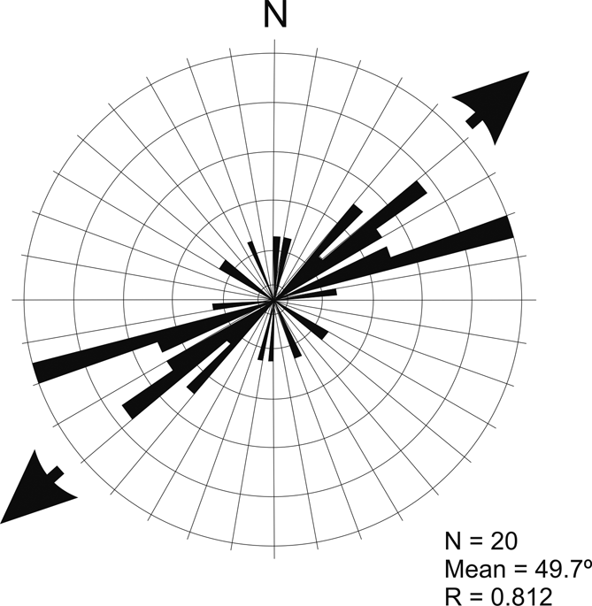
Figure 3 Rose diagram illustrating the orientation of horizontal and sub-horizontal tree casts and moulds in the Quinish Lava. Arrows indicate mean orientation. See main text for details and discussion.
Diameter. The Quinish trees range in diameter from 10 cm to 75 cm, with an average of 28 cm. Although the same lava is implicated, the locality in which they occur may be subdivided into two areas, the planated foreshore and minor crags close to the main tree cast (Specimen 1), and the cliffs near Dun Leathan (Fig. 1c). The trees at the former are larger, with diameters of 30–75 cm and an average of 55 cm, and those at Dun Leathan range from 10 cm to 37.5 cm, averaging 19 cm.
Position of the trees relative to the base of the Quinish Lava. Most of the prostrate tree moulds occur at Dun Leathan (Fig. 1c), where the enveloping Quinish Lava (Fig. 4) is of the order of 5–6 m thick. The moulds occur a short distance above the base of the lava and its underlying palaeosol (Fig. 4a). Height above the palaeosol varies from 20 cm to 1.6 m, averaging 88 cm. There is no apparent correlation between mould height above the palaeosol and mould diameter.
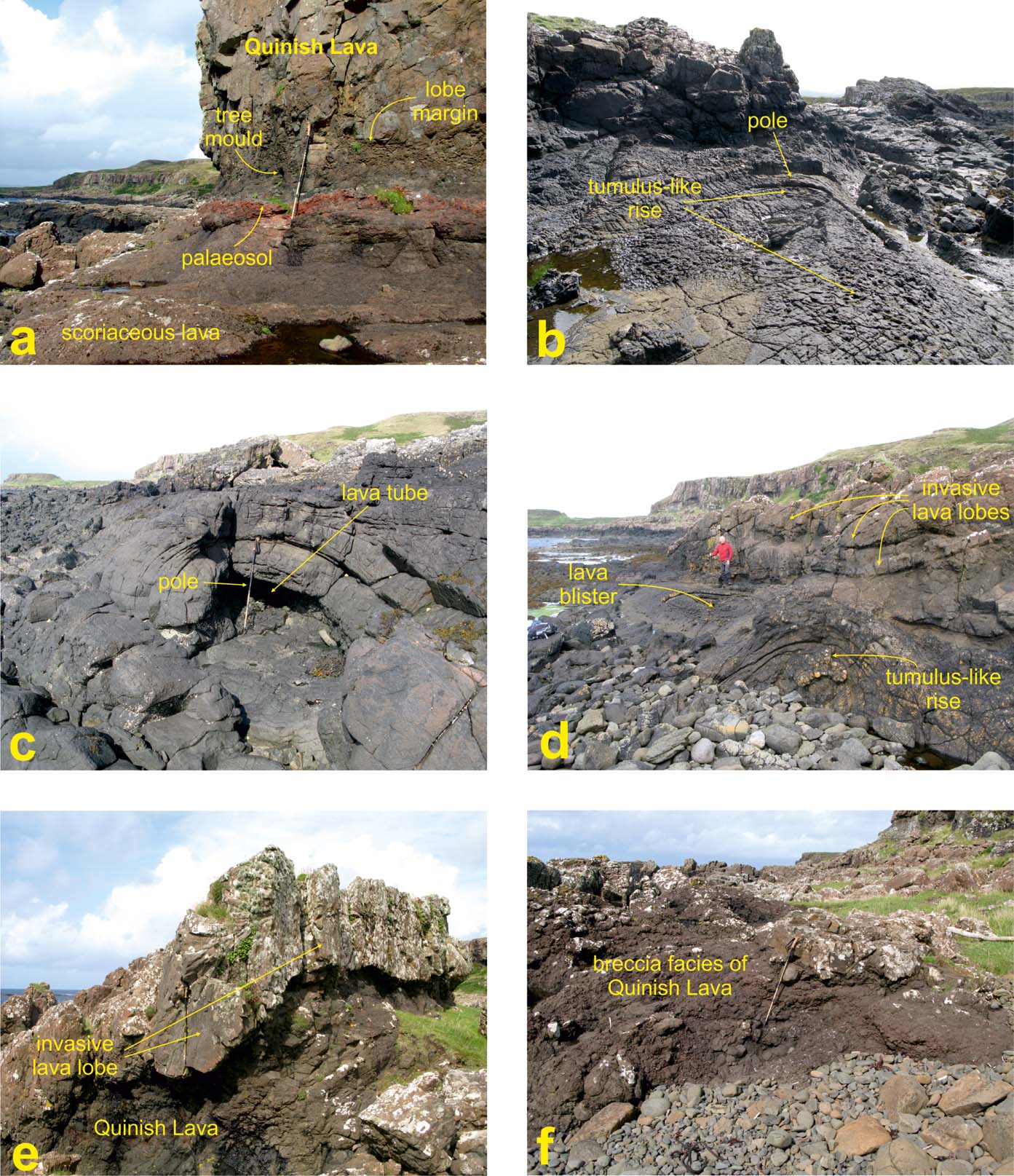
Figure 4 Features of the Quinish Lava, NW Mull [NM 41 56]: (a) palaeosol below Quinish Lava at Dun Leathan (between Localities 5 & 6); (b, c, d) internal features of the Quinish Lava; (e) subsurface invasive lava lobe within brecciated facies of the Quinish Lava; (f) breccia facies of Quinish Lava. See Figure 1c for locations and main text for descriptions and discussion. Scale: pole is c.1 m long.
Density. There is an insufficient population of confirmed in situ upright moulds that might otherwise have yielded a reliable estimate of forest density. Within a small area near the main tree cast, there are a few other circular or elliptical structures on the reddened surface of the underlying lava that might possibly represent the sites of in situ trees; five examples were seen but there may be more, hidden by intertidal vegetation. The average density of trees within this admittedly small area, which may represent a stand of trees isolated on the lava field surface, rather than part of a full forest covering a substantial area, is approximately 1/350 m2.
3.1.3. The Quinish Lava and associated lithologies
The lavas cropping out at Quinish are part of the MPLF and, although their exact stratigraphical position is uncertain, regional mapping (British Geological Survey 2013) suggests that they are within a few tens of metres of the local base of the formation.
The Quinish Lava crops out on the west side of the Quinish Peninsula in north Mull, north of Dun Leathan (at c.[NM 41 56]), over a distance of c.800 m (Fig. 1c). Many of the exposures occur on a rocky platform within the inter-tidal zone, together with some immediately above the High Water Line (Fig. 4). Several NW–SE-trending dykes belonging to the regional Mull Dyke Swarm dissect the lavas along this section of coastline. Crustal dilation data presented by Speight et al. (Reference Speight, Skelhorn, Sloan, Knapp and Sutherland1982) and Bell & Williamson (Reference Bell, Williamson and Trewin2002, fig. 14.19) show that the Quinish Lava is located relatively close to the central axis or zone of maximum dilation for this swarm (cf. Walker Reference Walker, Pritchard, Alabaster, Harris and Neary1993).
The state of preservation of the Quinish Lava, as well as the upper part of the underlying lava, is remarkably good (Fig. 4). Primary surface features and internal structures and textures bear closer resemblance to what are found typically in lavas from active volcanic areas such as Hawaii and Iceland. The Quinish Lava exhibits classic ropy pāhoehoe structures and shelly pāhoehoe crusts, both typical of lavas close to their point of eruption and where no fire-fountaining has occurred (cf. Cas & Wright Reference Cas and Wright1987).
Locally, the Quinish Lava shows relationships indicating that parts of it were intruded downwards, into the uppermost reddened and weathered portion of the underlying lava, with pipe-like masses of radially-disposed, columnar-jointed basalt (Fig. 4d, e). The margins of these invasive parts of the Quinish Lava are glassy (with selvages up to c.10 mm thick) and, in places, thin tachylitic veins penetrate the older lava, suggesting that cooling was very rapid and may have been aided by the presence of water.
Elsewhere, the Quinish Lava has a distinctly brecciated appearance (Figs 1c, 4f). In one area, measuring c.50 m by 6–7 m and located c.100 m north of Locality 1, the lava is up to 4 m thick and is composed of vesiculated (and more rarely amygdaloidal), sub-angular to sub-rounded clasts of basalt (Figs 1c, 4f). The clasts are remarkably sharp-edged, with little sign of weathering or abrasion, suggesting extremely rapid burial by the succeeding lava. The Quinish Lava, here, is clearly composed solely of scoria; there is virtually no matrix, other than a minor amount of zeolite and calcite mineralisation. The clasts are welded together, but show no obvious flattening. Further south, isolated areas of fragmented lava with a distinct 'flow' fabric may be related to this breccia facies. Overlying the Quinish Lava, where this main area of breccia occurs, is a thin vesicular basaltic lava, above which is a massive c.5–6 m-thick hawaiite lava that has a locally developed sub-horizontal fabric. This lava can be seen in the main crags above the High Water Line.
The lava that underlies the Quinish Lava is near-horizontal and has a reddened, scoriaceous, rubbly amygdaloidal and vesicular top (Fig. 4a). The surface texture is, in places, typical of an a'a flow, composed of chilled angular fragments of fine-grained to glassy basalt. The shapes of interstices between some of these fragments are typical of casts of shattered woody material or charcoal, although a complete lack of internal features and ambiguous external morphologies militate against conclusive formal identification (cf. Walker Reference Walker1962). Above this is a variable but generally well-developed palaeosol, or bole, produced by intense contemporaneous weathering and ferrallitisation processes and, where not removed by the action of the overlying (Quinish) lava, is up to 1 m thick (Fig. 4a). The palaeosol has a silty claystone character, being composed primarily of clay minerals, low-temperature iron and aluminium oxides, hydroxides and sesquioxides, together with small lithic fragments and diffuse streaks of carbonaceous material. Locally, this unit has a faint to moderately well-developed bedding-parallel lamination, suggesting a degree of transportation and sorting, most likely in an ephemeral low-energy fluvial or shallow lacustrine environment. The megafossils described in this paper occur either on the top of this lava and its palaeosol capping, typically as prostrate (horizontal) or vertical moulds and casts, or within the overlying Quinish Lava, as near-horizontal tree casts and tree moulds.
Our observations, along with published data from active volcanoes, have enabled us to form a picture of the lava field in the Quinish area involving a rapidly moving near-vent facies flow engulfing an established stand of trees. The Quinish Lava is a classic example of a pāhoehoe flow (or flow facies), with ropy upper surfaces, shelly structures with crusts, and internal (auto-intrusive) lava lobes and tubes (Fig. 4b–e), but also including localised sub-facies comprising brecciated (scoriaceous) material (Fig. 4e, f). Pāhoehoe characteristics may develop in vent-proximal facies, typically on gentle slopes. Shelly pāhoehoe structures form when gas-charged magma wells out of fissures, but without any significant fire-fountaining. The long axes of the ropes merely define local flow directions as the lava advances. The presence of tumulus-like structures (Fig. 4b, d) and partially filled lava tubes (Fig. 4c) indicates that the Quinish Lava roofed over and may have been capable of a significant flow length (several kilometres), due to the reduced heat loss (Peterson & Swanson Reference Peterson and Swanson1974). The flow entrained a significant number of tree trunks and branches, now preserved as tree casts and tree moulds (Fig. 2). The largest of the preserved trunks is a tree cast composed entirely of fine-grained, structureless basalt, which is capped by an accretionary (annular) basalt crust (Specimen 1 at Locality 1; Fig. 2a, b). This crust is contiguous with a steeply inclined linear zone of foliated lava, suggesting the location of a fissure-feeder structure, or bocca. Thus, we suggest that this tree may have toppled during the inflation of a fissure system during eruption.
3.2. MacCulloch's Tree
3.2.1. The Tree
MacCulloch's Tree, or the Fossil Tree of Burg, was first described by John MacCulloch in 1819, with further details presented by Bailey et al. (Reference Bailey, Clough, Wright and Richey1924) and Seward & Holttum (Reference Seward, Holttum, Bailey, Clough, Wright and Richey1924). It is located at [NM 4026 2784] on the west-facing coast of the Ardmeanach Peninsula in SW Mull (Figs 1, 5). Only the trunk of the tree has been preserved, there being no evidence of a root system, branches or canopy material. The trunk is in a near-vertical attitude within a thick basaltic lava, in part as a tree mould (Fig. 5a, b) and as mineralised woody matter and charcoal, accompanied by a complex assemblage of brecciated hydrothermal chalcedony and calcite (Fig. 5c, d; Table 1). It is exposed in a recess of the west-facing coastal cliffs of the Ardmeanach Peninsula near Burg (Figs 1, 5a). Since its discovery, a considerable amount of material has been removed by amateur and professional collectors and by geotourists, although not in more recent times, the locality having been afforded a measure of protection as a Site of Special Scientific Interest (SSSI) and situated on land owned by The National Trust for Scotland. Approximately 200 m further north, within the roof of a small sea cave, another (prostrate) portion of a fossil tree in the form of a section of a branch or thin trunk is preserved within vesicular brecciated lava (Fig. 1d, C) (Bailey et al. Reference Bailey, Clough, Wright and Richey1924). This remnant has a fibrous texture, now largely composed of soft clay or calcareous material.
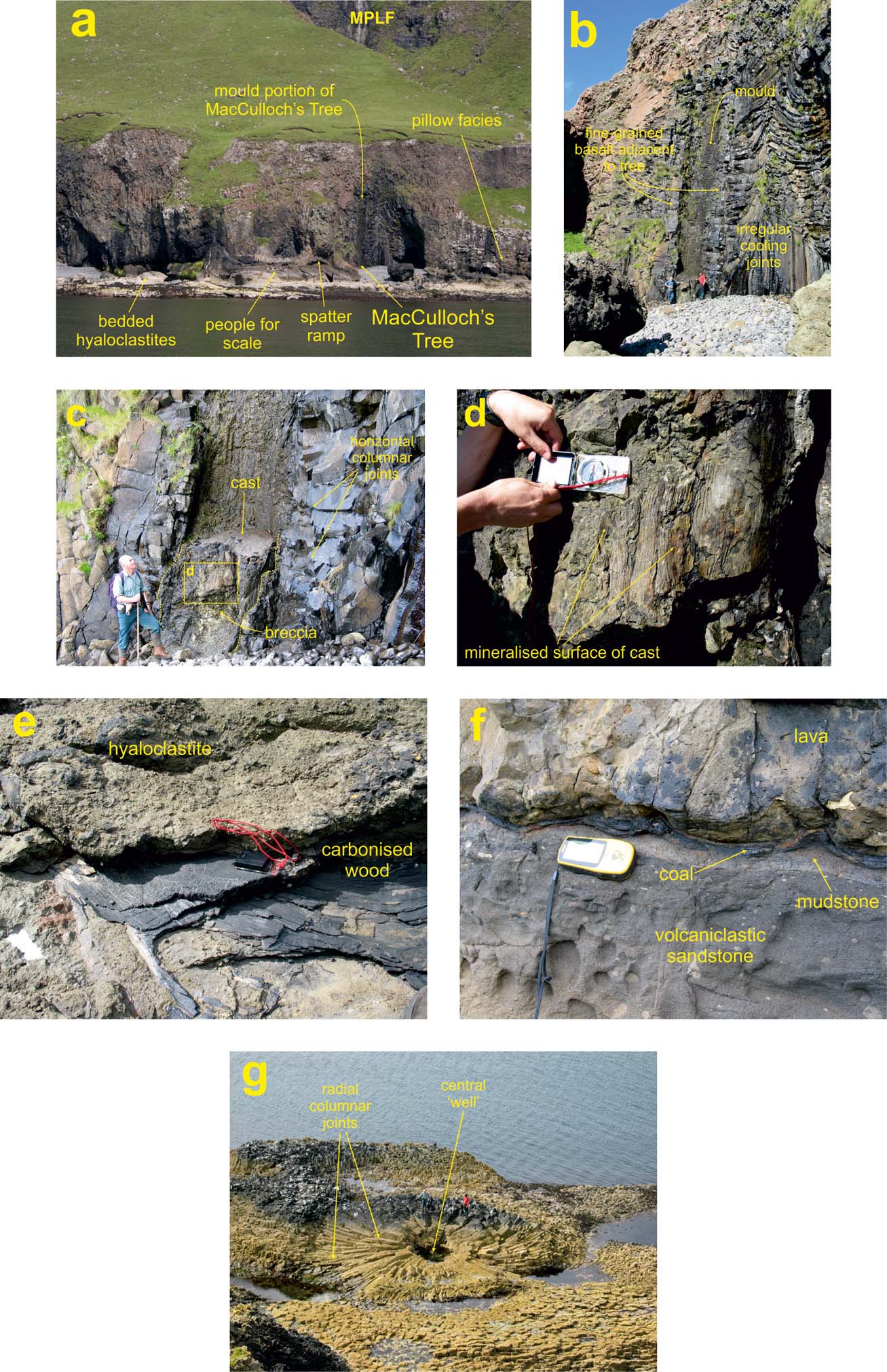
Figure 5 MacCulloch's Tree site, Ardmeanach Peninsula [NM 4026 2784]: (a) coastal section of the MacCulloch's Tree Lava, with location of tree indicated. Trunk is c.2 m in diameter and c.18 m tall (group of people on shore for scale); (b) MacCulloch's Tree, illustrating the remnant (cast) of the tree, together with the mould of the trunk, within the columnar-jointed (host) MacCulloch's Tree Lava; (c) Detail of the c.2 m-diameter cast of the trunk; (d) mineralised (chalcedony and calcite) surface detail of the trunk (compass is 10 cm long); (e) fragments of carbonised wood within the hyaloclastites underlying the MacCulloch's Tree Lava (compass is 10 cm long) (m2* on Fig. 1d); (f) thin beds of coal and mudstone overlying volcaniclastic sandstone/breccia sequence, overlain by the MacCulloch's Tree Lava (GPS is c.10 cm long); (g) radial columnar-jointed basalt south of MacCulloch's Tree [NM 4053 2699] (see Fig. 1d), interpreted as the (now) hollow location of a possible fossil tree (tree mould) that perturbed the cooling regime of the enveloping flow, resulting in the radiating joint pattern (people for scale).
3.2.2. The MacCulloch's Tree Lava and associated lithologies
The lava that engulfed MacCulloch's Tree was one of a series of major eruptions that produced a basin-wide flow field during the latter stages of emplacement of the SLF (Unit GS-A5 of Williamson & Bell Reference Williamson and Bell2012). The flow field crops out widely from Ardmeanach to Staffa and Ardtun, and beyond to the uppermost sections in the Brolass cliffs (Fig. 1d) giving it a potential volume possibly in excess of 4 km3. Though substantial, this is small in comparison to the famous 1783–84 Laki–Grímsvötn eruption, which produced 14.7 km3, and CRBG units commonly in excess of 1000 km3 (Thordarson & Self Reference Thordarson and Self1993; Bryan et al. Reference Bryan, Ukstins Peate, Peate, Self, Jerram, Mawby, Marsh and Miller2010). The MacCulloch's Tree Lava shows a complex relationship between several volcanic facies, which include columnar joints (commonly differentiated into classical colonnade-entablature pairings), large pāhoehoe lobes, auto-intrusive phenomena (including lava tubes, pillow lavas and breccias), hyaloclastites and flow breccias (Williamson & Bell Reference Williamson and Bell2012). Initially, it appears to have been erupted into a water body, most likely a shallow lake, with the resulting development of a delta-front complex of hyaloclastite, pillowed lava and breccia, and associated lava tubes. Therefore, the entombed trees may have grown, at least latterly, in a shallow-water environment, or they may have drowned in shallow lakes or ponds formed during flooding events induced by the damming or diversion of contemporary water courses during earlier phases of the same eruption.
The tree is near-vertical and is seen in vertical section (Fig. 5a–c). The lava in the immediate vicinity of the tree is massive, fine-grained basalt with prominent columnar joints, mostly in the style of an entablature; locally there is a relatively thin (underlying) colonnade. Adjacent to the tree, on both sides, is a zone, c.0.6 m wide, of relatively massive fine-grained basalt with poorly developed sub-horizontal joints. This extends up the tree mould to a height of c.7 m. Above this height, to the top of the tree at c.12 m, this zone is much reduced in width. On either side of and above the tree mould, the joints are more irregular and pass outward into the encasing lava as a series of stacked zones where, upon cooling, developing joint sets interacted with one another to produce entablature-like rosettes, fans and contorted chevrons (Fig. 5b).
Below the MacCulloch's Tree Lava, at and close to sea-level, is a thick heterogeneous sequence, comprising mudstones and siltstones containing carbonised woody fragments and trough cross-bedded volcaniclastic sandstones and basaltic hyaloclastites (Jolley et al. Reference Jolley, Bell, Williamson and Prince2009; Williamson & Bell Reference Williamson and Bell2012). The detailed nature, stratigraphical architecture, depositional environments and spatial distribution of these deposits, and of the lavas of the formation with which they are intimately associated, have been described in detail elsewhere (Williamson & Bell Reference Williamson and Bell2012). Here, we describe a thin coal and remnants of woody material within the more-arenaceous and argillaceous volcaniclastic deposits (Figs 1d, 5f). The top of this c.10 m-thick sequence of volcaniclastic deposits is typically marked by a thin (up to 1 cm) layer of coaly material (Fig. 5f), or is replete with granule- to sand-grade coaly or carbonised woody clasts (the lignite bed of Bailey et al. Reference Bailey, Clough, Wright and Richey1924). This facies crops out on the small headland north of MacCulloch's Tree, as well as directly below the lava in the sea cliffs south of the tree.
Immediately to the north of the promontory of Rubha na h-Uamha (Fig. 1d, m1*) there is a c.15 cm-thick lenticular mass of black, faintly laminated, carbonaceous mudstone, devoid of basalt clasts. The overlying volcaniclastic sandstones and siltstones contain clasts of mudstone, most likely of rip-up type. Above this is a 6–7 cm-thick volcaniclastic sandstone (localised, possibly deposited in a fluvial channel), laminated with lenticles of granule-size fragments of vesiculated (and amygdaloidal) basalt, overlain by a 1 cm thickness of carbonaceous mudstone.
At Rubha na h-Uamha (Fig. 1d, m2*), within the upper part of the sequence, are thin mudstone and siltstone beds containing carbonised/coalified wood fragments. Some of the woody fragments are remarkably large (see below), and are much broken and flattened, commonly with frayed or shattered ends (Fig. 5e). One poorly defined interval at m2*, 20–30 cm thick, is composed of disrupted laminated mudstone that contains carbonised woody fragments, with (approximate) dimensions of: 200 cm×20 cm; 80 cm×10 cm; 350 cm×50 cm; 40 cm×10 cm; 140 cm×20 cm; 40 cm×50 cm; and 130 cm × 55 cm (Fig. 5e). Well-developed, although localised, trough cross-bedding occurs within the hyaloclastite beds (H in Fig. 1d & Fig. 5a), directly below the mudstone and siltstone beds. The troughs are up to 6 m across and are inclined gently toward the north (toward 015–020°). Complex erosion surfaces and channel features are also present.
At the top of the sequence, on the promontory immediately north of MacCulloch's Tree, is a large ramp(art)-like structure composed of agglutinated spatter (S in Fig. 1d & Fig. 5a). The base of the MacCulloch's Tree Lava is deflected at this structure, which clearly indicates that prior to the eruption of the flow, a small vent, possibly temporally related to the eruption of the lava, was fountaining tephra onto the contemporaneous land surface. We speculate that this may be analogous to the situation described by Parcheta et al. (Reference Parcheta, Houghton and Swanson2012, fig. 9), who demonstrated an intriguing association between the formation of near-vent spatter ramparts and the presence of tree moulds during the 1969–1974 Mauna Ulu (Hawaii) eruption. Below the spatter rampart, subjacent to Macculloch's Tree, the fragmental rocks are very poorly sorted, with no evidence of reworking, and contain many excellent examples of cowpat and spindle bombs, together with lava rags.
To the south of MacCulloch's Tree, on the wave-cut platform between Dearg Sgeir and Carrachan Mor (Fig. 1d), a spectacular exposure of radiating columnar joints may indicate the location of another fossil tree within the MacCulloch's Tree Lava (Fig. 5g). Located within the upper (entablature) portion of the lava, this structure comprises a central ‘well’ that may mark the position of a vertical tree mould, surrounded by lava within which the cooling joints have developed at right angles. This is almost identical to the architecture of the lava at MacCulloch's Tree, but here seen in plan view rather than in vertical section. Alternatively, the structure may represent a sub-horizontal section through a later (auto-intrusive) vertical feeder tube. The lava top dips gently to the SE, disappearing below sea-level beyond Carraig a' Mhinisteir, some 1.5 km SSE of MacCulloch's Tree.
The so-called Tavool Tree, exposed farther south and east, on the north shore of Loch Scridain south of Tavool House (Fig. 1d), comprises several fragments of carbonaceous woody (possibly coniferous) material up to several centimetres long, within altered vesicular or brecciated lava (Bailey et al. Reference Bailey, Clough, Wright and Richey1924). The overlying lava has well-developed two-tier columnar joints and may correlate with either the MacCulloch's Tree Lava or the lava above it.
3.3. The Carsaig Tree
3.3.1. The Tree
The Carsaig Tree (Williamson & Bell Reference Williamson and Bell2012) is exposed in the cliffs above the Carsaig Arches on the south side of Brolass on the Ross of Mull, SW of the triangulation station on the cliff top some 350 m SE of Loch na Gaidheal (at c.[NM 4915 1875]) (Figs 1d, 6a). This tree cast appears to be composed entirely of a near-vertical tube of fine-grained aphyric basalt, although only the lowest 3 m is accessible to direct study (Fig. 6a). Its overall form is reminiscent of MacCulloch's Tree, but there is neither relic organic matter nor mineralisation present.
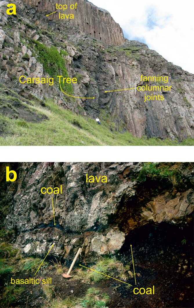
Figure 6 The Carsaig Tree, cliff at Carsaig Arches, Brolass, Ross of Mull (peninsula) [NM 4915 1875]: (a) the Carsaig Tree, a c.2.5 m-wide and c.14 m-tall cast, set within a columnar-jointed basaltic lava, within the cliff section c.300 m NW of Carsaig Arches (Fig. 1b). The columnar joints near to the cast are deflected, inferring that the enveloped tree modified isotherms, causing joints to develop orthogonal to the trunk (person for scale); (b) disrupted coal-mudstone unit below the Carsaig Tree Lava. The sedimentary sequence is intruded by a thin basaltic sill, possibly related to the overlying columnar-jointed lava. Hammer shaft is approximately 30 cm long.
3.3.2. The Carsaig Tree Lava and associated lithologies
The Carsaig Tree Lava lies stratigraphically midway within the SLF (sequence GS-A4 of Williamson & Bell (Reference Williamson and Bell2012)) and consists of at least 14 m of columnar-jointed basalt with a 1–2 m-thick scoriaceous blocky top; the blocky facies also ‘caps’ the tree cast. The lava appears to have ponded in a local depression and was most likely emplaced rapidly as a highly fluid, voluminous pāhoehoe sheet. The basalt adjacent to the cast, and for 0.25–0.5 m further outward from it, is vesiculated, with the long axes of individual ovoid vesicles aligned vertically, sub-parallel to the cast. The otherwise near-vertical columnar joints (of typical colonnade style and spacing) within the lava take on locally radial or fan-shaped forms on both sides of the cast, with vertical columns originating at the base of the lava deflected by the cooling surface the tree offered, curving to the sub-horizontal adjacent to it (Fig. 6a). The base of the lava is not exposed below the cast, but a few metres to the west it is gently undulating and sharp, with a lobate tongue of chilled, in places invasive, basalt.
The lava overlies a few centimetres of a brown coal–siltstone–mudstone sequence, laid down in a shallow lake or mire, possibly in an overbank riparian setting (Williamson & Bell Reference Williamson and Bell2012). It is intruded by a thin basaltic sill (Fig. 6b).
4. Palaeobotany and palaeoenvironments
4.1. Identifying tree affinity
The identity of the fossil trees described from Mull cannot be established through the examination of simple moulds and casts alone; attribution may be attempted, however, through studying preserved woody tissues (permineralised or as charcoal), and macrofossils and microfossils in associated inter-lava sedimentary units. It is informative, when considering the taxonomy of these fossils, to also consider the post-discovery history of palaeobotanical research on MacCulloch's Tree.
MacCulloch's Tree is the specimen for which we have most information. This tree alone has been partially preserved as both permineralised (silicified) wood and an outer annulus of (lignitised) wood and charcoal. This material is no longer exposed. Both MacCulloch (Reference MacCulloch1819) and Geikie (Reference Geikie1897) simply referred to it as a species of fir, and Gardner (Reference Gardner1887) considered it coniferous, possibly Podocarpus. However, it was not until the official geological survey of Mull by Bailey et al. (Reference Bailey, Clough, Wright and Richey1924) that a more informative study was made.
Examination of preserved anatomical features (e.g., annual rings, medullary rays, resinous xylem-parenchyma, tracheids, etc.) proved sufficient for Seward & Holttum (Reference Seward, Holttum, Bailey, Clough, Wright and Richey1924) to confidently assert that the tree was a conifer of the fossil genus Cupressinoxylon, Earlier, Seward (Reference Seward1919) had stated that there was no significant difference between Cupressinoxylon and Taxodioxylon and considered that the latter, along with Glyptostroboxylon, should be taxonomical synonyms for Cupressinoxylon. Hence, the tree's attribution by Seward & Holttum (Reference Seward, Holttum, Bailey, Clough, Wright and Richey1924) to Cupressinoxylon did not disqualify it from belonging to one of those genera. The tree was still viewed as Cupressinoxylon by Emeleus & Gyopari (Reference Emeleus and Gyopari1992), but subsequently deemed Taxodioxylon (D. Jolley, pers. comm. 1999) (Emeleus & Bell Reference Emeleus and Bell2005; Williamson & Bell Reference Williamson and Bell2012).
Volcaniclastic strata cropping out below the MacCulloch's Tree Lava were studied by Williamson & Bell (Reference Williamson and Bell2012) and judged to have been deposited in lacustrine and marginal fluvio-lacustrine settings. The sequence, although dominated by hyaloclastites, also carries evidence of reworking (channels, slump-bedding, cross-bedding), periodic emergence (fresh scoria, spatter, magma rags) and low-energy conditions (lenticular beds of siltstone-mudstone). These strata, including a thin carbonaceous top bed, are impoverished or barren of palynomorphs, yielding only large inertinite fragments (D. Jolley, pers. comm. 1999). In contrast, a carbonaceous mudstone lens at the same stratigraphical level, from Rubha na h-Uamha north of MacCulloch's Tree, yields a surprisingly rich palynoflora of terrestrial origin (Jolley et al. Reference Jolley, Bell, Williamson and Prince2009). The dominant taxon here is derived from swamp cypresses and Metasequoia (Inaperturopollenites hiatus) suggesting, on this basis, that trees with affinities to Taxodioxylon were prominent features in the ecosystem. Together, the association of this palynological evidence and the tree's large monopodial trunk raises the possibility that MacCulloch's Tree might, along with the other woody macrofossils found nearby, be conifers in the Taxodiaceae. Few extant members of this group are either flood-tolerant or can grow in wet or waterlogged soil or in the shallow freshwater, lowland wetland habitats suiting Taxodium (and Glyptostobus). It is also debatable as to whether the pollen of Inaperturopollenites hiatus is distinctive enough to assert, with any confidence, that MacCulloch's Tree (and others, see below) is related to the modern swamp cypress (Taxodium distichum) or Metasequoia. Modern swamp cypresses possess well-developed woody flanges or buttress-like structures extending outwards from their lower trunks as adaptations to the low-oxygen conditions prevalent in swamp and flood-prone habitats. These are not a feature of MacCulloch's Tree, and so its identification remains equivocal.
Recent molecular phylogeny studies (e.g., Mao et al. Reference Mao, Milne, Zhang, Peng, Liu, Thomas, Mill and Renner2012) have shown that some Taxodiaceae are more closely related to various Cupressaceae than others, with the result that the two families are now grouped collectively in the Cupressaceae. Another factor when considering the likely affinity of these trees is the very widespread distribution of Glyptostrobus (Cupressaceae) during the Cenozoic (e.g., LePage Reference LePage2007). This, coupled with the presence of its pollen and foliage elsewhere in the MLF (Boulter & Kvacek Reference Boulter and Kvacek1989; Jolley et al. Reference Jolley, Bell, Williamson and Prince2009), makes such attribution also a possibility. A more specific identification of this remarkable tree is likely to remain elusive and speculative, pending a future study that includes detailed examination of the remaining, but at present inaccessible, woody and mineralised tissues.
The Carsaig Tree is the cast of a large trunk, encased upright within columnar-jointed basalt. Unlike MacCulloch's Tree, no fossilised woody tissues, by which it might be identified, remain. Only indirect data supplied by palynological and sedimentological studies of the underlying sedimentary sequence furnish any clue. Pollen assemblages, though poor, are, similar to those at the MacCulloch's Tree site, dominated by Inaperturopollenites hiatus, likely derived from upland Taxodiaceae trees, together with allochthonous Pityosporites, the fern Deltiodospora adriennis and Tricolpites spp. (Jolley et al. Reference Jolley, Bell, Williamson and Prince2009; Williamson & Bell Reference Williamson and Bell2012). The same caveats as to affinity and the status of Inaperturopollenites hiatus pollen concerning MacCulloch's Tree apply here also. The presence of coals in the strata directly beneath the tree confirms the former existence of swamp or mire communities, and strongly suggests that the tree was adapted to wet or flood-prone conditions; e.g., as a form of swamp cypress.
The preservation of the Quinish trees solely as moulds and casts renders discussion as to their affinity speculative at best. Any attribution is necessarily dependent, therefore, on indirect evidence such as the palynological signature of associated sediments and palaeosols, inferences drawn by comparing fossil form and dimensions with those of trees of living genera and a consideration of wider environmental factors prevailing on the lava field at the time.
The environmental conditions under which these trees grew may also furnish indirect evidence as to their affinity. The well-developed lateritic palaeosol beneath the Quinish Lava contrasts markedly with the strata associated with MacCulloch's Tree and the Carsaig Tree. These latter substrates suggest swampy wetland and lake-marginal or flooded environments, whereas the Quinish palaeosol reflects intensive, deep weathering of basalt in a more terrestrial setting. The presence of distinct horizons within the palaeosol is typical of in situ illuvial pedogenic profile development in a drier, better drained, possibly more upland environment lacking any long-term standing water, but with alternating wet and dry conditions. This contrast in environments suggests that the Quinish trees (assuming limited tree diversity) may be different to those at Burg and Carsaig. However, this need not be so. Most Taxodiaceous trees are not flood tolerant, the modern swamp cypress (Taxodium distichum) for example, although favouring riparian settings, is known to grow well and faster on moist, well-drained soils (e.g., Gilman & Watson Reference Gilman and Watson1994).
Palynological data is currently lacking for the Quinish site, but wider palynological studies from across the HIP lava fields (e.g., Skye (Jolley Reference Jolley and Widdowson1997), Mull (Jolley et al. Reference Jolley, Bell, Williamson and Prince2009) and Rum (D. Jolley pers. comm. 1999)) demonstrate that many areas were dominated by Metasequoia. It is not inconceivable, therefore, given its straight, monopodial habit, that the principal tree at Quinish is of this type. Alternatively, this and the other trees could conceivably belong to members of the Juglandaceae (walnut, hickory, etc.) and form part of a mixed mesophyte assemblage of upland conifers and broadleaved trees, as is prevalent in parts of the SLF (Jolley et al. Reference Jolley, Bell, Williamson and Prince2009; Williamson & Bell Reference Williamson and Bell2012). No macroflora, such as leaf imprints have, to date, been discovered in the palaeosols of the Dun Leathan sections at Quinish, suggesting that during the eruption of the Quinish Lava, topsoil and forest litter were efficiently removed or consumed by the candescent lava; similarly, the forest canopy (thin branches, remaining leaves etc.).
4.1.1. Forest community. The forest ecosystem of which MacCulloch's Tree was a part most likely established quickly, reaching maturity within a relatively short period. The successional sequence would have been facilitated greatly, in the warm climate of the time, by a rapid breakdown, weathering and decomposition of the volcaniclastic and pyroclastic substrate to produce viable fertile soil. This process would have produced a high-biomass tertiary vegetation community more quickly than on relatively smooth, pāhoehoe-textured (lava) tops.
That a relatively high biomass could be achieved with equivalent taxa and growing on non-volcanic substrates during the mid-Palaeocene has been demonstrated by the work of Williams et al. (Reference Williams, Johnson, LePage, Vann and Taylor2003, Reference Williams, LePage, Johnson and Vann2009) on Ellesmere Island, Canada. The Burg trees, along with shrubs and a fern understorey (Jolley et al. Reference Jolley, Bell, Williamson and Prince2009), would have been devastated by the MacCulloch's Tree Lava as it progressed across a swampy floodplain and small lake complex, the fringes of which they vegetated. The larger mature trunks and branches of the forest were incorporated into the flow and, ultimately, preserved as woody petrifications (fossil trees), tree casts or tree moulds.
The local forest density figure of 1/350m2 noted earlier (section 3.1.2) for the Quinish site is considerably lower than the 1/20m2 and 1/60m2, respectively, for the Takapuna and Ihumatao Fossil Forests near Auckland (Hayward & Hayward Reference Hayward and Hayward1995), but compares well with data from Parcheta et al. (Reference Parcheta, Houghton and Swanson2012). The latter authors, researching the 1969–1974 Mauna Ulu eruption of Kilauea, counted the number of pre-eruption trees and resultant tree moulds. Based on the numbers quoted and the distribution they illustrate (Parcheta et al. Reference Parcheta, Houghton and Swanson2012, fig. 4), we estimate that the original Quinish stand had a density of c.1/45m2, whereas the tree moulds have a density of c.1/385m2; only a little over 11 % of the original trees survived as moulds.
4.1.2. The age of the trees. The growth of the trees was the final element in a complex and protracted timeline of events and processes that would have taken place on the lava field during a period of quiescence prior to the eruptions that killed them. Further aspects are considered in section 5. Establishing the lifespan of a (fossil) tree would provide a minimum duration for this latter part of the sequence. With caveats, we have assumed that age estimation through comparison with related extant taxa is valid and that the trees most likely have affinity to Metasequoia or Taxodium (as discussed).
Comparison of the dimensions of the trees with those of, for example, extant Metasequoia glyptostroboides (dawn redwood) and Taxodium distichum (swamp or bald cypress) trees, indicates that these large fossil trees were well-established and mature specimens at the time of their death. Some of the larger extant Chinese specimens of Metasequoia glyptostroboides, for example, measure c.50 m (height)×c.2–2.2 m (diameter) and, given an average annual growth rate of 30–80 cm vertical and 1–1.75 cm diameter, may be at least 100 years old (Chao Chin Ju Reference Chao1984). In a study of ancient bald cypress, Stahle et al. (Reference Stahle, Burnette, Villanueva, Cerano, Fye, Griffin, Cleaveland, Stahle, Edmondson and Wolff2012) reported age spans of centuries to even a millennium. On such a basis, MacCulloch's Tree, a little over 1.5 m in diameter (c.5 m circumference), may have attained an original height of c.40 m (cf. Williams et al. Reference Williams, Johnson, LePage, Vann and Taylor2003; Davies-Vollum et al. Reference Davies-Vollum, Boucher, Hudson and Proskurowski2011); dimensions consistent with an age range of at least 50–70 years. Similarly, the Carsaig Tree (c.2.5 m diameter and c.8 m circumference) conceivably had an original height of 50–55 m, and was at least 100–110 years old. The principal Quinish tree is smaller (diameter of c.0.75 m) but probably reached an age of several tens of years before it was engulfed by lava; the smaller moulds, if considered trunks of the same species rather than major boughs or branches, would represent much younger trees. The absence of annual tree-rings precludes charting variations in growth rate imposed by the Palaeocene climate, and in such local environmental factors as hydrology, population density, competition, disease, predation and nutrient levels.
Depending upon its position (proximal, medial or distal) relative to the vent, availability, levels and fluxes of key nutrients within a newly forming plant community would have varied considerably. It is generally assumed that the growth of trees such as we describe here must have been compromised by their proximity to the polluting effects of active volcanism. If this were the case, then using data from extant taxa growing in non-volcanic (and therefore presumably more benign) areas would result in an over-estimation of the ages of the fossil trees. However, the palynology of associated strata shows that the Mull trees were likely part of high-biomass (and therefore thriving) ecosystems. Such a possibility is supported by a study of volcanogenic nutrient fluxes in plant ecosystems in a large igneous province such as the CRBG (Jolley et al. Reference Jolley, Widdowson and Self2008). This study demonstrated that volcanic gases and the breakdown of volcanic products and meteoric waters can supply sufficient nutrients to support high-productivity ecosystems during significant breaks in volcanism.
Our lifespan estimates for the Mull trees are necessarily tentative. The trees may not have been first-generation, but survivors from kipukas (refugias, or areas of land with a relict population surrounded by a lava), bypassed and not destroyed by earlier lavas, and the fluxes in environmental conditions at both the local and regional levels, are unknown. Hence, pedogenesis and the subsequent establishment of the successional pathways necessary to achieve mature woodland or forest must have developed over similar or, more likely, longer time spans.
4.1.3. Aspects of preservation. The combined woody and permineralised preservation of MacCulloch's Tree may provide evidence of its state upon burial. It is generally assumed to have been alive at the time; this is not only difficult to prove, but its setting and the nature of preservation could also indicate that it was severely weakened or already dead.
The lithofacies and palynological signatures of the underlying (sedimentary) rocks, together with the presence of hyaloclastites and pillow-lava, points to a flooded marginal riparian or shallow lacustrine depositional setting. Forests growing in such environments naturally also include dying (still upright) and fallen trees that become waterlogged. We contend that MacCulloch's Tree may have been one such tree; it was almost certainly taller than its preserved height (see earlier), and there are no indications of a surviving canopy, which must have been substantial. This may have been consumed by fire during the eruption but, equally, if dead or under extreme environmental stress, the tree may have been denuded already. For cellular woody tissue to survive being buried by basaltic lava at several hundred degrees Celsius and the protracted cooling process of such a thick lava, the tree would have to avoid being consumed entirely. This would only be achieved in the absence of oxygen, either through the tree being buried entirely by a single flow unit (i.e., effectively sealing it off from the atmosphere), or through the initial insulating effect of waterlogged tissues, allowing further insulation of the core by an annulus of chilled basalt, or a combination of both.
Some supporting evidence for this comes from the work of Garland et al. (Reference Garland, Bannister, Lee and White2007), who considered the possibility that the mineralisation and exceptional preservation of a Jurassic Podocarpaceae conifer entombed in the Ferrar Lavas of Antarctica was due to the tree having been partially decomposed, or possibly waterlogged, prior to the eruption that engulfed it.
The fossilisation process for the Carsaig and principal Quinish trees is very different from that of MacCulloch's Tree. For initial mould formation (subsequently infilled by fluid basalt to produce the casts we see today), the original tissues of both trees had to have been completely obliterated. For this to happen, a constant supply of oxygen would have been needed. We surmise that the Carsaig Tree may not, therefore, have been fully buried by the flow that inundated it and that, projecting above the lava surface and therefore open to the atmosphere, the trunk continued to burn vigorously after the surrounding flow had solidified.
For the main Quinish tree, it was the open nature of the volcanic substrate (partially a scoriaceous breccia) and flow-type that facilitated total incineration prior to infilling of the mould.
5. Refining flow emplacement and environmental models
The diverse range of plant macro- and micro-fossils preserved in the sedimentary units of the SLF clearly establishes that forests and woodlands at various stages of ecological succession grew on and adjacent to the MLF during the more protracted periods of volcanic quiescence. The fossil trees we describe here are not only of palaeobotanical interest, but have additional significance as they are found within ‘magma’ rather than ‘sediment’, so offering insights into the nature of the accompanying volcanism. They enable appraisal of such parameters as eruption frequency, lava facies architecture and emplacement mechanisms, and a refinement of modelling by contrasting environmental conditions under which the two main volcanic formations (SLF & MPLF) evolved.
5.1. Frequency of volcanism and the duration of quiescence
Periods of volcanic quiescence are common features of a developing lava field, allowing weathering and soil formation to take place and devastated ecosystems to recover. Periodicity of present-day volcanoes with fissure-fed systems is highly variable. Iceland, for example, averages 20–30 volcanic eruptions per century (Thordarson & Larsen Reference Thordarson and Larsen2007) and even a climate more conducive to the development of diverse forest communities than at the present day, would leave little time for significant widespread ecosystem recovery. Historically, inter-eruption intervals may last hundreds of years, with the longest commonly following larger-than-average eruptions (e.g., Reference KleinKlein 1982; Gudmundsson Reference Gudmundsson1998).
The lifespans of the large trees on Mull would certainly inform debate as to the duration of respective interludes by providing low-end estimates, likely in the order of several decades, or more. Such estimates include neither the lengthy period preceding the growth of the trees, nor any variation in tree growth rates. These unknown quantities, strongly influenced by local and regional climate, aridity, hydrology, the effects of nearby active volcanism, proximity to forested refugia, topographic and other orthographic effects, etc., would extend any timeline significantly. If seeds were sourced from nearby forested refugia, however, then it is possible that by their establishment in fissures where rock debris and water would accumulate (thus bypassing the early stages of biotic colonisation), the timeline will be closer to the tree's age.
An additional factor potentially extending the timeline is that the trees in question may have been already dead (e.g., drowned by an earlier flooding event, or killed by disease or in a forest fire). Furthermore, the final dimensions of a tree may be attained many years (possibly decades or more) before its death. Thus, a 40 m-high tree might have matured within 100 years but be considerably older at the time of death.
The size and age of the Mull trees indicates that local ecosystems had advanced beyond the early successional stages and had culminated in semi-mature to mature forest habitats. At Quinish, association with a thin, in situ, lateritic palaeosol facies (bole) (see, for example, Bell et al. Reference Bell, Williamson, Head and Jolley1996, and references therein) further indicates that there had to have been a considerable period of weathering and soil formation prior to the growth of the trees.
Today, laterite forms most readily in the tropics. However, the diverse biota of the MLF is mostly characteristic of a warm-temperate palaeo-climate. Only in assumed low-lying and sheltered areas in the SLF is there evidence for sub-tropical conditions (Williamson & Bell Reference Williamson and Bell2012). This apparent contradiction is likely due to an acceleration of the weathering and soil development processes imposed by the elevated thermal regime of the volcanic terrain. Estimates of the time taken for lateritic soil to form on some basaltic lava fields, for example the CRBG (Sheldon Reference Sheldon2003, Reference Sheldon2006a) and Hawaii (Sheldon Reference Sheldon2006b), range from a few hundred years to a few thousand. Comparison would potentially extend the MLF hiatuses discussed here to several hundreds of years.
5.2. Facies architecture and emplacement of associated lavas
The Quinish Lava bears the hallmarks of a typical, moderate-volume pāhoehoe flow developing as part of a classic compound-braided facies suite, whereas the lavas at Burg (MacCulloch's Tree) and Carsaig are considerably more voluminous and belong to the tabular and ponded facies type. Fossil tree data may be used to define flow parameters such as flow type and flow direction, and help refine emplacement modelling.
5.2.1. Quinish trees – flow type
At Quinish, most of the prostrate tree moulds lie within the lowermost 25–30 % of the Quinish Lava, seldom at its base, a position consistent with the flow being of pāhoehoe type. Observations on modern volcanoes reveal how this happens. A tree simply bulldozed by an advancing flow front, and then buried beneath the encroaching flow, would ultimately lie very near to the flow base. This would happen most readily with an aa-type lava. Where the flow structural type is pāhoehoe, fluid magma surrounds the tree's base to a variable depth. As the tree's lower parts are consumed, the weakened and unsupported trunk eventually falls onto the still molten surface, but only partially sinks; Walker (Reference Walker1995), for example, quotes depths of only 10–20 cm for even heavy trees. The resultant mould then comes to lie above the flow base, possibly at the interface between the first and a second (more voluminous) flow lobe that buries it completely.
The lack of significant deformation of these fossils indicates that the original trunks and branches either remained in place, or were transported only short distances within the flow until it froze; or that where woody material was completely consumed, the resultant moulds maintained their rigidity after being passively engulfed. If the lava had continued to move for a protracted length of time, thereby covering a considerable distance after eruption, many of the moulds would most likely have been (mechanically) destroyed (Lockwood & Williams Reference Lockwood and Williams1978). Their preservation implies that flow ceased soon after the trees were engulfed. In addition, the positioning of in situ stump casts near to the base of the Quinish Lava is evidence that most were well-rooted in the palaeosol and/or in fissures in the underlying lava. The wider extent of this putative stump-field is unknown, the horizon passing below sea level to the west, and overlain by the Quinish Lava and Quaternary deposits, inland to the east.
No correlation between mould position (above the palaeosol), shape or diameter was found, suggesting that weight played no significant part. Rather, the observed variations more likely reflect the thickness of the initial flow unit/lobe onto which the trees fell, before their complete burial by the subsequent unit. A complication to this simple model is the positioning of a cluster of moulds seen at Dun Leathan (Fig. 2f). Rather than individual trunks, these may represent branches of a single tree. Similar features are recorded from several other volcanic fields; for example, Hawaii (Walker Reference Walker1995), Iceland (Sigurgeirsson & Jacobsson Reference Sigurgeirsson and Jacobsson1997) and the CRBG (Self et al. Reference Self, Thordarson, Keszthelyi, Mahoney and Coffin1997). Observations of forest–lava interaction on active volcanoes (Walker Reference Walker1995) have shown that, for pāhoehoe flows, this correlates well with the height attained by the initial pulse (flow lobe) of magma. Examples from the Roza Member of the CRBG, as illustrated by Self et al. (Reference Self, Thordarson, Keszthelyi, Mahoney and Coffin1997, fig. 4), also show this feature.
5.2.2. Quinish trees – flow direction
Although the mould/cast mode of fossilisation is seen elsewhere within the MLF and within the wider HIP, the Quinish locality is unique because it is the oldest known example we are aware of where several prostrate and upright trees occur within a single lava, within a relatively small area and in such proximity to one another. Another intriguing feature of the prostrate Quinish specimens is their preferred orientation (Fig. 3), and this has significant implications when considering the likely emplacement of the Quinish Lava.
The simplest explanation assumes that orientation reflects the direction of flow, the trees falling forwards (or backwards) and without rotation, either during the initial lava incursion, during magma drawback or, for prostrate (fallen) examples, during advance of a second lava unit. The further and more vigorously the trees are transported at the edge of a complex flow-front, or by a later flow unit, the more likely is their rotation and realignment.
Alignment of sub-horizontal tree moulds has been recorded only rarely from other ancient lavas. Most moulds noted by Wilkinson & Allen (Reference Wilkinson, Allen and Wilkinson1959) in the CRBG are aligned east–west, suggesting a relationship (not specified) with flow direction. Compelling evidence for a direct relationship comes from the observations of Hayward & Hayward (Reference Hayward and Hayward1995) and Walker (Reference Walker1995). Working on the Pleistocene lava and tree remains at Takapuna, Auckland, New Zealand, the former observed that most prostrate moulds aligned in the direction of flow. Similarly, an investigation by Walker (Reference Walker1995) of over 100 sub-horizontal moulds within a single, historically active pāhoehoe flow from NW Hawaii, demonstrated that two-thirds of them are oriented within 65° of the flow's dip direction, presumably therefore broadly its flow direction.
A good example of where lava has been observed actively invading a forest, and therefore a suitable model for the Quinish trees, is the ongoing Pu‘u ‘Ō‘ō (Kīlauea) eruption on Hawaii (e.g., Orr et al. Reference Orr, Heliker and Patrick2012). An examination of aerial photographs of the flow (HVO-USGS 2016) shows that although the picture is a dynamic one, at any one time most (trees) readily fall in the direction of flow as the flow-front encounters the forest. This direction is controlled by the primary topography and is downslope of the vent or fissure system. As this pāhoehoe flow has developed, it has widened, with breakout units and secondary lobes spreading laterally and becoming captured by minor hollows in the topography; fallen-tree azimuths in these areas are often markedly different from those defined by the main flow. In places, the surface of the flow is littered with fallen and unburnt trees, many showing less of a preferred orientation. This appears to happen more frequently when the flow is relatively slow-moving, and only thick enough to surround the lower trunks, rather than knock them over. The trees only topple onto the lava surface once their base and lower trunks have been burnt through, by which time flow has ceased and an upper crust has formed, parts of which have cooled sufficiently so as not to burn the remains. A subsequent slow-moving flow-unit passively burying these trees would likely preserve the initial orientation, whereas a more vigorous unit may result in reorientation. Any alignment of moulds noted from a single, restricted exposure can therefore be a guide as to flow direction and palaeo-slope, but only at the local scale. Consequently, caution is required when investigating the wider regional aspects of volcanism on ancient lava fields.
These observations have a direct bearing upon our interpretation of the Quinish data. The lava within which the Quinish trees are found crops out near to, but just west of, the central axial zone of the predominantly NW–SE-trending regional Mull Dyke Swarm (Speight et al. Reference Speight, Skelhorn, Sloan, Knapp and Sutherland1982; Bell & Williamson Reference Bell, Williamson and Trewin2002; Emeleus & Bell Reference Emeleus and Bell2005). These dykes are interpreted as being the intrusive expression of the original fissure feeder system to the lavas, and uplift along the zone would have resulted in primary palaeo-slopes developing mainly to the SW and NE. The physical features of the Quinish Lava, and the substantial number of dykes in the area, suggest that it was vent/fissure proximal. Parcheta et al. (Reference Parcheta, Houghton and Swanson2012) have shown that initial flow, near a fissure and prior to the lava being ‘captured’ and redirected by local topography, is commonly more or less perpendicular to the source. We may conclude, therefore, that the dominant SW–NE orientation of the Quinish moulds reflects a regional palaeo-slope most likely to the south-west and, consequently, determining the direction of flow of the Quinish Lava.
5.2.3. MacCulloch's Tree and the Carsaig Tree – flow type
Physical features of the lavas associated with these two megafossils are presented in section 3.2.2, and suggest that both were particularly voluminous and had ponded within the local topography prior to cooling under static conditions. The depth to which the associated trees were buried (MacCulloch's Tree c.12 m; Carsaig Tree c.14 m), whilst remaining vertical, is a useful additional clue as to lava type and emplacement style.
Exposures of both lavas near to the trees show neither internal cooling surfaces, with or without the presence of horizontal tree moulds, nor vesiculation patterns consistent with the build-up of successive pāhoehoe sheets or flow lobes. Rather, the trees were overwhelmed by seemingly compositionally and structurally uniform lavas, which achieved thicknesses equal to or greater than the heights of the trees. For this to happen, we contend that these lavas most likely ponded, or possibly spread very rapidly as single, low-viscosity, high effusion rate, sustained laminar sheet-flow eruptions.
It is generally held that being preserved upright, both MacCulloch's Tree and the Carsaig Tree were alive at the time of eruption and remained in situ. In the case of MacCulloch's Tree, the lack of both a root system commensurate with its size and assumed maturity, and a significant palaeosol, is enigmatic and may suggest otherwise. The tall, upright nature of these trees and the structure of the lavas around them suggest ponding of the flows and the extremely rapid burial of the trees. Intuitively, it seems implausible that such a large, presumably healthy tree would shear across its base (i.e., its strongest point), detach and then be physically transported laterally by the flow whilst managing to remain upright. A living tree the size of MacCulloch's Tree could well have withstood the tremendous forces of the advancing lava, at least initially. But what if the tree was already dead, perhaps even waterlogged, as suggested earlier? Might not breakage be possible under these circumstances? A useful comparison may be made with the fossil tree described by Garland et al. (Reference Garland, Bannister, Lee and White2007). They concluded that this, although it did have a partial root-system, had been moved a short distance laterally from its original growth position.
5.2.4. MacCulloch's Tree and the Carsaig Tree – flow direction
Flow direction can sometimes be determined from in situ stump casts (cf. Waters Reference Waters1960; Lockwood & Williams Reference Lockwood and Williams1978; Walker Reference Walker1995; Parcheta et al. Reference Parcheta, Houghton and Swanson2012). As lava flows around an upright trunk, it splits into two streams and then reforms. This can leave a thin glassy seam at, and tapering downstream of, the meeting point. Other structures might include a thickening of chilled lava in a bow-wave bulge on a cast's upstream side, thin selvages of volcanic glass on the lee sides, flow jointing and crystal alignment. No such structures were identified associated with the traces of in situ upright stumps at Quinish, or with MacCulloch's Tree or the Carsaig Tree.
6. Conclusions
This study of fossil tree moulds and casts preserved within the Palaeocene lavas on the Isle of Mull, NW Scotland, details examples from three sites on the island, at Quinish, Ardmeanach (MacCulloch's Tree) and Carsaig, and places them within a wider geological context. A review of the occurrence of such unusual megafossils from the Holocene to the Palaeozoic reveals that the Mull trees are amongst the oldest known to science and that some are unique, not only within the Hebridean Igneous Province but also on the world stage.
A comprehensive account of the lesser-known Quinish site is given for the first time. Here, numerous in situ upright and fallen trees, indicative of a mature/semi-mature forested landscape, are associated with a vent-proximal, pāhoehoe-style lava. The positioning of prostrate specimens above the base of the lava is consistent with lava emplacement as a series of successive flow lobes. They also show a preferred ENE–WSW orientation, which suggests that the lava likely issued from a fissure related to the developing NW–SE azimuth of the regional Mull Dyke Swarm.
MacCulloch's Tree and the Carsaig Tree are upright specimens, fully encased in lava. Their heights (c.12 m and 14 m, respectively), clearly demonstrate the considerable thickness attained by the respective lavas. Coupled to the physical characteristics and facies architecture of the lavas, they provide evidence of very rapid flow emplacement during single, continuous, low-viscosity and high-effusion rate eruptions.
It has long been assumed that MacCulloch's Tree was alive at the time it was engulfed, and that it remained in situ. This view is questioned, as its permineralised mode of preservation, and the lack of a visible root system and suitable palaeosol, suggest that it may already have been dead, possibly waterlogged and severely weakened, when overwhelmed by lava, before being carried laterally within the body of the flow.
The fossil trees also offer a window into palaeo-environments on the contemporary Mull Lava Field, providing clues as to the nature of plant communities and their likely successional stage, and the duration of the hiatus in volcanism during which they lived.
Preservation as moulds and casts offers few clues as to the identity of the Mull trees, other than that the three largest were monopodial, with straight trunks capable of attaining heights of several metres. Only in the case of MacCulloch's Tree, with its combined carbonised and permineralised preservation, have anatomical features been preserved. No recent sampling was possible, but work published during the 1920s identified it as a conifer of the fossil genus Cupressinoxylon. At Ardmeanach and Carsaig, underlying strata preserve a terrestrial palynoflora derived from mature Nyssa–Taxodium swamp communities and dominated by pollen of Inaperturopollenites hiatus. Considered alongside the earlier anatomical work and their monopodial habit, these trees may have an affinity to Taxodiaceae and are likely attributable, therefore, to the genus Taxodioxylon, a fossil wood-type characteristic of taxodiaceous or cyperaceous trees. Identity remains speculative and polemic, as pollen and foliage of Glyptostrobus and Cupressaceae are also widely reported from the Mull Lava Field. The affinity of the Quinish trees is unknown.
The duration of the inter-lava period during which the trees became established may be estimated by considering the nature of the substrate and the size and maturity of the trees. To an extent, the ages of the largest trees may be estimated from their dimensions and are calculated to have been at least of the order of several tens of years. Such relatively short lifespans only provide a minimum estimate of this interval at best, but do suggest that the forest communities of which they were part had reached a moderately advanced stage of ecological succession. Taking account of the protracted period before then, which would have included lava cooling, weathering, soil formation or sedimentation, colonisation and earlier successional stages would extend the intervals at all three sites considerably, and most likely into the hundreds of years.
The fossil trees and their associated lavas allow comparison and refinement of previous modelling of two major formations, MacCulloch's Tree and the Carsaig Tree within the Staffa Lava Formation (SLF), and the Quinish trees within the succeeding Mull Plateau Lava Formation (MPLF); both part of the Mull Lava Group.
SLF landscapes comprised, at any one time, an intricate mosaic of juxtaposed volcanic and sedimentary systems, with a relative abundance of aqueous environments (rivers, lakes, marshes, etc.); the climate was warm- and wet-temperate, with localised subtropical microclimates. This regime exerted significant control on the style of volcanism, with these graben-impounded lavas (Williamson & Bell Reference Williamson and Bell2012) mainly emplaced in a complex association of ponded-tabular, hyaloclastite and invasive facies, and most interlava units deposited as thin sequences of clastic sediments and coals; palaeosols are rare (Williamson & Bell Reference Williamson and Bell2012). The succeeding MPLF built up as a series of extensive flow fields, dominated by tabular and compound-braided lavas. These not only capped the SLF, effectively sealing off the graben, but spread progressively far beyond its confines onto an upland landscape of pre-SLF formations.
The nature of the interlava deposits also differed, with intervals between eruptions shorter and characterised mainly by the development of lateritic palaeosols, suggesting landscapes with considerably lower relief and less standing water; the local microclimate of the lava field was probably drier overall, but still wet-temperate with seasonal variations in rainfall. The presence of such large, tall trees in both formations, and a stand of trees at Quinish indicate that, at the local level at least, key nutrient levels were sufficient to encourage growth and that nutrient flow was not unduly affected by active volcanism nearby. The ‘fossil trees’ described in this paper therefore lived, died and were fossilised under markedly differing lava field and environmental conditions.
7. Acknowledgements
We thank our many colleagues for useful and insightful discussions on the development of the Palaeocene lava sequences of the Hebridean Igneous Province and those of the wider North Atlantic Igneous Super-province. We thank David Jolley and Henry Emeleus, who spent time with us in the field; and especially David, who generously shared his extensive knowledge of Palaeogene palaeobotany. Thanks also to Henry Emeleus and David Stephenson and one of the two other, anonymous, referees for their carefully considered and constructive reviews and suggestions.
8. Appendix – Supplementary Material
A summary table of the principal data sources on the location of fossil lava trees () and its accompanying reference list () are provided as Supplementary Material with the online version of this paper. This is hosted by Cambridge Core and can be viewed at http://journals.cambridge.org/tre.


