

Introduction
Abounding in natural resources and covering over 70 percent of the earth’s surface, oceans have been fundamental to the development of human life. Today, almost half of the world’s population lives in coastal areas and ocean-based commerce and activities annually contribute US $2.5 trillion to the world’s economy.Footnote 1 Thanks to advances in exploration and drilling technology, the hydrocarbon resources of the seabed are now more accessible. Fisheries and maritime transportation maintain their importance for global economic activity. Developing technologies now allow states to build artificial islands and huge platforms sustaining human habitation and economic life of their own. Vanishing ice in the Arctic Ocean caused by climate change is opening new shipping routes between Eurasia and North America.
At the same time, the law of the sea has seen significant development since the writings of Hugo Grotius and John Selden in the seventeenth century. Since the end of the Second World War, this development has been particularly dramatic. At the end of the 1940s, coastal states began to assert claims to jurisdiction over the resources of the seabed beyond the limits of the territorial sea. By the second half of the twentieth century, coastal state jurisdiction extended over almost half of the oceans’ surface. This extension dramatically increased the area of overlapping maritime zones of coastal states.Footnote 2 There are a total of 365 potential maritime boundaries around the world today, including the long-standing Beaufort Sea dispute between the United States and Canada. There is no coastal state in the world that does not have an overlapping maritime zone with at least one other state.Footnote 3 Approximately half of these overlapping areas have been resolved, with the rest of them yet to be settled.Footnote 4 Given the growing importance of oceans and increasing claims by coastal states, it comes as no surprise that disputes frequently arise between nations over maritime areas and the natural resources attached to them. As a consequence, maritime boundary delimitation law has become a major topic of international law and diplomacy.Footnote 5 Nearly half of the disputes brought before the International Court of Justice (ICJ) to date have related to maritime boundary delimitation.Footnote 6 This fact suggests that the law of maritime boundary delimitation will continue to be one of the foremost preoccupations of the courts and other public international legal fora for the foreseeable future.
development of maritime delimitation law
The delimitation of maritime boundaries is a complex and multifaceted process with numerous legal and technical aspects. This process involves the determination of a maritime boundary in a situation where two or more states are confronted with overlapping titles.Footnote 7 As the ICJ observed in the 2009 Romania v Ukraine case, “the task of delimitation consists in resolving the overlapping claims by drawing a line of separation of the maritime areas concerned.”Footnote 8 Maritime delimitation is a relatively new and emerging branch of international law. Since the first known maritime delimitation case of Grisbådarna in 1909,Footnote 9 there have been many efforts by the international community to codify the customary law of maritime delimitation. The earliest attempt was The Hague Codification Conference of 1930. This codification effort was concentrated on territorial waters and on delimitation between states with opposite coasts, but it did not deliver any success.Footnote 10 The second attempt took place during the first United Nations (UN) Law of the Sea Conference (1949–56), which led to the adoption of the 1958 Geneva Conventions. Footnote 11 The Geneva Conventions prioritized the equidistance method for the delimitation of the continental shelf unless there were special circumstances justifying departure from the equidistance line.Footnote 12 This formula has often been referred to as the “equidistance/special circumstances” approach.
However, the Geneva Conventions were not widely accepted by the international community.Footnote 13 The emphasis on the equidistance method as a standard of delimitation was objected to by a significant number of states, and its role was further downgraded by the ICJ in the 1969 North Sea cases.Footnote 14 By the 1970s, the traditional rules embodied in the 1958 Geneva Conventions no longer corresponded to various controversial issuesFootnote 15 and emerging developments in the law of the sea as well as to the new realities of the international political order, particularly the growing number of newly independent states emerging as a result of the decolonization process.Footnote 16 As a result, new initiatives were undertaken to convene a new law of the sea conference.
Finally, the efforts of the international community to convene the third UN Conference on the Law of the Sea (1973–82) led to the hope that finally there would be an agreement on the rules and methods of delimitation. The long debates between two negotiating groups (the proponents of the “equidistance method” versus the proponents of “equitable principles”) dominated the discussions on delimitation methods, without any real progress.Footnote 17 The drafting committee realized that discussion of any rigid delimitation formula would hopelessly bog down the conference.Footnote 18 Initially, the reference to an “equidistance line” was omitted from the single negotiating text of 1976, regarding the provisional arrangements during Ambassador Hamilton Shirley Amerasinghe’s presidency.Footnote 19 Later on, President Tommy Koh’s imprecise delimitation proposal achieved a compromise between the two groups and was eventually incorporated into the United Nations Convention on the Law of the Sea (UNCLOS).Footnote 20 As a result, the agreed articles of UNCLOS do not provide any clear guidance or method on how to solve the concrete problem of delimitation.Footnote 21
Although UNCLOS is remarkable in its breadth, encompassing 320 articles and eight annexes, its provisions on maritime delimitation are famously brief.Footnote 22 The relevant articles of UNCLOS vis-à-vis the delimitation of the exclusive economic zone (EEZ) and continental shelf note that
[t]he delimitation of the exclusive economic zone [or continental shelf] between States with opposite or adjacent coasts shall be effected by agreement on the basis of international law, as referred to in Article 38 of the Statute of the International Court of Justice, in order to achieve an equitable solution.Footnote 23
These basic provisions only require states to settle their boundary disputes by agreement on the basis of international law with the objective of achieving an equitable solution. As the tribunal observed in the 2006 Barbados v Trinidad and Tobago case, the delimitation articles contain little more than a “simple and imprecise formula” that provides no clear guidance to states on how to delimit their maritime boundaries.Footnote 24
applicable rules of delimitation law
In the absence of any precise rules in treaty law and established customary rules based on state practice, it has been left to the jurisprudence of international courts and tribunals to develop the applicable law of maritime boundary delimitation.Footnote 25 The International Tribunal for the Law of the Sea (ITLOS) stated in the 2012 Bangladesh v Myanmar case that the decisions of international courts and tribunals are of particular importance in determining the content of the law applicable to maritime boundary delimitation.Footnote 26 Similarly, the arbitral tribunal noted in the 2006 Trinidad and Tobago v Barbados case that, “[i]n a matter that has so significantly evolved over the last 60 years, customary law also has a particular role that, together with judicial and arbitral decisions, helps to shape the considerations that apply to any process of delimitation.”Footnote 27 Thus, it is safe to argue that courts and tribunals have exercised de facto authority over the law of maritime boundary delimitation since the 1969 North Sea cases.Footnote 28 Case law has created the corpus of the modern law of international maritime boundary delimitation,Footnote 29 which is often referred to as judge-made law.Footnote 30
When asked about the applicable rules and principles of international law, the ICJ introduced the fundamentals of delimitation, stating that “delimitation is to be effected in accordance with equitable principles, and taking account of all relevant circumstances.”Footnote 31 The “equitable principles/relevant circumstances” formula has often been used to describe this approach. Following the 1985 Libya v Malta case, courts and tribunals came to embrace a greater role for the equidistance method as the first step in a two-stage delimitation process.Footnote 32 First, the judicial body would posit a provisional equidistance line that might, second, be adjusted to reflect special or relevant circumstances.Footnote 33 A third stage was explicitly added in the 2009 Romania v Ukraine case: an ex post facto proportionality test.Footnote 34 This approach has often been alluded to as the “equidistance/special circumstances” rule. The confusion regarding the practical differences between these delimitation approaches has also been clarified by judicial bodies. In the 2002 Cameroon v Nigeria case, the ICJ stated that the so-called “equitable principles/relevant circumstances” method is very similar to the “equidistance/special circumstances” method.Footnote 35 In the 1977 Anglo-French case, the Arbitration Court noted that the combined “equidistance/special circumstances rule,” in effect, gives particular expression to a general norm that, failing agreement, the boundary between states abutting on the same continental shelf is to be determined on equitable principles.Footnote 36
In support of this view, it is noticeable that, in their account of the relevant case law, courts and tribunals refer without distinction to earlier cases decided on the basis of custom or treaty law.Footnote 37 All in all, the doctrine of equitable principles is the fundamental norm of customary international law governing maritime boundary delimitation that is binding upon states for all delimitation disputes.Footnote 38 The ICJ formulated this rule in the following statement:
What general international law prescribes in every maritime delimitation between neighboring States could therefore be defined as … delimitation is to be effected by the application of equitable criteria and by the use of practical methods capable of ensuring, with regard to the geographic configuration of the area and other relevant circumstances, an equitable result.Footnote 39
This fundamental rule was also incorporated in Articles 74 and 83 of UNCLOS mandating the parties to find an equitable solution. These provisions are reflective of customary international law and, thus, applicable even to states that are not parties to UNCLOS. Footnote 40 The three-stage “equidistance/relevant circumstances” methodology has been developed in the modern case law to give effect to these provisions.
a new era in maritime delimitation
The law of maritime boundary delimitation is a dynamic field. It has moved on in a number of respects since the 1969 North Sea cases. In tandem with the emergence of new concepts in state practice, the findings and decisions of international courts and tribunals have also shifted over time. While the importance of some rules and principles has been downplayed by subsequent decisions, such as those related to geology and fish stocks, some other concepts have gained significance over time, such as the EEZ and the “distance criterion.”Footnote 41 Particularly in the last decade (that is, since 2009), there has been considerable development in the applicable law relating to maritime boundary delimitation. Recent awards have challenged the traditional approaches and concepts. New principles and rules have been adopted, and a new delimitation method has been developed. It is not an exaggeration to assert that maritime boundaries of the world that were drawn under the principles of delimitation law adopted by the ICJ in the 1969 North Sea cases would be dramatically different if drawn under today’s principles of maritime delimitation law.
However, the case law developed in the last decade has received relatively little scholarly attention. The majority of academic writings have focused on the principles developed in the second half of the twentieth century. Accordingly, this study focuses on the emerging principles of the modern jurisprudence, developed in the last decade, starting with the 2009 Romania v Ukraine case. This article is structured in a manner that reflects these new developments. First, two fundamental doctrines of maritime delimitation — namely, “equitable principles” and “the land dominates the sea principle” — have been given greater clarification and prominence in the last decade. Second, three operational principles have been crystallized in the modern case law — namely, “the principle of proportionality,” “the principle of non-cut-off,” and “the principle of non-distortion.” Third, the three-stage methodology has become a well-established method of delimitation. Fourth, the rules and principles of delimitation beyond two hundred nautical miles have been developed for the first time. And, finally, a new, but implicit, stage has been added to the delimitation process — namely, the selection of appropriate base points, which magnifies the dominant role of the mainland over islands. A closer look into each of these developments will provide a better understanding of the evolution of maritime delimitation law in the last decade, starting from the 2009 Romania v Ukraine case.
Fundamental Principles of Maritime Delimitation
equitable principles
Through a unique series of cases, maritime delimitation has become the most prominent area where equitable principles are applied in modern public international law.Footnote 42 Since the beginning of modern delimitation law, international courts and tribunals have often emphasized that equitable principles lie at the heart of maritime delimitation.Footnote 43 The understanding of equity as a principle of “justice” and a “legal norm” is unique in maritime delimitation. Judges and arbitrators are expected to resolve maritime disputes within the limits of the law (unless tasked to decide the case ex aequo et bono). In other words, delimitation should be effected in accordance with equitable principles that are part of the law. The arbitral tribunal observed in the 2006 Barbados v Trinidad and Tobago case that “equity lies within and not beyond the law.”Footnote 44
The emergence of equitable principles in the law of maritime delimitation goes back to the 1945 Truman Proclamation. The proclamation stated that overlapping continental shelf claims between the United States and another state shall be determined “in accordance with equitable principles.”Footnote 45 The reference to the notion of “equitable principles” was taken up initially by the ICJ in the 1969 North Sea cases and then by international courts and tribunals in subsequent cases on a consistent basis.Footnote 46 The constant reference to this notion suggested that the operation of maritime boundary delimitation in international law emerged on the basis of equitable principles.Footnote 47
In the 1969 North Sea cases, the ICJ reiterated the central role of equitable principles by noting that “delimitation must be the object of agreement between the States concerned, and … such agreement must be arrived at in accordance with equitable principles.”Footnote 48 The ICJ further elaborated on this fundamental rule in the 1982 Tunisia v Libya case by recalling that “delimitation is to be effected in accordance with equitable principles, and taking account of all relevant circumstances.”Footnote 49 In the 2006 Barbados v Trinidad and Tobago case, the arbitral tribunal noted that, “since the very outset, courts and tribunals have taken into consideration elements of equity in reaching a determination of a boundary line over maritime areas. The prevalence of equitable principles was ultimately incorporated into the relevant provisions of UNCLOS, which mandates the achievement of an equitable solution as the ultimate goal.”Footnote 50
The concept of equitable principles has gained a broader meaning in the last decade. In the 2012 Bangladesh v Myanmar case, ITLOS stated that “[t]he goal of achieving an equitable result must be the paramount consideration guiding the action of the Tribunal in this connection.”Footnote 51 In the 2014 Bangladesh v India case, the arbitral tribunal noted that “international courts and tribunals are guided by a paramount objective — namely, that the method chosen be designed so as to lead to an equitable result.”Footnote 52 Similarly, in the 2017 Ghana v Côte d’Ivoire case, ITLOS emphasized that the appropriate delimitation methodology should achieve an equitable solution in the light of the circumstances of each case.Footnote 53
The lack of precise definition and clear normative content of equitable principles has provoked a scholarly debate. A question that has been raised is whether it is possible to identify equitable principles with a reasonable degree of precision. In several decisions, judicial bodies have attempted to describe these principles. Scholarly writings have also contributed to the understanding of equitable principles to some extent.Footnote 54 Thomas Cottier has noted that “equitable principles, at least at the outset, cannot be anything but fairly broad principles. They cannot be applied in a technical sense, but are used for guidance, broadly indicating a direction of action.”Footnote 55 Even though equitable principles have proven to be a highly elusive concept and serve as an umbrella for very different perceptions of what an equitable delimitation should be, this broad idea needs to be concretized in each delimitation case.Footnote 56 The decisions of the courts and arbitral tribunals have therefore significantly developed this notion into more precise operational principles. In the 1985 Libya v Malta case, the ICJ offered a compendious list of key operational equitable principles:
The fact that equitable principles are expressed in terms of general application, is immediately apparent from a glance at some well-known examples: the principle that there is not to be a question of refashioning geography, or compensating for the inequalities of nature; the related principle of non-encroachment by one party on the natural prolongation of the other, which is no more than the negative expression of the positive rule that the coastal State enjoys sovereign rights over the continental shelf off its coasts to the full extent authorized by international law in the relevant circumstances; the principle of respect due to all such relevant circumstances; the principle that although all States are equal before the law and are entitled to equal treatment, “equity does not necessarily imply equality” (ICJ Reports 1969, p. 49, para. 91), nor does it seek to make equal what nature has made unequal; and the principle that there can be no question of distributive justice. Footnote 57
The identification of equitable principles in a delimitation process depends on the facts of the individual case. The first step of this process is always to consider the unique circumstances of the area. In fact, courts have cautioned against the risk of over-systematizing the application of equitable principles and stressed the importance of taking the particularities of each case into account.Footnote 58 In the 1982 Tunisia v Libya case, the ICJ noted that, “[c]learly, each continental shelf case in dispute should be considered and judged on its own merits, having regard to its peculiar circumstances; therefore, no attempt should be made to over-conceptualize the application of the principles and rules relating to the continental shelf.”Footnote 59 The second step in specifying equitable principles is to determine the operational principles of delimitation that should be applied to the physical geography in order to bring about an equitable result in the light of the particularities of the case. As noted by the ICJ, “the equitableness of a principle must be assessed in the light of its usefulness for the purpose of arriving at an equitable result.”Footnote 60 These operational principles will also guide the parties on what technical methods should be implemented to give effect to the notion of equitable principles. Among others, “the land dominates the sea” principle appears as the most well-known example that reflects the general application of equity in maritime boundary delimitation law.
land dominates the sea
Courts and tribunals have consistently stated that “the land is the legal source of the power which a State may exercise over territorial extensions to seaward.”Footnote 61 This notion is often formulated as the principle that “the land dominates the sea.” It underpins the legal source of the state’s title to maritime areas. That the land dominates the sea is a very broad concept and reflects the underlying philosophy of equitable delimitation of maritime boundaries.Footnote 62 As Stephen Fietta and Robin Cleverly have noted, this idea “pervades the law of the sea generally, and the modern law and practice of maritime delimitation in particular.” Every commonly used method of maritime delimitation relies upon it.Footnote 63 In the 2014 Bangladesh v India case, the arbitral tribunal highlighted the significance of this principle by stating that “it is axiomatic to the delimitation of a maritime boundary that the ‘land dominates the sea’.”Footnote 64 In the Aegean Sea Continental Shelf case, the ICJ emphasized this principle by noting:
It is solely by virtue of the coastal State’s sovereignty over the land that rights of exploration and exploitation in the continental shelf can attach to it, ipso jure, under international law. In short, continental shelf rights are legally both an emanation from and an automatic adjunct of the territorial sovereignty of the coastal State.Footnote 65
The origins of the principle that the land dominates the sea in maritime jurisprudence go back to the seminal early delimitation case of Grisbådarna in 1909, where the arbitral tribunal noted that “maritime territory forms the inseparable appurtenance of … land territory.”Footnote 66 Since then, its dominant role has been repeatedly confirmed in case law. The advent of the distance criterion in the 1982 Tunisia v Libya case and the emergence of the single boundary delimitation methodology in the 1984 Gulf of Maine case have further crystallized the cardinal role of this principle in the context of maritime delimitation.Footnote 67
The principle that land dominates sea is closely related to the idea that coastal projections in the seaward direction generate maritime areas.Footnote 68 In the 1985 Libya v Malta case, the ICJ held that the juridical link between “territorial sovereignty” and “maritime rights” is established by means of the state’s coast.Footnote 69 In the 1982 Tunisia v Libya case, the ICJ noted that the coast of the territory of the state is the decisive factor for title to the submarine areas adjacent to it.Footnote 70 In the 2009 Romania v Ukraine case, the ICJ emphasized that “[t]he title of a State to the continental shelf and to the exclusive economic zone is based on the principle that the land dominates the sea through the projection of the coasts or the coastal fronts.”Footnote 71 As a result, this principle was transformed into a more specific norm that “the land dominates the sea through the projection of the coasts.” This concept therefore holds that it is the coast that dominates the sea rather than the landmass as such. The 1985 Guinea v Guinea-Bissau arbitration accordingly held that “[a] State with a fairly small land area may well be justified in claiming a more extensive maritime territory than a larger country. Everything depends on the respective maritime façades and their formations.”Footnote 72
Overall Geographical Context
The land dominates the sea principle has become more operational and visible with the emphasis on coastal geography in the delimitation exercise. In the case law, reference to the overriding importance of the “geographical configuration” of the area has always been an integral part of an equitable delimitation. In fact, the application of equitable principles dictates that the boundary line should respect the geographical features of the area.Footnote 73 Generally speaking, equitable delimitation of maritime boundaries requires consideration of the relevant circumstances that characterize the area. While there is no limit to the considerations to be taken into account for the purpose of applying equitable principles,Footnote 74 case law and state practice accord precedence to the geographical criteria.Footnote 75 It has been underlined by courts that surface geography is at the centre of the equitable delimitation of maritime boundaries.Footnote 76 In his separate opinion in the 1984 Gulf of Maine case, Judge Stephen Schwebel stated that “in every case of delimitation of a maritime boundary, the particular pattern of the area’s geographical configuration must govern.”Footnote 77
The ICJ’s observation in the 1982 Libya v Malta case was an important step in refining the role of coastal geography in maritime delimitation. The court stated that “it is the coastal relationships in the whole geographical context that are to be taken account of and respected.”Footnote 78 This trend has gained further momentum recently and particularly in the last decade. While the importance of the “overall coastal geography” has proved its dominance, the role of insignificant geographic features has diminished. In today’s delimitation law, the overall geographical relationship between the parties is the key consideration for delimitation, and other geographical particularities (such as the presence of islands, promontories, and coastal lengths) take their place as specific examples of this more general factor.Footnote 79
Modern jurisprudence confirms the predominance of overall coastal geography in maritime delimitation. The 2012 Nicaragua v Colombia case stands as a remarkable case where the general coastal relationship clearly triumphed over the role of islands and other small features. After examining the whole coastal configuration, the court dramatically adjusted the provisional line to give effect to the principle that the “overall coastal geography dominates the sea” (see Appendix, Figure 7).Footnote 80 This finding has no precedent in earlier cases and is a quite extraordinary proposition.Footnote 81 However, it fully endorses the fundamental principle calling for respect of the general geographical balance between parties. Otherwise, the effect would have been to ignore the primary geographical fact that Nicaragua’s mainland coast generates maritime entitlements of up to two hundred nautical miles.
Other cases resolved in the last decade have also endorsed this recent trend of delimitation law. In the 2009 Romania v Ukraine case, the ICJ stated that the proportionality test needs to be applied with reference to the overall geography of the area.Footnote 82 In the 2012 Bangladesh v Myanmar case, ITLOS suggested that the method should be determined in light of the prevailing geographic realities of each caseFootnote 83 and that “the effect to be given to an island … depends on the geographic realities and the circumstances of the specific case.”Footnote 84 The 2014 Bangladesh v India arbitration held that the geographic situation as a whole must be examined before any adjustment to, or shifting of, the provisional line.Footnote 85
More recently, in the 2017 Ghana v Côte d’Ivoire case, ITLOS acknowledged this orthodoxy by stating that “[a]ccording to international jurisprudence, delimitation of maritime areas is to be decided objectively on the basis of the geographic configuration of the relevant coasts.”Footnote 86 In the 2017 Croatia v Slovenia case, the arbitral tribunal was of the opinion that the delimitation line should “take account of the special circumstances arising from the closed-in geographical configuration of the area,” and it modified the equidistance line accordingly “in order to attenuate the ‘boxing in’ effect that results from the geographic configuration.”Footnote 87
Materializing “the Land Dominates the Sea” Principle
The “overall coastal geography dominates the sea” principle is still a broad concept of maritime delimitation. It does not have a systematic definition and is susceptible to further clarification. Perhaps the fundamental rationale behind this umbrella principle is that artificial/mechanical methods, geographical irregularities, and minuscule features should not distort the natural reality and the general geographical balance between the parties. A delimitation line should fully respect and reflect the overall characteristics of the actual geographical context given by nature.Footnote 88 Therefore, a delimitation exercise conducted in accordance with this principle should give a balanced effect to each circumstance subject to its relative importance and role in the whole geographical context. In practice, courts and tribunals have referred to a number of technical methods, operational principles, and factual geographic circumstances to give effect to this umbrella principle. In basic terms, this process involves taking the geographic circumstances of the particular case into account, developing operational principles to reflect the relative importance of each circumstance, and using technical methods to achieve an ultimate delimitation line conforming to the actual coastal geography. Altogether, the process should arrive at an equitable result.
A closer look into the recent case law reveals that courts and tribunals have often focused on the following three categories of geographical circumstance as potentially warranting the adjustment of a provisional equidistance line. Accordingly, judicial bodies have developed three operational geographical principles to balance these particularities in order to accommodate the requirements of equitable principles. The first circumstance is a marked disparity in the length of the relevant coasts of the parties. The “principle of proportionality” has been developed to provide a reasonable degree of proportionality between the length of the respective coastlines of the parties and the maritime area attributed to them. The second factor is any cut-off effect upon a state’s adjacent maritime space. The “principle of non-cut-off” has been developed to mandate that a delimitation should accord weight to each state’s seaward extension of its coast in a reasonable and mutually balanced way. The third circumstance is any distorting effect produced by incidental features on the course of a provisional line.Footnote 89 The “principle of non-distortion” has been developed to abate these adverse effects.
An in-depth discussion of each of these principles in the next part will provide a better understanding of the development of today’s maritime delimitation law.
Operational Principles in Recent Case Law
During the historical development of maritime boundary delimitation law, many principles have been developed to give effect to the delimitation exercise. In an earlier publication, one of the present authors has listed sixteen well-known principles applied or acknowledged by the courts and tribunals in this respect.Footnote 90 In the last decade, however, three operational principles have dominated this field — namely, the principles of “proportionality,” “non-cut-off,” and “non-distortion.” Since the 2009 Romania v Ukraine case, in fact, these are the only principles that have had a substantial role in tailoring the ultimate delimitation line. No other principle has effectively led to the modification of the provisional equidistance line.
Even though these principles stand as independent concepts, their application in delimitations has not always been distinct. In many instances, the proportionality test has been applied in relation to the principle of non-cut-off, as in the 1969 North Sea and the Bay of Bengal cases. In other instances, proportionality has been construed in such a way as to avoid distorting effects produced by particular individual features, as in the 1977 Anglo-French case.Footnote 91 Similarly, the principle of non-cut-off and the principle of non-distortion have been reconciled on certain occasions to give effect to equitable principles, as in the 2012 Nicaragua v Colombia and the 2017 Croatia v Slovenia cases.Footnote 92 However, for the purpose of this study, each principle will be presented separately through a brief overview of its invocation in the modern case law.
the principle of proportionality
The principle of proportionality has already been intensively discussed in the jurisprudence and has also received a high level of attention in the literature. Therefore, this subpart aims only to give a glimpse of the more controversial issues surrounding the concept of proportionality and to discuss its evolving role in the last decade rather than providing a deep background on this principle. Yoshifumi Tanaka has observed recently that “it would be no exaggeration to say that proportionality constitutes one of the key elements in the law of maritime delimitation.”Footnote 93 In fact, there has been no delimitation decision in which the principle of proportionality has not been taken into account.Footnote 94 However, as Judge Rosalyn Higgins has noted, the concept of proportionality in maritime delimitation remains full of uncertainties and problems.Footnote 95 The concept of proportionality in maritime delimitation law is a product of case law rather than of state practice. The origins of this principle in modern history go back to the 1969 North Sea cases, where the ICJ emphasized the strong correlation between this concept and equidistance principles:
A final factor to be taken account of is the element of a reasonable degree of proportionality which a delimitation effected according to equitable principles ought to bring about between the extent of the continental shelf appertaining to the States concerned and the lengths of their respective coastlines.Footnote 96
The principle of proportionality has played a substantial role in subsequent judicial decisions in delimitation law. Particularly in the last decade, this concept has gone through a marked development and become an independent step in the delimitation exercise. Starting with the 2009 Romania v Ukraine case, proportionality has been applied as an ex post facto test to verify the equitableness of the delimitation line as a final stage of the delimitation process.Footnote 97 Today, the principle of proportionality is a bi-functional concept. The disparity in the lengths of the relevant coasts of the parties may be a relevant factor requiring adjustment of the provisional equidistance line at the second stage. But disproportionality may also be used as a final test to avoid a significant disparity between the coastal lengths of the parties and the marine spaces allocated to them.
The proportionality test is now well established as the final stage of the delimitation process in modern jurisprudence. All cases decided in the last decade have resorted to this concept in the final stage of the delimitation of the EEZ and continental shelf. A brief overview of the role of this principle in the recent case law will further enhance an understanding of the current state of delimitation law in relation to the concept of proportionality.
2009 Romania v Ukraine Case
The 2009 Romania v Ukraine case marked an important landmark in the jurisprudence on the application of the principle of proportionality. The ICJ not only took the ratio of coastal lengths into account as a relevant circumstance at the second stage but also applied a final-stage proportionality check, as an independent test, for the first time. The ICJ declined to rule that a coastal length ratio of 2.8 to 1 was a sufficiently significant disparity to warrant adjustment of the provisional line. Therefore, it did not offer any alteration of the provisional equidistance line, relying on its judgments in earlier cases (see Appendix, Figure 3).Footnote 98 This conclusion is prone to further elaboration for a couple of reasons. First, it contradicts the earlier decision in the 1984 Gulf of Maine case and confirms the subjective character of the application of the proportionality test in the case law. In the 1984 Gulf of Maine case, the ICJ considered a coastal length ratio of 1.38 to 1 significant enough to be a relevant circumstance requiring adjustment of the provisional line, while it rejected a greater disparity as a relevant circumstance warranting alteration in the 2009 Romania v Ukraine case. This was so even though the court applied the same fundamental delimitation rule.
Second, the ruling confirmed the predominant role of the “overall geographical context” in maritime delimitation law. One might argue that by rejecting adjustment of the provisional line on proportionality grounds, the ICJ perhaps refrained from distorting the general geographical balance between the parties. Indeed, at the end of the delimitation, the ratio of the respective coastal lengths of the parties (1:2.8) to the ratio of the maritime area allocated to them (1:2.1) was quite proportionate and equitable.Footnote 99 If the provisional equidistance line had been shifted on proportionality grounds, it might have prevented the ICJ from arriving at a result as equitable as it ultimately produced. In fact, the ICJ’s statement in later paragraphs hinted that the disproportionality test should be applied with reference to the overall geography of the area.Footnote 100
One might also suggest that maritime delimitation law is still a highly result-oriented process: earlier stages of delimitation are mainly meant to serve the end result that has already been deemed equitable by the court or tribunal. Thus, perhaps, the ICJ in 2009 Romania v Ukraine had already made approximate calculations and concluded that the provisional line would not create significant disproportionality at the final stage, and thus rejected adjustment of the line at the second stage on proportionality grounds.
2012 Bangladesh v Myanmar Case
ITLOS applied a simple proportionality test, as first introduced by the ICJ in the 2009 Romania v Ukraine case, at the final stage in the 2012 Myanmar v Bangladesh case. The tribunal found that the ratio of the lengths of the relevant coasts (1:1.42) and the ratio of the divided relevant area (1:1.54) were not significantly disproportionate. Accordingly, it did not adjust the provisional equidistance line on proportionality grounds (see Appendix, Figure 5).Footnote 101
2012 Nicaragua v Colombia Case
The 2012 Nicaragua v Colombia dispute is the only case in the last decade where the principle of proportionality played a substantial role in the adjustment of the provisional equidistance line. Relying on earlier cases, the ICJ considered that the pronounced disparity in the coastal lengths of the parties (1:8.2) required adjustment of the provisional line.Footnote 102 The court noted that “the boundary should be such that the portion of the relevant area accorded to each State takes account of the disparity between the lengths of their relevant coasts.”Footnote 103 To give effect to the disparity and other circumstances, the ICJ proceeded by shifting the provisional median line eastward, giving three times more weight to the Nicaraguan base points and reducing the effect of the Colombian islands in the eastern part of the relevant area (see Appendix, Figures 6 and 7).Footnote 104
The ICJ also applied its by-then well-established proportionality test at the third stage. It rejected a strict application of this test by noting that “[m]aritime delimitation is not designed to produce a correlation between the lengths of the Parties’ relevant coasts and their respective shares of the relevant area.”Footnote 105 The ICJ further emphasized the importance of the overall circumstances of the case in applying the proportionality principle. Accordingly, it stated that “[w]hether any disproportion is so great as to have that effect is not a question capable of being answered by reference to any mathematical formula but is a matter which can be answered only in the light of all the circumstances of the particular case.”Footnote 106 Taking account of all of the circumstances, the ICJ decided that the ratio of the length of the coastlines of the parties (1:8.2) and the ratio of the relevant maritime areas allocated to each party (1:3.44) did not entail such disproportionality as to create an inequitable result.Footnote 107
However, some scholarly doubts have been expressed regarding the accuracy and objectivity of the ICJ’s conclusion on the proportionality test.Footnote 108 Malcolm Evans struck the right note when he asked: “If an outcome that awards one state an area which is over twice as great as the ratio between the relevant coastal lengths is not ‘disproportionate,’ what is?”Footnote 109 One might suggest that perhaps the ICJ was of the view that, even if, on the one hand, the difference in ratios was in fact disproportionate, on the other hand, the result was equitable. Thus, it may not have wanted to distort the equitable balance between the parties, presumably relying on the understanding that mathematical formulas are subordinate to the fundamental goal.Footnote 110
2014 Peru v Chile Case
The 2014 Peru v Chile case was another case where the delimitation was finalized with application of the well-established third-stage proportionality test. However, the techniques used by the ICJ and the application of this test differed slightly from earlier cases. Given the unusual circumstances of this case, the ICJ found it difficult to calculate “the length of the relevant coasts and of the extent of the relevant area.”Footnote 111 After a broad assessment of the ratios, the court concluded that “no significant disproportion is evident, such as would call into question the equitable nature of the provisional equidistance line” (see Appendix, Figure 8).Footnote 112 However, the ruling left open the question as to “how a disproportionality test can be really implemented without the calculation of the ratios between coastal lengths and maritime areas.”Footnote 113
2014 Bangladesh v India Case
In the 2014 Bangladesh v India case, a proportionality test was again applied as the final step in the analysis. The arbitral tribunal highlighted the need to check, ex post facto, the equitableness of the delimitation line it had constructed. The tribunal noted that “proportionality is not a mathematical exercise” and “[w]hat constitutes … disproportionality may vary from case to case.”Footnote 114 In the end, the tribunal found that the ratio between the coastal lengths of the parties (1:1.92) and the ratio of the areas allocated to them (1:2.81) did not create a gross disproportionality requiring adjustment of the provisional equidistance line (see Appendix, Figure 10).Footnote 115
2017 Croatia v Slovenia Case
The 2017 Croatia v Slovenia case displayed some differences from other cases in the sense that the arbitral tribunal did not delimit the EEZ and continental shelf. Therefore, a proportionality test was not applied ex post facto at the final stage. Instead, the award only held that “[t]he Tribunal does not consider that the great difference between the lengths of the coastal fronts of Croatia and Slovenia is a special circumstance that calls for a departure from the equidistance line” (see Appendix, Figure 16).Footnote 116
2017 Ghana v Côte d’Ivoire Case
In the 2017 Ghana v Côte d’Ivoire case, the Special Chamber employed an ex post facto proportionality test to verify that the equidistance line did not produce an inequitable result. The Special Chamber determined that the ratio of the relevant coastlines (1:2.53) and the ratio of the allocated areas (1:2.02) favoured Côte d’Ivoire. The Special Chamber nevertheless found that these ratios did not lead to any significant disproportion and decided not to adjust the delimitation line on such grounds (see Appendix, Figure 13).Footnote 117
Proportionality: A Toothless and Subjective Tool?
It has been emphasized by courts and tribunals that the principle of proportionality is not in itself a method of delimitation. Therefore, this tool does not mean a direct and mathematical application of the relationship between the lengths of the parties’ coastal fronts;Footnote 118 it can only be an approximate one.Footnote 119 To satisfy the requirements of this principle, there should be a roughly fair and reasonable relationship between the coastal lengths and the marine spaces allocated.Footnote 120
Likewise, there is no consensus about the role played by this principle.Footnote 121 Case law does not show a uniform and coherent application of proportionality.Footnote 122 There is a high level of subjectivity with regard to the calculation of the length of relevant coasts and the evaluation of “gross disparity” with the maritime areas appertaining to each party. As the ICJ has noted, different conclusions have been drawn over the years as to “what disparity in coastal lengths would constitute a significant disproportionality,” and the decision “remains in each case a matter for the Court’s appreciation.”Footnote 123 More strikingly, the ICJ itself, in earlier decisions, adopted completely different and contrasting approaches to the question of proportionality, even though the applicable law did not differ in essence.
The application of the principle of proportionality in the 2009 Romania v Ukraine and the 2012 Nicaragua v Colombia cases is worth particular attention. From a technical point of view, the ICJ contradicted its earlier findings and calculations on proportionality. However, this discrepancy does not necessarily undermine the credibility of this principle. To the contrary, as explained above, these decisions are in conformity with the fundamental principles of maritime delimitation. The court’s approach in these cases was more focused on the general geographical balance between the parties. The court itself confirmed that the disproportionality test should be applied with reference to the overall geography of the area.Footnote 124 All in all, the ICJ’s messages have been clear: in a delimitation exercise governed by fundamental rules of delimitation law, there is no room for the strict application of technical methods; mathematical formulas are subordinate to the fundamental goal, which is to arrive at an equitable result.Footnote 125
The proportionality test has been subject to another scholarly criticism, that of being merely a formalistic step. It is a striking fact that there is no single case where the court or tribunal has admitted the existence of disproportionality.Footnote 126 Likewise, no alteration has been made to a boundary line on disproportionality grounds. This practice suggests that judicial bodies tend to use this step to confirm the extent to which the line drawn at the first two stages is equitable.
the principle of non-cut-off
There is no doubt that the overarching objective of maritime delimitation is to reach an equitable result. The achievement of such requires that, as far as possible, the line of delimitation should allow the coasts of the parties to produce their effects in a reasonable and mutually balanced way.Footnote 127 The principle of non-cut-off has emerged as a fundamental principle to abate the cut-off effect produced by unusual coastal configurations or incidental geographical features in the relevant area.Footnote 128 In the maritime delimitation process, concave coasts are the most common situations where the cut-off effect deflects the delimitation line. In particular, the effect of the use of an equidistance line along such coasts is to pull the line of the boundary inwards, in the direction of the concavity, preventing the inner state from extending its maritime area as far seaward as international law would otherwise permit.Footnote 129 The history of maritime boundary delimitation law is replete with examples of situations where some adjustment to the provisional line was deemed necessary in order to abate the cut-off effect produced by concave or convex coasts.Footnote 130
The principle of non-cut-off arises from the basic principle that the land dominates the sea.Footnote 131 It was first introduced into maritime boundary delimitation law by the ICJ in the 1969 North Sea cases. The court stated that “the continental shelf of any State … must not encroach upon what is the natural prolongation of the territory of another State,” and delimitation must “leave as much as possible to each Party all those parts of the continental shelf that constitute a natural prolongation of its land territory into and under the sea.”Footnote 132 With the advent of the “distance criterion” in the 1984 Gulf of Maine case,Footnote 133 the implementation of this principle received particular attention to prevent states from cutting off of the seaward projection of the coasts of another state. Since then, the principle of non-cut-off has been applied in subsequent cases, and its growing role has become more apparent in recent judicial decisions.
Case law has developed objective guidance on the application of the concept of non-cut-off. The existence of a cut-off effect should be established on an objective basis and in a transparent manner. The mere existence of a cut-off effect on the maritime entitlement of a state does not in itself require adjustment of the provisional line.Footnote 134 A cut-off effect that calls for the adjustment of a delimitation line only arises when an incidental geographical feature affects the provisional equidistance line so greatly as to render that line inequitable.Footnote 135 In the same manner, remedying a cut-off effect should not be done in such a way as to refashion geographyFootnote 136 or to transfer the cut-off effect from one party to another.Footnote 137 The importance of the principle of non-cut-off has become more apparent in the last decade. A brief analysis of the modern case law will reveal the growing role of this concept in maritime delimitation law.
2009 Romania v Ukraine Case
The 2009 Romania v Ukraine judgment discussed the potential cut-off effect produced by the relevant geography. In response to the parties’ claims on non-cut-off grounds, the court decided that the provisional equidistance line allowed the coasts of the parties “to produce their effects, in terms of maritime entitlements, in a reasonable and mutually balanced way” (see Appendix, Figure 3). Accordingly, the ICJ refused the parties’ claims that the provisional equidistance line be modified on this ground (see Appendix, Figure 1).Footnote 138
2012 Bangladesh v Myanmar Case
The principle of non-cut-off played a substantial role in the 2012 Bangladesh v Myanmar case. Bangladesh argued that the concavity in the Bay of Bengal was substantially similar to that of Germany, which had required adjustment of the equidistance line in the 1969 North Sea cases. Accordingly, Bangladesh sought a meaningful adjustment to the provisional line on cut-off grounds, while Myanmar asked for the application of a strict equidistance line (see Appendix, Figure 4). Relying on earlier cases, the tribunal first cited the following statements emphasizing the potential cut-off effect created by the application of an equidistance line along concave coastlines:
In the case of a concave or recessing coast … the effect of the use of the equidistance method is to pull the line of the boundary inwards, in the direction of the concavity … “cutting off” the coastal State from the further areas of the continental shelf outside of and beyond this triangle.Footnote 139
When in fact … there are three adjacent States along a concave coastline, the equidistance method has the other drawback of resulting in the middle country being enclaved by the other two and thus prevented from extending its maritime territory as far seaward as international law permits.Footnote 140
ITLOS then observed that the coast of Bangladesh, seen as a whole, is “manifestly concave.” The equidistance line did produce a pronounced cut-off effect on the maritime projection of Bangladesh. It noted that the provisional line, if not modified, would not result in achieving an equitable solution.Footnote 141 The tribunal further cautioned about the risk of transferring the cut-off effect from one party to another and stated that the adjustment should “be done in a balanced way so as to avoid drawing a line having a converse distorting effect on the seaward projection of Myanmar’s coastal façade.”Footnote 142 Accordingly, it made a substantial adjustment to the equidistance line from the point where it begins to cut off the seaward projection of the coast of Bangladesh in order to remedy that adverse effect (see Appendix, Figure 5).Footnote 143
2012 Nicaragua v Colombia Case
The 2012 Nicaragua v Colombia case is unique in the sense that the cut-off effect was produced by a few small islands that are many nautical miles apart rather than by a concavity in the coastline. Due to their location, the Colombian islands had the effect of grossly cutting off the seaward extension of Nicaragua’s coast. The ICJ observed that the effect of a maritime boundary following the course of the provisional median line, if not adjusted, would cut Nicaragua off from three-quarters of the area generated by its coast (see Appendix, Figure 6).Footnote 144 Also considering the disparity in coastal lengths, the court deflected the provisional median line eastward and gave three times more weight to the Nicaraguan base points than the Colombian ones.Footnote 145 The ICJ further diminished the maritime areas of the Colombian Islands in the eastern part to abate the cut-off effect as well as to reflect the disparity in coastal lengths (see Appendix, Figure 7).Footnote 146
In order to prevent the transfer of the cut-off effect from one party to the other, the ICJ rejected Nicaragua’s argument that it should enclave the Colombian islands within a territorial sea zone. The court implied that confining Colombia to a series of enclaves drawn around each of its islands would disregard the non-cut-off requirement for Colombia. Otherwise, Colombia would be cut off from the substantial areas to the east of the principal islands, where those islands generate maritime entitlements. In other words, the effect would be to remedy one instance of cut-off by creating another.Footnote 147
2014 Bangladesh v India Case
The importance of the principle of non-cut off was once again underlined in the arbitral award in respect of the delimitation of the maritime boundary in the Bay of Bengal between India and Bangladesh. As in the 2012 Myanmar v Bangladesh case, the arbitral tribunal confirmed the concavity of the coastal configuration in the Bay of Bengal. However, before dealing with the question of concavity in this case, the tribunal made some general remarks shedding light on the application of the principle of non-cut-off. At the outset, the tribunal made it clear that the cut-off effect produced by concavity alone does not constitute a relevant circumstance calling for the adjustment of the provisional equidistance line: “[T]he existence of a cut-off effect should be established on an objective basis and in a transparent manner.”Footnote 148 In order to mandate the adjustment of the provisional equidistance line, a cut-off effect must, first, prevent a state from extending its maritime boundary as far seaward as international law permits and, second, prevent the achievement of an equitable solution.Footnote 149
After examining the whole area, the tribunal took the position that the provisional equidistance line produced a “cut-off effect” on the seaward projections of Bangladesh as a result of the concavity of the coast. Furthermore, it observed that the inequity of the equidistance line between the parties became increasingly severe and the area allocated to Bangladesh narrowed significantly as it extended from the coast in the form of a triangle (see Appendix, Figure 9). The arbitral tribunal noted that “this configuration is typical for the cut-off of a State located between two States in a concave coastline” and concluded that the provisional equidistance line did not produce an equitable result and needed to be adjusted.Footnote 150
The tribunal further highlighted the necessity of ensuring that any adjustment of the line in favour of Bangladesh should not produce an unreasonable result for India. Otherwise, the effect would be to transfer the cut-off from one party to another.Footnote 151 Consequently, the tribunal adjusted the provisional equidistance line, which resulted in increasing Bangladesh’s maritime area by 19,467 square kilometres, four-fifths of the total disputed area, and granting Bangladesh an outlet to the extended continental shelf.Footnote 152 The resulting boundary effectively mirrors that on the Myanmar side of the Bay of Bengal, producing a symmetrical result (see Appendix, Figure 10).Footnote 153
2017 Croatia v Slovenia Case
In the 2017 Croatia v Slovenia case, the arbitral tribunal introduced a new term in maritime delimitation law — namely, the “boxing-in” effect. However, the tribunal implied in the subsequent paragraphs that the “boxing-in” effect is closely related to the “cut-off” and “distorting” effects produced by the odd geographical configurations and incidental features at issue in the case. The 2017 Croatia v Slovenia case requires particular attention also in the sense that all three operational principles that have pervaded the last decade’s jurisprudence were discussed in the decision. Although the arbitral tribunal found no disparity in lengths calling for adjustment of the provisional line on proportionality grounds, the principles of non-cut-off and non-distortion played substantial roles at the second stage of the delimitation exercise.
The arbitral tribunal found it necessary to accommodate two fundamental principles in delimiting the territorial sea. With reference to the 1969 North Sea cases, the first principle required the delimitation to be effected “without encroachment on the natural prolongation of the land territory of the other [Party].” The tribunal held that, although this principle relates to the continental shelf, it is equally applicable to the territorial sea.Footnote 154 In fact, the principle of “non-cut-off” is nothing but the equivalent of the principle of “non-encroachment” in respect of the territorial sea and the EEZ.Footnote 155 The second fundamental principle applied was related to attenuation of the distorting effects of incidental features, which is discussed in the next part of this article. On the operational level, the arbitral tribunal considered that the equidistance line between Croatia and Slovenia greatly exaggerated the cut-off of Slovenia’s maritime zones. It held that, in these circumstances, international law calls for attenuation of the exaggerated “boxing-in” or “cut-off” effect that strict application of the equidistance method would produce (see Appendix, Figure 14). Consequently, the tribunal decided that the equidistance line must be modified in order to abate the “boxing-in” effect that results from the geographic configuration (see Appendix, Figure 16).Footnote 156
While giving effect to the delimitation line, the arbitral tribunal drew particular attention to the need not to “refashion nature.” Relying on the 1969 North Sea cases, it underlined that “international law cannot refashion nature by allocating to a State a maritime entitlement other than that generated by its own coastline.” The tribunal further clarified its limits by stating that there is no question of “compensating” Slovenia for its “boxed-in” condition; the tribunal sought only to ensure that the particular coastal configuration did not disproportionately exacerbate that condition.Footnote 157
2017 Ghana v Côte d’Ivoire Case
The 2017 Ghana v Côte d’Ivoire case was the first in the last decade where the existence of a cut-off effect was acknowledged but did not require modification of the provisional delimitation line. Before delving into the geographical particularities of the case, the Special Chamber made some general comments on the application of the principle of non-cut-off. The Chamber noted that “the decision as to the existence of a cut-off effect must take into account the relevant area in which competing claims have been made.” Then it echoed the common view in international jurisprudence that “concavity as such does not necessarily constitute a relevant circumstance requiring adjustment of a provisional equidistance line.”Footnote 158 The Special Chamber continued its analysis by confirming that the coast of Côte d’Ivoire is concave and the coast of Ghana is convex, which enhances the effect of the concavity of the coast of Côte d’Ivoire. However, this concavity is not as pronounced as in, for example, the case of the Bay of Bengal. Owing to this concavity, some cut-off effect existed to the detriment of Côte d’Ivoire, starting at 165 nautical miles from the coast (see Appendix, Figure 12).Footnote 159
The Special Chamber further cautioned against the risk of transferring the cut-off effect to Ghana and stated that “adjusting the provisional equidistance line for the benefit of Côte d’Ivoire and to the detriment of Ghana would in fact cut off the seaward projection of the coast of Ghana.” Finally, it concluded that the concavity was not marked and that the cut-off effect was not so significant as to require adjustment of the provisional equidistance line (see Appendix, Figure 13).Footnote 160
Non-Cut-Off: A Future Trend?
In parallel to the growing role of coastal geography, the principle of non-cut-off has become a more powerful tool in the last decade. It has often been applied as a corrective element so as to reach an equitable solution.Footnote 161 In four out of the seven cases in the last decade,Footnote 162 the ultimate delimitation line was heavily influenced and adjusted in the light of this principle. It should be expected that this principle will continue to be an instrumental tool in future disputes and that the parties, especially the ones that are exposed to a cut-off effect, will resort to this principle as a pivotal legal argument.Footnote 163
principle of non-distortion
One of the key elements of equitable principles is that the delimitation should prevent exaggerated adverse effects on the delimitation line produced by incidental features. Otherwise, disproportionate effects given to unusual particularities would distort the general geographical balance and amount to a judicial refashioning of the given geography. This idea is consonant with the general concept that an equitable delimitation should reflect the overall geographical relationship between the parties. The principle of non-distortion entails that the delimitation should abate distorting effects caused by local and incidental geographic features. Accordingly, a small or isolated feature should not have a pronounced disproportionate effect by deflecting the delimitation line to the very substantial disadvantage of one state.Footnote 164 In case law, small islands, islets, rocks, minuscule coastal features, irregularities in coastal configuration, and insular features situated apart from the mainland are generally considered unusual geographic features.
Despite the fact that courts and tribunals have often applied this concept in maritime delimitation cases, to the authors’ knowledge, it has never been spelled out as “the principle of non-distortion.” In most cases, it has been referred to directly by its function, such as the “attenuation of distorting effects” or the “abatement of adverse effects.” In other cases, it has been equated with the principle of non-cut-off.Footnote 165 Although there is no clear distinction between these two concepts, the present authors separate the principles of “non-cut-off” and “non-distortion” for the purposes of this article. Therefore, this article constitutes the first scholarly writing referring to the latter concept as the “principle of non-distortion.”
The main logic behind the principle of non-distortion is that an insignificant feature in a delimitation area should not produce an exaggerated and excessive adverse effect to the detriment of one party. An unusual feature that does not conform to the general geographical relationship should not distort the overall geographical balance between the parties.Footnote 166 Therefore, this principle is closely related to other fundamental principles of maritime delimitation, such as “no judicial refashioning of geography” and “respect for overall coastal geography.” Courts and tribunals often determine the incidental nature of a feature depending on the distortion that it produces on the provisional equidistance line. In other words, the difference in the delimitation line with and without the unusual feature is the main consideration in assessing whether that feature might play an “excessive,” “disproportionate,” or “distorting” effect.Footnote 167 As Derek Bowett has argued, distortion is always linked to a perception of what the line would otherwise be if, for example, an insular feature did not exist.Footnote 168 If an incidental feature results in a significantly different equidistance line compared to the line produced where the feature is ignored, then its adverse effects might need to be attenuated in order to arrive at an equitable result.
The idea of non-distortion in the case law initially stemmed from the 1969 North Sea cases. The ICJ underlined the need for mitigating the undesirable effects caused by incidental features in order to achieve an equitable solution. The court emphasized that, in circumstances where geographical irregularities produce magnified adverse effects, the delimitation line should seek to remedy that effect.Footnote 169 The court noted that there is no “question of totally refashioning geography whatever the facts of the situation but … of abating the effects of an incidental special feature from which an unjustifiable difference of treatment could result.”Footnote 170 As a matter of general categorization, distorting effects on the delimitation line by incidental geographic features can exist in two common circumstances. The first scenario is where insignificant features are selected as base points for the construction of the equidistance line. There have been examples where courts and tribunals have rejected the use of these features as base points in order to prevent an unwarranted distortion of the delimitation line. The second scenario appears when geographical irregularities are given effects greater than their actual importance in the delimitation area. In certain cases, judicial bodies have ignored or given less effect to these features in order to abate their disproportionate effects upon delimitation.
Accordingly, in addressing the issue of incidental features in maritime delimitation cases, two types of discretion are inherent in considering the weighting to be accorded to the features concerned. The first exercise of discretion arises when appropriate base points are being selected. Courts and tribunals find themselves empowered to decide the appropriate base points representing the mainland coastline for the purpose of drawing the provisional equidistance line. This practice first evolved in the 2009 Romania v Ukraine case and has been followed in subsequent decisions. Second, a certain level of discretion is involved at the second stage of delimitation, where courts and tribunals decide what weight (full, partial, or none) to accord to these irregularities in order to arrive at an equitable result. A brief overview of the recent case law demonstrates both scenarios.
2009 Romania v Ukraine Case
In the 2009 Romania v Ukraine case, the principle of non-distortion was given a new function in abating the distorting effects of incidental factors. For this purpose, the ICJ emphasized the existence of discretion in the court in deciding the appropriate base points representing the coastal configuration at the very beginning of the delimitation. It ruled that the equidistance line should be constructed from the most appropriate points on the coasts of the two states concerned.Footnote 171 Accordingly, the ICJ had to decide whether Serpents’ Island, a small island belonging to Ukraine, would be selected as a base point for the construction of the provisional equidistance line. Given the fact that this island lies alone and some twenty nautical miles away from the mainland, the court found that Serpents’ Island could not be taken to form part of Ukraine’s coastal configuration. It held that selecting Serpents’ Island as a base point would amount to “grafting an extraneous element onto Ukraine’s coastline; the consequence would be a judicial refashioning of geography.”Footnote 172 Thus, it decided that Serpents’ Island cannot serve as a base point for the construction of the provisional equidistance line (see Appendix, Figure 3).Footnote 173
Moreover, the court had to decide whether any effect would be given to Serpents’ Island at the second stage of the delimitation. Relying on the jurisprudence, the court indicated that there had been occasions where very small islands had not been taken into account or given full potential entitlement to maritime zones where these features would have had disproportionate effects on the delimitation line.Footnote 174 In light of the particularities of the case, the ICJ concluded that the presence of Serpents’ Island did not call for an adjustment of the provisional equidistance line. Accordingly, the court gave no effect to Serpents’ Island in the delimitation and only attributed it a twelve-mile arc of territorial sea pursuant to agreements between the parties (see Appendix, Figure 2).Footnote 175
2012 Bangladesh v Myanmar Case
In the 2012 Bangladesh v Myanmar case, ITLOS dealt with two issues requiring application of the non-distortion principle. The first issue was related to the selection of appropriate base points and the role of St. Martin’s Island in that regard. The tribunal rejected the use of St. Martin’s Island, belonging to Bangladesh, as a base point in the construction of the provisional equidistance line since it was situated immediately in front of the mainland on Myanmar’s side. In the view of the tribunal, the selection of a base point on St. Martin’s Island would have resulted in an “unwarranted distortion of the delimitation line” that would ultimately have amounted to a “judicial refashioning of geography.” For this reason, the tribunal excluded St. Martin’s Island for the purpose of determining base points.Footnote 176
The second issue was related to the weight to be given to St. Martin’s Island in the delimitation of the EEZ and the continental shelf. The tribunal held that the effect to be given to an island depends on the geographic realities of the specific case with the ultimate goal being to reach an equitable solution.Footnote 177 ITLOS acknowledged that St. Martin’s Island was a “significant maritime feature by virtue of its size and population and the extent of economic and other activities.”Footnote 178 However, it held that, owing to its location, giving effect to St. Martin’s Island for the purpose of delimitation of the EEZ and the continental shelf “would result in a line blocking the seaward projection from Myanmar’s coast in a manner that would cause an unwarranted distortion of the delimitation line.” Further, it stated that the distorting effect of an island on an equidistance line can increase substantially as the line moves beyond twelve nautical miles from the coast. For the foregoing reasons, the tribunal decided to ignore St. Martin’s Island and gave it no effect in the delimitation beyond the territorial sea (see Appendix, Figure 5).Footnote 179
The tribunal’s decision to ignore St. Martin’s Island in the delimitation beyond twelve nautical miles was striking. The necessity to abate its disproportionate effects on the delimitation line prevailed over the fact that it is a “significant maritime feature by virtue of its size and population and the extent of economic and other activities.” This aspect of the judgment confirms the tendency in modern delimitation law to hold that a state should not be significantly cut off, or blocked, from the maritime areas into which its coastline projects solely by the presence of islands belonging to another state.Footnote 180 This approach is in line with the general principle that an equitable delimitation should be aimed at reflecting the overall geographical relationship between the parties.
2012 Nicaragua v Colombia Case
The 2012 Nicaragua v Colombia case displays a sophisticated implementation of the non-distortion principle in maritime boundary delimitation. In terms of selecting the appropriate base points, the court decided that Quitasueño Island should not contribute to the construction of the provisional median line. The ICJ described Quitasueño as a minuscule feature that is thirty-eight nautical miles away from major Colombian islands. It further held that “[w]hen placing base points on very small maritime features would distort the relevant geography, it is appropriate to disregard them in the construction of a provisional median line.” Thus, the ICJ concluded that its use in the construction of the provisional median line would push that line significantly closer to Nicaragua (see Appendix, Figure 6).Footnote 181
Regarding the modification of the provisional equidistance line, the major issue before the court was the effect to be given to the larger Colombian islands. Relying on earlier decisions, the ICJ determined that these islands have incidental characteristics, describing them as “a few small islands which are many nautical miles apart.” It further highlighted their disproportionate effect on the delimitation line by noting that “those islands should not be treated as though they were a continuous mainland coast stretching for over 100 NM and cutting off Nicaraguan access to the sea bed and waters to their east.” Accordingly, the ICJ diminished their effects considerably at the second stage of the delimitation (see Appendix, Figure 7).Footnote 182 Moreover, the ICJ rejected merging the equidistance line with the waters surrounding Quitasueño and Serrana Islands. The court highlighted that these islands “fall on the Nicaraguan side of the boundary line” and extending the delimitation line further north until it encompassed them “would allow small, isolated features, which are located at a considerable distance from the larger Colombian islands, to have a disproportionate effect upon the boundary.” Accordingly, the court considered that the use of enclaves around these islands would achieve the most equitable solution in this part of the relevant area (see Appendix, Figure 7).Footnote 183
2014 Bangladesh v India Case
In the 2014 India v Bangladesh case, the arbitral tribunal ruled on the role of low-tide elevations in selecting the base points for the purpose of constructing the provisional equidistance line. Relying on recent cases, the tribunal declared that “base points located on low-tide elevations do not fit the criteria elaborated by the International Court of Justice in the 2009 Black Sea case.” It held that irregular features, including South Talpatty/New Moore Island, “could in no way be considered as situated on the coastline, much less as a ‘protuberant coastal point’.”Footnote 184 Finally, the tribunal rejected considering these features as suitable geographical features for the location of a base point and eventually selected all of the base points on the low-water line of major islands and the mainland.Footnote 185
2017 Croatia v Slovenia Case
In the 2017 Croatia v Slovenia case, the arbitral tribunal considered that a “sharp turn of the coast” constitutes an irregular configuration that requires adjustment of the delimitation line to achieve an equitable result. Relying on the 1969 North Sea cases, the tribunal observed that a small and isolated feature should not have a greatly disproportionate adverse effect to the very substantial disadvantage of one state and that “the effects of an incidental special feature from which an unjustifiable difference of treatment could result” should be abated when effecting a maritime delimitation.Footnote 186 It further held that in circumstances where particular local geographic configurations have a greatly exaggerated effect upon the delimitation line, the tribunal should seek to mitigate that effect.Footnote 187
The practical question for the tribunal was how to treat the sharp turn on the Croatian coastline. The tribunal observed that “the coastline of Croatia turns sharply southwards” and that the Croatian base points are “located on a very small stretch of coast whose general (north-facing) direction is markedly different from the general (southwest-facing) direction of much the greater part of the Croatian coastline” (see Appendix, Figure 15). The tribunal concluded that this irregular coastal configuration produces a pronounced adverse effect and greatly exaggerates the “boxed-in” nature of Slovenia’s maritime zone. The tribunal concluded that in these circumstances the exaggerated effect produced by strict application of the equidistance line should be attenuated in the delimitation (see Appendix, Figure 14). A slight adjustment to the boundary line might significantly mitigate this adverse effect, while respecting the overall coastal geography.Footnote 188 Accordingly, the provisional delimitation line was deflected slightly in favour of Slovenia (see Appendix, Figure 16).
2017 Ghana v Côte d’Ivoire Case
The principle of non-distortion was invoked in the 2017 Ghana v Côte d’Ivoire case. Côte d’Ivoire argued that a forty-kilometre-long strip of Ghanaian land separated the Ivorian landmass from the sea. It further suggested that the disproportionate effects of this strip were similar to those produced by an island situated on the wrong side of an equidistance line. Accordingly, it should be treated as a geographical irregularity substantiating adjustment of the provisional equidistance line in favour of Côte d’Ivoire.Footnote 189 The Special Chamber rejected Côte d’Ivoire’s argument and refused to make an adjustment to the provisional line on this ground. The Chamber’s decision is in line with the established jurisprudence that the coast is the legal source of entitlement and that the landmass beyond the coast has no relevance in delimitation.
However, neither the parties nor the Special Chamber discussed the unusual coastal configuration of Ghana in the sense that the direction of the relevant Ghanaian coast turns significantly northwest after sixty nautical miles, starting at Cape Three Points (see Appendix, Figure 11). The relevant coast of Ghana that was taken into account (less than a quarter of the whole Ghanaian coastline) is markedly different from the general direction of the much greater part of Ghanaian coastline. Owing to this fact, the provisional equidistance line was significantly deflected towards the east to the detriment of Côte d’Ivoire. If the entire coast of Ghana had been aligned with the greater (northwest) part of the Ghanaian coastline, the equidistance line would have been very different.
One reason for not taking this irregularity into account might be related to the fact that the greater part of the Ghanaian coastline does not generate maritime areas in the overlapping area and was not relevant. In contrast, in the 2017 Croatia v Slovenia case, the sharp turn on the Croatian coastline was considered an irregular configuration requiring adjustment of the equidistance line, even though the part of the coast of Croatia taken into account by the tribunal did not constitute the relevant coast for the territorial sea delimitation.Footnote 190 Similarly, in the 1985 Guinea v Guinea-Bissau case, the tribunal analyzed not only the disputed area but also the coastlines of the neighbouring West African states.Footnote 191
Another reason for not considering the unusual coastal configuration for purposes of adjustment of the provisional delimitation line might be related to concern that any modification would amount to “judicial refashioning of nature” and a form of “distributive justice.” However, the case law is replete with examples of situations where some modification of the provisional line was deemed necessary to attenuate the distorting effects produced by incidental features without totally refashioning geography.Footnote 192 The tribunal could have modified the line in a way that abated the distorting effects produced by the irregular coastline but did not “compensate” Côte d’Ivoire for this unusual feature.
In general, the “angle-bisector” method is deemed, in effect, as an approximation of the “equidistance” method.Footnote 193 In a geographical configuration without any irregularities, these two methods should generate exactly the same result. However, in this case, the use of an angle-bisector line would have led to a dramatically different result from the use of an equidistance line (see Appendix, Figure 11). If a geographical irregularity creates such a significant difference in the delimitation line, this is a clear indication of the serious distortions produced by this irregularity. The tribunal should have at least taken this fact into account. In the end, both of these methods are judge-made, subordinated to the ultimate goal (achieving an equitable solution), and never dictated by customary international law. An artificial method should not distort the general geographical balance between the parties but should reflect the overall coastal relationship. In the final analysis, the tribunal should have considered an adjustment to the equidistance line to ensure that it did not disproportionately exacerbate Côte d’Ivoire’s already disadvantaged situation. It is difficult to agree with the tribunal that the final delimitation line fully reflects the overall coastal relationship between the parties.
Islands versus Mainland?
The effect to be accorded to islands has been a controversial issue in the history of the law of maritime boundary delimitation.Footnote 194 The implementation of the non-distortion principle in the last decade has shed significant light on the role of islands in delimitation. The above brief overview of the recent case law suggests that a sustained trend is emerging towards reducing the effects of islands with respect to maritime delimitation, particularly when these effects are opposed to those of the mainland.Footnote 195 The practice of international courts and tribunals further demonstrates that the overall geographical relationship between the parties is the key consideration for delimitation, and other geographical particularities, such as the presence of islands and promontories, take their place as specific examples of this more general factor.Footnote 196 The effect to be attributed to each geographical particularity is subordinate to the coastal relationship in the overall geographical context.Footnote 197 As noted by Evans, “if delimitation is about coastal geography, it seems it is primarily mainland coastal geography.”Footnote 198
Similarly, the fact that islands have the right to generate maritime jurisdiction like other land features does not necessarily mean that islands will be given the same effect as that given to continental coasts.Footnote 199 The modern jurisprudence and state practice indicate that, while the entitlement of islands to generate zones of maritime jurisdiction was fully respected under Article 121 of UNCLOS, their capacity to do so on an equal basis with mainland coasts in the context of delimitation was not. The “land” dominates the sea, but islands are “features within the sea” and so are prone to “domination” by the mainland.Footnote 200 This geography-centric approach is also faithful to the fact that state entitlements to maritime space derive from the coast and are thus dictated by coastal geography. Accordingly, it is now a basic principle of delimitation law that the distribution of maritime areas and the delimitation line should not be significantly distorted by the presence of islands. In considering the weight to be accorded to insular features, the case law indicates that factors of size, status, location, and distance from the mainland, together with the extent of spatial distortion of the equidistance line, are decisive elements.
New Developments in Modern Delimitation Jurisprudence
The law of maritime boundary delimitation has moved on dramatically since the 2009 Romania v Ukraine case. Apart from the principles discussed above, three practical developments have taken place in recent case law and are immediately apparent: first, a three-stage approach has become the usual delimitation methodology; second, rules and principles on the delimitation of the outer continental shelf have been introduced for the first time; and, third, the selection of appropriate base points is now left to the discretion of judicial bodies. These developments are further discussed below.
three-stage methodology
To repeat the orthodoxy, the law applicable to the maritime boundary delimitation process is found in Articles 74 and 83 of UNCLOS. These provisions are reflective of customary international law and, thus, applicable even to states that are not parties to UNCLOS. Footnote 201 However, the basic rule set out in these articles does not provide clear guidance on how to delimit EEZ and continental shelf boundaries.Footnote 202 Accordingly, courts and tribunals have been left with the task of crafting a delimitation methodology to give effect to the basic treaty rules of delimitation law.
Generally speaking, a methodology helps to structure the delimitation process in an objective, transparent, and therefore persuasive manner.Footnote 203 However, there is no mandatory method for the delimitation of maritime boundaries. When requested to define the principles and rules of delimitation law in the 1969 North Sea cases, the ICJ refrained from identifying a mandatory delimitation method to be applied in all cases. Instead, the court emphasized the individuality of each case by holding that the delimitation is to be carried out in accordance with equitable principles, taking into consideration all of the relevant circumstances and using practical methods so as to achieve an equitable solution.Footnote 204
Following the 1985 Libya v Malta case, courts and tribunals have come to embrace a greater role for the equidistance method as the first step in the delimitation process, which is divided into two stages. First, the judicial body posits a provisional equidistance line that may, second, be adjusted to reflect special or relevant circumstances.Footnote 205 A third stage was explicitly added in the 2009 Romania v Ukraine case, an ex post facto proportionality test.Footnote 206 The stages of this methodology have been famously explained in a number of cases:
The methodology which the Court usually employs in seeking an equitable solution involves three stages. In the first, it constructs a provisional equidistance line unless there are compelling reasons preventing that. At the second stage, it considers whether there are relevant circumstances which may call for an adjustment of that line to achieve an equitable result. At the third stage, the Court conducts a disproportionality test in which it assesses whether the effect of the line, as adjusted, is such that the Parties’ respective shares of the relevant area are markedly disproportionate to the lengths of their relevant coasts.Footnote 207
The so-called three-stage methodology for the delimitation of maritime boundaries under the modern law is now well established and followed in subsequent decisions.Footnote 208 The jurisprudence of the last decade has accorded overwhelming primacy to this methodology in EEZ and continental shelf delimitation.Footnote 209
In the 2012 Bangladesh v Myanmar case, referring to the three-stage approach, the tribunal noted that “[t]his is the method adopted by international courts and tribunals in the majority of the delimitation cases that have come before them.”Footnote 210 In the 2012 Nicaragua v Colombia case, the ICJ observed that “the methodology which it will normally employ when called upon to effect a delimitation … involves proceeding in three stages.”Footnote 211 The 2014 Peru v Chile judgment recorded that “[t]he methodology which the Court usually employs in seeking an equitable solution involves three stages.”Footnote 212 In the 2017 Ghana v Côte d’Ivoire case, ITLOS emphasized that the majority of delimitation cases — in particular, the ones decided in recent years — have used this three-stage methodology.Footnote 213
Back to Equitable Principles?
The three-stage methodology is a successful enrichment of the corpus of maritime delimitation law developed by the ICJ and other international tribunals.Footnote 214 It has been praised by scholars and judicial bodies for serving the needs of the rule of law and equitable principles at the same time. Similarly, courts and tribunals have argued that this method brings a good balance between the necessity of a predictable solution and the requirement for flexibility in applying legal rules. The first stage of the delimitation ensures the “objectivity” and “predictability” criteria and reduces subjectivity by using the equidistance method,Footnote 215 which is geometrically objective and appropriate for the geography of the area.Footnote 216 The second stage ensures the “flexibility” criterion by allowing courts and tribunals to adjust the provisional line to achieve an equitable result. The third stage provides that the delimitation line does not lead to an inequitable result by reason of any marked disproportionality.
Despite the objective value attributed to the three-stage methodology, it is arguable whether this methodology can provide legal certainty and objectivity to the delimitation process. In the 2014 Bangladesh v India case, when the use of an angle-bisector method was rejected, the arbitral tribunal pointed out the subjective considerations involved in depicting the relevant coasts as straight lines under that method, while arguing that the identification of a provisional equidistance line is based on geometrically objective criteria.Footnote 217 In contrast, the emergence of new discretion in selecting the appropriate base points casts serious doubt on the “geometrically objective” character of the identification of a provisional line. In making determinations on what constitute appropriate base points, courts and tribunals can ignore coastal features and unusual configurations in order to construct the provisional equidistance line. This recent trend not only diminishes the objective value of delimitationFootnote 218 but also moves the process away from the primary goal of the provisional equidistance line that has been praised by courts.Footnote 219
Furthermore, in the three-stage methodology, courts and tribunals are still empowered to adjust the provisional equidistance line at the second stage of the delimitation. There is no guidance as to what weight is to be given to relevant circumstances, and judicial bodies enjoy almost full discretion at this stage. As a result, judicial bodies can grant full, partial, or no effect at all to any factor and deflect the equidistance line as they wish. Moreover, courts and tribunals have a third discretion in correcting the delimitation line at the final stage of delimitation should they find a marked disproportionality between the lengths of relevant coasts and the maritime areas allocated. Broad discretion at every stage only brings us back to the situation that we were in before the three-stage approach was embraced.Footnote 220 As a result, particularly in complicated geographies, the three-stage methodology can lead to a delimitation line resembling anything but one based on equidistance. The 2012 Nicaragua v Colombia case is a striking example of this phenomenon in the sense that the result has almost no relation to the initial equidistance line (see Appendix, Figure 6, showing the equidistance line, and Appendix, Figure 7, showing the final line). As Evans has asked, “who on earth might have predicted that outcome?”Footnote 221
In the final analysis, the emergence of the three-stage methodology confirms the result-oriented nature of maritime boundary delimitation law. This approach is also in line with the ultimate goal set forth in Articles 74 and 83 of UNCLOS — namely, an equitable solution. As repeatedly noted by courts and tribunals, arriving at an equitable solution requires the application of methods reflecting the particularities of each case,Footnote 222 and no attempt should be made to over-systematize the application of rules.Footnote 223 In this sense, the development of the three-stage methodology should not be seen as a move towards objectivity but, rather, an attempt to return to flexibility.
delimitation beyond two hundred nautical miles
The last decade is also important in the sense that judicial bodies have delimited the outer continental shelf for the first time in the history of maritime delimitation law. The judgments and awards in the 2012 Bangladesh v Myanmar, 2014 Bangladesh v India, and 2017 Ghana v Côte d’Ivoire cases constitute the first jurisprudence on the matter. In the 2012 Bangladesh v Myanmar case, the tribunal not only ruled on the role of natural prolongation in the delimitation of the outer continental shelf but also set the methodology to be employed in a delimitation beyond two hundred nautical miles. In response to Bangladesh’s arguments, ITLOS noted that “natural prolongation” is, of itself, not a separate and independent requirement for a continental shelf entitlement beyond two hundred nautical miles.Footnote 224 Rather, it stated that the entitlement to a continental shelf beyond two hundred nautical miles should be determined by reference to the outer edge of the continental margin, which is to be ascertained in accordance with Article 76(4) of UNCLOS. Footnote 225
With respect to the method of delimitation of overlap beyond two hundred nautical miles, ITLOS held that the “method to be employed in the present case for the continental shelf beyond 200 nautical miles should not differ from that within 200 nm.” The tribunal further stated that “the equidistance/relevant circumstances method continues to apply for the delimitation of the continental shelf beyond 200 nm.”Footnote 226 Ultimately, it employed the same methodology for the delimitation beyond two hundred nautical miles as within two hundred nautical miles (see Appendix, Figure 10).Footnote 227 The 2014 Bangladesh v India case followed the precedent set by ITLOS in the 2012 Bangladesh v Myanmar case. The award emphasized once again that the parties’ entitlements beyond two hundred nautical miles are determined by the application of Article 76(4), and it rejected entitlements based on geological or geomorphological factors.Footnote 228 The arbitral tribunal further noted that there is a single continental shelf and the appropriate method for delimiting the continental shelf remains the same within or beyond two hundred nautical miles (see Appendix, Figure 10).Footnote 229
Similarly, the 2017 Ghana v Côte d’Ivoire judgment observed that Article 83 of UNCLOS does not make any distinction regarding the method to be employed between an inner and outer continental shelf. Considering the fact that there is only one single continental shelf, the delimitation line within two hundred nautical miles should continue in the same direction until it reaches the outer limits of the continental shelf (see Appendix, Figure 13).Footnote 230
Relevance of Natural Prolongation beyond Two Hundred Nautical Miles
The foregoing decisions have cast doubt over whether international law recognizes the geological and geomorphological characteristics of the seabed as a relevant consideration in the delimitation of the continental shelf beyond two hundred nautical miles. All three cases were unaffected by the physical nature of the seabed, and geological or geomorphological factors were considered irrelevant to the delimitation result. The tribunals emphasized that natural prolongation was not an independent basis for entitlement under Article 76 of UNCLOS. Footnote 231 However, it should be underlined that there was only one single continental shelf in all of these cases. It remains to be seen whether the methodology would differ in a case where parties do not share a “single continental shelf” but where there are two separate continental shelves.
In situations where there are two separate continental shelves, the geological or geomorphological factors should still play a role in delimitation. The fact that “article 83 of UNCLOS did not make any distinction regarding the method to be employed between an inner and an outer continental shelf” would not justify full disregard of the decisive role of physical factors beyond two hundred nautical miles. Apparently, the basis of entitlement switches from distance to physical geology and geomorphology in areas beyond two hundred nautical miles. Moreover, the very basic definition of the continental shelf in Article 76(1) of UNCLOS refers to “the seabed and subsoil of the submarine areas that extend beyond its territorial sea throughout the natural prolongation of its land territory to the outer edge of the continental margin.”Footnote 232 A contrary interpretation by judicial bodies would be a judicial creation of law against the clear will of the international community, as reflected in these provisions.
selection of appropriate base points
The 2009 Romania v Ukraine case is considered a landmark decision not only because of the development of the three-stage methodology but also due to the creation of a new discretion at the stage of selecting appropriate base points. Even though the ICJ did not describe this phase as an independent stage of delimitation, the academic commentary has referred to it as a subtle, but efficient, fourth stage.Footnote 233 In this initial stage, courts and tribunals determine the appropriate base points on the coastline for the construction of the provisional equidistance line. The 2009 Romania v Ukraine judgment stated that “[t]he Court must, when delimiting the continental shelf and the exclusive economic zones, select base points by reference to the physical geography of the relevant coasts.”Footnote 234 The court further emphasized that the provisional equidistance line is “to be constructed from the most appropriate points on the coasts of the two States concerned.”Footnote 235 Accordingly, the court excluded Serpents’ Island for the purpose of placing base points (see Appendix, Figure 3).Footnote 236
The practice in the 2009 Romania v Ukraine case regarding the selection of the most appropriate base points was followed in subsequent decisions. In the 2012 Bangladesh v Myanmar case, the tribunal observed that it “may establish its own base points, on the basis of the geographical facts of the case.” Accordingly, it rejected St. Martin’s Island as a base point, considering that it would result in blocking the seaward projection of Myanmar’s coast (see Appendix, Figure 5).Footnote 237 In the 2012 Nicaragua v Colombia case, the ICJ disregarded Quitasueño in the drawing of the provisional line due to the fact that it was a minuscule feature that is thirty-eight nautical miles away from the major Colombian islands. The court finally drew its provisional median line using as base points only the major insular features of Colombia (see Appendix, Figure 7).Footnote 238 In the 2014 India v Bangladesh case, the arbitral tribunal ruled that low-tide elevations cannot be selected as appropriate base points for the purpose of constructing the provisional equidistance line. Finally, the tribunal rejected consideration of these features as suitable geographical features for the location of base points (see Appendix, Figure 10).Footnote 239
Is Objectivity under Threat?
The approach developed by the ICJ in the 2009 Romania v Ukraine case has provoked scholarly commentary. The main point of criticism is that the ICJ has brought further subjectivity into the delimitation process.Footnote 240 The discretion in selecting base points is not conducive to building the sense of consistency and predictability required by the application of the rule of law. It has been argued that this new stage results in a judicial discounting of various features in delimitationFootnote 241 and undercuts the place of the three-stage methodology.Footnote 242 Even though the practice of selecting base points, at first glance, seems to undermine the objective value of the equidistance method, inherently it upholds the central role of equitable principles. Considering the ultimate goal in maritime delimitation is to reach an equitable result, the new approach is consonant with the underlying principles of equitable delimitation. The strict equidistance method had never been considered a mandatory rule of delimitation law in any case. It can be concluded that this recent practice is in line with the corpus of maritime delimitation law and conforms to the emerging trend in the modern jurisprudence favouring equitable principles.
Conclusion
current state of the case law
The rivalry between two schools of thought (“equitable principles” versus “equidistance”) has dominated the history of the law of maritime delimitation. The trend following the 1985 Libya v Malta case towards conceptualizing the delimitation process with an emphasis on the equidistance methodFootnote 243 did not survive long and lost its prominence after the 2009 Romania v Ukraine case. In the last decade, a flexible delimitation approach based on equitable principles has triumphed over the predictable delimitation approach based on the equidistance principle. Fietta and Cleverly have argued that “the level of subjectivity in the process is now such that delimitation is, effectively, more heavily reliant on subjective ‘equitable principles’ than at any time in the modern history of maritime delimitation.”Footnote 244
The recent case law has underlined once again that reaching an equitable solution lies at the heart of this process. Strict and precise formulas do not go along with the fundamental norms. Every step should be taken in consideration of the unique circumstances of each case with the uppermost goal kept in mind. However, it has also been noted that transparency and predictability are still among the basic elements of the legal delimitation of maritime boundaries.Footnote 245
Modern jurisprudence has further proved that maritime delimitation is still a result-oriented process. Reaching an equitable result stands as the overall constitutional obligation to fulfil, whatever method is used in adjudication. In practice, courts and tribunals start the delimitation process by analyzing the overall geography and asking the initial question as to “what would constitute an equitable result given the general coastal relationship between the parties?” They then tailor the provisional line in order to bring it as close as possible to the “initially contemplated” equitable result. This nuance was hinted at by the ICJ when it stated that the method to be employed shall not “prejudge the ultimate solution which must be designed to achieve an equitable result.”Footnote 246
The recent case law has also confirmed that courts and tribunals should be left with a certain level of discretion to arrive at an equitable result given the particularities of each case. On the one hand, the three-stage approach is a reasonable solution that provides this flexibility to judicial bodies. On the other hand, this method does not fully contribute to certainty and predictability of the law. Its main function is to allow courts and tribunals to “objectively justify” their ultimate delimitation line rather than employing a strictly objective method. In fact, using the three-stage methodology, judicial bodies have a broad discretion to tailor the provisional line as they wish, even though it seems that courts and tribunals are following an objective and predictable methodology. All in all, it is not inaccurate to claim that the three-stage methodology is essentially designed to give flexibility to courts and tribunals rather than ensuring objectivity and predictability.
The trend following the 2001 Qatar v Bahrain case towards granting generous importance to insular features in establishing the provisional line has been reversed.Footnote 247 The recent case law demonstrates the tendency to give the primary role to the mainland over islands.Footnote 248 Particularly after the 2012 Nicaragua v Colombia case, the role of geography has gained a broader meaning with a new emphasis on the importance of “overall coastal geography” rather than geographic particularities and insular features. The ruling reiterated that, even though islands can generate maritime areas like other land territory, their ability to do so remains inferior to that of the mainland. The principle that the “land” dominates the sea suggests that islands are “features within the sea” and so are prone to “domination” by the landmass.Footnote 249
Two important developments can be identified in the delimitation of the outer continental shelf in the last decade. First, tribunals have made clear that “natural prolongation” is not, of itself, a separate and independent requirement for continental shelf entitlements beyond two hundred nautical miles. Second, it has been underlined that the appropriate method for delimiting the continental shelf remains the same within or beyond two hundred nautical miles in circumstances where there is a single continental shelf. It is still unclear whether the methodology would differ in a case where parties do not share a “single continental shelf.” The answer remains to be seen in future decisions.
reflections on the beaufort sea dispute
The Beaufort Sea maritime boundary dispute between Canada and the United States has its origins in the 1825 Treaty of St. Petersburg, signed between Great Britain and Russia.Footnote 250 The treaty, which designated a boundary between Russian and British territory in northwest North America, forms the basis for the current terrestrial borders between Canada and the US state of Alaska. The maritime boundary in the Beaufort Sea, part of the Arctic Ocean north of Alaska and the Canadian territories of the Yukon and the Northwest Territories, however, has never been agreed upon. In recent decades, natural resource discoveries in the Beaufort Sea have brought increased interest in the centuries-old dispute.
Canada claims that the maritime boundary extends out from the terrestrial border, following the 141 degree west meridian, to the two hundred nautical miles limit. The US position is in favour of a maritime boundary based on the equidistance principle. Due to the concave shape of the Canadian arctic coastline in the Mackenzie Delta region, the difference between these two positions leaves a 6,250 square kilometre disputed area of ocean within the two-hundred-nautical-mile boundary. If claims were to be extended beyond two hundred nautical miles, the dispute would be complicated by the fact that equidistance would now favour Canada, whereas the 141 degree meridian would favour the United States, due to the presence of Canada’s Banks Island.Footnote 251 While the negotiations between American and Canadian authorities are ongoing, a careful examination of the current state of the jurisprudence examined in this article is of significance for the settlement of this dispute.
The geographical relationship between the US and Canadian coasts is one of adjacency in the Beaufort Sea. As the delimitation line extends outwards, the shape of the coast becomes concave near the mouth of the Mackenzie River and more markedly so with the inclusion of Banks Island. The case law has developed settled principles and rules applicable to maritime disputes in relation to concave coasts. In resolving disputes relating to concave coasts with geographical similarities to the Beaufort Sea, courts and tribunals have often resorted to the principles of non-cut-off and non-distortion underlined in this article. It is safe to argue that these principles would be useful references shedding light on the potential outcome of the Beaufort Sea dispute.
The emerging rules regarding delimitation beyond two hundred nautical miles are also of critical importance to the resolution of the Beaufort Sea dispute. The lack of sufficient information on the geological and geomorphological structure of the seabed and the outer limits of the continental shelf of the Beaufort Sea prevents a deeper legal analysis at this stage. However, the recent cases dealing with delimitation beyond two hundred nautical miles indicate the employment of the same delimitation method within and beyond two hundred nautical miles. In this scenario, the arguments advocated by each party could actually favour the other’s claim as the delimitation line extends further out to sea.
what is next?
The precedent in maritime delimitation law is generally considered a strong source of law. Where there is a corpus of consistent decisions, international adjudicators have little choice but to follow past awards.Footnote 252 Settled principles and rules developed in the last decade will continue to constitute a natural form of authority for future disputes. States will develop their arguments before the courts and tribunals in the light of the settled case law. Parties in negotiations tend to devalue arguments that would not be tenable if presented before a judicial body.Footnote 253 It was striking to witness that, in the 2014 Bangladesh v India case, Bangladesh itself did not pursue its initial argument on the basis of “most natural prolongation” following the unfavourable judgment in the 2012 Bangladesh v Myanmar case.
It is reasonable to expect in the near future that the three-stage methodology will continue to be employed unless there are compelling reasons that make it unfeasible. No attempt by the courts and tribunals should be expected towards further systematizing and generalizing the delimitation process. The effect of insular features and other coastal particularities should be expected to continue to be subordinate to features of the mainland. Courts and tribunals will be more courageous in enriching the jurisprudence of the delimitation of maritime areas beyond two hundred nautical miles.
The language of the controversial provisions of UNCLOS on maritime boundary delimitation is not expected to be revisited soon or perhaps ever. The international community is well aware of the difficulties in arriving at a consensus on a precise delimitation formula for all disputes. Therefore, the status quo will probably be maintained, and judicial authorities will continue to enjoy a high level of discretion and occupy the “law-maker” role in the development of delimitation law. However, if a new convention were to be adopted reflecting the recent case law, incorporation of the following suggestions would conform to emerging trends in the modern jurisprudence:
-
• The language should clearly acknowledge the discretion of judicial bodies in selecting the appropriate base points. This would empower courts and tribunals to abate the distorting effects produced by incidental features before starting to construct the delimitation line.
-
• Courts and tribunals should be required to start the delimitation with the construction of a provisional line, without prioritizing the use of the equidistance line. The method should be decided on a case-by-case basis with reference to the overall coastal geography.
-
• The new delimitation rules should require courts and tribunals to take the relevant circumstances into account in the adjustment of the provisional line.
-
• Discretion should be left to judicial bodies in weighing each relevant circumstance so as to arrive at an equitable result.
-
• A reference should be made to the role of islands in delimitation. The language should clarify that “the fact that islands can generate zones of maritime jurisdiction like other land territories does not confirm their capacity to do so on an equal basis with ‘mainland’ coasts in the context of a delimitation.”
-
• The ultimate goal of an “equitable solution” should be associated with the requirement to reflect the “overall geographical relationship between the parties.”
Appendix: Maps
2009 romania v ukraine

Figure 1 The parties’ initial claims (from Maritime Delimitation in the Black Sea (Romania v Ukraine), Judgment, [2009] ICJ Rep 61 at 69).

Figure 2 The twelve-mile arc of territorial sea attributed to Serpents’ Island (from Maritime Delimitation in the Black Sea (Romania v Ukraine), Judgment, [2009] ICJ Rep 61 at 132).
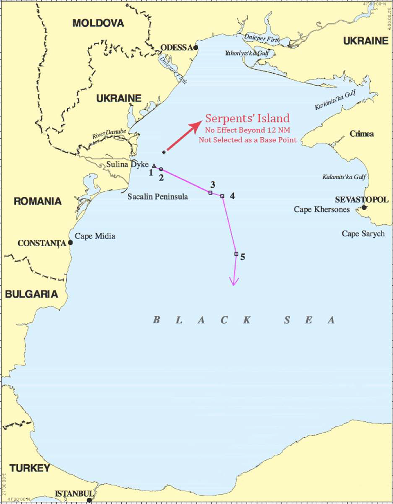
Figure 3 The final delimitation line, where Serpents’ Island was neither given any effect beyond twelve nautical miles (that is, beyond the territorial sea) nor selected as a base point (from Maritime Delimitation in the Black Sea (Romania v Ukraine), Judgment, [2009] ICJ Rep 61 at 133).
2012 bangladesh v myanmar

Figure 4 The parties’ initial claims. Myanmar claimed a strict equidistance line disregarding St. Martin’s Island (for both EEZ and continental shelf); Bangladesh asked for use of the angle-bisector method while giving full effect to St. Martin’s Island (from Delimitation of the Maritime Boundary in the Bay of Bengal (Bangladesh v Myanmar), Judgment, [2012] ITLOS Rep 4 at 75).

Figure 5 The final delimitation line, where St. Martin’s Island was neither given any effect beyond twelve nautical miles (that is, beyond the territorial sea) nor selected as a base point (from Delimitation of the Maritime Boundary in the Bay of Bengal (Bangladesh v Myanmar), Judgment, [2012] ITLOS Rep 4 at 129).
2012 nicaragua v colombia

Figure 6 Colombia’s initial claim based on a strict equidistance line where Quitasueño is selected as a base point (from Territorial and Maritime Dispute (Nicaragua v Colombia), Judgment, [2012] ICJ Rep 624 at 672).

Figure 7 The final delimitation line (from Territorial and Maritime Dispute (Nicaragua v Colombia), Judgment, [2012] ICJ Rep 624 at 714).
2014 peru v chile

Figure 8 The provisional equidistance line, which became the final delimitation line at the third stage (from Maritime Dispute (Peru v Chile), Judgment, [2014] ICJ Rep 3 at 68).
2014 bangladesh v india

Figure 9 The cut-off effect produced by the provisional equidistance line owing to the concavity (from In the Matter of the Bay of Bengal Maritime Boundary (Bangladesh v India), PCA Case no 2010-16 (2014) at 145).

Figure 10 A comparison of the final delimitation line and the provisional equidistance line (from In the Matter of the Bay of Bengal Maritime Boundary (Bangladesh v India), Judgment, PCA Case no 2010–16 (2014) at 159).
2017 ghana v côte d’ivoire

Figure 11 The difference between equidistance and angle-bisector lines (from Dispute Concerning Delimitation of the Maritime Boundary between Ghana and Côte d’Ivoire in the Atlantic Ocean (Ghana v Côte d’Ivoire), Counter-Memorial of Côte d’Ivoire, ITLOS Case no 23 (2016) at 162).

Figure 12 The cut-off effect produced by the provisional equidistance line owing to the concavity (from Dispute Concerning Delimitation of the Maritime Boundary between Ghana and Côte d’Ivoire in the Atlantic Ocean (Ghana v Côte d’Ivoire), Counter-Memorial of Côte d’Ivoire, ITLOS Case no 23 (2016) at 122).

Figure 13 The final delimitation line and the maritime areas allocated to the parties (from Dispute Concerning Delimitation of the Maritime Boundary between Ghana and Côte d’Ivoire in the Atlantic Ocean (Ghana v Côte d’Ivoire), Judgment, [2017] ITLOS Rep 4 at 146).
2017 croatia v slovenia

Figure 14 The parties’ claims and the provisional equidistance line (from Arbitration between the Republic of Croatia and the Republic of Slovenia (Croatia v Slovenia), PCA Case no 2012–04 (2017) at 317).

Figure 15 The coastal irregularity where the coastline of Croatia turns sharply southwards (from Arbitration between the Republic of Croatia and the Republic of Slovenia (Croatia v Slovenia), PCA Case no 2012–04 (2017) at 320).

Figure 16 The adjusted delimitation line for the territorial sea (from Arbitration between the Republic of Croatia and the Republic of Slovenia (Croatia v Slovenia), PCA Case no 2012–04 (2017) at 323).


