


Introduction
A new approach has been developed to reconstruct the architectural layouts of timber-framed and earthen-walled early Roman urban structures. Unlike masonry buildings with clearly defined walls, the interpretation of these structures can be particularly problematic (Fulford Reference Fulford and Fulford2012: 259). When reconstructing building plans, there has been a tendency to ‘fill in the gaps’ between earthen walls and post-holes (e.g. Frere Reference Frere1972: fig. 8; Perring Reference Perring, Schofield and Leech1987: fig. 65; Millett Reference Millett1990: fig. 40; Hill & Rowsome Reference Hill and Rowsome2011: fig. 181). Determining the internal layout of archaeological buildings requires the identification of residual superstructure components (evidence for which is often absent), internal floor surfaces (where they survive), hearths and the differentiation between internal and external areas (Carver Reference Carver, Schofield and Leech1987; Fulford Reference Fulford and Fulford2012: 258–60). The approach advocated here combines experimental archaeology and thin section micromorphology to provide more robust interpretations of roofed, unroofed and semi-open spaces, and for the locations of doorways. In order to understand fully the structural components and architectural evidence, it is important to classify occupation and accumulation deposits correctly during excavation. In addition, a clear understanding of formation processes enables reconstruction of dynamic chronologies of architecture and often repeated, diachronic use of structures (Carver Reference Carver, Schofield and Leech1987: 10; La Motta & Schiffer Reference La Motta, Schiffer and Allison1999; Fulford Reference Fulford and Fulford2012: 258). The ability to reconstruct the architectural layouts of early Roman urban structures is an important part of understanding the structuring of activities and the spatial organisation of households. In comparison with public buildings and villas, little work has been done on residential space within Romano-British towns (Millett Reference Millett, James and Millett2001: 64). In addition, to chart the planning of the earliest stages of Roman urban development, the precise measurements of individual buildings and properties are essential (Burnham et al. Reference Burnham, Collis, Dobinson, Haselgrove, Jones, James and Millett2001: 72–73). It is particularly important, therefore, to understand each stage in the development of domestic urban properties.
The extent to which building plans are retrieved in Romano-British archaeology is often limited by the spatial constraints of rescue excavation and by the bias of antiquarian excavation towards monumental buildings (Perring Reference Millett2002). In Britain, the nature of developer-funded rescue archaeology has placed inevitable constraints on the evaluation of spatial relationships within towns, as rescue archaeology tends to be more ‘keyhole’ in excavation strategy, with an emphasis on the depth of stratigraphy. Additionally, there is a tendency to report buildings in the form of a stratigraphic narrative, rather than in terms of their use of space (Fulford Reference Fulford and Fulford2012: 257). Frere's excavations at Verulamium between 1955 and 1961 marked the beginnings of open-area excavation (Fulford et al. Reference Fulford, Clarke and Eckardt2006: 7–8). They produced structures with significant depth and complexity, specifically a sequence of timber-framed, and later masonry, structures in Insula XIV (Frere Reference Frere1972).
Silchester (Hampshire, UK) is the site of the Roman regional centre or civitas capital of Calleva Atrebatum (Figure 1). Unlike the majority of Roman towns in Britain, which saw subsequent development from the medieval period up to the present, Silchester was abandoned and has remained a ‘greenfield’ site. It became the focus of antiquarian interest in the later nineteenth century when a sustained project (1890–1909) was initiated to recover the compete plan of a Roman town (Boon Reference Boon1974). Fortunately, these excavations were relatively superficial, allowing the possibility for modern archaeology with stratigraphic and geoarchaeological methodologies to explore the development and changing character of the town from Iron Age origins to post-Roman abandonment in much greater depth. With such objectives, the Silchester Town Life Project was initiated in 1997, focusing on a large area (3000m2) of Insula IX. The fieldwork was completed in 2014. While the mid and later Roman archaeology has now been published (Fulford et al. Reference Fulford, Clarke and Eckardt2006; Fulford & Clarke Reference Fulford and Clarke2011), work continues on the publication of the Iron Age and early Roman sequences (periods 0–2). The research presented here is mostly associated with the timber buildings (Figure 2) of the as yet unpublished period 2 (AD 70/80–125/50), but also of the period 3 (AD 125/50–200) occupation (Fulford & Clarke Reference Fulford and Clarke2011). It complements ongoing research on the geochemistry of the period 2 buildings (Cook et al. Reference Cook, Clarke, Fulford and Voss2014). These timber buildings have provideda unique opportunity to study the internal spatial and chronological relationships, and to compare the spatial and chronological relationships between buildings using a geoarchaeological approach (Banerjea Reference Banerjea, Fulford and Clarke2011; Cook Reference Cook, Fulford and Clarke2011).

Figure 1. Location of experimental sites (Butser Ancient Farm and St Fagans, UK, and Lejre, Denmark) and Roman Silchester.

Figure 2. Excavation plan of period 2 buildings, ERTB1, ERTB5 and ERTB8, Silchester (Fulford & Clarke Reference Fulford and Clarke2009); drawing by Margaret Mathews.
The integration of open-area excavation at Silchester, experimental archaeology from buildings at Butser Ancient Farm and St Fagans in the UK, and Lejre in Denmark (Figure 1), and micromorphology has enabled more robust interpretations to be made of architectural layouts of buildings at Roman Silchester. In some spaces at Silchester, archaeological features relating to super-structure were absent, and the nature of the roofs was unknown. Looking at the formation processes within the experimental hut floors using micromorphology (Banerjea et al. Reference Banerjea, Bell, Matthews and Brown2015) has helped to interpret the archaeological record at Roman Silchester.
Micromorphology is well established as a tool for interpreting archaeological site-formation processes. This technique has been widely applied to the investigation of the use of space within buildings (e.g. Matthews Reference Matthews, Barnham and Macphail1995; Matthews et al. Reference Matthews, French, Lawrence, Cutler and Jones1997; Shahack-Gross et al. Reference Shahack-Gross, Albert, Gilboa, Nagar-Hillman, Sharon and Weiner2005; Milek & French Reference Milek, French and Skre2007; Karkanas & Efstratiou Reference Karkanas and Efstratiou2009; Jones et al. Reference Jones, Challands, French, Card, Downes and Richards2010), as well as external spaces and middening practices (Simpson & Barrett Reference Simpson and Barrett1996; Shillito & Matthews Reference Shillito and Matthews2013; Shillito & Ryan Reference Shillito and Ryan2013). The application of micromorphology to Roman urban archaeology has, up to now, been largelylimited to the study of dark earths to determine their formation processes and to identify traces of past activities (e.g. Macphail Reference Macphail, Hall and Kenward1994; Macphail et al. Reference Macphail, Galinie and Verhaeghe2003a). This study aims to inform the architectural interpretation of urban spaces that may have been trampled, damp, open or partially open and, as a result, susceptible to and affected by weathering, erosion and disturbance. It is therefore important to understand processes such as trampling (Gé et al. Reference Gé, Courty, Matthews, Wattez, Goldberg, Nash and Petraglia1993), clay translocation and coatings (Courty et al. Reference Courty, Goldberg and Macphail1989; French Reference French2003: 123, 156; Goldberg & Macphail Reference Goldberg and Macphail2006: 356–58), the formation of new minerals as a result of diagenesis and decay of inclusions such as ash, bone and dung (Weiner Reference Weiner2010), and mesofaunal bioturbation (Macphail Reference Macphail, Hall and Kenward1994; Canti Reference Canti2003, Reference Canti2007).Experimental archaeology can play an important role in advancing archaeological interpretations through creating a database of reference material from known activity areas and modern analogues. These data can be used to provide more robust interpretations of the archaeological record (Goldberg & Macphail Reference Goldberg and Macphail2006: 247–48; Macphail & Linderholm Reference Macphail, Linderholm, Hill and Rowsome2011: 461; Banerjea et al. Reference Banerjea, Bell, Matthews and Brown2015), in a similar way as when applied to ethnoarchaeological research (Matthews et al. Reference Matthews, Hastorf, Begums and Hodder2000; Villagran et al. Reference Villagran, Balbo, Madella, Vila and Estevez2011; Milek Reference Milek2012). Geoarchaeology is a pathway of research that has brought together ethnoarchaeology and experimental archaeology to interpret site-formation processes and to understand the formation of refuse assemblages, in order to identify the use of space and the structuring of activities within households. It is necessary, however, for experimental research to have clear research designs and scientific rationales (Bell Reference Bell, Allen, Sharples and O’Connor2009) to feed back into the process of interpreting the archaeological record, to provide the facility for the physical testing of hypotheses and also to suggest new systems of data recovery and recording (Reynolds Reference Reynolds1979: 83). Pedological and sedimentological investigations were generally not considered at the inception of many experimental archaeology sites (Crowther et al. Reference Crowther, Macphail and Cruise1996: 114). Despite this, when applied to an experimental context, micromorphology has identified the mechanisms and pathways by which materials are transported in occupation contexts (Banerjea et al. Reference Banerjea, Bell, Matthews and Brown2015): activity areas such as animal husbandry (Macphail et al. Reference Macphail, Cruise, Allen, Linderholm and Reynolds2004; Canti et al. Reference Canti, Carter, Davidson and Limbrey2006; Macphail et al. Reference Macphail, Cruise, Allen and Linderholm2006; Macphail & Crowther Reference Macphail and Crowther2011; Banerjea et al. Reference Banerjea, Bell, Matthews and Brown2015); short-term changes to soils and sediments (Crowther et al. Reference Crowther, Macphail and Cruise1996; Macphail et al. Reference Macphail, Crowther, Acott, Bell and Cruise2003b); and post-depositional alterations to occupation deposits (Banerjea et al. Reference Banerjea, Bell, Matthews and Brown2015).
Field methodology
Most of the experimental buildings investigated in this research were constructed 16 years prior to sampling and have housed a range of activity spaces over their lifetime. Micromorphological examination of structures at Butser, St Fagans and Lejre has enabled formation processes within buildings to be studied in a temperate climate in different geological settings, providing examples that inform the investigation and interpretation of activity traces in a range of archaeological settlement contexts on several substrates. These experimental archaeological contexts enabled targeted examination, at a high chronological resolution, of known activity areas, specific depositional processes and taphonomy within structures at the microstratigraphic scale. Specific processes such as dumping, trampling, decay and collapse were readily observed in the experimental buildings (Banerjea et al. Reference Banerjea, Bell, Matthews and Brown2015). For the experimental data to be applicable to spatial investigations of archaeological urban and settlement sites, samples were collected for micromorphological analysis from key locations within the experimental buildings at Butser, St Fagans and Lejre (Banerjea et al. Reference Banerjea, Bell, Matthews and Brown2015): from roofed, unroofed and semi-open spaces; from damp areas within buildings; and from doorways.
The Insula IX excavation at Silchester enabled micromorphology samples to be collected spatially across several early (ERTBs 1–8) to mid-Roman (MRTB1) timber buildings dating from periods 2–3 (Figures 3, 4 & 5). Despite the opportunities for extensive spatial examination of structures, open-area excavation still encounters problems with the truncation of stratigraphy by features such as the foundations of later buildings and, at Silchester, trenches from Antiquarian excavations (Fulford & Clarke Reference Fulford and Clarke2002). Yet the truncations made through timber-framed structures have provided windows into the stratigraphy and section-faces from which micromorphology samples have been collected. The coordinates (x, y, z) for each micromorphology sample, with the exception of two samples from MRTB1, were recorded, in order to locate each sample on the site grid plan for the excavation of Insula IX, Silchester. Samples from MRTB1 were recorded to a specific 5 × 5m grid square. Sampling was targeted to collect levelling deposits, the earthen and mortar floors of buildings, and occupation deposits. The archaeological structures featured in this research (Figure 2) are all similar in shape and overall design: square or rectangular with central hearths. Experimental structures at Lejre were also square or rectangular with central hearths, and structures at Butser and St Fagans were circular with central hearths. At Silchester, where building form diverges from the regular shape, for example, the additions to ERTB1 and ERTB8, the irregular shape was probably because they respected the main road that was in proximity and were shaped to fit around it.

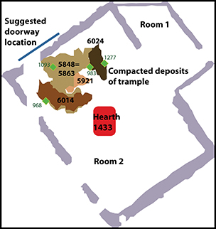
Figure 3. The location of trampled sediment and the suggested location of the doorway within building ERTB1; the superimposed trample deposits show the location of the doorway through time within this multi-phase structure; the truncation of the beam-slots (grey) is a result of Victorian excavation trenches; sample locations are marked in green.

Figure 4. The structural modifications of building ERTB8: a) the initial layout of the earthen walls (grey) and hearth (8154); b) the earliest deposit of trample within the doorway at a point of structural modification; c) the later deposit of trample and the new doorway location. Truncations to the earthen walls are a result of excavation trenches that were created by Victorian excavators, and cuts by the foundation trenches of later Roman structures; sample locations are marked in green.

Figure 5. Plan of building MRTB 1 (top left): the square box shows a 5 × 5m grid square where samples 767 and 768 (top right) were collected from the deposit of compacted trample; note the beam-slots (grey) of the underlying structure, building ERTB1 (Figure 3). Microlaminated silty clay coatings (a & b) are evidence of repeated weathering episodes within trample deposits in this area. Trample deposits in samples 767 and 768 (top right) comprise super-imposed micro-lenses of hearth debris, including heat-fractured flints, minerogenic sediment, herbivore dung (c and d) and vivianite (e & f). These micro-lenses were not identified during excavation and were thought to be a single deposit that was originally interpreted as a floor surface; the location of sample 666.3 is marked in green.
Laboratory methodology
Micromorphology samples (from Roman Silchester and all of the experimental sites) were prepared in the Microanalysis Unit at the University of Reading. The procedure followed is the standard protocol for thin-section preparation (Murphy Reference Murphy1986). Samples were oven-dried at 40°C, and then impregnated with epoxy resin while under vacuum. Slides were prepared to the standard geological thickness of 30μm.
Micromorphological investigation was carried out using a Leica DMLP polarising microscope at magnifications of ×40–400 under plane polarised light (PPL), crossed polarised light (XPL), and oblique incident light (OIL). Thin-section description was conducted using the identification and quantification criteria set out by Bullock et al. (Reference Bullock, Fedoroff, Jongerius, Stoops and Tursina1985) and Stoops (Reference Stoops2003), with reference to Courty et al. (Reference Courty, Goldberg and Macphail1989). Photomicrographs were taken using a Leica camera attached to the Leica DMLP microscope.
Results and discussion
Micromorphological characteristics attributed to both trampling as a formation process and as a post-depositional alteration have been identified in experimental and archaeological sediments at these temperate sites (Table 1). In order for compacted trample deposits to form, experimental archaeological research has demonstrated that damp environmental conditions must be present. Building collapse or the partial removal of roofs also played an integral role in the formation of internal deposits of compacted trample (Banerjea et al. Reference Banerjea, Bell, Matthews and Brown2015). The locations of trampled sediment in archaeological buildings have been used to identify wet areas of buildings such as doorways (Figures 3 & 4) or semi-open spaces (Figure 5) in the archaeological buildings at Roman Silchester; differentiation between the two may be determined by the type of clay coatings.
Table 1. Post-depositional alterations within experimental (E) and archaeological deposits (A) of trampled sediment.

Key for frequency: ●●●●● = >20%; ●●●● = 10–20%; ●●● = 5–10%; ●● = 2–5%; ● = <2%
Identifying doorways
The nature of the urban archaeological record in Britain makes it difficult to identify doorways from excavated field evidence alone; full plans may not be present or walls may not survive to sufficient height (Perring Reference Perring, Schofield and Leech1987; Perring Reference Millett2002). Porched entrances in Iron Age houses make doorways easier to identify (Cunliffe Reference Cunliffe1978; Perring Reference Millett2002). In addition, doorways may be particularly difficult to identify from trace archaeology. When dealing with timber-framed buildings, faint linear colour distinctions left by sill-beams may be all that remain of a particular structure (Carver Reference Carver, Schofield and Leech1987).
At Wroxeter, as part of excavations of the Macellum and Roman Baths, Ellis suggested that the ‘trampled clay’ area between rooms 5 and 8 in building 3 may have marked the doorway (Ellis Reference Ellis2000: 14). Observations from the Butser, St Fagans and Lejre experimental sites support Ellis's suggestion, showing that in temperate regions, internal doorways can be wet, trampled areas (Banerjea et al. Reference Banerjea, Bell, Matthews and Brown2015). In experimental archaeology, compacted trample deposits have been observed to form in doorways and semi-open spaces (Banerjea et al. Reference Banerjea, Bell, Matthews and Brown2015). Doorways are also catchment areas for sediment from both outside and inside the buildings, as observed in the semi-arid site of Saar, Bahrain (Matthews & French Reference Matthews, French, Killick and Moon2005). At Lejre, ‘pitting’ in the surface topography of the floor of building 1 (Iron Age village) is reported to have been caused by several factors: rain erosion, human and animal trampling, and abrasion by sweeping (Banerjea et al. Reference Banerjea, Bell, Matthews and Brown2015). In experimental and archaeological buildings, potential indicators of doorways from sediments at temperate sites include compacted trample deposits or mixed trample and accumulation deposits (Table 1), and post-depositional features such as dusty impure or silty clay coatings, which may be microlaminated if the area is repeatedly rained on heavily; for example, a semi-open space. These indicators co-occur archaeologically in ERTB1, ERTB8 and MRTB1, and show features of weathering and decay processes such as neomineral formations and organic staining (Table 1). The clearest evidence for the identification of a doorway is within ERTB1. Successive layers of trample built up in one specific part of ERTB1 (Figure 3), and the presence of dusty impure clay coatings suggested that this area of the building was damp. Silty clay coatings that are poorly sorted, have a weak organisation, diffuse extinction and an absence of lamination are also termed dusty impure clay coatings, and are indicative of turbulent hydraulic conditions (Courty et al. Reference Courty, Goldberg and Macphail1989). On an archaeological settlement, the presence of dusty impure clay coatings can indicate anthropogenic disturbance processes such as trampling and dumping (Goldberg & Macphail Reference Goldberg and Macphail2006).
ERTB8 also contains compacted trample layers with dusty impure clay coatings and presents another case study for defining doorways in archaeological buildings (Figure 4). Post-excavation work on the phasing and stratigraphy for ERTB8 is not yet completed. Micromorphology has, however, identified units of compacted trample (Table 1), which inform the interpretation of this dynamic and evolving building. It is probable that the earliest trample unit, context 16652, which overlies hearth 8154 (Figure 4a & b), formed once the hearth fell out of use and this room became an access route into the building. Later, this access route fell out of use and was covered with gravel levelling, perhaps to form a yard and the doorway to the building was moved to the edge of the later compacted trample unit, context 6265 (Figure 4c).
Identifying semi-open spaces
Partially roofed or walled spaces in a temperate urban archaeological site can be identified by the presence of clay translocation, particularly microlaminated clay coatings, within units of compacted trample and discard deposit types, and deposition of wind- or water-sorted sediment. As the fields overlying the Roman town of Silchester were previously used as arable land until 1979, it is important to consider that translocated clays may post-date a site by many hundreds or thousands of years, relating to processes such as land clearance, disturbance by ploughing and a fluctuating water table (French Reference French2003; Goldberg & Macphail Reference Goldberg and Macphail2006). Examination of the distribution of clay coatings, and study of their formation using experimental archaeology, has, however, enabled microlaminated silty clay coatings to be identified in very specific locations within buildings (Table 1; Figure 5); for example, in MRTB1 at Silchester they occur within the deposits of compacted trample and a discard deposit associated with the abandonment of the structure, but not within the constructed earthen floor surface (sample 666.3) inside the building (Figure 5). The analysis of deposits within the experimental buildings has shown that silty clay particles were mobilised due to very localised redox conditions, associated with the decay of organic matter, and occurred with deposits of trampled material during or at the end of the use of particular areas and buildings; for example, after roof removal (Banerjea et al. Reference Banerjea, Bell, Matthews and Brown2015).
The evidence for microlaminated silty clay coatings may indicate that ERTB1, room 1, ERTB8 and MRTB1 had wetter conditions (Table 1). In MRTB1, the microlaminated clay coatings are localised within compacted trampled layers (Figure 5a & b), suggesting that this space was partially roofed or without walls (given the absence of super-structural components), perhaps a shelter, which was a multi-functional space with a hearth and where livestock (herbivores) were kept. Compacted trample deposits are characterised by parallel orientation of soft materials such as plant remains and dung (Figure 5c & d), implying that downward compression aligned these malleable inclusions parallel with the surface of the context below (Banerjea et al. Reference Banerjea, Bell, Matthews and Brown2015). Harder materials such as rock fragments, minerals and metallurgical residues are unoriented (not aligned to any other specific features within deposits), randomly distributed and do not share orientation with any other components (Banerjea et al. Reference Banerjea, Bell, Matthews and Brown2015). The deposit of ‘clods’ of sediment from the soles of feet formed lenses of sediment when compressed during deposition on comparatively dry surfaces in roofed spaces. Had the area been completely unroofed it is unlikely that the compacted material would have built up in layers but rather would have been churned into one homogeneous unit, as has been observed at semi-arid sites (Matthews Reference Matthews, Barnham and Macphail1995); failing roofs can radically transform occupation deposits within buildings and eventually lead to soil development, which may resemble a ‘dark earth’, as observed on a temperate experimental site at Lejre (Banerjea et al. Reference Banerjea, Bell, Matthews and Brown2015). The effects of failing roofs could have significant implications for the identification of structures in the archaeological record at temperate sites in terms of the survival of evidence.
In ERTB8, the microlaminated silty clay coatings occur within hearth rake-out deposits and in situ hearth ashes from hearth 8102/5690, and in ERTB1 they occur within accumulation deposits, trampled sediment and in situ ashes around hearth 1433 (Figures 3 & 4). In both ERTB1 and ERTB8, this may suggest that activities focused on the hearths, involving trampling around the hearth, the use and spillage of water, and fluctuating redox conditions from decaying organic materials (fuel and food residues), could be the mobilising factors of clay translocation in these units. Experimental research has demonstrated that chemical alterations can also play a key role in the formation of silty clay coatings, where the processes that cause the fluctuations in redox conditions appear to have arisen from chemical changes relating to the decay of organic matter and dung, and the replacement of organics with iron and manganese (Banerjea et al. Reference Banerjea, Bell, Matthews and Brown2015).
Conclusion
Used in conjunction, experimental archaeology and micromorphology have integral roles to play in characterising archaeological deposits and interpreting urban site-formation processes. The comparative analysis of micromorphology from experimental buildings and from Romano-British structures at Silchester has informed the interpretation of their architectural layout. This research has enabled the mapping of dynamic structural modifications and the changing use of urban space through the identification and changing locations of trampled sediment, which reveals changes in the way people moved through structures. In a temperate environment, for successive layers of trampled sediment to build up, it is necessary for conditions within a structure to be damp but not fully open to rain, as this would cause churning of the deposits. The co-occurrence of dusty impure clay coatings and deposits of compacted trample has been linked to the location of doorways, particularly as these deposits have built up, superimposed in a specific location. It has been possible to differentiate between roofed spaces, such as doorways, and those that were semi-open (partially roofed or partially walled), and may have served as shelters, particularly for livestock. Microlaminated silty clay coatings within deposits of trampled sediment within semi-open structures indicated wetter conditions. Identification of the specific micromorphological attributes within trampled sediments can contribute to the interpretation of specific spaces, particularly in locating doorways and in tracing structural modifications within other multi-period urban archaeological sites, and indeed in a variety of settlements with timber-framed or earthen structures.
Acknowledgements
The authors would like to acknowledge the Arts and Humanities Research Council for funding Rowena Banerjea's doctoral research; Lejre Historical and Archaeological Research Centre for grant HAF21/07; the School of Archaeology, Geography and Environmental Science, University of Reading, for funding the ‘Life-Histories of Buildings and Site Formation Processes’ research project; and the National Museum of Wales for funding the excavation and sampling of the Moel-y-Gaer roundhouse at St Fagans. In addition, the authors would like to thank the staff involved with the Town Life Project at the Silchester excavations, the University of Reading, and at Butser, Lejre and St Fagans; and all fieldwork team-members for their assistance and contributions. Particular thanks go to Christine Shaw, Marianne Rasmussen, Ken Brassil, Adam Gwilt, Ian Daniels, Nina Helt-Nielsen, Rob Hosfield, Stephen Nortcliff, Jennifer Foster, Amy Poole and Christopher Speed. Banerjea would further like to thank Charly French and Hella Eckardt for their helpful comments relating to her doctoral thesis. The authors also wish to thank Will Bowden and the anonymous reviewer for their comments, which made this a clearer and more focused paper.


