


Introduction
Terra Culmensis (Kulmerland, or Chełmno Land) is a historical region in northern Poland, located to the east of the Lower Vistula Valley (Kondracki Reference Kondracki1998) (Figure 1). In the AD 1220s, the Polish prince Konrad of Mazovia ordered missionary action in this region, targeting the neighbouring pagan Prussian tribes. This missionary work was initially headed by the Bishop of Prussia, Christian of Oliva. But retaliatory raids by the Prussian tribes led to the Knights of the Teutonic Order being invited to this borderland in 1226 and, two years later, the Mazovian prince granted them a lease on Chełmno Land. Until recently, it was assumed that the Teutonic Order's presence in this region was originally decreed in the Golden Bull of 1226 by the German emperor Frederick II, who confirmed the bequest of Chełmno Land to them by Konrad of Mazovia. It is, however, now thought that this document was issued in 1235 (Jasiński Reference Jasiński1994).

Figure 1. Castles of the medieval Teutonic Knights in Chełmno Land (figure by P. Molewski).
The military successes of the Teutonic Knights were undoubtedly influenced by their crusader ideology (Pluskowski Reference Pluskowski2013). Until the 1280s, they were engaged in crusading campaigns against the Prussian tribes and gradually occupying the latter's lands. In 2016, the Institute of Archaeology at Nicolaus Copernicus University in Toruń initiated a project with the aim of recreating the history of defensive settlements in the earliest-settled, western part of the State of the Teutonic Order. It had long been assumed that a small headland on the edge of the slope overlooking the Lower Vistula Valley at Unisław was the location of a stone castle built by the Teutonic Knights at the end of the thirteenth century (Figure 2). Its general location was identified using historical cartography, records from the late eighteenth and early nineteenth centuries, and information from local residents. The discoveries made at Unisław not only reveal the form and layout of a previously unknown timber-and-earth stronghold and those of the stone building erected in its place, they also illuminate the history of the development of the Teutonic Order's military architecture.
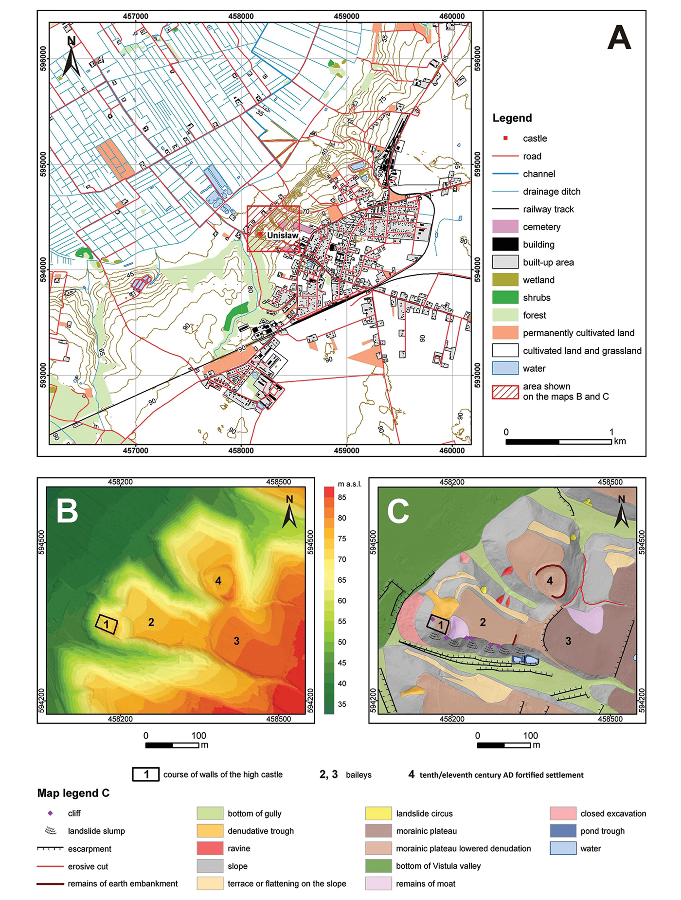
Figure 2. Location of the Unisław castle site: A) topographic map; B) hypsometric map; C) geomorphological map (figure by P. Molewski).
Castle location and history
Prior to the recent investigations, the stone castle at Unisław was little understood. Neither its layout nor the precise chronology of the construction of the so-called high (or upper) castle were known. The castle remains are situated in the west of Chełmno Land, on the outskirts of the modern village (Figure 2A–C). The castle baileys (or outer wards) were located within the headland and to the east of the high castle. The remains of a tenth- to eleventh-century fortified settlement are located to the north-east. This castle was created in connection with fundamental changes that took place in the Teutonic Order's State in the late 1270s and early 1280s, when the Teutonic Knights completed their conquest of pagan Prussian tribal lands (Jóźwiak Reference Jóźwiak1997). The earliest mention of the Unisław commandry appears in a document issued on 31 May 1285 (Voelky Reference Voelky1885–1887), but an administrative district associated with the castle was probably created just after 1278 (Guerquin Reference Guerquin1984; Jóźwiak Reference Jóźwiak1997).
Methods
Archaeological and architectural investigations at the Unisław castle site were preceded in 2016 by aerial and geophysical surveys, and were supplemented by palaeoenvironmental studies and radiocarbon dating. Non-invasive techniques included the use of aerial documentation to produce digital surface and terrain models. The most important element of the preliminary work was the extensive use of magnetic and electrical resistivity surveys. Magnetic measurements were taken using a caesium magnetometer (Geometrics 858-G) with two sensors set in a horizontal configuration at a distance of 1m. The magnitude of the total vector of the magnetic field was recorded in north–south sweeps, with the sensors 1m apart along the east–west axis. Each successive sweep was performed parallel to the previous one at an interval of 0.1m. (David et al. Reference David, Linford and Linford2008). The magnetic geophysical survey covered an area of 0.23ha within the high castle. The electrical resistivity (ADA-07 ELMES) survey was carried out using a 1m grid referenced to the geodetic grid established for the magnetic survey. The results of the aerial and geophysical surveys were used to identify suitable locations for subsequent excavation. Clear anomalies indicating the structural outline of the high castle were targeted for excavation with six trenches in 2017.
Prior to excavation, geographical and geomorphological investigations included a physiographical description of the castle location and its surroundings, and a reconstruction of the original topography. Both analyses used digital and analogue geospatial data, as well as geological maps (Kozłowska & Kozłowski Reference Kozłowska and Kozłowski1988, Reference Kozłowska and Kozłowski1990). Topographical changes in the high castle site identified in the archaeological studies were cross-referenced with historical maps. The georectification of these maps and the integration of all the geospatial data were performed using GIS.
Archaeobotanical analysis focused on four samples collected from: the oldest cultural context (eleventh–twelfth centuries; trench 2) from the entire site; the courtyard (thirteenth century; trench 3); the kitchen (fourteenth century; trench 3); and near the hypocaust (both thirteenth/fourteenth centuries; trench 5). All samples were weighed and floated by running water through two 0.5 and 0.2mm mesh sieves. Carpological identification was undertaken using comparative specimens from the collection of the Laboratory of Palaeoecology and Archaeobotany at Gdańsk University (taxonomic names after Mirek et al. Reference Mirek, Piękoś-Mirkowa, Zając and Zając2002). Four charcoal samples from trenches 1 and 2 were submitted to the Poznań Radiocarbon Laboratory for AMS radiocarbon dating.
The excavations also yielded numerous animal bone fragments. Two bone assemblages from the commandry (1280s) and procuratorship (c. 1320–1450) periods—dated by analysis of historical sources, pottery fragments and stratigraphic context—were analysed using comparative mammal, bird and fish specimens in the Laboratory of Natural Environment Reconstruction at Nicolaus Copernicus University. The identification of species diversity, anatomical structure, age, sex and butchery patterns followed standard zooarchaeological methods (Reitz & Wing Reference Reitz and Wing1999).
Results
The anomalies detected by the geophysical survey of the high castle site were assumed to indicate the thermoremanent magnetisation of subsurface brick structures. To investigate this assumption, six trenches were localised on anomalies. The surface topography model was prepared using the real time kinematic altitude measurements, before being combined with the magnetometry data. By combining the magnetometry data with the surface topography, we were able to locate and interpret the buried castle structures, and establish the spatial relationship between the high castle and the nearest bailey (Figure 3A).
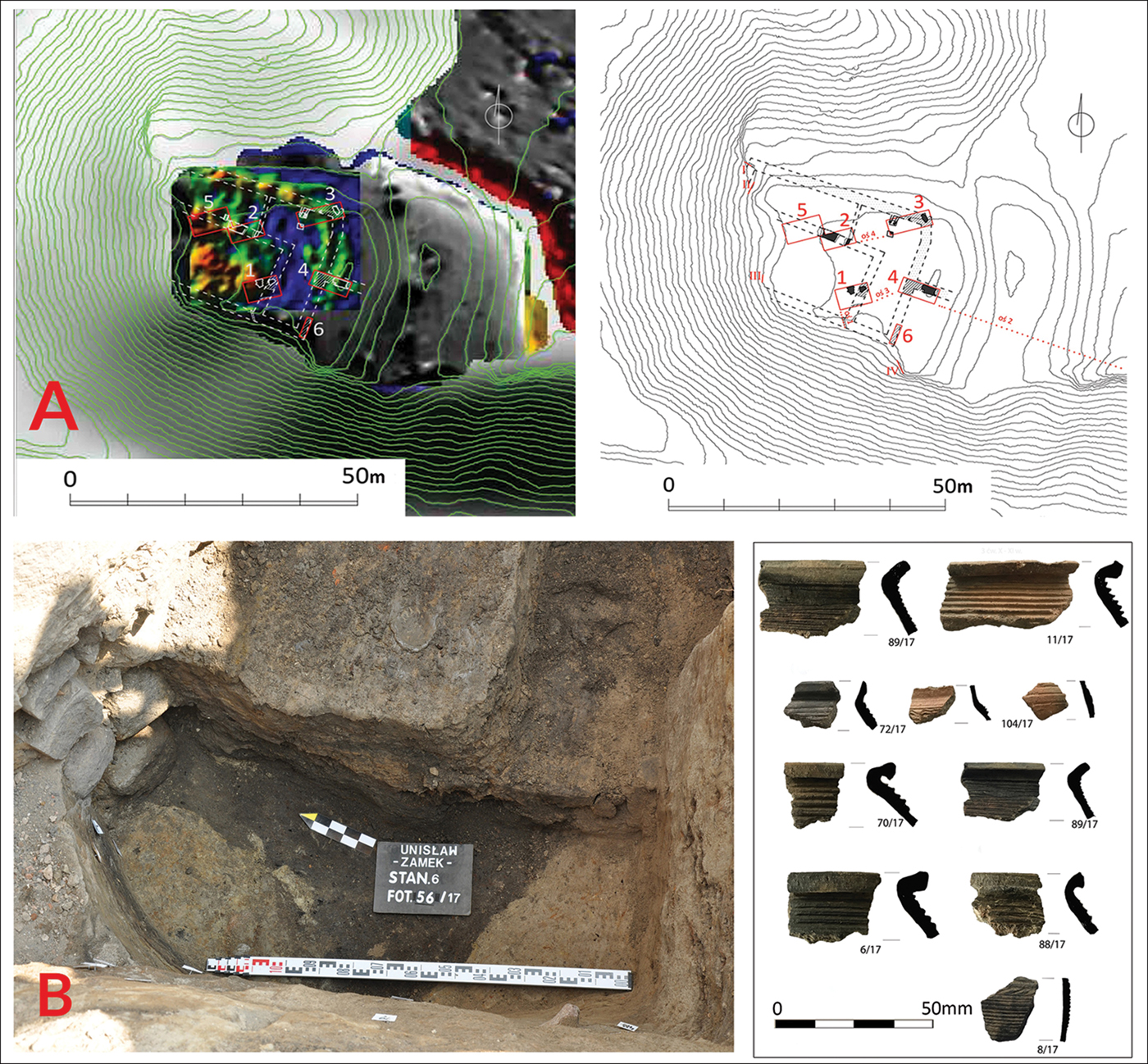
Figure 3. Results of geophysical studies: A), with the location of excavation trenches on the high castle (top right) at Unisław; B) oldest settlement layer, with recovered ninth- to eleventh-century potsherds (bottom right) (figure by K. Misiewicz, W. Małkowski, M. Wiewióra & B. Wasik).
The oldest occupation layer at the site was recorded in trench 2 (Figure 3B) and comprised a 0.4–0.5m-thick black, clayey humus. It contained sherds of pottery (so-called ‘traditional ceramic’) dated to the eleventh century—a period when the early medieval settlement adjacent to the castle was in decline. The headland on which the later masonry castle was built was briefly abandoned in the twelfth century, as indicated by the lack of ceramic evidence from that period.
The most significant evidence for the oldest phases (1380s) of Teutonic settlement in Unisław came from trenches 1, 2 and 5. The western and southern parts of trench 1, for example, yielded the remains of an earthen rampart (Figure 4A), which had been reinforced with stone cladding on the internal side. The rampart was constructed of thin layers of clay, sand and burnt matter and, most importantly, broken bricks. The latest stratigraphy associated with the later thirteenth-century timber-and-earth Teutonic Order stronghold was recorded in trench 2. The presence of a metallurgical workshop is suggested by the discovery of partially melted metal objects, iron slag and semi-finished crossbow bolt heads (Figure 4B) in trench 2, in direct association with the stronghold. In trench 5, a small chamber from a hypocaust furnace was also discovered (Figure 4C). The final occupation stage (c. 1320) of the timber-and-earth stronghold is represented by the presence of ‘grey ceramics’ in all trenches, which are typical of settlements associated with Teutonic Knights (Kruppé Reference Kruppé1981).
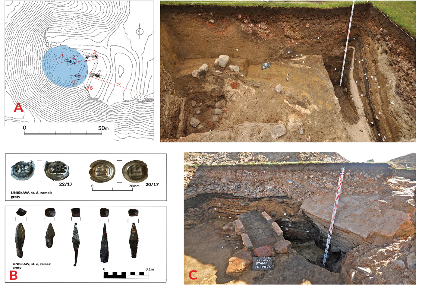
Figure 4. Rampart remains and extent of the Teutonic Order's stronghold from the 1280s (A–B); C) fourteenth-century Teutonic Order coins and crossbow bolt heads; D) remains of the hypocaust furnace (figure by B. Wasik & M. Wiewióra).
Each of the six trenches revealed the remains of the mid fourteenth-century stone castle erected on the site of the previous stronghold. The four sides of the high castle measured approximately 35 × 23 × 37 × 26m. The main building, measuring around 16 × 30m, occupied the south-western part of the mid fourteenth-century stone castle (Figure 5A–B). The proportions of the main building's layout indicate that it was a ‘tower house’ (Festes Haus) that lacked a cellar. Tenement houses, which represent the second-most frequently encountered type of castle house in Poland, always have oblong layouts. Tower houses, however, have a more compact, rectangular form and greater width; they often functioned as offices for lower-ranked Teutonic officials (Poliński Reference Poliński2003, Reference Poliński2013). Such features were exhibited by the main building at Unisław. Its walls, around 1.7m thick, were built on arcaded foundations—a method used for construction on unstable substrates (Kąsinowski Reference Kąsinowski1970). The storeys above the first floor were, therefore, probably timber-framed. To the north and east, the tower house was protected by a defensive wall that was also constructed on arcaded foundations. To ensure the structure's stability, the tower house and defensive wall were surrounded by a 6m-wide earthen terrace. The service areas of the building were concentrated in the north-eastern corner, where the remains of a castle kitchen—comprising a furnace and pantry—were discovered. The entrance to the castle was situated on the eastern side of the building; access was via a bridge across a moat.

Figure 5. A) Reconstruction of the tower house from the mid fourteenth century; B) horizontal projection of two phases of the building—fourteenth and fifteenth centuries (figure by B. Wasik & P. Moszczyński).
Two baileys adjoined the castle (Figure 6A). The inner bailey—bailey 1—is trapezoidal in shape, measuring approximately 120 × 90 × 50m and covering an area of around 0.7ha (Figure 6B). Bailey 2, to the east of bailey 1, and measuring approximately 80 × 115m, covers approximately 0.8ha (Figure 6). The reconstructed plan of the tower house and defensive walls shows that the north-west wing and part of the south-west wing extended beyond the present-day edge of the plateau of the headland (Figure 6A–B). Molewski et al. (Reference Molewski, Wasik and Wiewióra2018) have demonstrated that subsequent sand and gravel quarrying have caused landslides, which have destroyed parts of the headland slopes.
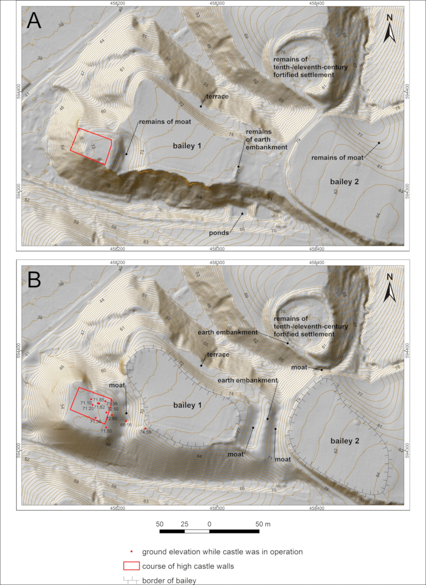
Figure 6. Attempted reconstruction of the topography of the castle: A) digital elevation model of the present-day surface; B) digital elevation model of the reconstructed surface (figure by P. Molewski).
Only sparse archaeobotanical remains were recovered during the excavations. These were identified only in the samples taken from the kitchen (trench 3) and around the hypocaust furnace (trench 5). The sample from the kitchen room yielded charred millet grains (Panicum miliaceum) (Figure 7IA), charred pea seeds (Pisum sativum) (Figure 7IB–C) and indeterminate cereal remains. These all represent cultivated plants, some of which were core elements of the daily diet in the Middle Ages. Millet, for example, was used mainly for groats (Strzelczyk Reference Strzelczyk2003). At Unisław, charred millet grains were preserved alongside fragments of millet hull, possibly indicating that unprocessed cereal was transported to the castle. Pea may have been consumed either raw or after processing, served as a main dish or alongside other foods (Dembińska Reference Dembińska, Hensel and Pazdura1978). The survival of millet and pea remains may be due to accidental burning during food preparation. The kitchen sample also contained the charred remains of common arable weeds. These include false cleavers (Galium spurium, Figure 7ID–E), field gromwell (Lithospermum arvense, Figure 7IF) and black-bindweed (Fallopia convolvulus, Figure 7IG). These weeds probably grew among the cereal crops and were brought to the castle with the latter. The charred fruits of curlytop knotweed (Polygonum lapathifolium, Figure 7IH) and goosefoot (Chenopodium album) represent evidence for ruderal plant communities that may have grown near the castle, or accompanied the root crops. Material collected near the hypocaust contained sparse plant remains, and these were not part of waste food deposits.

Figure 7. I) Plant remains: A) charred grain of Panicum miliaceum); B–C) charred seeds of Pisum sativum); D–E) charred fruit of Galium spurium, ventral (D) and dorsal (E) side; F) mineralised fruit of Lithospermum arvense; G) charred fruit of Fallopia convolvulus; H) charred fruit of Polygonum lapathifolium. II) The composition of animal taxa and percentage representation of their remains in the two occupation phases of the castle (figure by M. Badura, K. Maciejewska, D. Makowiecki & M. Wiewióra).
The number of identified specimens (NISP) of animal bone from both Teutonic occupation phases is very similar (Figure 7II). The taxa recorded are mostly of economic significance, with the largest represented by domestic mammals (pig, cattle, sheep/goat). Game species played a minor role in the diet. It is important to emphasise the presence of European hare and roe deer. Based on previous studies of the early medieval centres in Greater Poland and Chełmno Land (Makowiecki Reference Makowiecki2003), it is possible to suggest that both species thrived locally due to the agricultural landscape surrounding the castle at Unisław. The diet of the castle's residents in the Teutonic period can be described as being varied but stable. In both phases, food obtained from livestock predominated in terms of the meat component of the diet, the most important being pork, followed by beef and mutton/goat meat. Birds—predominantly domestic chicken—were also eaten, as were fish, both local species and sturgeon, the latter caught during their spring migration up the Vistula to their spawning grounds. In addition, cod and herring were imported from coastal towns. Scarce synanthropic vertebrate (e.g. rat, dormouse, bat) remains were also recorded.
Chronology
Two distinct groups of material, typical of the Slavonic and Teutonic settlement periods at Unisław, dominate the overall cultural assemblage. The oldest group is represented by fragments of ‘traditional’ vessels, recovered from trench 2 from both the ninth- to eleventh-century cultural layer, and from the secondary depositional material. The most abundant group, however, comprises fragments of ‘grey’ vessels. These are unambiguously associated with the first Teutonic Knights who arrived in the 1280s. The most recent pottery fragments, dating to the mid fifteenth century, come from layers associated with the destruction of the castle, during the Thirteen Years War between the Teutonic Order and Poland (1454–1466).
The earliest AMS determinations are from the rampart and date to 879–1013 and 775–973; one sample from trench 2 is dated 1039–1220. The latest dates come from trench 2, ranging from 1287–1399 (Table 1).
Table 1. Radiocarbon dates for Unisław (OxCal v4.2.3, Bronk Ramsey & Lee Reference Bronk Ramsey and Lee2013); r:5 IntCal13 atmospheric curve (Reimer et al. Reference Reimer2013); Poznań Radiocarbon Laboratory.

Discussion
The investigations at Unisław provide valuable new information concerning the history of castles and the presence of the Teutonic Knights in the Polish-Prussian borderlands. The Knights of the Teutonic Order arrived in Chełmno Land in 1230, where they either received or built their first strongholds (Poliński Reference Poliński2003, Reference Poliński2006; Dygo Reference Dygo, Kubicka and Kwiatkowski2008). The lands issued to them were administratively united with their extensive properties in Bohemia and Moravia, and from 1237, in Livonia (Jóźwiak Reference Jóźwiak2001). In subsequent years, the Knights subjugated new areas of pagan Prussia, reinforcing their power through the construction of numerous timber-and-earth strongholds and the first towns in the region (Czaja Reference Czaja and Nowak2000; Wasik Reference Wasik2016a). These strongholds were not simply a continuation of local early medieval fortresses, as they had other functions related to the implementation of colonisation and a new social system (Pluskowski et al. Reference Pluskowski, Boas and Gerrard2011a & Reference Pluskowski, Brown, Shillito, Seetah, Makowiecki, Jarzebowski, Klavins and Kreemb). The strongholds were founded either on older—often damaged or abandoned—castles, or in new, previously unoccupied locations. They were also protected by ramparts. Historical sources indicate that the earliest timber-and-earth strongholds also featured, among other facilities, chapels, kitchens, refectories and towers.
Defeats experienced by the Teutonic Knights during the Prussian uprising of the 1240s demonstrate the ineffectiveness of these strongholds, which, in most cases, had been plundered and acquired by the Prussians (Wenta Reference Wenta2003). These defeats prompted the construction of new stone strongholds (Figure 8A–B) (Wasik Reference Wasik2016b). Initially structures of irregular size and shape (e.g. trapezoidal, horseshoe), these small, single-building castles are identical in form to the twelfth- and thirteenth-century German and Teutonic Order seigneurial sites in other areas, such as Beuggen in Germany and Bradlo in Bohemia (Herrmann Reference Herrmann1986; Liessem Reference Liessem1996; Durdik Reference Durdik2000).

Figure 8. Teutonic Order castles in Chełmno Land, showing architectural transformations from the thirteenth to fifteenth centuries: A) example of a masonry castle of the 1270s–1280s (phase I of Bierzgłowski castle); B) irregular castle after extension between the late thirteenth and early fourteenth centuries (phase II of Bierzgłowski castle); C) early rectangular castle from the 1280s (Papowo Biskupie); D) classic rectangular castle from the mid fourteenth century (Brodnica); E) rectangular castle from the first half of the fourteenth century (Kurzętnik) (figure by B. Wasik).
The 1280s saw a significant change in the history of the Teutonic Order in Prussia. The conquest of Chełmno Land was completed and the subsequent socio-political stability allowed for the extension of settlement (colonisation) and the consolidation of the religious administration (Jóźwiak Reference Jóźwiak1997). The economy flourished and infrastructure expanded, thereby supporting the construction of brick buildings (Arszyński Reference Arszyński and Pospieszna2010). During this period, a new type of commandry castle was adopted: the four-sided castle typical of thirteenth-century Europe (Figure 8C–D) (Durdik Reference Durdik and Drake1993; Skibiński Reference Skibiński and Woźniak1994). The oldest castles of this type in Prussia were built adjacent to the Vistula Lagoon and in Chełmno Land (Figure 8C). Somewhat later, in the first half of the fourteenth century, classic rectangular castles were built—usually located away from the earlier timber-and-earth strongholds (Torbus Reference Torbus1998) (Figure 8D). Thus, the older, irregular castles often continued to be expanded in keeping with the new architectural trends. They were, for example, expanded into a two- or three-wing shape, in imitation of the newer, rectangular castles (Wasik Reference Wasik2016b) (Figure 8B). In addition to the aforementioned convent houses, the castle complexes featured between one and three outer wards. In the 1320s and 1330s, new administrative units were created that were directly subordinate to the procurator and supported the state's central finances (Jóźwiak Reference Jóźwiak2001). The strongholds of these new administrators may have taken the form of regular castles, although of a reduced size (Figure 8 E) (Herrmann Reference Herrmann2007), a residential tower or a tower house.
The most important outcome of the archaeological investigations presented here is the provision of new evidence that the development of the Teutonic Order's castles was bi-directional (Figures 9–10). The oldest group of irregularly shaped stone castles, which were gradually extended around one castle building, were—almost without exception—constructed in locations where there had been prehistoric activity or early medieval strongholds (Wasik & Wiewióra Reference Wasik and Wiewióra2016). Here, the Teutonic Knights first built small timber-and-earth castles.
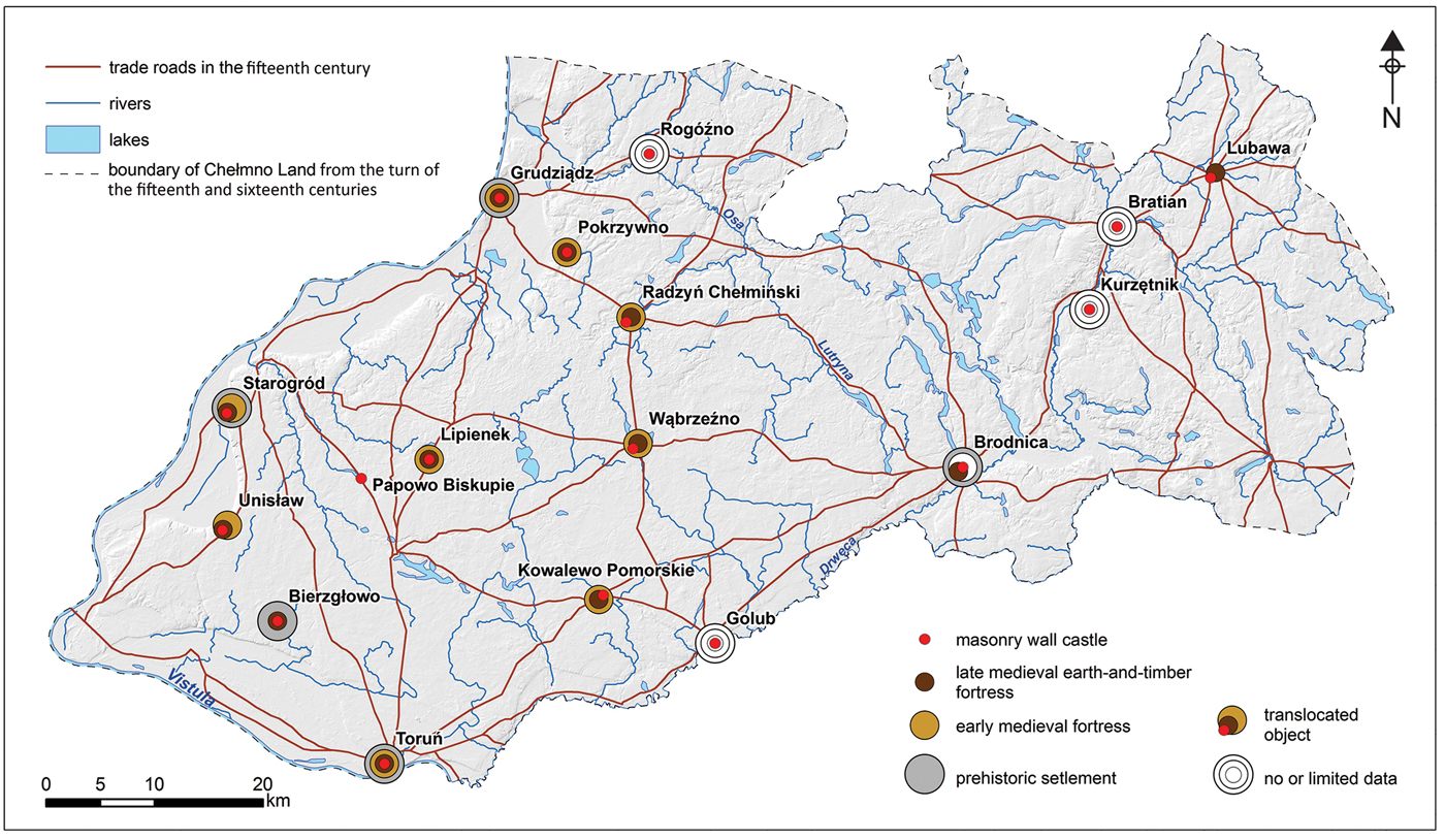
Figure 9. Transformations in Chełmno Land strongholds (fifteenth-century trade routes according to Bartoszewicz (Reference Bartoszewicz1996) (figure by B. Wasik & P. Molewski).

Figure 10. Models of transformations for Chełmno Land strongholds (figure by B. Wasik & P. Molewski).
This process—at least in Chełmno Land—is clear: in the 1230s, the Teutonic Knights built on former Slavic fortresses that had been previously abandoned, as attested in the so-called ‘Lonyz document’ (Jasiński Reference Jasiński and Nowak1992). This oldest group therefore included strongholds, which, in shape and layout, usually mirrored the earlier fortifications. Examples of such a process have been recorded in Toruń and Grudziądz (Chudziak & Kurzyńska Reference Chudziak, Kurzyńska and Wiewióra2012). Besides this early castle group, a further set of early Teutonic Order strongholds has also been identified. These are the so-called ‘transitional type’ or ‘colonising’ castles, which were built without reference to earlier defensive buildings (Kola Reference Kola1991; Kajzer Reference Kajzer1993). Nonetheless, a detailed discussion on the construction of the oldest Teutonic Order strongholds remains impossible, in part due to the limited investigation of these types of fortification. The ‘headquarters’ known from historical sources have so far not been located archaeologically, but they were certainly not associated with the later castles (Wasik & Wiewióra Reference Wasik and Wiewióra2016).
The investigations at Unisław have shown how the Teutonic Knights exploited the remnants of earlier fortifications (Figure 6). The oldest settlement was established in the ninth century and was inhabited until the end of the eleventh century. The stratigraphic record and radiocarbon dating from the earthen rampart suggest that the first rampart may have been built as early as this period (Table 1). If we accept this hypothesis, then the oldest rampart was built between the ninth and eleventh centuries, and was rebuilt in the 1280s by the Teutonic Knights. At that time, a commandry was created—one of the latest in this part of Prussia (Jóźwiak Reference Jóźwiak1997). Despite its late origins, this timber-and-earth building did not follow the typical Teutonic Order's architecture development pattern, in that it was not rebuilt as a masonry commandry castle. Analysis of the rampart interior, however, shows that during the Teutonic period, fired brick was already being used to construct the building's interior, as evidenced by the small pieces of brick found within the rampart's core.
In the second quarter of the fourteenth century, the commandry was dissolved and replaced with a procurator's district (Jóźwiak Reference Jóźwiak1997). The procurator was a lower-ranked official, whose responsibilities included issues related to the judiciary, administration and military command. At this time, work began on a brick structure at the site of the wooden stronghold. Only the main building of the castle was constructed in stone. The discovery of vaulting bricks indicates that one room (or rooms) in a ground floor of the building in Unisław were vaulted. The upper storeys had wooden floors, as evidenced by the narrowness of the walls beneath them. The ground floor of the building was walled in brick. The first floor, which had a separate entrance, was wood-framed, with wattle-and-daub construction. It is the only building of its type in Chełmno Land; most of the similar tower castles in Prussia are of a later, fourteenth-century date. The dimensions and layout indicate that it was not a tower, but a tower house of the Festes Haus or Hohen Haus type. In Central Europe, buildings of this type (e.g. at Dražice in Czechia, or Bakowa Góra and Bydlin in Poland) were larger, had thick walls, were three or four storeys tall, and with an entrance above ground level (Böhme et al. Reference Böhme, von der Dollen, Kerber, Mecksepr, Schock-Werner and Zeune1999; Lasek Reference Lasek2013).
The most surprising new information to emerge from the research at Unisław is that the construction of a timber-and-earth stronghold took place in the 1280s, after the end of conflict with the Prussian tribes, during a period of stability. Until now, the consensus has been that the new rectangular castles were employed during this period not only as functional commandry headquarters, but also to symbolise the power of the new state. In the 1280s, at nearby Papowo Biskupie, Bierzgłowski Castle and Starogród, large stone or brick buildings with irregular or regular layouts were either already in operation or in the initial stages of construction. Unisław, however, functioned for around 50 years as a timber-and-earth commandry headquarters. While it was not affected by the architectural transformations typical of this period, it employed a new and previously unknown technological innovation—a hypocaustum furnace—which clearly indicates the importance of the convent in existence here.
Considering the traditional trajectory of castle building in this region, it is difficult to explain why the commandry residence at Unisław was, and remained, a modest headquarters. Perhaps it could be explained by the rapidly changing administrative structure of the Teutonic Order's State. The final shape and layout of the defensive structure was undoubtedly influenced by the local topography, which significantly limited expansion. It is worth noting that the choice of building material (i.e. wood or brick) did not determine the social status or prestige of its owners, nor the building's function. Wooden castles were as aesthetically refined and sophisticated as were those in stone or brick. Military functions were neither the primary nor the only determinants of this type of architecture in the State of the Teutonic Order (see Higham & Barker Reference Higham and Barker1995). The evidence from Unisław, however, paints a new and more comprehensive picture—not only of settlement processes, but, crucially, of the transformation and development of defensive architecture in the conquered Prussian territories.
Acknowledgements
The research in Unisław was conducted as part of the research programme 2bH 15 0078 83, financed by the National Program for the Development of Humanities. Archaeobotanical analysis was carried out as part of the research programme 530-L145-D581-18.


