


Introduction
Geoarchaeological research conducted on cities situated on alluvial plains has long demonstrated the significant impact of river movement on urban development and landscape change though time (e.g. Mackay Reference Mackay1945; Arnaud-Fasseta et al. Reference Arnaud-Fassetta, Carcaud, Castanet and Salvador2010). Questions often raised in the scientific literature relate to the date and form of the occupation phases of these waterfront cities, the effects of urbanisation on the evolution of riverbanks and the associated constraints and risks for human occupation in such locations (e.g. Arnaud-Fasseta et al. Reference Arnaud-Fassetta2009; Morin et al. Reference Morin, Rodier, Laurent-Dehecq and Macaire2014). This is especially true in the Nile Valley, where large urban areas (notably harbours) have been heavily modified, and sometimes even buried, by river sedimentation and erosion (e.g. at the ancient capital, Tell ed-Daba/Avaris: Tronchère et al. Reference Tronchère, Goiran, Schmitt, Preussser, Bietak, Forstner-Müller and Callot2012) or West Thebes in Upper Egypt (Toonen et al. Reference Toonen2018).
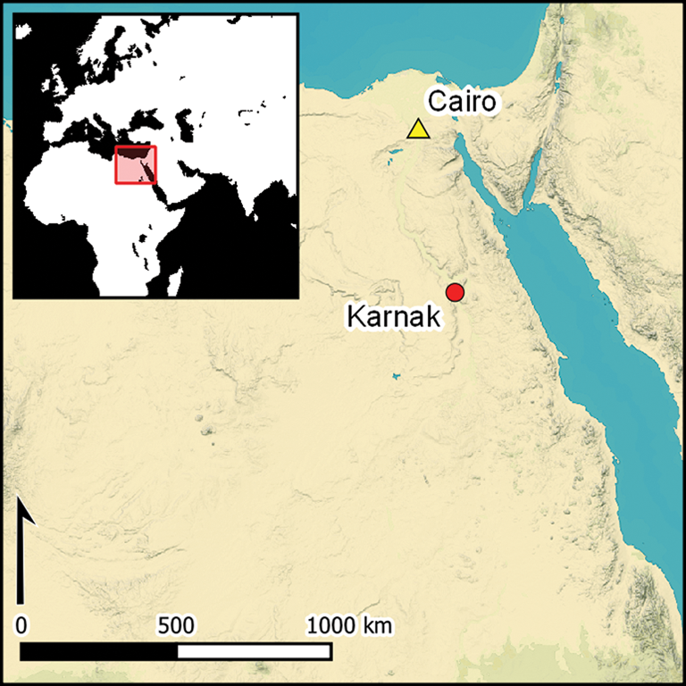
The famous site of Karnak (East Thebes; Figure 1) is of particular interest in this regard, as it emerged at the heart of the Nile floodplain some 4200–4100 years ago. Karnak was the main Egyptian religious complex for more than 2000 years (Sullivan Reference Sullivan and Wendrich2010). Scholars agree that the construction of an early sanctuary there dates to the reign of Antef II (c. 2118–2069 BC) of the Eleventh Dynasty (Le Saout et al. Reference Le Saout, Maarouf and Zimmer1987; Karnak Identifiant Unique n.d. 1). The city of Karnak itself, which surrounds the temple, was established in the early Middle Kingdom (2040–1780 BC; late Eleventh to Twelfth Dynasties), especially under the rule of Sesostris I (c. 1971–1926 BC) (Gabolde Reference Gabolde2000: 11; Ullmann Reference Ullmann, Dorman and Bryan2007; Moeller Reference Moeller2016: 300–303). The precise date and modalities of this urban development, and the link between the early sanctuary and the neighbouring town, however, remain poorly understood.
Figure 1. Location of Karnak in Egypt, in the central Nile Valley (© SRTM1N25E032, 1-ARC, NASA/USGS; map by G. Charloux).
The debate on the origin of the temples of Karnak started in the late eighteenth century, in particular with the Expedition to Egypt commissioned by Napoleon Bonaparte in 1798–1801. None of the results of subsequent nineteenth- and twentieth-century excavations (e.g. Legrain Reference Legrain1903), or from textual and epigraphic sources, provide a clear chronology. Karnak's origins could date to as early as the Old Kingdom (Table 1), as suggested by the list of sovereigns of the ‘Chamber of Ancestors’ in the Festival Hall of Thutmosis III at Karnak, or later, to the Middle Kingdom (Daumas Reference Daumas1967; contra Wildung Reference Wildung1969; Gabolde Reference Gabolde2000). Moreover, the Theban region has been occupied since the Pleistocene (e.g. Sandford & Arkell Reference Sandford and Arkell1933). A Predynastic presence, Old Kingdom tombs and artefacts in West Thebes, along with the first mention of the Theban nome (territorial division) in the Fourth Dynasty, document the early existence of settlements in the region (Reisner Reference Reisner1931; Eggebrecht Reference Eggebrecht1974; Saleh Reference Saleh1977). Recently, Gabolde (Reference Gabolde2018) has attempted to demonstrate a Predynastic origin for Karnak, while highlighting an absence of Old Kingdom occupation. Material and textual evidence of activity at Karnak pre-dating the First Intermediate Period is, however, of uncertain provenance and questionable date (see below).
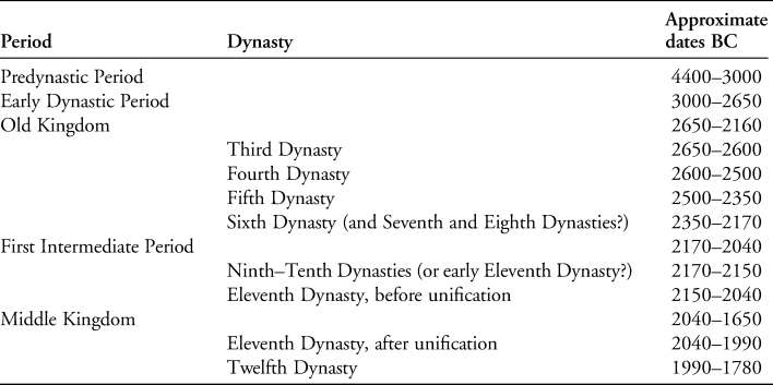
Table 1. Summary of the periods and dynasties in Thebes mentioned in the article.
Over the past 20 years, archaeological work and geomorphological surveys at Karnak have greatly improved our knowledge of site-formation processes and of the architectural configuration of religious buildings (e.g. Charloux Reference Charloux2007; Bunbury et al. Reference Bunbury, Graham and Hunter2008; Charloux & Mensan Reference Charloux and Mensan2011). Recent excavations in the temple of Ptah (Charloux et al. Reference Charloux, Durand, Abady Mahmoud and Elnasseh2017) have provided the first stratified archaeological sequence at Karnak, dated by radiocarbon assay and ceramic typology. This work allows us to trace more precisely the extent of early human settlement there.
Here, we attempt to demonstrate that Karnak developed considerably towards the west during the Eleventh Dynasty, following human occupation of the Nile banks. The origin of the settlement was a hill located to the south-east of the Karnak precinct, where the oldest presence of the First Intermediate Period and possibly even the late Old Kingdom was uncovered (Millet Reference Millet2008; Millet & Masson Reference Millet, Masson and Wendrich2011). Made possible by the appearance of new land, this extension of occupation probably started at the end of the Old Kingdom or in the early First Intermediate Period (around 2200 BC), and continued throughout the late third millennium BC (and later; see Hillier et al. Reference Hillier, Bunbury and Graham2007; Boraik et al. Reference Boraik, Gabolde, Graham, Dahm and Willems2016). This formation process was potentially caused by demographic growth and in spite of the risk of floods. We therefore suggest that the rise of Karnak, c. 2150–2000 BC, was probably shaped by a central authority—presumably the Theban rulers of the early and middle Eleventh Dynasty. Thus, the river and the Karnak settlement played major roles in the wider shifts in religious and political power of the early Egyptian state.
The original landscape
An understanding of the palaeoenvironmental context of the site provides an essential basis for interpreting the evolution of the first establishment at Karnak. This is particularly helpful, given the absence of any ancient Egyptian documentation describing the early temple and its local environment. Several twentieth-century investigations attempted to clarify this situation but with only partial success (e.g. Legrain Reference Legrain1903).
Situated on the current eastern edge of the Nile's alluvial plain, Karnak has had a turbulent history linked to fluctuations of the river (Hillier et al. Reference Hillier, Bunbury and Graham2007; Gabolde Reference Gabolde2018). Locating palaeochannels and investigating the river dynamics from antiquity to the present day make it possible to delimit more clearly the areas occupied in each period, and to trace the development of the religious complex and the processional routes followed on river and land. To address these aims, since 2002 a team led by A. Graham (initially as part of the Karnak Land- and Waterscapes Survey in collaboration with J. Bunbury and, since 2011, as part of the Theban Harbours and Waterscapes Survey) has been drilling deep cores in the local landscape (Graham & Bunbury Reference Graham and Bunbury2005) (Figure 2). Simultaneously, deep archaeological trenches were opened between 2001 and 2016 by the Centre Franco-Égyptien d’Étude des Temples de Karnak (CFEETK hereafter) team, at the cardinal points of the Amun complex (east: Millet Reference Millet2007, Reference Millet2008; south: Charloux et al. Reference Charloux, Angevin, Marchand, Monchot, Roberson and Virenque2012; north: Charloux et al. Reference Charloux, Durand, Abady Mahmoud and Elnasseh2017; centre: Charloux & Jet Reference Charloux and Jet2007; Lanoë Reference Lanoë2007; Charloux & Mensan Reference Charloux and Mensan2011; Le Bohec & Millet Reference Le Bohec and Millet2012). Coring was also undertaken in front of the temple quay to the west (Ghilardi & Boraik Reference Ghilardi and Boraik2011).
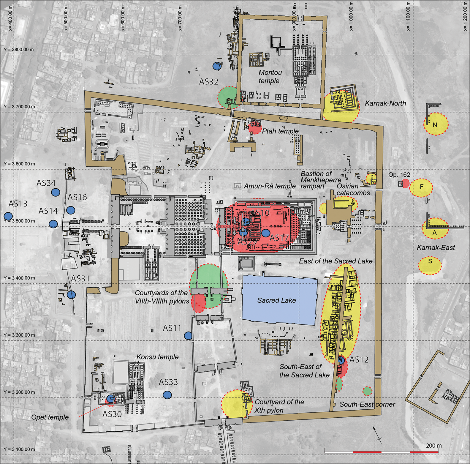
Figure 2. Location map of fully or partially published archaeological trenches reaching levels of the First Intermediate Period and the early Middle Kingdom at Karnak. Recent excavations (after 2000) in red; modern excavations (1970–2000) in yellow; early excavations in green (Legrain (Reference Legrain1903); Franchet (Reference Franchet1917); Christophe (Reference Christophe1951); Lortet, in Vergnieux (Reference Vergnieux1982)); blue dots are recent cores (Graham team) (© CNRS-Ptah Archaeological Project, G. Charloux; © CFEETK; © CNES 2014, Distribution Airbus DS).
The results from this research suggest that a Nile bank existed west of the Temple of Amun in the early Middle Kingdom (Bunbury et al. Reference Bunbury, Graham and Hunter2008; Charloux & Mensan Reference Charloux and Mensan2011). This riverbank is characterised by deposits of coarse yellow sand containing no anthropogenic material, covered by silty and sandy layers deposited during flooding episodes. These layers often contain small, rolled pottery sherds, attesting to continuous movement of the river. All of the layers show a pronounced slope towards the west, which we also observed near the early sanctuary, under the courtyards of the fourth to sixth pylons (massive gateway structures; Charloux & Mensan Reference Charloux and Mensan2011) and of the seventh to eighth pylons (Legrain Reference Legrain1903: 22–25). Coring farther south, supplemented by geophysical surveys, confirmed the existence of a palaeochannel east of the temple of Khonsu in the Amun complex (Bunbury et al. Reference Bunbury, Graham and Hunter2008: 362; core AS11) and beneath the dromos (ceremonial avenue flanked by statues) of the temple of Mut in South Karnak (Lauffray Reference Lauffray1968: 337–51; Anus et al. Reference Anus, Lauffray and Sauneron1969: 124). Furthermore, a comparison between cores AS30 and 33 (Figure 2) and the coarse and medium sand beneath the flood deposits at the temple of Opet suggests the existence of an island in this location (Graham Reference Graham2010a).
At Karnak-North, an east-west channel of the Nile was also observed during earlier excavations and in recent drilling (Christophe Reference Christophe1951: 82; Jacquet Reference Jacquet2001; Bunbury et al. Reference Bunbury, Graham and Hunter2008). A similar situation was described in 2005 to the east of the Karnak religious complex (Ismail et al. Reference Ismail, Anderson and Rogers2005). This is supported by the presence of ancient houses found placed on a slope towards the east (Redford Reference Redford1988: fig. 8). Finally, a swampy area may have been present between the ninth pylon and the Sacred Lake (Anus et al. Reference Anus, Lauffray and Sauneron1969: 124), perhaps even in the “courtyard of the Middle Kingdom” (Charloux & Mensan Reference Charloux and Mensan2011: 69). To explain these elements, Graham and his team proposed that the Karnak site occupied several islands that were progressively agglomerated during the Middle Kingdom (Graham Reference Graham2010a & Reference Graham, Bietak, Czerny and Forstner-Müllerb).
Reconstructing the anthropogenic sequence at Karnak
The palaeoenvironmental data appear to be consistent with the results obtained from the recent excavation at the Ptah temple in the northern part of the Karnak complex, which allow us to describe and date natural events and anthropogenic activities there. Between October 2015 and February 2016, we dug a trench south of the Ptah temple (Figure 3). The excavation revealed 30 distinct archaeological phases (Figure 4). These phases are distributed over seven levels between 71.60 and 76.80m asl. Two underlying levels (0 and −1) were identified during augering to a depth of 66.87m asl (Pennington Reference Pennington2018) (Figure 5). The 10m-deep stratigraphic profile revealed within the trench provides a complete overview of the site's occupation sequence, from its geological substrate to its abandonment.
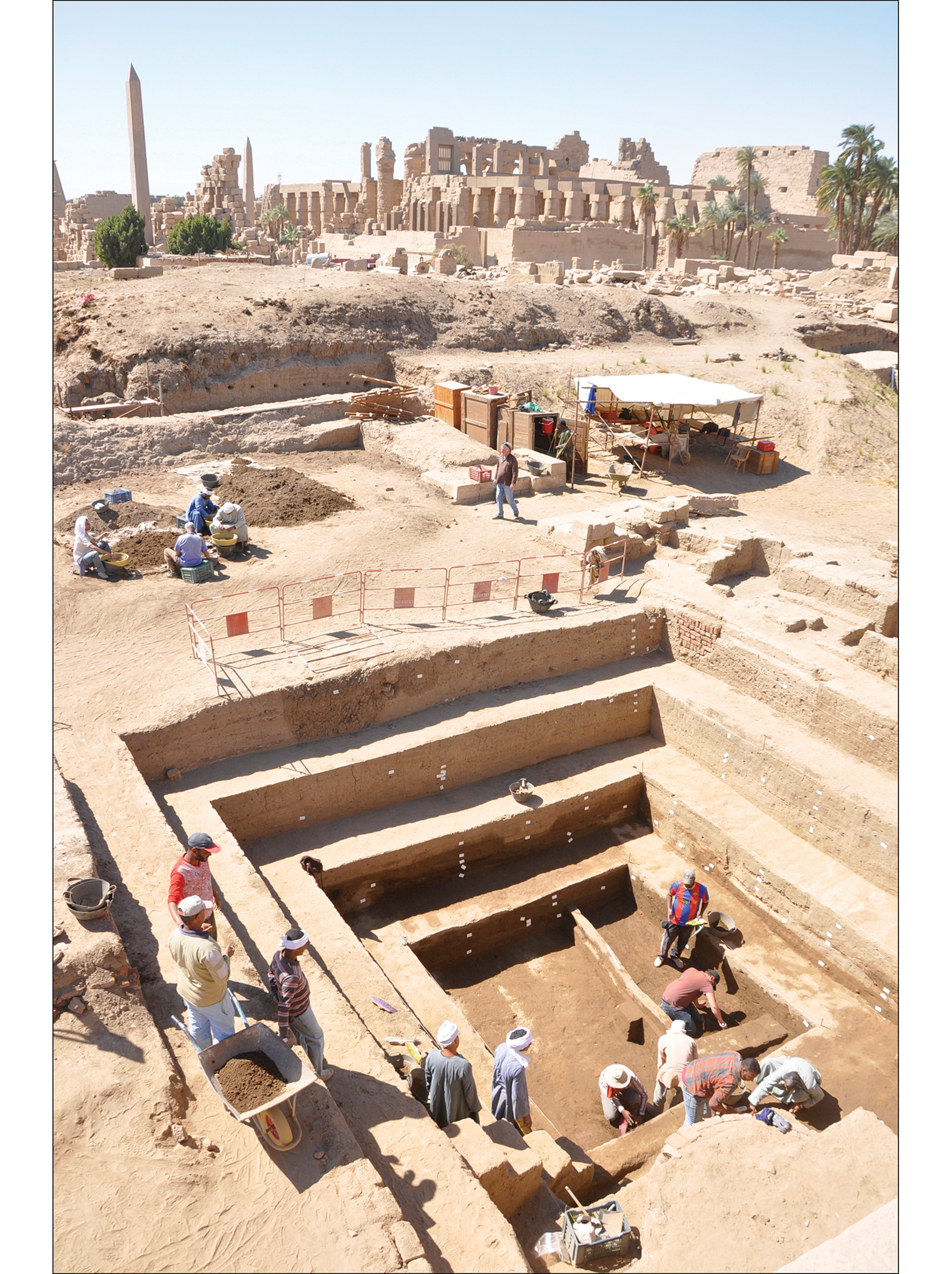
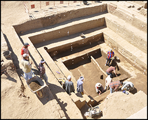
Figure 3. Archaeological trench to the south of the Ptah temple in Karnak: level 2 during excavation (photograph taken in 2016 by G. Charloux, © CNRS-Ptah Archaeological Project).
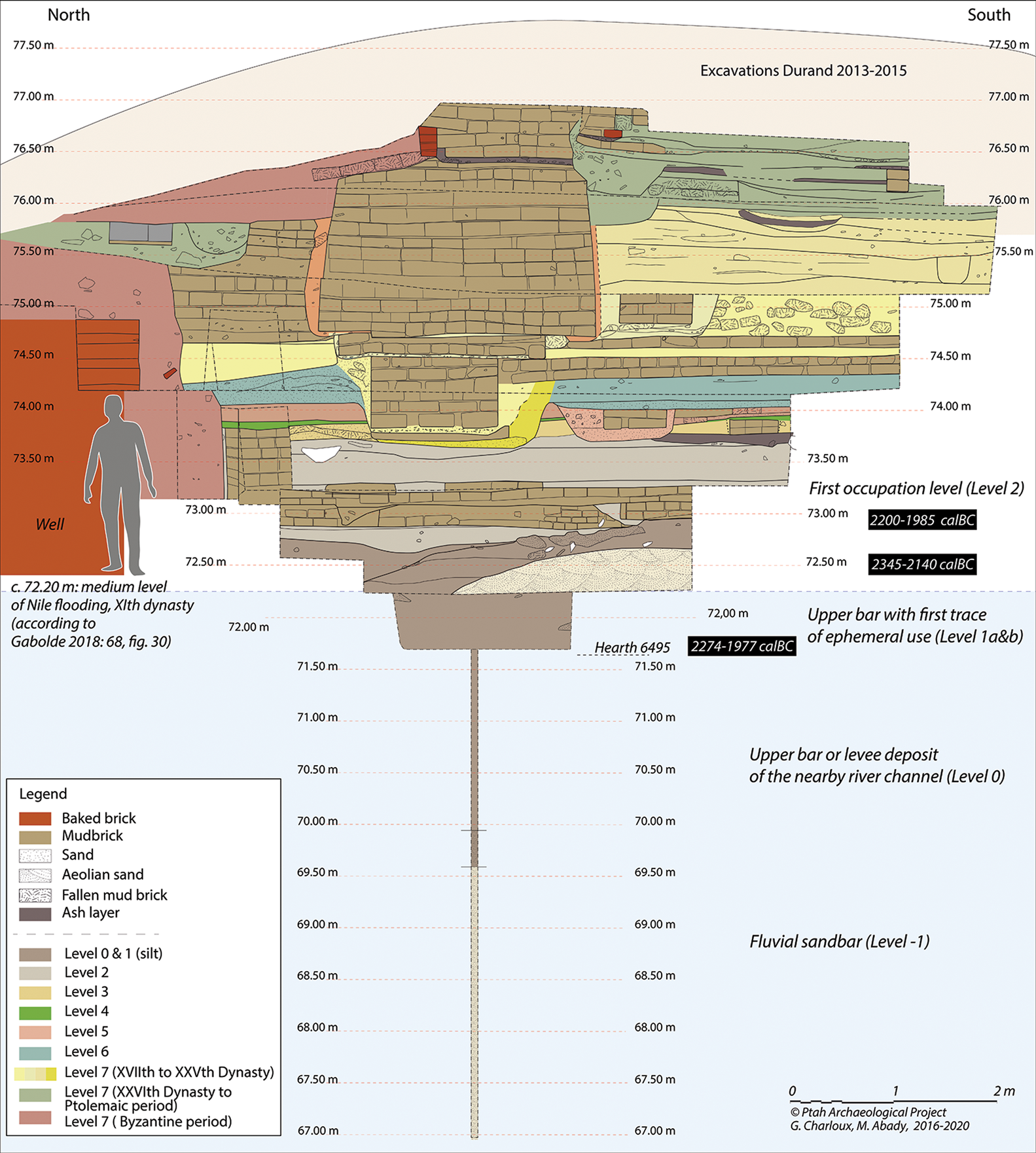
Figure 4. Stratigraphic sequence of the deep trench (eastern section) (figure by G. Charloux & M. Abady, © CNRS-Ptah Archaeological Project).
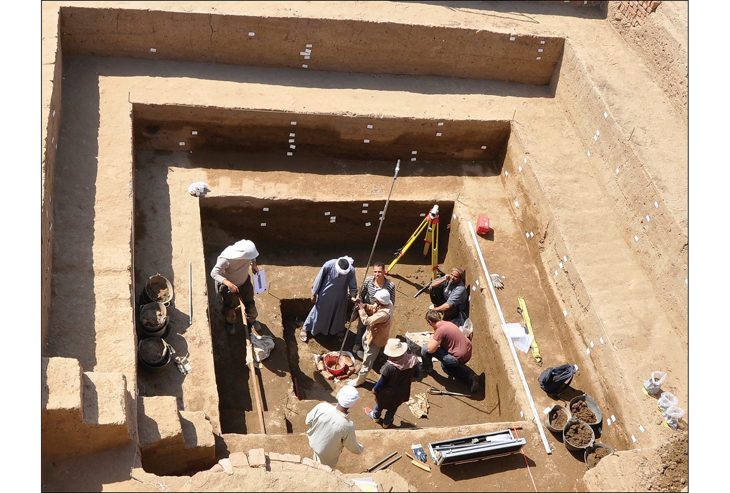
Figure 5. Augering at the bottom of the trench (photograph by G. Charloux, © CNRS-Ptah Archaeological Project).
At the base of the stratigraphy is a typical fluvial sandbar (level −1), covered by an upper bar (level 0) with a marked slope descending towards the north-west (see the online supplementary material (OSM)). A small domestic hearth (level 1a) was installed above this (Figure 6). This represents the first evidence of human activity on the river bank and is dated to the middle of the Eleventh Dynasty, according to ceramic typology and radiocarbon-dating (2193–1978 cal BC). Natural flood and windblown sediments then accumulated above the hearth (level 1b). Although most of the material recovered from level 1b dates to the Eleventh Dynasty, two typical, heavily eroded Meidum bowl sherds date to the late Old Kingdom. These represent traces of an earlier, upstream occupation, confirmed by radiocarbon-dating of wood charcoal (Acacia nilotica) from deposit US6486 (2345–2140 cal BC), suggesting that an area farther to the south-east had probably been occupied in this period (see below).
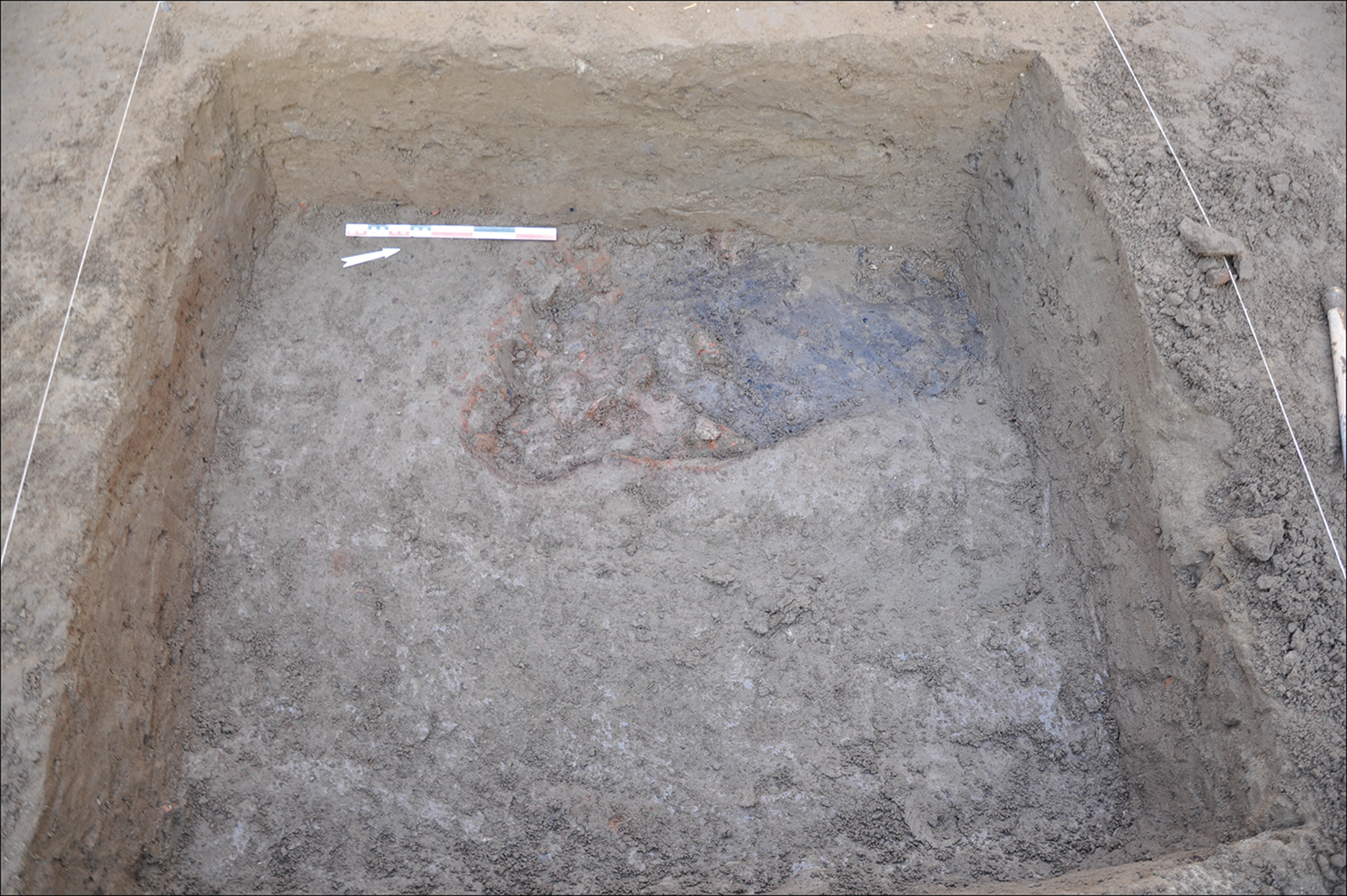
Figure 6. The hearth US6495 (photograph by G. Charloux, © CNRS-Ptah Archaeological Project).
Level 2 corresponds to the first building phase in the area (Figure 7), with seven architectural phases (3–9) identified. This domestic level ends with the abandonment and collapse of the structure. Later ephemeral remains follow, constituting level 3.
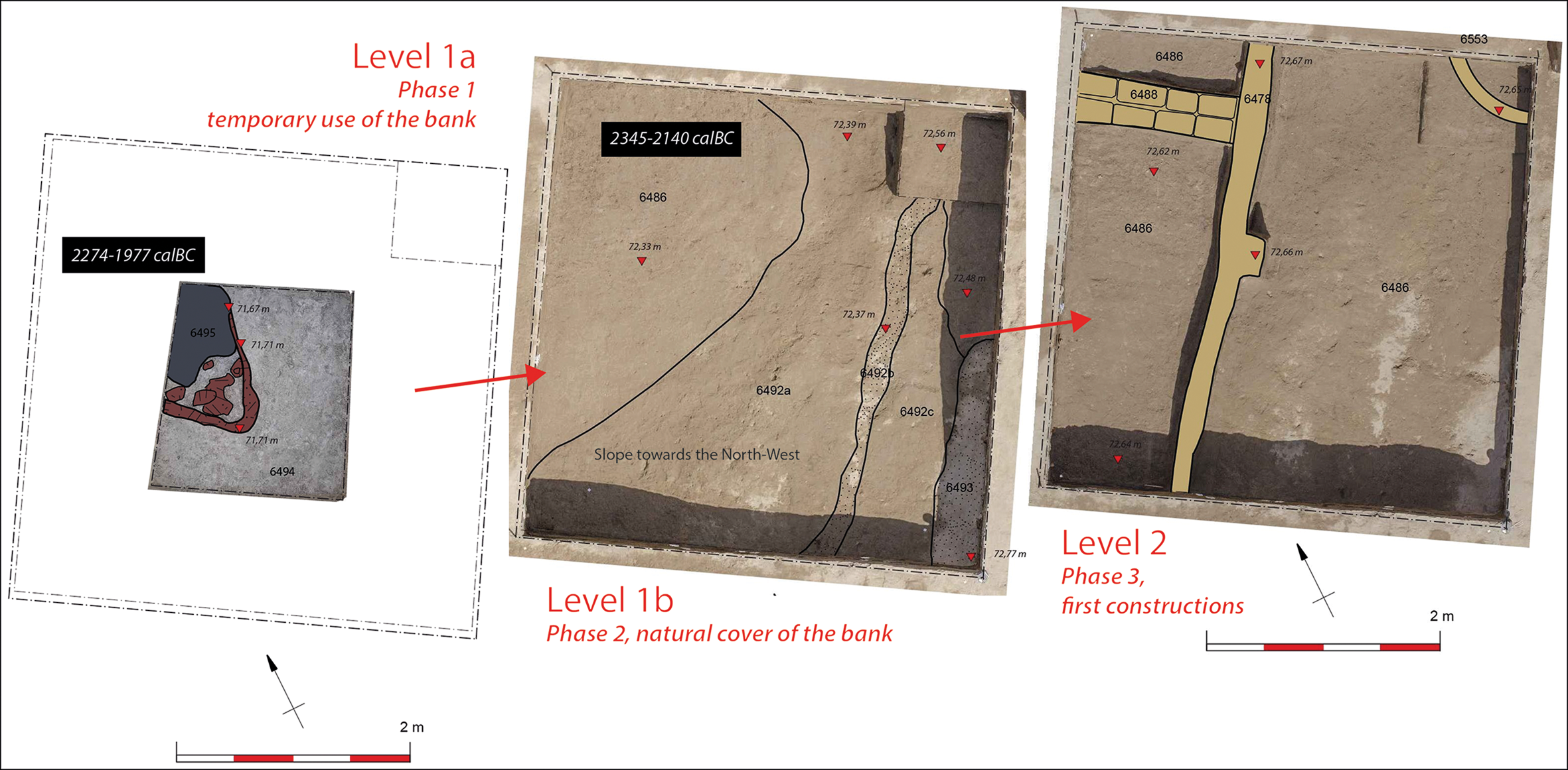
Figure 7. Plan of phases 1–2 (level 1) and 3 (level 2), and of the level 2 mud-brick remains (phase 3) (figure by G. Charloux & P. Mégard, © CNRS- Ptah Archaeological Project).
The pottery from level 2 suggests a date ranging from the late Eleventh Dynasty to the beginning of the Twelfth Dynasty. This corresponds with the two radiocarbon dates from phase 8 (2200–1985 cal BC and 2200–2023 cal BC) (Figure 8). The relative imprecision of radiocarbon-dating does not allow for chronological differentiation between levels 2 and 1. Analysis of the ceramic assemblage provides greater precision, showing a reasonably clear difference between level 1 (mid Eleventh Dynasty) and level 2 (late Eleventh to early Twelfth Dynasties).
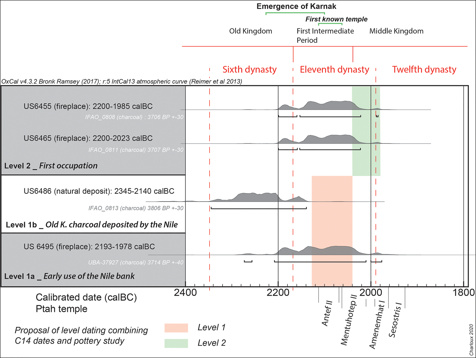
Figure 8. Radiocarbon dates from Karnak (calibrated using OxCal v.4.3.2 and the IntCal13 calibration curve (Reimer et al. Reference Reimer2013; Bronk Ramsey Reference Bronk Ramsey2017)), with a simplified chronology (see Table 1) (figure by G. Charloux, © CNRS- Ptah Archaeological Project).
These data demonstrate that the first use of the Nile bank in the area of the temple of Ptah pre-dates the first dwellings in the First Intermediate Period (mid to late Eleventh Dynasty) by a few decades.
The urban expansion of Karnak during the Eleventh Dynasty
Few excavations have reached the deepest levels at Karnak—the natural substrate and the layers containing the remains of the earliest settlement—while also covering areas of useful size. While older archaeological records (e.g. Legrain Reference Legrain1903; Lortet, in Vergnieux Reference Vergnieux1982) offer interesting clues for the restitution of the palaeolandscape, inferences drawn from incomplete or unstratified material are inevitably inconclusive. Unfortunately, more recent projects have also often provided only partial documentation (e.g. Van Siclen Reference Van Siclen2005) (Figure 2).
East of the Amun temple
Although still unpublished, research conducted in the Osirian catacombs (location on Figure 2) has reached domestic levels, notably characterised by the presence of silos, and dating to the First Intermediate Period/Eleventh Dynasty (see Leclère Reference Leclère2002; Marchand, in Gabolde Reference Gabolde2018: 155). A nearby unpublished sounding, opened on a bastion of the rampart built by Menkheperre, also reached an Eleventh Dynasty level (S. Marchand pers. comm.).
East and south-east of the Sacred Lake
Excavations to the east of the Sacred Lake in the 1970s (Figure 2) reached the deeper levels of the sector, but not the natural substrate (Lauffray Reference Lauffray1980: 47–50; Debono Reference Debono1982: 378, Reference Debono1987). Debono identified some putative Old Kingdom ceramic sherds beneath levels dated approximately to between the Ninth and Twelfth dynasties (Lauffray Reference Lauffray1980: 47–49). Examination of a set of old drawings of this pottery makes it possible to distinguish two ceramic assemblages, one from the Sixth to Eleventh Dynasties and one of the Eleventh Dynasty (Millet Reference Millet2008: 320–21).
More recently, a trench opened to the south of the previous one (Figure 2) reached the earliest levels of the site (Millet Reference Millet2007, Reference Millet2008). From top to bottom, phases 2, 1 and 0 represent Eleventh Dynasty occupation. Below that levels –1 to –3 were encountered. Covered by flood deposits distinctly sloping towards the east (phase –1), a small building with a mud-brick staircase (phase –2) was built on a clay layer, which contained material from the Sixth Dynasty and the early First Intermediate Period (phase –3). Below this level, coring revealed a succession of sand and silt layers interspersed with anthropogenic material over 2m thick, before reaching fluvial sands and laminated mud layers (Bunbury et al. Reference Bunbury, Graham and Hunter2008). This suggests a short phase of human activity on the river bank during the Sixth Dynasty to the early First Intermediate Period, with more persistent occupation established later in the early Eleventh Dynasty.
South-east corner
The evidence to the east and south-east of the Sacred Lake resembles that encountered by Franchet (Reference Franchet1917) in the south-east corner of the Amun precinct, despite incomplete documentation (Millet Reference Millet2008; Gabolde Reference Gabolde2018). Here, the “Eneolithic level”, under a sterile layer (Franchet Reference Franchet1917: 87), resembles phases −2/−3 of the Millet trench described above. This level cannot be dated with certainty, as contextual information is missing and it probably contained mixed material (Millet Reference Millet2008: 319; R. Angevin pers. comm.).
East Karnak
The examination of ceramics from East Karnak suggests Eleventh and Twelfth Dynasty occupation in areas A, B, E, F, N and S (Figure 2; Redford Reference Redford1996: 4, note 2; Marchand, in Gabolde Reference Gabolde2018: 154–66). This dating is further supported by the identification of three First Intermediate Period architectural phases in a nearby unpublished trench (Laroze & Valbelle Reference Laroze and Valbelle2010: 26). The local groundwater table prevented investigation at deeper levels.
South-west Karnak
At the temple of Opet (Figure 2), the coarse natural Nile sand was buried beneath three thin flood layers identified in coring and dated by the presence of ceramics to the late Eleventh to early Twelfth Dynasties. Above these, evidence for the first occupation dates to the same period (Charloux et al. Reference Charloux, Angevin, Marchand, Monchot, Roberson and Virenque2012: 255).
North Karnak
To the west of the Montu temple, near the gate of Ptah, Christophe (Reference Christophe1951: 82) encountered a sequence with structures established above an ancient bank but without any dating evidence, comparable to that found in our 2015–2016 Ptah temple trench. Farther east, under and near the Treasury of Thutmosis I, Jacquet (Reference Jacquet1983: 80 & 95, Reference Jacquet1994: 9, Reference Jacquet2001: 13–14) identified an initial occupation characterised by narrow walls built on a sloping terrain, and a 2.50m-thick embankment. The material from room A50—in one of the deepest levels of the excavation—probably dates to the late Eleventh Dynasty to the beginning of the Twelfth Dynasty (Jacquet-Gordon Reference Jacquet-Gordon2012). The contours recorded during excavation revealed a marked slope towards the north-west.
South Karnak
Excavations by M. Azim in the courtyard of the tenth pylon and farther south at the temple of Mut (Fazzini & Peck Reference Fazzini and Peck1982: 44; Bryan Reference Bryan2009: 32, fig. 10) did not reach levels that pre-date the Twelfth Dynasty.
Karnak centre: the temple of Amun
Despite the scarcity of Eleventh Dynasty textual sources (Gabolde Reference Gabolde2018: 224–360), the existence of an early temple of Amun at Karnak is attested by two pieces of evidence. First, the sandstone pillar of Antef II (or III) (c. 2118–2069 BC) discovered in the “courtyard of the Middle Kingdom” (Le Saout et al. Reference Le Saout, Maarouf and Zimmer1987: 294–97; Karnak Identifiant Unique n.d. 1), and second, mention of a temple of Amun on two contemporaneous stelae (Clère & Vandier Reference Clère and Vandier1948; Vandier Reference Vandier1964; Gabolde Reference Gabolde2018: 187).
Recent excavations have enabled a partial reconstruction of the chronological phases of Ipet-isut (the Karnak sanctuary area), which was also established on an ancient bank of the Nile (Charloux & Mensan Reference Charloux and Mensan2011). The sand-silt and clay-silt layers into which the mud-brick foundations of the first temples were dug have a terminus post quem of the Eleventh to early Twelfth Dynasties, according to pottery analysis. The upper part of the stratigraphic sequence, with a terminus post quem of the late Eleventh to early Twelfth Dynasties, coincides with the oldest textual evidence. The archaeological investigations confirm the existence of massive, planned structures. Our assessment of the function of these foundations, based on the architectural sustainability of mud-brick buildings, gradually replaced by limestone and sandstone, concluded that the walls and enclosures that linked the mud-brick pylons surrounded storerooms, chapels and the sanctuary of the divinity for nearly 600 years. The main elements of the architectural history of the first temples of Amun, about which nothing was known 20 years ago, have now been outlined (compare Charloux (Reference Charloux2007) and Charloux and Mensan (Reference Charloux and Mensan2011) with Gabolde (1998: pl. I); see also Carlotti et al. (Reference Carlotti, Czerny and Gabolde2010) and Larché (Reference Larché2020), but with discrepancies on the overall restitution).
Discussion
The stratified sequence revealed in our trench at the temple of Ptah allows for reliable contextualisation of the natural and anthropogenic deposits, providing a set of secure radiocarbon and ceramic dates. This evidence enables us to date the initial use of the riverbank and its overlap with the first occupation in the Karnak complex, placing previous results from other areas into perspective. Consequently, we can now reconsider the development of early Karnak (Figure 9).
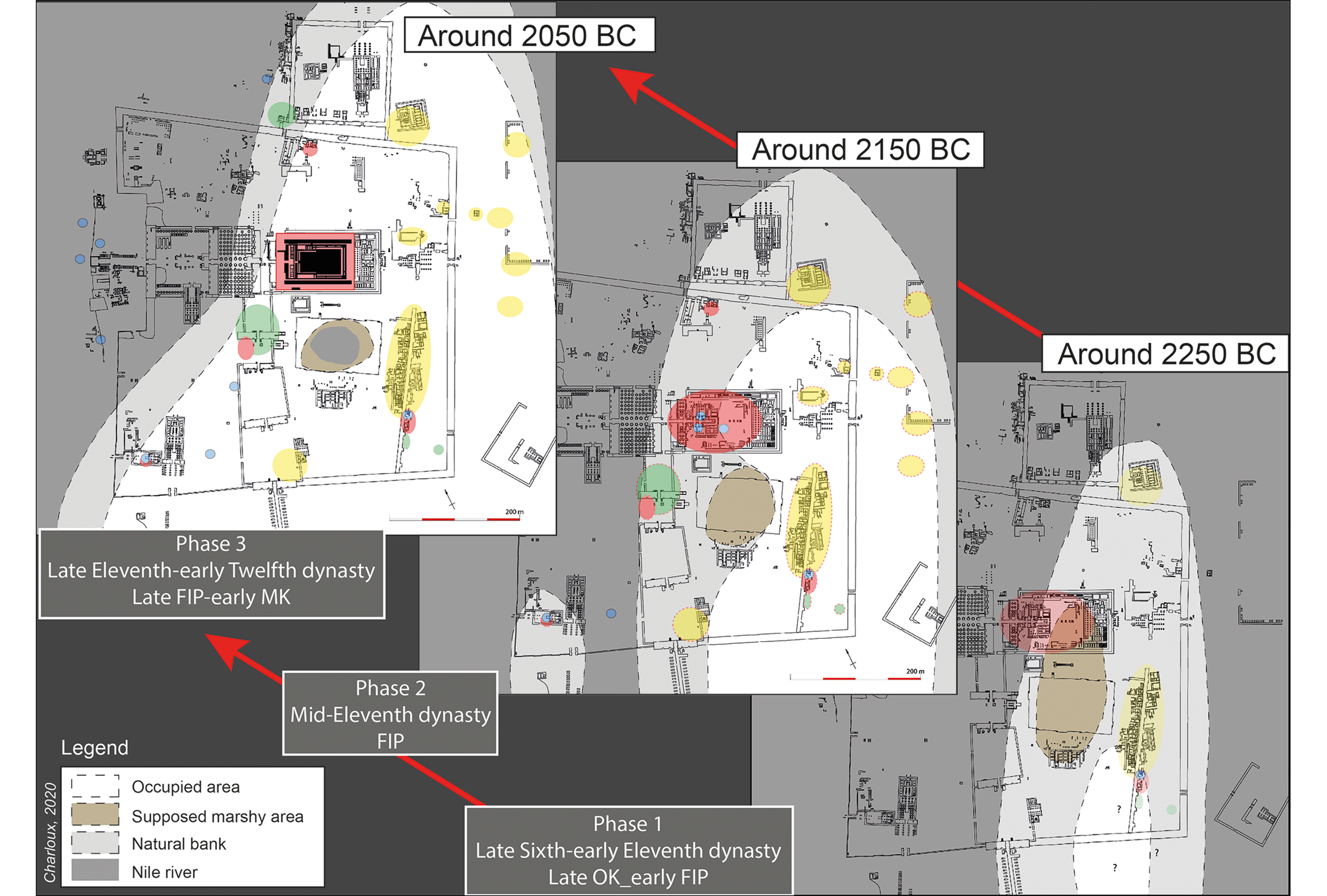
Figure 9. Reconstruction of the landscape and urban development of Karnak during the Eleventh Dynasty. OK = Old Kingdom; FIP = First Intermediate Period; MK = Middle Kingdom (figure by G. Charloux, © CNRS-Ptah Archaeological Project).
First, let us consider the palaeotopography of the area. The elevations above sea level of the first occupation revealed in deep excavations show that the surface of the site slopes markedly towards the west (Figure 10), as previously identified by several researchers (e.g. Millet Reference Millet2008; Gabolde Reference Gabolde2018). A natural mound to the east of the Karnak complex, presumably an island, was delimited to the east and west by a palaeochannel. Over time, the Nile gradually withdrew towards the west, while widespread, long-term occupation was established on this site. At the same time, a palaeochannel to the east of the current precinct constituted the eastern limit of the hill. At the location of the temple of Ptah the river bank was covered by flood deposits (level 1b) after a first, ephemeral use (level 1a) in the middle of the Eleventh Dynasty, and then by domestic activity (level 2) during the late Eleventh to early Twelfth Dynasties. This latter level comprised seven successive architectural phases, which we believe span at least 100 years. Thus, it seems that the westward progression of the river bank was achieved by c. 2150–2050 BC. This process implies an extension of the inhabited area at the expense of the Nile bank. It also seems that the palaeochannel must have gradually moved after its partial natural filling. The same phenomenon of riverbank extension towards the west seems to have occurred in the area of the temple of Amun (Charloux & Mensan Reference Charloux and Mensan2011) and farther west at a later date (Hillier et al. Reference Hillier, Bunbury and Graham2007: fig. 1). We assume that the building of new mud-brick structures around the site of the early sanctuary at Karnak was probably in response to population growth. This trend must have pushed the settlement farther towards the riverbank, regardless of the flood risk. It has recently been established that the average level of the Nile floods during the Eleventh Dynasty was approximately 72.20m asl (Gabolde Reference Gabolde2018: 68, fig. 30), that is, only 0.70m below the level 2 occupation above the Nile silts. Subsequently, this deposit was barely able to protect the settlement from the movement and exceptional flooding of the river.
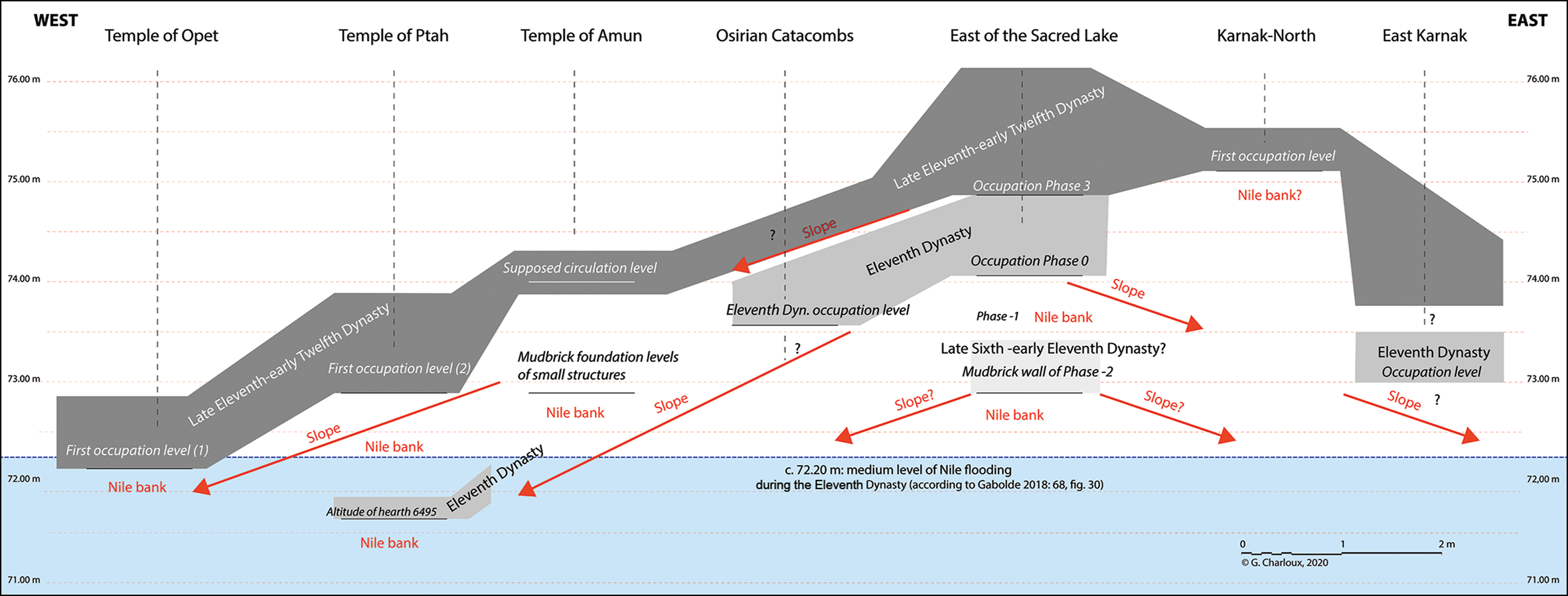
Figure 10. Reconstruction of the slopes on both sides of the Amun area at Karnak, based on the depth and dates of the earliest levels reached at the site (figure by G. Charloux, © CNRS-Ptah Archaeological Project).
Palaeotopography may also explain the later establishment of a settlement on the ‘island’ of Opet, 350m south-west of the temple of Amun, which was previously uninhabitable due to the threat of recurrent flooding (Figure 10). Such an event is related later, for example in the ‘Flood stele’ of Sobekhotep VII that recounts the submersion of the courtyard of the temple of Amun c. 1650 BC (Baines Reference Baines1974; Gabolde Reference Gabolde2018: 60). Despite such risks, significant population growth must have caused the encroachment on the Nile bank towards the west. This growth was probably linked to the economic and religious appeal of the site, but perhaps also because it was favoured by a central authority. Such an encroachment on a river under state control is not unique, and can be compared to the situation in early Rome, for example (Ammerman Reference Ammerman2018). The development of the city of Thebes around the temple of the main god led to the creation of the new capital of Egypt, consolidating the growing power of Thebes and its ruling dynasty.
Chronologically, it appears that the settlement at Karnak developed during the Eleventh Dynasty. We cannot exclude the existence of a late Old Kingdom phase to the south-east of the temple, but this currently remains unknown (Millet Reference Millet2008). Material from the late Old Kingdom and early First Intermediate Period in the three deepest levels comes from riverbank contexts and flood deposits. Radiocarbon-dated charcoal and two Meidum bowl sherds from our trench at the temple of Ptah were displaced from a site located farther to the south-east. Conversely, the contextualised material obtained from the Ptah excavations highlights the existence of built levels (settlement or other) in the middle and especially the late Eleventh Dynasty. This is also valid for the north, south and east of the precinct of Amun, although the windows opened onto these areas are admittedly very narrow, and these zones may have been surrounded by uninhabited and cultivated areas. Nevertheless, the image that emerges is of a large site, already covering approximately 15ha by around 4000 years BP.
Considering earlier archaeological evidence and in particular its excavated ceramic assemblages, it seems that the first settlement was established in south-east Karnak before the construction of the temple of Amun at its current location. Like the rest of the ancient city, the temple surely already existed under Antef II (or III), and was gradually extended towards the west (Charloux & Mensan Reference Charloux and Mensan2011). We also know that the famous conquests of the Eleventh Dynasty relied heavily on the population of Thebes (Grajetzki Reference Grajetzki2006: 10–28). While textual sources concerning the Eleventh Dynasty rulers are sparse at Karnak (Gabolde Reference Gabolde2018: 170–88), the role of the latter in Thebes was essential. This is supported by the rise of the necropolis in western Thebes (Seidlmayer Reference Seidlmayer and Shaw2000: 133–34), the establishment of a procession honouring Amun in the reign of Mentuhotep II (Ullmann Reference Ullmann, Dorman and Bryan2007: 8), and the erection of this king's funerary temple at Deir el-Bahari in western Thebes (Arnold Reference Arnold1974). This monument refers to Amun on numerous occasions and is aligned on the same axis as the Karnak temple. It is therefore likely that the temple of Amun underwent major redevelopment under Mentuhotep II, ‘founder’ of the Middle Kingdom, and a Theban native. Moreover, this would correspond perfectly with the dates obtained by our investigations. At the same time, this perspective does not diminish the major activity of the Twelfth Dynasty pharaohs Amenemhat I and Sesostris I. Their presence is well documented by the many inscriptions found at Karnak (Gabolde Reference Gabolde2018: 198–200 & 205–22), as well as by the apparent re-planning of the ancient city by the central administration in the early Twelfth Dynasty (Redford et al. Reference Redford, Orel, Redford and Shubert1991: 96; Kemp Reference Kemp2006: 225–29).
To conclude, it is reasonable to suggest that, by 2000 BC, the temple of Amun had already been surrounded by residential areas on all sides for more than a century. The temple of Amun and the new capital city of Karnak most probably developed in parallel with the gradual takeover of Egypt by the Theban rulers of the Eleventh Dynasty. Our study reveals that the shifting Nile and Karnak's relationship with the river played essential roles in the rise of Thebes and a new political force in Egypt.
Acknowledgements
We thank the Ministry of Tourism and Antiquity of Egypt, CNRS, CFEETK and the French Ministry of Foreign Affairs for their support. We also address our sincerest thanks to Christophe Thiers, director of the Ptah temple study and former director of the CFEETK, for allowing us to publish this research. We warmly thank Benjamin Pennington (Theban Harbours and Waterscapes Survey team) for his study of the augered sediments from our trench. The views expressed in this article are solely those of the authors.
Funding statement
The project is supported by LabEx Archimede, ‘Investissement d'Avenir’ (ANR-11-LABX-0032-01).
Supplementary material
To view supplementary material for this article, please visit https://doi.org/10.15184/aqy.2021.73


