


Introduction
The lower half of the Niger River's course lies within one of the most archaeologically under-explored regions of the world. Yet this area includes first- and early second-millennium AD archaeological evidence of considerable significance. Lying downriver of the well-published site of Gao (Insoll Reference Insoll1996, Reference Insoll2000; Cissé et al. Reference Cissé, McIntosh, Dussubieux, Fenn, Gallagher and Chipps Smith2013), it includes, along some 500km, sites such as the necropolis of Bura, with its world-renowned figurative terracottas (Gado Reference Gado and Devisse1993); its better-published counterpart Kissi (Magnavita Reference Magnavita, Magnavita, Koté, Breunig and Idé2009, Reference Magnavita2015); the tenth-century settlement of Oursi (Petit et al. Reference Petit, von Czerniewicz and Pelzer2011); and the mound sites of the Kainji area with their pottery pavements and figurines (Nzewunwa Reference Nzewunwa1983; Sule & Haour Reference Sule and Haour2014), all against a backdrop of densely distributed archaeological materials (Gado Reference Gado1980; Haour et al. Reference Haour, Winton, Idé, Rendell and Clarke2006).
Recent research is rebalancing the picture following decades of scholarly focus on the western Sahel, and is showing the importance of this eastern arc of the Niger, including relating to questions of trans-Saharan trade (Nixon et al. Reference Nixon, Rehren and Guerra2011; Magnavita Reference Magnavita2013, Reference Magnavita2015). For instance, the cemetery site of Kissi (Burkina Faso) demonstrates exchange of some kind with North Africa throughout the first millennium AD (Magnavita Reference Magnavita, Magnavita, Koté, Breunig and Idé2009, Reference Magnavita2015), a scenario confirmed by recent results from the Republic of Niger (Magnavita Reference Magnavita2013). The eastern arc of the Niger River was also central in the later development of large-scale polities such as the Songhai ‘empire’ along the Niger. Extensive debate has surrounded the routes travelled by North African and/or Indian beads recovered from contexts dated to the late first millennium AD at the southern Nigerian site of Igbo-Ukwu (Sutton Reference Sutton1991, Reference Sutton2001; Insoll & Shaw Reference Insoll and Shaw1997); the part of the valley known as Dendi, at the border of the modern Republics of Niger and Benin, was already identified nearly two decades ago as a research priority in this regard (Insoll & Shaw Reference Insoll and Shaw1997: 21). Yet, despite the regional, continental and international relevance of the eastern arc of the Niger River, no synthetic study has been attempted.
A five-year interdisciplinary research project, Crossroads of Empires, has carried out archaeological test pitting and survey, paired with oral-historical enquiries, to target this gap. The overall aim is to investigate how the large-scale polities described in historical sources are materialised archaeologically, and Dendi, a narrow region covering 150km × 15km, was chosen as our study area. Parallel to the Niger River and almost totally neglected archaeologically, Dendi lies at the edge of major historically documented polities such as Songhai, the Hausa city-states and the Gourmantche kingdoms. It sits not just on putative riverine routes, but also on routes that linked the Sahel to the forest in historical times and no doubt earlier (Kuba Reference Kuba, Magnavita, Koté, Breunig and Idé2009). Today, Dendi is heterogeneous in terms of linguistic, ethnic and material identities, indicative of complicated population shifts.
The key site of Birnin Lafiya (Figure 1) is a large mound first identified in 2001 by N'Dah (Reference N'Dah2006), and investigated since 2011 by the Crossroads project. During 4 field seasons totalling over 15 weeks, 20 units (12 trenches and 8 smaller exploratory units) have been excavated, and extensive mapping and geophysical prospection has been carried out. Archaeological remains are dense over most parts of the mound, and our work has shown the existence of deep stratigraphies and architectural features—specifically mud walls and pavements made of broken pottery—of a quality rarely encountered in sub-Saharan Africa.

Figure 1. Map showing sites mentioned in text (drawn by Joseph Daniels).
Investigating Birnin Lafiya
The settlement of Birnin Lafiya lies approximately 2km from the Niger River, close to the modern village of the same name and, as a seasonally cultivated tell mound, is unique among sites from this area. Among the 834 sites recorded by the team within the wider region, Birnin Lafiya stands out for its surface traces of well-preserved architectural features and its scale (at least 26ha in extent and on a mound rising 8m above the surrounding landscape; Figure 2).
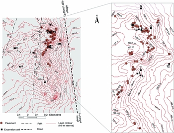
Figure 2. Topographic map (0.5m contour interval) of Birnin Lafiya site derived from a digital elevation model generated by Paul Adderley (University of Stirling) using a Leica GS09 GNSS differential survey system. The locations of excavation trenches and pavements are shown. Units 2, 3, 14, 15, 16 and 18 are at the same location as shown for Unit 10. Image by Didier N'Dah and Djafarou Abdoulaye.
In order to better understand the site and determine excavation locations, foot survey was carried out, examining site morphology and noting surface features. In particular, we undertook a systematic survey of pottery pavements visible across the site surface. A total of 73 pavements were recorded, including both well-preserved examples and those subjected to dismantling by human or natural factors. Pavements included both undecorated and decorated potsherds, and were mainly observed in the north-eastern part of the site, over an area of about 6ha (Figure 2).
Alongside the generation of a digital elevation model (DEM), geophysical survey was carried out with the primary aim of mapping the extent of the site's subsurface to assess its limits, size, nature and spatial organisation. While ground-based geophysical methods have been in common use in European and North American archaeology for decades (Gaffney & Gater Reference Gaffney and Gater2003), their potential for archaeology in other regions has remained largely under-exploited (Magnavita & Schleifer Reference Magnavita and Schleifer2004; Reindel & Wagner Reference Reindel, Wagner, Reindel and Wagner2009; Lowe Reference Lowe2012). This is changing, however, as projects increasingly integrate geophysical surveys (for South American and sub-Saharan African examples, see Osella et al. Reference Osella, de la Vega and Lascano2005; Magnavita et al. Reference Magnavita, Breunig, Ameje and Posselt2006, Reference N'Dah, Magnavita, Koté, Breunig and Idé2009; Fleisher et al. Reference Fleisher, Wynne-Jones, Steele and Welham2012; Luiz & Pereira Reference Luiz and da Silva Pereira2013). Magnetometry has become the workhorse of archaeological geophysics worldwide due to its high sampling speed (Kvamme Reference Kvamme, Maschner and Chippindale2005: 430–32), and was considered well suited to surveying such an extensive site as Birnin Lafiya. The magnetometer used was a three-channel wheeled fluxgate gradiometer with a sensitivity of 0.1nT. After clearing low vegetation, 104 survey grids of various sizes were laid out using a total station and differential GPS. A total area of 20.3ha was covered (Figure 3), revealing various details of the site.

Figure 3. Greyscale magnetic plot of Birnin Lafiya showing subsurface anomalies and proposed limits of main site.
The site's limits are clearly visible to the north, east and south, and its shape and size can be confidently inferred—archaeological remains cover a minimum of 26–27ha. The data also show the location and density of archaeological evidence, suggesting that Birnin Lafiya was a relatively dispersed settlement, with occupation remains concentrated on the edges of elevated areas facing north and east; lower-lying areas were also used, probably seasonally due to recurrent flooding. It remains unclear from the magnetic patterning whether the site formed from a continuous, long-lasting event, or from successive occupations at different places and times. This question was addressed through excavation. Interestingly, there is no indication that the site was surrounded by defensive ditches and earthen walls, as might be expected at densely populated, nucleated settlements facing external threats such as raiding and warfare, and which are extremely common throughout West Africa (Connah Reference Connah and Tracy2009).
A central component of the work was an extensive horizontal excavation (Unit 10) on the northern part of the site where survey identified the remains of mud structures. We exposed a compound extending over about 100m2, with six distinct spaces, all with pavements of potsherds or laterite (Figures 4 & 5), lying 0.2–0.4m below the surface.

Figure 4. Plan of structural complex with rammed-earth walls and potsherd and laterite pavements, excavated as Unit 10 (relationship to Unit 9, ‘Trench S9’, also indicated).

Figure 5. Partial view of Birnin Lafiya architectural complex (Unit 10) during excavation. The large paved area abutting Room 1 is clearly visible, as is Unit 9 to the bottom of the image.
The most complete spaces excavated are two circular rooms (Rooms 1 and 2) paved with potsherds laid flat, and a large paved area adjoining Room 1. Room 1 measures about 3m in diameter, with stumps of rammed-earth walls and a potsherd-covered step (Figure 6, top right). At the centre of Room 1, the burial of a child some six or seven years old (estimate based on dentition) was recovered. Its association with the building is hypothesised, although the possibility cannot be ruled out that it is intrusive from a later period. Room 2, which is 2m in diameter, features similar walls to Room 1, but is less well preserved. Pavements, wall stumps and postholes allow us to infer the structure's overall layout (Figure 4). The best preserved and most complete space is the large area adjoining Room 1 (Figure 5), which is divided into two distinct spaces, paved with potsherds or laterite and forming a partially enclosed courtyard. In this space was a beaten earth disc (Figure 6, bottom left). Embedded within a further laterite-paved area, we recovered an intact pot and a roulette-decorated ceramic cylinder (0.17m in diameter and 0.46m in height; Figure 6, bottom right). There are faint indications that a passageway linked this area to another extensive paved surface adjoining Room 2. No wall stumps were evident in this second area, but postholes suggest a mat-and-pole structure. Throughout the complex, we recovered crushed pots on floor surfaces that were seemingly associated with the building's abandonment. Excavated deposits were mostly secondary contexts—resulting from infilling of the structure following destruction—but artefacts recovered included 21 beads of stone, clay and glass.

Figure 6. Features within the Unit 10 complex. Clockwise from top left: potsherd pavement; potsherd-covered step; ceramic vessel buried in laterite floor; raised disc feature within laterite floor.
Further portions of the complex to the south remained unexcavated, while to the north and east, unknown parts have been lost to erosion. The complex is well dated through 14 radiocarbon dates ranging from 921±23 BP (OxA-29892) to 740±40 BP (Beta-305218) (Table S1 in supplementary material). Among the beads recovered, two examples of dichroic blue/yellow-green tubular glass beads of the so-called ‘Ife’ type support the likelihood of a twelfth–thirteenth-century date for the structure (Sonja Magnavita pers. comm.). The complex was almost certainly destroyed by fire; deposits immediately overlying paved surfaces contained burnt clay and large clusters of charcoal, probably roofing material. This structure was overlain by an eroded pavement and, judging by keyhole trenches, underlain by another pavement, indicating at least three phases of construction. Limited excavation of another zone some 75m away again revealed burnt walls associated with paved surfaces and indications of in situ crushed pots.
Alongside this shallow horizontal investigation, we excavated 12 trenches across the site (between 1 and 4m2 in surface area), to understand settlement evolution through time and to document Birnin Lafiya's archaeological sequence (Figure 2). Material was sieved through a 5mm mesh; organic-rich features were sieved at 2mm or floated for archaeobotanical remains. Excavations followed archaeological contexts, proceeding by 0.1m spits where necessary; within each spit, contexts were sieved and finds were bagged separately. Excavations proceeded to sterile deposits in all but a few cases.
Stratigraphic depth varied between 2 and 4m, and a suite of 27 radiocarbon dates from various contexts spans the fourth to thirteenth centuries (Table S1). The occurrence of similar deposits of comparable age ranges throughout the site represents a strong argument in favour of a continuous, long-lasting occupation. Two of the deep sequences, those of Units 9 and 11, are shown in Figures 7 and 8. These trenches were about 250m apart and they are broadly illustrative of the variety of remains encountered across the site.

Figure 7. Stratigraphy from Unit 9.

Figure 8. Stratigraphy from Unit 11.
Generally speaking, the sequence is characterised by a series of stabilisation layers and floors, collapsed architectural remains and refilled pits. In addition to the child burial in Unit 10, a further intact burial was recovered: an adult, probably female, at a depth of 3.8m in Unit 11, dated to 1560±30 BP from charcoal inside the cranium [Beta-345492] (Figure 9; Table S1). Only one other pottery pavement was encountered during excavation, at 0.81m BD (Below Datum) in Unit 11 (Context 7 on Figure 8), but compacted floor layers and laterite floors occurred frequently. Pits were very common, as indicated by geophysical and surface survey. Following some humid episodes, evidenced by fine layers of clay and sand, such pits were filled by a succession of refuse deposits, often characterised by a vivid green colour indicative of high phosphate content (Frederic Broes pers. comm.), or grey-black deposits with dense charcoal or ash. Such contexts may be interleaved with significant stratigraphic units, of a colour (light beige to yellow) and content (small potsherds mixed with burnt earth and charcoal) that are difficult to distinguish from encasing contexts. These units suggest rapid deposition from intentional backfilling or the collapse of pit walls. Finally, the uppermost levels of the pits comprise deposits that suggest stabilisation filling, with significant bioturbations.

Figure 9. Burial within Birnin Lafiya Unit 11 under excavation (left) and beads from burial (right).
This rather simple sequence is complicated by the fact that pits were dug repeatedly in the same locations over time. For example, in Unit 9 (a 2 × 2 × 4m trench), 17 pits were interlocked. The ubiquitous excavation of isolated human bone fragments and teeth testifies to a proclivity for burying the dead in close proximity to the living, and to the degree of disturbance caused by human activity (Scott MacEachern pers. comm.).
In terms of material culture, a wide range of pottery was recovered (Figure 10), consisting principally of roulette-decorated (predominantly folded-strip roulette) coarse wares and highly burnished wares, some of which were incised. Our significant programme of post-excavation vessel reconstruction has reconstituted large coarse-ware items, probably liquid containers or storage vessels, and burnished bowls of various sizes, presumably for cooking and serving food and drink.

Figure 10. Characteristic roulette-decorated and burnished pottery from Birnin Lafiya. From top right, clockwise: Unit 9, context 13; Unit 6, Square A, Context 3; Unit 9, Context 12; Unit 11, Context 15; and Unit 10, Context 8.
Due to extensive sieving, the recovery of small finds was good. A wide range of beads was retrieved. These were mainly various stone beads, including 25 red beads from the Unit 11 burial (Figure 9), some made of carnelian or of the local crypto-crystalline silica called lantana, known historically as a major regional trade item (O'Hear Reference O'Hear1986). Less-diagnostic items include shell and bone beads, of which 64 intact and fragmentary examples were recovered from the Unit 11 burial, perhaps indicative of access to wide-ranging resource networks. We also recovered glass beads, iron bracelets/anklets and spear and harpoon points. Small ceramic figurines, mostly depicting animals but with some anthropomorphic representation, were also common.
Extensive dry and wet sieving produced rich data regarding past diets. Unsurprisingly, fish were strongly represented—mainly floodplain species—as well as a diverse suite of wild mammals, and relatively rare domesticates (Veerle Linseele pers. comm.). Pearl millet (Pennisetum glaucum), African rice (Oryza glaberrima) and cotton (Gossypium) are all present (Dorian Fuller pers. comm.), and charcoal analysis indicates the presence of agroforestry parklands dominated by shea (Vitellaria paradoxa) and other useful fruit trees, and the regular exploitation of riverside vegetation (Barbara Eichhorn pers. comm.). Altogether, these data point to a slightly wetter environment than the present.
Wider significance
Birnin Lafiya provides a significant contribution to the growing archaeological picture of the first and second millennium AD landscape in West Africa. On present evidence, occupation was seemingly established on a pre-existing elevation on the flood plain, but our excavations have so far only recovered shreds of original palaeosoil in Unit 9. It is likely that the natural mound was initially used for low-intensity settlement, probably before the fourth century AD. The mound was thereafter more densely occupied: stratigraphy from most trenches attested to intensive occupation. Comparison of Figures 7 and 8 shows two long stratigraphic sequences, from Units 9 and 11 respectively, that appear essentially similar in nature and date despite being from quite different parts of the mound (Figure 2), supporting the case for a contemporaneous and long-standing occupation of several areas. Indeed, there seems to have been some stability in the settlement grid. In Unit 9, near the edge of the excavated architectural complex, an intricate series of pits is visible in the east section, a situation replicated in Unit 4, some 20m to the east. In contrast, the opposite profile, which cuts through the complex's pottery paved area reveals a succession of stabilisation layers, a situation paralleled in Unit 1, 20m to the north-west. It seems then, that areas for house building and for pit-digging (for refuse disposal or clay extraction) may have been spatially separated throughout the site's occupation. Although demarcated, these separate areas may have been contiguous; geophysical data suggest that pits were most probably dug adjacent to living areas or houses.
Our work represents the only intensive study of a large settlement mound within a 400km area. Such large, deeply stratified sites are, however, known elsewhere in West Africa (see Figure 1 for site locations). The settlement site of Sadia, in Mali, consists of five anthropogenic mounds over about 3ha and archaeological deposits spanning the eighth to the late thirteenth centuries AD (Huysecom et al. Reference Huysecom, Ozainne, Jeanbourquin, Mayor, Canetti, Loukou, Chaix, Eichhorn, Lespez, Le Drézen and Guindo2015). Remains of buildings dating to the final phase (mid eleventh to late thirteenth centuries) were found amid a densely packed arrangement of features such as post-holes, pits, hearths, hardened occupation floors and burials, providing insight into spatial organisation. At Kirikongo, Burkina Faso, at roughly the same latitude as Birnin Lafiya, excavations at a cluster of 13 mounds spanning AD 100–1300 identified a range of structures (Dueppen Reference Dueppen2012). At the mound complex of Oursi, also in Burkina Faso, excavations have revealed spectacularly preserved mud structures dating to the ninth and tenth centuries AD, with individual circular rooms and associated courtyards and linking spaces, and evidence for sudden and violent destruction. Survey identified at least 13 compounds, suggested by burnt mud-brick debris (Petit et al. Reference Petit, von Czerniewicz and Pelzer2011).
Within West Africa, mound sites are most often discussed in relation to the important, albeit often later, polities from farther north in the Sahel, described by North African and Middle Eastern writers. The Dendi region features in no written sources, being too far south for medieval authors, and interpretations therefore rely upon archaeology alone. The intensive exploitation of riverine resources and cultivation of important domesticates (including African rice) demonstrates the site's articulation with its immediate landscape. The question of interregional, and specifically riverine, trade is important here. There has long been a desire to put points on the map between known early trade locations situated on the eastern arc of the Niger River, such as Gao and Igbo-Ukwu. Our work in Dendi fulfils this goal. A range of finds are significant here. For instance, lantana stone is known historically to have been a major trade item, quarried and delivered downriver by Hausa traders (O'Hear Reference O'Hear1986), while the archaeobotanical recovery of cotton may relate to trade in textiles. Definite long-distance finds from Birnin Lafiya include marine shells, for example a bivalve from Unit 13 (Veerle Linseele pers. comm.). Overall, however, there is a lack of significant evidence for external trade goods, perhaps because few intact burial contexts were recovered. Certainly a number of studies within the wider region have proposed that highly visible signs of status differences may be absent, or that comparatively compact settlements emerged as centres of city-states rather than large, ‘socially complex’ territorial states (see for example McIntosh Reference McIntosh1995; Dueppen Reference Dueppen2012). Whether Birnin Lafiya can be identified as a past power centre will be partly clarified by our ongoing analysis of survey data to elicit settlement patterning.
Among the evidence recovered, the pottery pavements are compelling features. Widely known within West Africa, the best-known examples are from Ife, made of potsherds set on edge, often in herringbone patterns (Willett Reference Willett1959: pl. VIIIa; Garlake Reference Garlake1974: figs 3 & 4 and pl. XXXVI; Eyo Reference Eyo1974: fig. 3 & pl. XXVII). In a survey of West African ethnographic and archaeological occurrences, Nzewunwa (Reference Nzewunwa1989) notes that pavements served various uses: aesthetic value, religious practice, or to consolidate floors and prolong their life. Potsherd pavements occur widely within Dendi. In addition to the Birnin Lafiya examples, we recovered instances with associated dates from Pekinga (60km north-west of Birnin Lafiya; 610±30 BP [Beta-321057]), Tin Tin Kanza (20km north-north-west; 920±30 BP [Beta-348774] and 1010±30 BP [Beta 345502]), and Alibori Site 2 (4km west; 730±30 BP [Beta-378257]) (Figure 1). At Tin Tin Kanza, seven superimposed pavements were recovered over a depth of some 0.5m, in some instances associated with crushed pots (Champion & Haour Reference Haour2013). They appear absent inland from Dendi and on the opposite shore of the Niger River (N'Dah Reference N'Dah, Magnavita, Koté, Breunig and Idé2009; Boubé Gado pers. comm.), but significant examples are known about 200km downstream (Nzewunwa Reference Nzewunwa1989; Haour Reference Haour2013).
Birnin Lafiya is exceptional not just in providing new and well-preserved examples of pottery pavements within West Africa, but also in combining these with standing structural remains. Early evidence for mud architecture in West Africa is limited, but includes the well-known examples of Jenné-jeno (McIntosh Reference McIntosh1995) and Dia (Bedaux et al. Reference Bedaux, Polet, Sanogo and Schmidt2005), as well as the more recently published cases at Sadia (Huysecom et al. Reference Huysecom, Ozainne, Jeanbourquin, Mayor, Canetti, Loukou, Chaix, Eichhorn, Lespez, Le Drézen and Guindo2015), Kirikongo (Dueppen Reference Dueppen2012) and Oursi (Petit et al. Reference Petit, von Czerniewicz and Pelzer2011), alluded to above. At Sadia, a series of circular and straight walls of sun-dried mud-bricks indicate the location and shape of former circular buildings and the limits of domestic spaces. With inner diameters of about 1.5m, most of the better-preserved structures probably did not serve as living spaces, but rather fulfilled other functions. Less well-preserved circular walls exist, hinting at larger structures that may be interpreted as former houses (Huysecom et al. Reference Huysecom, Ozainne, Jeanbourquin, Mayor, Canetti, Loukou, Chaix, Eichhorn, Lespez, Le Drézen and Guindo2015: fig. 5). Sadia offers a striking parallel to the structural evidence found at Birnin Lafiya, involving a dense honeycomb pattern of construction, through which a number of circular buildings are linked to each other by straight or curved walls forming small courtyards (Huysecom et al. Reference Huysecom, Ozainne, Jeanbourquin, Mayor, Canetti, Loukou, Chaix, Eichhorn, Lespez, Le Drézen and Guindo2015: fig. 5). At Kirikongo, floors of crushed laterite or a combination of clay and laterite, as well as walls of sun-dried bricks or puddled mud, were recovered, including 2–2.5m-diameter structures interpreted as huts, some of which include a bench or large pottery vessels, resembling the features recovered at Birnin Lafiya (Dueppen Reference Dueppen2012). Finally, close parallels to Birnin Lafiya also exist at Oursi (Petit et al. Reference Petit, von Czerniewicz and Pelzer2011), where 30 or so rooms of 3.5–4m diameter, courtyards and other spaces were identified, as well as clusters of crushed pots. Architectural remains of sun-dried mud-bricks with mud-plaster coating were preserved to a height of 0.5–1.5m. Floors were made of trampled earth with a mud ‘floor plaster’. A thick layer of sand was then deposited over this, and there was clear evidence for a supporting roof, including pillars and roof timbers. Importantly, however, pottery pavements are not reported at Sadia, Kirikongo or Oursi.
The complex uncovered in Unit 10 at Birnin Lafiya was probably a domestic building; the arrangement of circular rooms associated with a larger compound is certainly common ethnographically (Denyer Reference Denyer1978; Dmochowski Reference Dmochowski1990). Our wider surveys and excavations show that the building is a well-preserved example of a type that is not uncommon throughout the settlement. Whether the general confinement of pavements and associated structures to the eastern part of the site relates to chronological or social factors, or to post-depositional issues is a matter we are exploring. The Birnin Lafiya evidence represents a significant contribution to the study of early West African architecture, demonstrating well-preserved mud remains associated with intact potsherd pavements over a large area.
Conclusion
The archaeology of Sahelian West Africa is increasingly able to contribute to global debates on social complexity. Within this, the Niger River valley has played a key role, being fundamental to the development of some of West Africa's most important cultural groups, political formations and interregional connections. Birnin Lafiya and its surrounding area may now be added to the growing body of data from this region, documenting occupation along the eastern portion of the Niger River within the first and early second millennia AD. These data arise from a field that has traditionally been neglected, both chronologically and geographically, and these results therefore considerably enhance our knowledge of the archaeological landscape. As we begin to fill in the blanks on the map between the Niger bend and the forest to the south, we are inevitably confronted by new interpretative challenges, parallel to those taken up by scholars working closer to the Atlantic coast who have grappled with the enigma of places such as Igbo-Ukwu since the 1970s (Chouin Reference Chouin2013). The large and complex site of Birnin Lafiya, intensively occupied over a period of nearly 1000 years, ultimately provides new perspectives for the global representation of themes of social organisation, trade and craft specialisation. It also represents a wider, under-studied landscape of large settlement mounds, and provides a window into the under-explored cultures that gave rise to them.
Acknowledgements
The research leading to these results has received funding from the European Research Council under the European Union's Seventh Framework Programme (FP/2007-2013) / ERC Grant Agreement 263747 to Anne Haour. Twelve of the radiocarbon dates reported here were funded by the NERC-AHRC National Radiocarbon Facility (NRCF), awarded in 2013 to Anne Haour and Sam Nixon. We thank the populations and authorities of Dendi for their support and welcome, and the team members for their work on the site—particularly Mardjoua Barpougouni, Nestor Labiyi, Richard Lee, Frank N'Po Takpara and Jennifer Wexler. The research also benefited from constructive discussions with Olivier Gosselain, Université libre de Bruxelles.


