


Introduction
The diverse trajectories of socio-economic change during the Pleistocene–Holocene transition form a key topic in the study of human evolutionary history (Childe Reference Childe1936; Sauer Reference Sauer1952; Binford & Binford Reference Binford and Binford1968; Flannery Reference Flannery, Ucko, Tringham and Dimbleby1973; Bar-Yosef & Belfer-Cohen Reference Bar-Yosef and Belfer-Cohen1989; Kelly Reference Kelly1992). Well-known examples include developments in the hunting-and-gathering strategies in South-east Europe (Straus Reference Straus2018) and the transition from hunting, gathering and pre-domestication cultivation to cereal cultivation in the Levant (Rosen & Rivera-Collazo Reference Rosen and Rivera-Collazo2012). In East Asia, the Palaeolithic–Neolithic transition is characterised not by the adoption of settled village life based on farming, but by the transformation of hunter-gatherer lifestyles from mobile to sedentary (Kuzmin Reference Kuzmin2013; Gibbs & Jordan Reference Gibbs and Jordan2016; Gibbs et al. Reference Gibbs, Isaksson, Craig, Lucquin, Grishchenko, Farrell, Thompson, Kato, Vasilevski and Jordan2017), although some studies in south China have claimed that the occurrence of wild rice and semi-domesticated or domesticated rice phytoliths associated with early pottery pre-dates c. 10 000 cal BP (Zhao Reference Zhao1998; Yuan Reference Yuan and Yasuda2002). These examples suggest that regional differences in climatic conditions and ecological settings may have led to varied socio-economic trajectories across East Asia (Sato & Natsuki Reference Sato and Natsuki2017).
Past research in the Japanese archipelago has suggested that hunter-gatherer lifestyles changed in response to climatic amelioration during the transition from the Late Glacial to the Early Holocene, which brought warmer and wetter conditions and stabilised terrestrial and marine food resources (Kondo Reference Kondo1965; Watanabe Reference Watanabe1968; Kobayashi Reference Kobayashi1974). The studies also indicated that the first pottery appeared during this period in order to exploit and process more efficiently these newly available resources. The results of recent radiocarbon dating, however, question many of the proposed links between climatic amelioration, the development of pottery and the adoption of a sedentary lifestyle, which appear to be based on erroneous radiometric dates and palaeoenvironmental data (Taniguchi & Kawaguchi Reference Taniguchi and Kawaguchi2001; Keally et al. Reference Keally, Taniguchi and Kuzmin2003).
Several additional hypotheses concerning the transition to sedentism in Japan remain to be tested. In particular, Sato (Reference Sato1992) claimed that the intensification of Late Pleistocene inland fishing led to seasonal settling down at specific locations, which, in turn, led to more permanent sedentism. The subsequent confirmation of the existence of ‘ice-age’ (Late Pleistocene) pottery in Japan (Taniguchi & Kawaguchi Reference Taniguchi and Kawaguchi2001; Keally et al. Reference Keally, Taniguchi and Kuzmin2003) has increased the credibility of this hypothesis as the most convincing explanation for the development of sedentism. This hypothesis is also supported by the recent results of lipid analysis, which strengthens the association of early pottery with the processing of aquatic resources (Lucquin et al. Reference Lucquin, Robson, Eley and Craig2018).
This article re-evaluates the past hypothesis of the origins of sedentism by reviewing the history of research and integrating recent archaeological data, focusing particularly on newly obtained radiocarbon dates and palaeoenvironmental data from the Maedakochi site—the most important archaeological site in Japan for understanding the Late Pleistocene–Early Holocene transition to sedentism.
Research history
Early archaeological studies concluded that the oldest pottery in Japan, of the Jomon tradition, diffused from Mainland Asia c. 4500 BP (Yamanouchi Reference Yamanouchi1969). Subsequently, however, the radiocarbon dating of material from the Natsushima shell mound revealed that the earliest Jomon pottery dates back to 9000 cal BP (Crane & Griffin Reference Crane and Griffin1960; Sugihara Reference Sugihara1962). As a result of these new data, the hypothesis was developed that Holocene climatic amelioration caused the change in lifestyle from one of mobile hunting and gathering to a sedentary one, as well as the development of pottery for more efficient exploitation of resources in these new environments (Kondo Reference Kondo1965; Watanabe Reference Watanabe1968; Kobayashi Reference Kobayashi1974). Additional radiocarbon dates from the Odai-Yamamoto site in the Aomori Prefecture, however, further pushed back the appearance of the earliest pottery in Japan to between 16 500 and 15 000 cal BP—at the end of the Last Glacial (Taniguchi & Kawaguchi Reference Taniguchi and Kawaguchi2001; Keally et al. Reference Keally, Taniguchi and Kuzmin2003)—thereby challenging the link between pottery and climatic amelioration at the heart of the previous hypothesis.
Using previously published radiocarbon dates, Morisaki and Natsuki (Reference Morisaki and Natsuki2017) analysed the diachronic distribution of lithic assemblages, early pottery and pit-houses across the Japanese archipelago, demonstrating that small amounts of ‘ice-age’ pottery were used by mobile hunter-gatherers in various regions beyond the warmer parts of the islands, including northern and eastern Japan, and the coastal region along the Japan Sea. As the climate warmed during the early Late Glacial, settlements with pit-houses and evidence for arrowhead manufacture and the consistent use of pottery appeared—predominantly in the Pacific coastal regions of south-western Japan (also see Taniguchi Reference Taniguchi2005). Hence, climatic amelioration did not induce the ‘initial’ appearance of pottery, but, rather, the ‘development’ of sedentary lifestyles that utilised ceramics (Kajiwara Reference Kajiwara1998; Imamura Reference Imamura1999; Taniguchi Reference Taniguchi2005; Morisaki & Natsuki Reference Morisaki and Natsuki2017).
Recently, the changes leading to sedentism have been discussed with regard to the functions of early pottery. Kunikita et al. (Reference Kunikita, Shevkomud, Yoshida, Onuki, Yamahara and Matsuzaki2013) have employed isotope analysis of charred residues to confirm that the oldest pottery in Hokkaido was used for the processing of aquatic resources. Through the extensive application of lipid analysis to early pottery in the Japanese archipelago, Craig et al. (Reference Craig2013) and Lucquin et al. (Reference Lucquin, Robson, Eley and Craig2018) have suggested that the production of these ceramics was associated with the intensified exploitation of aquatic resources and increasing sedentism at the beginning of the Holocene. To some degree, this scenario parallels Sato's (Reference Sato1992) hypothesis. Building on previous research concerning the significance of fishing in the appearance of sedentism (Watanabe Reference Watanabe1972; Nishida Reference Nishida1984; Binford Reference Binford1990), Sato (Reference Sato1992) proposed that the intensification of inland fishing from the Terminal Palaeolithic to the beginning of the Jomon period may have induced a seasonal sedentary lifestyle and broader spectrum resource exploitation.
While aforementioned recent research on the function of the earliest pottery therefore seems to support Sato's (Reference Sato1992) hypothesis about inland fishing, it should be re-examined in the light of new archaeological finds from the Maedakochi site in Tokyo. Maedakochi is ideal for the re-evaluation of Sato's hypothesis, as it has yielded numerous archaeological assemblages, including lithics, early pottery, charcoal and faunal remains—including abundant fish bones. Furthermore, for this article, we have acquired new AMS radiocarbon dates (unpublished material from the site was previously dated in 1983 using the β-ray counting method) and have re-analysed the extant palaeobotanical data.
Environmental conditions during the Pleistocene–Holocene transition
In East Asia, the time period from the Last Glacial Maximum (30–19ka cal BP (Lambeck & Chappell Reference Lambeck and Chappell2001)) to the Post Glacial is divided into four chronozones (Nakazawa et al. Reference Nakazawa, Iwase, Akai and Izuho2011; Kudo Reference Kudo2012; Morisaki et al. Reference Morisaki, Izuho, Terry and Sato2015, Reference Morisaki, Izuho, Sato, Robinson and Sellet2018): the stage prior to the Late Glacial warm period; the Late Glacial warm period (c. 14 700–12 800 cal BP); the Late Glacial cold period (c. 12 800–11 500 cal BP); and the Post Glacial (Wang et al. Reference Wang, Cheng, Edwards, An, Wu, Shen and Dorale2001). These chronozones differ from those in Northern Europe (Stuiver et al. Reference Stuiver, Grootes and Braziunas1995), and are based on recent palaeoclimatic studies of cave stalagmites in China (e.g. Hulu Cave) and varved lacustrine sediments in Japan (e.g. Lake Suigetsu); as such, they are considered to reflect more accurately the regional climatic conditions in East Asia. Cave stalagmites in Hulu Cave have also revealed millennium-scale fluctuations in the intensity of the Asian monsoon, which correspond with climatic fluctuations recorded in the Greenland ice cores (Figure 1) (Wang et al. Reference Wang, Cheng, Edwards, An, Wu, Shen and Dorale2001; Yuan et al. Reference Yuan2004). Although some differences exist between the oxygen isotope records of Northern Europe and those of East Asia, at least three relatively distinct synchronic changes in oxygen isotope signatures can be observed between the two regions (Wang et al. Reference Wang, Cheng, Edwards, An, Wu, Shen and Dorale2001): at the onset of the Late Glacial warm period, and during both the Late Glacial cold period and the Post Glacial.

Figure 1. Oxygen isotope record and chronozones in: a) Northern Europe (from Stuiver et al. Reference Stuiver, Grootes and Braziunas1995: 348); b) in East Asia (China) (from Yuan et al. Reference Yuan2004: 576).
During the Last Glacial Maximum, the Japanese archipelago and surrounding region was comprised predominantly of two distinct landmasses: the Palaeo-Sakhalin-Hokkaido-Kurile peninsula (Palaeo-SHK) and Palaeo-Honshu Island (Figure 2). A gradual rise in sea level occurred from the Late Glacial warm period to the wet climate of the Post Glacial (Igarashi & Zharov Reference Igarashi and Zharov2011; Moriwaki et al. Reference Moriwaki, Matsushima, Sugihara, Ohira, Oki, Masubuchi and Tsurumaki2015), separating the landmasses into their four present forms: Hokkaido, Honshu, Shikoku and Kyushu.

Figure 2. Reconstructed topography and vegetation zones of the Japanese archipelago and surrounding regions during the Last Glacial Maximum (after Iwase et al. Reference Iwase, Hhashizume, Izuho, Takahashi and Sato2012: 116).
During the Last Glacial Maximum, Paleo-SHK was covered with open larch (Larix) forest and grassland (Igarashi & Zharov Reference Igarashi and Zharov2011; Takahara & Hayashi Reference Takahara, Hayashi, Kaifu, Izuho, Goebel and Sato2015). North-eastern Palaeo-Honshu was covered with evergreen coniferous forest, while temperate coniferous forests dominated in the south-west. The Kanto region, where the Maedakochi site is located, was on the eastern edge of south-western Palaeo-Honshu. During the Late Glacial, the inflow of the warm Tsushima current into the Japan Sea resulted in increased precipitation, and the coniferous forests of Palaeo-Honshu gave way to temperate deciduous forest except in northernmost Paleo-Honshu where evergreen coniferous forest still dominated. Palaeo-SHK was gradually separated into several landmasses; of these, Hokkaido was eventually covered by evergreen coniferous forests similar to north-eastern Palaeo-Honshu. Data on the forest vegetation of south-western Palaeo-Honshu, including the Kanto region, indicate a warmer climate than that of north-eastern Palaeo-Honshu, although broadleaf evergreen forests covered only the Pacific coastal region until the onset of the Holocene (Takahara & Hayashi Reference Takahara, Hayashi, Kaifu, Izuho, Goebel and Sato2015).
Re-examining the Maedakochi site
Site-formation process and cultural components
The Maedakochi site is located in Akiruno City, Tokyo, and is currently situated on a lower terrace, although the place occupied by hunter-gatherers was dry riverbank, close to the confluence of the Tamagawa and Akikawa Rivers. Today, the site is 10m higher than the river levels and is surrounded by residential areas (Figure 2). From 1976–1984, a rescue excavation in advance of land development uncovered an area of approximately 36 590m2, revealing material culture possibly belonging to the Terminal Palaeolithic to Incipient Jomon (component I), along with evidence of later periods (Hatori Reference Hatori1979; Tokyo Metropolitan Archaeology Center 1992). Component I was recovered mainly from the north-western part of this site (location 5; Figure 3A).
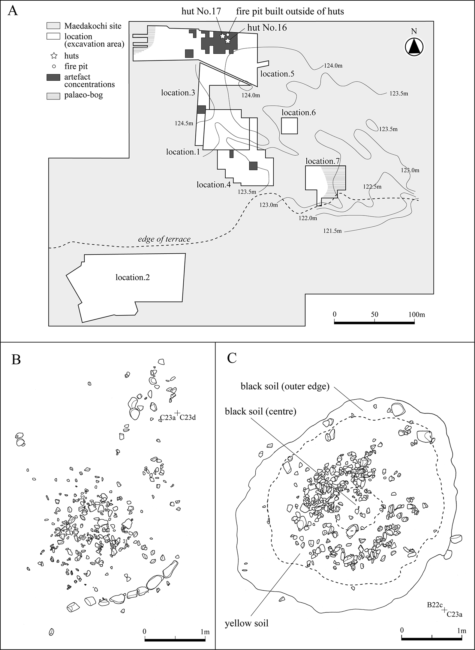
Figure 3. The Maedakochi site: excavation areas (A) and huts 16 (B) and 17 (C) (modified from Tokyo Metropolitan Board of Education 2002).
Six Late Quaternary stratigraphic units extending to a depth of more than 1m were identified at location 5 (Figure 4). At the base of the profile, layer VI, a bed of the lower terrace, comprised thick, alternating layers of alluvial gravels (VIa) and sands (VIb). Layer VI was overlain by yellow fluvial-flood sand (layer V) and, successively, by poorly sorted dark, sandy gravel (layer III). Layer V was not pedogenic (not related to soil-formation processes) and was soon overlain by the deposition of layer III. Layer III contained middle Jomon artefacts (c. 5000–4000 BP). Layer I was modern plough soil. While layers II and IV (dark brown sandy soil) were also recognised at this site, they did not appear in close approximation to component I.

Figure 4. Stratigraphic profile of location 5 at the Maedakochi site (figure by N. Oda & K. Morisaki).
Component I, at 0.4–0.5m below the surface, within layer V and the top of layer VI, dates to the Palaeolithic–Jomon transition. This occupation is represented by six large concentrations of lithic material, two of which were found in locations 1 and 4, to the south of location 5. Evidence for two ‘huts’ (16–17) was also uncovered in the top of layer V in location 5. Hunter-gatherers first occupied this area immediately following the deposition of layer VI. As the site was situated on the riverbanks at the confluence of the Tamagawa and Akikawa Rivers, the formation of component I was only interrupted by flooding (layer V), which was followed again by subsequent reoccupation and the building of two huts.
Hut 16 yielded an arc-shaped alignment of pebbles and a concentration of 200 fire-cracked pebbles, but lacked a hearth or associated pits. Hut 16 was possibly 3.3m in diameter, based on the available evidence. Discovered close to hut 16, hut 17 had a sub-circular plan measuring approximately 4.2m (long axis) by 3.1m (short axis) (Figures 3B & 5). The subterranean hut's floor was approximately 0.1m below the ground's surface, with a hearth located at its centre (Figure 3C).

Figure 5. Hut 17 during excavation (Tokyo Metropolitan Board of Education 2002).
Large quantities of lithic tools and debitage, a few pottery fragments and faunal remains were unearthed inside and around both huts (Figure 6). Most lithics were produced using manufacturing bifacial points. The lithic assemblage comprises 2303 bifacial points, 72 bifaces, 169 side scrapers, 97 notched scrapers, 70 end scrapers, 3 drills, two axes, 11 pebble tools, 2 hammer stones, 1 anvil stone, and numerous debitage products, including cores, flakes and chips (Tokyo Metropolitan Board of Education 2002). The tools are mostly of local chert, hornfels and tuff. The pottery fragments are thought to represent two vessels. One of them, from hut 17, is an undecorated deep bowl; its clay fabric is tempered using plant fibres. The other vessel, recovered outside of hut 17, is also an undecorated bowl; its fabric does not contain organic fibres.

Figure 6. Lithic tools from the Maedakochi site: 1–7) bifacial point; 8–11) notched scraper; 12) side scraper; 13–14) drill; 15) end scraper; 16) axe; 17) pottery fragments (modified from Tokyo Metropolitan Board of Education 2002).
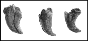
Unexpectedly, the burnt soil from hut 17 yielded thousands of faunal remains. While most of these represent salmonid fish (Figure 7), bear and other mammals are also present (Kato Reference Kato1985; Tokyo Metropolitan Archaeology Center 1992). No comparable archaeological site has been discovered anywhere else in Japan.

Figure 7. Examples of salmonid fish teeth (photograph by T. Yamazaki).
AMS dating
Since 2017, we have conducted a wide-ranging re-investigation of the archaeological records from the Maedakochi site in order to obtain clearer insight into hunter-gatherer behaviour from the Terminal Palaeolithic to the Jomon period. Here, we present the results of new AMS dating and the identification of wood charcoal species to confirm the chronology of the site.
All of the analysed samples derive from hut 17. These samples had all been stored since excavation in 1981–1982, in appropriate conditions at the Tokyo Metropolitan Archaeology Center. From three boxes containing 50–100 pieces of wood charcoal with stratigraphic location data, we chose 10 samples. Four of these samples derive from the black soil identified near the outer edge of the hut, four from the yellow soil spread within it, and two from the black soil near the hearth area of the centre of the hut (Figure 3C).
After preliminary checks to ensure their suitability for wood-species identification (see below), five of the particularly well-preserved samples were divided into two pieces each for radiocarbon dating. Sample preparation for radiocarbon dating was conducted following the methods of Yoshida et al. (Reference Yoshida, Ohmichi, Kinose, Iijima, Oono, Abe, Miyazaki and Matsuzaki2004). To remove the contaminants, samples were subjected to an acid-alkali-acid (AAA) pre-treatment at 80°C. The process of oxidation and reduction of the graphite sample matched that described by Yoshida and Miyazaki (Reference Yoshida, Miyazaki and Nishiaki2001). The measurements were taken using the compact AMS at the University Museum of the University of Tokyo (Table 1) and the results calibrated using OxCal v4.3.2 (1σ confidence level) (Bronk Ramsey Reference Bronk Ramsey2013; Bronk Ramsey & Lee Reference Bronk Ramsey and Lee2013). The five samples from hut 17 date to 13 095–12 865 BP (c. 15 800–15 200 cal BP).
Table 1. Results of radiocarbon dating of charcoals from hut 17. Dates calibrated (1σ confidence level) using OxCal v4.3.2 (Bronk Ramsey Reference Bronk Ramsey2013; Bronk Ramsey & Lee Reference Bronk Ramsey and Lee2013).

Wood-species identification
For wood-species identification, the 10 samples were split using a cutter to expose the three sections—cross, tangential and radial—before being fixed on a bronze stand with double-sided adhesive tape, treated with silver paste and, finally, coated with gold. Observation and identification were performed using a scanning electron microscope (SEM). The results reveal eight taxonomic groups, including conifers, such as Abies, Larix and Picea, broad-leaved trees, such as Prunus s.l., Ulmus, Betula and Phellodendron amurense Rupr. and an unknown diffuse-porous wood (Table 2 & Figure 8).

Figure 8. SEM photographs of carbonised wood samples: 1a–c) Abies (No. 2 in Table 2); 2a–c) Larix (No. 5 in Table 2); 3a–c) Picea or Larix (No. 8 in Table 2); 4a–c) Prunus s. l (No. 7 in Table 2); 5a–5) Ulmus (No. 10 in Table 2); 6a–6c) Betula (No. 1 in Table 2); 7a–c) Phellodendron amurense Rupr (No. 4 in Table 2); 8a–c) unknown diffuse-porous wood (No. 6 in Table 2); a = cross section; b = tangential section; c = radial section (scale: 0.1mm) (figure by Y. Kuronuma & Y. Sasaki).
Table 2. Results of wood-species identification of charcoals from hut 17

Among the carbonised wood fragments excavated from hut 17, analysed samples included sub-arctic coniferous trees, such as Abies, Larix and Picea, and deciduous broad-leaved trees such as Prunus s.l., Ulmus, Betula and Phellodendron amurense Rupr. growing in a cold temperature zone. Although other samples preliminarily examined by stereomicroscope included diffuse-porous wood and coniferous wood, ring-porous wood specimens of Fagaceae, such as Quercus and Castanea, could not be confirmed.
Discussion
What is the significance of the results of our re-examination of samples from the Maedakochi site in light of the updated chronology presented here? Figure 9 plots the number of archaeological sites with pottery for every thousand years from 17 000–10 000 BP, and shows that the emergence of pottery pre-dates the Late Glacial (Figure 9; Morisaki & Natsuki Reference Morisaki and Natsuki2017). The Maedakochi site has yielded material covering a narrower date range compared with other sites of the pre-Late Glacial warm period in Japan.

Figure 9. Archaeological components and site frequency before and during the Late Glacial: 1–5) Odai-yamamoto I; 6–10) Gotenyama 2N; 11–20) Taisho 3; 21–28) Onigano; 29–34) Kuzuharazawa IV; 35–39: Oshikakubo. LGw: Late Glacial warm period, LGc: Late Glacial cold period (figure by N. Oda & K. Morisaki).
Wood-species identification for the Maedakochi site suggests the local dominance of tree species with a preference for cold temperatures, supporting the results of the AMS radiocarbon dating. The Maedakochi site cannot be attributed to the Late Glacial warm period because Palaeo-Honshu Island saw a decrease in sub-arctic coniferous trees, with Quercus sect. Prinus (which does not seem to be present at the site) becoming dominant during the Late Glacial warm period (Kudo Reference Kudo2012). Hence, the emergence of pottery—at least in this locality—cannot be explained simply by Post Glacial climatic amelioration.
Immediately prior to the Late Glacial warm period, hunter-gatherers settled at the Maedakochi site for a short time; they were engaged in distinctive subsistence activities that required the intensive manufacture of lithics and the construction of small huts. Abundant faunal remains recovered with burnt soil within hut 17 strongly imply that this subsistence activity was based around salmonid exploitation, and it appears that pottery was used in conjunction with this practice. Thus, the emergence of pottery at this site seems to be closely linked with this intensive inland fishing activity.
It has even been noted that, immediately prior to the Late Glacial warm period, many hunter-gatherer sites moved down to the river bank from a higher river terrace or hill (Sato Reference Sato2002; Sawada Reference Sawada2017). The Araya site in Niigata Prefecture (Tohoku University Department of Archaeology and Kawaguchi Town Board of Education 2003), at which a wedge-shaped microblade core industry was practised c. 17 000–16 000 cal BP, for example, is located in a similar topographic position to the Maedakochi site—at the confluence of two rivers. Several archaeological sites in Tsunan Town in Niigata Prefecture (Sato Reference Sato2002), which include a cluster of Incipient Jomon sites, were also relocated from higher ground down to the natural levees of the Shinano River immediately prior to the Late Glacial. Site locations similar to that of the Maedakochi site have been recognised in other regions, including the Odai-Yamamoto site in Aomori Prefecture and the Taisho 3 site in Hokkaido (Odai-Yamamoto I Site Excavation Team 1999; Obihiro City Board of Education 2006). These changing site locations and the construction of small huts seem to relate to the intensification of inland fishing in this period.
After the onset of Late Glacial warming, pit-house settlements appeared across the Pacific coastal regions of south-western Japan (Morisaki & Natsuki Reference Morisaki and Natsuki2017). The Maedakochi site seems to have been a precursor of these later sites, although, with evidence of only two huts, Maedakochi demonstrates a comparatively lower degree of sedentism. The process of sedentism was therefore not triggered by Late Glacial climatic warming; instead, it was related to the intensification of inland fishing, which created the conditions necessary for sedentary life.
Conclusions
This article has reconsidered the processes that triggered sedentism through a re-evaluation of the chronology and palaeoenvironment from the Maedakochi site. To this end, it has also combined the results of new AMS dating and wood-species identification with this site's broader archaeological context.
Chronologically, the site clearly dates to immediately before the Late Glacial warming, suggesting that climatic amelioration cannot explain the emergence of dwelling features, or ‘huts’, and the earliest pottery. Instead, we suggest that intensified inland fishing in cold environments, prior to the Late Glacial warm period, led to sedentism and, probably, to the development of pottery—a hypothesis originally proposed by Sato (Reference Sato1992). Recent progress in isotope and organic residue analyses supports this archaeological evidence (Craig et al. Reference Craig2013; Kunikita et al. Reference Kunikita, Shevkomud, Yoshida, Onuki, Yamahara and Matsuzaki2013; Lucquin et al. Reference Lucquin, Robson, Eley and Craig2018). The results of our research offer, for the first time, direct evidence that indicates a clear correlation between the appearance of dwelling features, the development of pottery and inland fishing immediately prior to the Late Glacial warm period. In central Japan, this combination can be taken to indicate the triggering of sedentism. This has important implications for research into the beginnings of sedentary life in other areas with similar environmental conditions, such as regions in the Russian Far East. Conversely, the extent of aquatic resource exploitation at Incipient Jomon sites in the western part of south-western Japan remains uncertain, suggesting that diverse trajectories towards sedentism may be observed even within the Japanese archipelago.
Here we have focused on the chronological and palaeoenvironmental evidence, but in the future, we plan to re-evaluate the intra-site spatial organisation of the Maedakochi site. This will include analyses of the lithic technology (more than 200 000 lithic tools and pieces of debitage) and faunal remains in order to understand better site-formation processes and the wider Palaeolithic–Neolithic cultural trajectory of the Japanese archipelago.
Acknowledgements
We thank Toshiyuki Ito and Masahito Aihara at the Tokyo Metropolitan Board of Education, and Shi'ya Nagasako at the Tokyo Metropolitan Archaeology Center, for allowing us to examine the archaeological materials from the Maedakochi site, and Shuichi Noshiro at the Center for Obsidian and Lithic Studies, Meiji University, for his critical appraisal of the manuscript. We also thank the staff of the Radiocarbon Dating Laboratory, University Museum, University of Tokyo. This work was supported partially by the Grant-in-Aid for Scientific Research of the Japan Society of the Promotion of Science (JSPS) (subject 15H03261).


