


Introduction
Research on Rome in the Bronze Age has long suffered from the inaccessibility of archaeological layers trapped beneath three millennia of densely accumulated urban deposits, which have either obscured or eradicated the material traces of Rome's earliest inhabitants. These complications have largely relegated the study of prehistoric Rome to hypothetical reconstructions drawn from a problematic written record, or based upon tentative comparisons with contemporary settlements in central Italy (e.g. Peruzzi Reference Peruzzi1980: 24–26; Carandini Reference Carandini1997: 116, 126–28, 151). New research, however, has begun to reshape conceptions of Rome's origins thanks to robust data that documents human activity at the site from the late second millennium BC.
Although most substantive discussions of urban development at Rome open with the Early Iron Age (early first millennium BC), scholars have typically conjectured that a stable settlement was in fact established on the hilltops of Rome by the mid second millennium BC (Carandini Reference Carandini1997: 113–14; Lugli & Rosa Reference Lugli and Rosa2001: 285; Cazzella et al. Reference Cazzella, Baroni, Boccuccia, Lugli and Tabò2007: 805–809; Fulminante Reference Fulminante2014: 68–69). Yet this notion only finds very limited support in the archaeological record. In reality, the few artefacts from Rome that can be attributed to the early or mid second millennium BC are exclusively found in secondary deposits, and are therefore insufficient to prove persistent human activity (Peroni Reference Peroni1962, Reference Peroni1971: 177–79; Carafa Reference Carafa1996: 792–93; Carandini Reference Carandini2006: 60; Angle & Guidi Reference Angle and Guidi2007: 151). Even into the last centuries of the second millennium BC, the material record still remains spatially intermittent and largely without stratigraphic context. With the exception of a small ceramic assemblage excavated in deposits near the Arch of Augustus (Gjerstad Reference Gjerstad1956; Peroni Reference Peroni1979), the sporadic Late Bronze Age sherds from the Palatine Hill and the Forum Romanum valley are largely limited to secondary contexts (Figure 1; Carafa Reference Carafa1996: 793; Arvanitis Reference Arvanitis2005: 13; Bartoloni Reference Bartoloni2009: 101–102; Alessandri Reference Alessandri2013: 370–77).
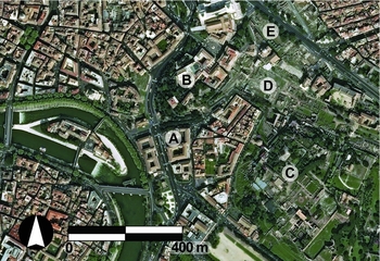
Figure 1. Satellite image of Rome showing key locations: A) Sant'Omobono in the Forum Boarium; B) Giardino Romano on the Capitoline Hill; C) Palatine Hill; D) Forum Romanum; E) Forum of Caesar.
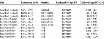
Nevertheless, in recent years, radiocarbon dating has confirmed the existence of late second-millennium BC contexts in Rome (Table 1). Most notably, excavations in the Giardino Romano on the Capitoline Hill have exposed early habitation levels. Although occasional Middle Bronze Age sherds have been found in later deposits, the earliest firm chronology at the site is associated with some terracing works, which are dated to the thirteenth century BC by ceramics and a single piece of charcoal (see Table 1; Baroni Reference Baroni2001; Cazzella Reference Cazzella2001: 267; Lugli & Rosa Reference Lugli and Rosa2001). Hearth features from a subsequent phase of the same site produced two additional 14C samples, which date to the end of the second or beginning of the first millennium BC (see Table 1; Boccuccia Reference Boccuccia2001; Cazzella Reference Cazzella2001: 268). In parallel with these discoveries on the Capitoline Hill, excavations in the Forum of Caesar have revealed another instance of terracing that is also dated by ceramics to the thirteenth century BC (De Santis et al. Reference De Santis, Mieli, Rosa, Matteucci, Celant, Minniti, Catalano, De Angelis, Di Giannantonio, Giardino and Giannini2010: 261–62). Following this initial phase of activity, three 14C samples on human (from two different individuals) and animal bone from a group of cremation burials in the Forum of Caesar have been dated to the eleventh and tenth centuries BC (see Table 1; De Santis Reference De Santis2001; De Santis et al. Reference De Santis, Mieli, Rosa, Matteucci, Celant, Minniti, Catalano, De Angelis, Di Giannantonio, Giardino and Giannini2010: 263–72). Although three skeletons found during excavations at the so-called ‘Equus Domitiani’ in the Forum Romanum produced comparable radiocarbon dates from the late second millennium BC, the interpretation of this deposit remains extremely problematic, and these dates should accordingly be regarded with caution (Gjerstad Reference Gjerstad1953: 49–52; Filippi Reference Filippi, Bartoloni and Benedettini2008: 634; Gusberti Reference Gusberti, Bartoloni and Benedettini2008: 648).
Table 1. Synthesis of available radiocarbon results from the late second millennium BC at Rome (Baroni Reference Baroni2001: 294; Cazzella Reference Cazzella2001: 267–68; De Santis Reference De Santis2001: 270; De Santis et al. Reference De Santis, Mieli, Rosa, Matteucci, Celant, Minniti, Catalano, De Angelis, Di Giannantonio, Giardino and Giannini2010: 264–66).
Extrapolating from the sporadic Bronze Age archaeological record, scholars posit that in the late second millennium BC, Rome consisted of a settlement on the Capitoline Hill, and possibly another on the Palatine (Coarelli Reference Coarelli1992: 112; Carandini Reference Carandini1997: 126–27; Cazzella Reference Cazzella2001; Filippi Reference Filippi2005: 98–100; Cazzella et al. Reference Cazzella, Baroni, Boccuccia, Lugli and Tabò2007; Fulminante Reference Fulminante2014: 69–72). This theory reflects and perpetuates the notion that settlements in Latium show a growing preference in this period for defensible hilltops, while funerary activity was largely relegated to the lowlands (Cazzella et al. Reference Cazzella, Baroni, Boccuccia, Lugli and Tabò2007: 808; Alessandri Reference Alessandri2013: 15, 29–53; Fulminante Reference Fulminante2014: 67, 175–177). Recent discoveries in the Forum Boarium valley, however, contribute much-needed data to the pattern of early human activity in the city, which greatly augment this conventional picture of Bronze Age Rome.
The Forum Boarium and Sant'Omobono sanctuary
Centrally located at the base of the Capitoline and Palatine Hills, and on the banks of the Tiber (Figure 1), the Forum Boarium valley became a vital commercial gateway for the city of Rome in historical times, and for central Italy more broadly. Proximity to the Tiber Island and a natural ford across the river made this a nodal point for interregional networks of trade and communication, before eventually serving as the city's first river harbour. Since its discovery on the western side of the Forum Boarium in 1937, the Sant'Omobono sanctuary has undergone repeated excavation, resulting in unique access to deep layers associated with a temple of the sixth century BC buried beneath the Republican sanctuary. As research in the region indicates that the Tiber River once flowed farther east than its modern position (Ammerman & Filippi Reference Ammerman and Filippi2004: 16–17), the ancient cult place was originally positioned on the banks of the Tiber and served as a backdrop for early harbour activity. The presence of Bronze Age pottery in secondary deposits at Sant'Omobono (Peroni Reference Peroni1962) has further fuelled the debate on early activity on Rome's floodplain, resulting in disagreement as to whether such finds should be interpreted as residual material from a settlement on the nearby Capitoline Hill, or as remnants of an early emporium on the banks of the Tiber (Coarelli Reference Coarelli1992: 112; Carafa Reference Carafa1996: 792–93; Carandini Reference Carandini1997: 113; Filippi Reference Filippi2005: 100–101; Angle & Guidi Reference Angle and Guidi2007: 172–74; Cazzella et al. Reference Cazzella, Baroni, Boccuccia, Lugli and Tabò2007: 805; Bartoloni Reference Bartoloni2009: 95). Although such inferences drawn from the Bronze Age sherds from Sant'Omobono are largely conjectural, there is general consensus that the Forum Boarium valley served as a strategic location for trade and communication since Rome's origins (Coarelli Reference Coarelli1992: 34, 107–13; Filippi Reference Filippi2005: 98–99).
Beginning in 2009, the Sant'Omobono Project embarked on a new endeavour to reinvestigate the sanctuary and review the site's uncertain archaeological interpretation with the help of modern methods (Brocato et al. Reference Brocato, Ramieri, Terrenato, Cangemi, D'Acri, De Luca, Giovagnoli, Pizzitutti and Regoli2012; Terrenato et al. Reference Terrenato, Brocato, Caruso, Ramieri, Becker, Cangemi, Mantiloni and Regoli2012; Brocato & Terrenato Reference Brocato and Terrenato2013). In 2013 and 2014, the Sant'Omobono Project began to investigate archaic levels with a two-phased research approach: deep trench excavation and percussion coring survey (Figure 2; Brock in press). Two trenches were excavated to a depth of over 5m to provide access to the earliest known levels of the site, below the modern water table. The first trench (D10) was positioned to expose a side of the archaic temple podium, and the other (A7) was placed within the western cella of the Republican twin temples. In the second phase of the campaign, Cobra TT drilling equipment was used to sample deeply buried layers across the site. In total, 18 boreholes, ranging in depth from 3–7m, produced over 70m of stratigraphic data, including multiple data points at and below sixth-century BC levels. This combination of deep trench excavation and percussion coring has afforded unprecedented access to archaeological and geological layers over 10m below the modern street level. In doing so, our team discovered undisturbed contexts that prove the existence of human activity in the Forum Boarium valley during the late second millennium BC for the first time.

Figure 2. Plan of the Sant'Omobono Sanctuary showing the 2013–2014 investigations of early levels, with the locations of two deep trenches (A7 and D10) and of 18 percussion boreholes; note the position of the five boreholes drilled at the bottom of trench A7; the borehole shown closest to the northern edge of the trench was produced prior to the excavation and did not reach the depth of the Bronze Age deposits.
Context of the dated seeds
Prior to the 2014 campaign, the earliest stratified contexts at Sant'Omobono dated to the seventh century BC. Beneath these archaic deposits, a thick deposit of culturally sterile alluvial sediment extends below the sanctuary; this layer was interpreted as the natural lower limit of the anthropic sequence at the site (cf. Ammerman & Filippi Reference Ammerman and Filippi2004: 17–18). While excavating a deep trench within the western cella, this alluvial sediment was predictably intercepted at 7.6m above sea level (hereafter asl). Upon reaching this natural boundary, our team concluded excavation of the anthropic levels and decided to core through the bottom of the trench primarily for the purpose of collecting supplementary environmental data (Figure 3). Below nearly 1.5m of alluvial deposits, however, there was a sharp transition to a dark, heterogeneous sediment with ceramic inclusions (Figure 4). In order to sample this newly discovered deposit thoroughly, we ultimately sank a tight cluster of five boreholes in a 2m2 area inside trench A7 (Figure 5). The deepest borehole (core 24) reached a depth of 2.6m asl and exposed two additional dark heterogeneous layers below the first.

Figure 3. View of the coring process at the bottom of trench A7 that produced evidence of deep anthropic deposits (photograph by Susan Grouchy).

Figure 4. View of two entries from core 23 after cutting and cleaning; the borehole starts at 7.6m asl with sterile alluvial deposits (grey sediment) covering anthropic deposit A at 6.1m asl (dark sediment), in which ceramic fragments and carbonised seeds were found (photograph by Andrea Brock).

Figure 5. Plan of trench A7 within the western cella at Sant'Omobono.
The borehole cores showed that between 6.1 and 3.2m asl there are at least three discrete deposits (A, B and C) of possible anthropic activity, each consisting of a very dark (e.g. Munsell colour 10YR 3/1) clayey silt matrix with inclusions of tuff, river pebbles, gravels, charcoal and shell. These dark deposits are interspersed between layers of alluvial sediment, which generally have a reduced colour (e.g. Munsellcolour 2.5Y 5/2) and traces of iron mottling (Figures 4 & 6). The anthropic layers do not have the colluvial soil structure that would result from erosion from the Capitoline Hill. Instead, they appear to have formed in situ on the banks of the Tiber River. The uppermost deposit (A) is the best documented and includes ceramic fragments, which are small and only sufficiently diagnostic to indicate a date sometime during the Bronze Age–Iron Age transition.

Figure 6. Schematic diagram of the deep stratigraphy exposed in the boreholes beneath the western cella at Sant'Omobono (drawing by Andrea Brock).
Methods and results
Following the coring process, sediment samples from the three dark deposits were taken for flotation, which yielded several charred seeds from deposits A and C (Figure 6). Of these seeds, four cereal grains were submitted for an initial round of radiocarbon dating (Table 2). The remaining seeds are currently under study. AMS radiocarbon dating was conductedby Beta Analytic (Miami, Florida). Pre-treatment of the seeds was performed with routine acid/alkali/acid washes. Table 1 includes dates listed as conventional radiocarbon age (BP) with a conservative 1σ (68.2%) range of 30 years. The calendrical calibrated ranges were plotted on the IntCal13 calibration curve (Talma & Vogel Reference Talma and Vogel1993; Reimer et al. Reference Reimer, Bard, Bayliss, Beck, Blackwell, Bronk Ramsey, Buck, Cheng, Edwards, Friedrich, Grootes, Guilderson, Haflidason, Hajdas, Hatté, Heaton, Hoffmann, Hogg, Hughen, Kaiser, Kromer, Manning, Niu, Reimer, Richards, Scott, Southon, Staff, Turney and van der Plicht2013) and are shown in Table 2 at the 95.4% confidence level. All short-term intervals caused by irregularities in the calibration curve were combined to produce a single calibrated date range.
Table 2. Radiocarbon dates from cereal grains found in the deposits deep beneath the western cella at Sant'Omobono.

* Elevation ranges are for the flotation samples that contained the cereal grains.
Discussion
The high reliability of these dates is reflected in the small sigmas as well as the consistency of the date ranges across four samples; when placed together, these factors strongly corroborate our findings as a well-dated in situ sequence. As all four samples from Sant'Omobono were charred seeds, it is improbable that they experienced significant movement after their original deposition. Unlike charred wood, which can survive in abundance and contaminate later contexts with earlier dates, the delicate material of these samples would indicate that these contexts were not heavily disturbed by post-depositional processes.
Given the narrow window of visibility permitted by the five boreholes at the bottom of a single deep trench, it is difficult to determine precisely what type of activity was taking place in this area. Generally speaking, the stratigraphy is not consistent with burial activity. As documented in the Forum Romanum and Forum of Caesar, early burials at Rome were often concentrated in the low-lying areas and typically involved small cuts into natural layers (De Santis Reference De Santis2001). A more precise explanation for the complex sequence of alternating alluvial and anthropic layers in the Sant'Omobono boreholes requires further testing in order to determine the spatial and temporal extent of the human activity. The similarity of date ranges for the upper and lower deposits (A and C respectively) does not permit a finer chronology at this time but nonetheless indicates that these deposits were created within a relatively narrow timeframe. It will be necessary to gather more information, particularly for the lower deposits (B and C), which were deeper and more difficult to access. At this preliminary stage, however, it is worth noting the position of these deposits (at 3.2–6.1m asl) in relation to Tiber flood levels. Prone to periodic and unpredictable flood events, the Tiber could rise to a level of 10–13m asl each year in the pre-modern period (Ammerman Reference Ammerman1990: 636–38; Aldrete Reference Aldrete2007: 51–90). These events would certainly have inundated any early activity in the Forum Boarium valley with several metres of water for days at a time. The thick layers of alluvial sediment and the narrow date ranges between deposits A and C connote the frequency of inundations and rapid sedimentation rate in the valley during the late second and early first millennia BC. Moreover, the dynamic nature of the floodplain and the frequency of floods probably accounts for the alternating pattern of alluvial and anthropic layers, which in turn may be the product of intermittent or seasonal occupation of the valley (cf. Ammerman Reference Ammerman1998: 220–21). Although ongoing work in the Forum Boarium will help to resolve the timescale for these events more satisfactorily, a number of river-related activities could have reasonably occurred in the region during the late second millennium BC, including transportation, trade and flood-mitigation efforts, as well as maintenance and improvement of the riverbank.
The 14C dates from Sant'Omobono represent a significant advance in empirical data from prehistoric Rome, as these results identify a very rare example of securely dated anthropic deposits from the late second millennium BC (see Table 1). This is the first definitive proof for human activity on the banks of the Tiber River as early as the twelfth century BC. Previous studies of Bronze Age Latium have accepted the premise of settlement almost exclusively on defensible hilltops (Cazzella et al. Reference Cazzella, Baroni, Boccuccia, Lugli and Tabò2007: 808; Alessandri Reference Alessandri2013: 15, 29–53; Fulminante Reference Fulminante2014: 175–77). These discoveries at Sant'Omobono augment this model by offering convincing evidence for early human activity and environmental impact in the floodplain as well. The strategic location in the Tiber River Valley, where the early inhabitants of Rome had their first river harbour, has probably served as a key position for the regional movement of people and goods since at least the late second millennium BC.
Conclusion
Given the dearth of archaeological evidence for Rome in the late second millennium BC, this discovery significantly extends the timeline of human activity in the Tiber Valley and provides promising new data on Rome's origins. It is probable that other contemporaneous deposits have yet to be found, and it may be hypothesised that pre-urban activity on the site of Rome was more substantial than formerly believed. This may be especially true of lowland areas, where there could be significantly deep layers, still well preserved and possibly waterlogged, and offering great potential for future discoveries of importance. More work is required to explore these deposits in the Forum Boarium. Given their sheer depth (>10m below the modern street level), they would be extremely difficult to excavate. Extensive coring survey is, at present, the most efficient and productive method for sampling such layers over a wider area. Accordingly, the next phase of the project plans to conduct an intensive coring survey from street level across the entire Forum Boarium. Mechanised drilling machines, which are capable of sinking boreholes up to 50m in depth, will facilitate further investigation of the chronology and spatial extent of these deep anthropic layers beyond the confines of the Sant'Omobono precinct. Ultimately, this new data will be collated to enable an environmental and topographic reconstruction of the valley as it changed and developed throughout the second and first millennia BC.
Acknowledgements
The Sant'Omobono project is promoted by the Sovrintendenza ai Beni Culturali di Roma Capitale in collaboration with the Università della Calabria and the University of Michigan. We would like to express our thanks to Paolo Brocato, Giovanni Caruso, Monica Ceci and Laura Motta for their participation in, and support of, this project. We are grateful to Albert Ammerman for consulting on the coring strategy in the field, Daniel Diffendale for providing essential topographic expertise for the project and producing our maps, and Robert Tykot for kindly reading an earlier draft of this paper. We are also grateful for assistance from the Istituto Nazionale di Geofisica e Vulcanologia in Rome. Finally, this research would not have been possible without a talented and dedicated team of Italian, American, Greek, Canadian and Swedish students in the field. This work was supported by a National Science Foundation grant (number 1259122). All opinions, findings and conclusions or recommendations expressed in this material are those of the authors, and do not necessarily reflect the views of the National Science Foundation.


