


Introduction
The physical remains of archaic states hold the clearest evidence available of the decisive social and political processes that accompanied the creation of complex societies. State-level societies are rare in the prehistoric Pacific (Kirch Reference Kirch2010; Hommon Reference Hommon2013); the archaic Tongan state is the only known polity in Oceania to extend political control over an entire archipelago and to influence islands beyond its borders (Petersen Reference Petersen2000; Neitzel & Earle Reference Neitzel and Earle2014). Traditional history and sparse archaeological data have long suggested that the Tongan state emerged in eastern Tongatapu at Heketa in the twelfth–thirteenth centuries AD, and after the capital was relocated to Lapaha the state reached its height around AD 1500 following an aggressive campaign of inter-island warfare conducted by the twenty-fourth holder of the title paramount Tu'i Tonga (Lord of Tonga) (Bott Reference Bott1982; Burley Reference Burley1998: 368).
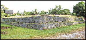
The premier monument of the Tongan state is the royal tomb Paepaeotelea (Figure 1) in the chiefly centre of Lapaha on the main island of Tongatapu (‘sacred Tonga’). The tomb is the largest prehistoric structure made in worked stone in the South Pacific, and contains blocks of coral limestone weighing over 20 tonnes. The tomb is traditionally linked to the twenty-ninth paramount Uluakimata I who, on genealogical grounds, ruled Tonga around AD 1600 (Gifford Reference Gifford1929). The size and assumed age of Paepaeotelea is consistent with a development sequence in which major architectural projects were undertaken by the state several centuries after its emergence, when the Tongan polity was at its greatest extent (Kirch Reference Kirch1984; Aswani & Graves Reference Aswani and Graves1998: 151). New archaeological research presented in this paper indicates, however, that Paepaeotelea was in fact built between AD 1300 and 1400, which changes our understanding of the Tongan state in three significant respects. First, the most energy-expensive and stylistically complex example of monumental architecture is probably the oldest of the royal tombs at Lapaha. Second, the tomb marks a dramatic increase in the scale of mortuary structures and land modification, representing substantial extraction of labour by an early archaic state. Third, the presence of stone tools associated with the tomb and geochemically sourced to multiple islands, indicates frequent, long-distance voyaging and the growth of the tributary base. As Baines and Yoffee (Reference Baines, Yoffee, Feinman and Marcus1998: 229) note: “There is a clear correlation between monuments and centralization”, and Paepaeotelea indicates that within 100 years the early Tongan state was able to organise and command the resources of the scattered archipelago.

Figure 1. Right) plan view of the central place of the Tongan state at Lapaha, showing the division between the residence, tombs and land of the Tu'i Tonga in the east, and the junior Tu'i Ha'atakalaua line located on reclaimed land holding the J20 tomb in the west. Left) plan view and cross-section of Paepaeotelea (J20).
Tomb description
Paepaeotelea (tomb J20) is located in Lapaha village on the inner shoreline of the Fanga ‘Uta Lagoon where the ancient capital of the Tongan state (Figure 1) was founded in around AD 1300 by the twelfth Tu'i Tonga. In Tongan traditions, J20 is associated with the twenty-ninth Tu'i Tonga Uluakimata I (also known as ‘Telea’) who lived around AD 1600. The structure is famous for its massive limestone blocks that were reputedly made on ‘Uvea Island and taken 850km to Tongatapu on the giant voyaging canoe Lomipeau (Martinello Reference Martinello2006). The tomb is the current burial place of the family that holds the bloodline of the Tu'i Tonga. Records indicate that at least four individuals have been interred in J20 since 1900 (1907, 1935, 1999 & 2010).
The J20 tomb is rectangular (26–28m × 41.5m) and has three levels of stone work (Figure 1). The basal and second tiers are constructed from carefully fitted blocks of coral limestone, except for two beach-rock slabs in the eastern and western walls of the second tier. The third tier is made of slabs that form when stratified beach sediments are cemented with calcium carbonate in the inter-tidal zone. The basal limestone blocks are raised above current ground level by 0.5–1.0m, but excavation reveals that the lower blocks have a total height of 1.9–2.3m and were placed in the intertidal zone when land around the tomb was reclaimed after construction.
The total amount of quarried stone in J20 was initially estimated at 519 tonnes (Clark et al. Reference Clark, Burley and Murray2008), but block dimensions recorded during tomb conservation in 2014 indicate that the structure probably contains around 700 tonnes of stone. This is a conservative estimate based on a specific gravity value for limestone of 1.9±0.2 tonnes/m3; those measured Tongatapu limestones vary from 2.06–2.44 (Harrison Reference Harrison1993). Basal tomb blocks have a mean length of 3.6m and an estimated mean weight of 10.1 tonnes, with the largest block weighing around 33 tonnes. Features that are specific to J20 include a rebate on many of the blocks made by trimming the exterior face to create a smooth facing, and to mark the land fill height; ‘L’ shaped corner blocks designed to stop wall-spreading; bevelled superior surfaces (on three corners); and the angled exterior face of blocks in the second tier (Figure 2). In addition, J20 is the only tomb in Tonga to be built by placing blocks on the surface of the inter-tidal zone with land then reclaimed around it.

Figure 2. A) View of Paepaeotelea (J20) from the south. The coral limestone blocks of the basal tier are partially buried in reclaimed land. B) LiDAR view (colour by elevation) of the ground surface surrounding J20 and J21. Note the addition of a soil layer used to hold the slabs of J21 (green) and the old lagoon edge (dark red). Rectangles on J20 represent modern and prehistoric vaults identified with GPR in 2008–2009; blue-purple areas are sand mounds marking historic burials. The central vault is of prehistoric age.
Ground-penetrating radar (GPR) and LiDAR surveys of Paepaeotelea were made in 2008–2009. The GPR survey (43 transects, 0.5m spacing, 108 traces per transect, 200Mhz antenna) identified four vaults distributed east–west across the middle of the tomb (Figure 2). The central vault is of prehistoric age and is flanked by two historic interments (1935, 1999). To the west is a small vault, also probably dated to the historic era.
Tomb age
The location of Paepaeotelea in the intertidal zone and the reclamation of land around the tomb made 14C dating of the structure difficult, but in 2013 a test pit (TP.B) located on the western side revealed a lens of in situ charcoal sandwiched between a lower layer of coral pebbles (patapata) and an upper cemented crust of fine-to-coarse carbonate particles (Figures 3 & 4). Geochemical analysis of the carbonate crust and a limestone flake from J20 indicated that the cemented crust (Layer 5) is limestone debris, which was produced by shaping the tomb blocks (Table 1). As the charcoal lens must have been deposited after the first tier of the tomb was built (see below), three samples of nut endocarp (Aleurites moluccana) from the charcoal layer were identified using a Transmitted Light Zeiss microscope and dated using SSAMS at the Research School of Earth Sciences (ANU).

Figure 3. South profile of TP.B showing reclaimed land deposit of coral and limestone boulders (Layer 1), limestone debris (Layer 2, Layers 4–5), a soil deposit added to hold the slabs of the nearby J21 tomb (Layer 1), and a charcoal lens dated with SSAMS (Table 2).

Figure 4. Map of quarry areas and pathway/road used to transport blocks from the south to J20, and location of TP.B near J20. White squares are test pits without limestone gravel and black squares have the distinctive gravel that was found beneath the south block (Figure 5). A northern quarry area is suggested by an abandoned limestone slab to the north of J20 and a thick deposit of buried limestone gravel in the north quarry.
Table 1. Geochemical results using X-ray fluorescence on Paepaeotelea (J20) limestone block fragment, limestone from the south quarry and TP.B construction debris (see Figure 4).

Calibrated nut endocarp and a marine shell result (Wk-18771) show that J20 was constructed between AD 1300 and 1400 (Table 2), and was one of the first royal tombs to be built after the Tongan state relocated from Heketa to Lapaha (Clark & Reepmeyer Reference Clark and Reepmeyer2014). Deposits of limestone debris from construction of the J20 tomb were also traced in excavations on the north-west and south-east of the neighbouring J21 tomb, where additional samples of marine shellfish, charcoal and stag horn coral (Acropora sp.) were collected from the reclaimed land. Results from unidentified charcoal and marine shell associated with J20 construction sediments (Wk-12813, Wk-12815) also indicate a date of c. AD 1300–1400, as did a sample of fresh Acropora sp. coral (Wk-36850) from a lens of branch coral fragments placed over a layer of carbonate boulders that was sealed by a fine compact lime sand (Table 1).
Table 2. Radiocarbon and U-Th age results. SSAMS ages were calibrated using CALIB 7.1, with terrestrial ages adjusted with the SH calibration curve and marine samples using a ∆R of 11±83 14C years for open ocean marine organisms, as suggested by Petchey and Clark (Reference Petchey and Clark2011).

1. U-Th ages were calculated at the Centre for Microscopy and Microanalysis at the University of Queensland, as described by Burley et al. (Reference Burley, Weisler and Zhao2012). Note that ET-A4 is an age on the least altered grains of an Acropora sp. sample, while WZ-A4 is a duplicate age on the second best grains of the same piece of coral.
2. U-Th ages not calibrated with CALIB 7.1.
Previous work shows that high-precision U-Th ages can be obtained for branch coral from Pacific archaeological sites (Sharp et al. Reference Sharp, Kahn, Polito and Kirch2010; Burley et al. Reference Burley, Weisler and Zhao2012). Two samples of fresh stag horn coral from the layer dated by Wk-36850 were therefore tested. The U-Th ages for the least altered grains range from AD 1272 (WZ-A4) to AD 1302 (ET-A4), and are slightly older than the nut charcoal results, possibly due to multiple intercepts associated with variation in the Southern Hemisphere calibration curve. A replicate sample of ET-A4, run on the second best grain fraction, gave a similar result (WZ-A4, AD 1272±6.2), indicating that Paepaeotelea may have been built as early as AD 1300.
Quarry areas
Around 90m south of J20 a large piece of limestone was found protruding above the ground surface during survey and was excavated with the aid of a mechanical digger (Figure 4 ‘south block’, and Figure 5). The fragment was part of a limestone block with a worked face lying on a bed of light yellow-brown limestone gravel that had been buried in a deposit of transported soil, 0.66m thick. The block had been fractured in the past and the remaining section, weighing around 500kg, had been abandoned (Figure 5). The limestone gravel under the block was around 0.34m thick and at high tide was 0.15–0.20m above the water level. South of the worked block there was a limestoneextraction area close to a ditch section (Clark et al. Reference Clark, Burley and Murray2008). Excavation of the quarried area revealed cut limestone (Figure 4). An associated sample of charcoal was dated to AD 1300–1400 (Wk-33587).

Figure 5. Partially buried worked limestone block (see ‘south block’ Figure 4), recovered from the south quarry area. Due to its thickness, the block was probably intended to be used in the second tier of J20, and the transverse fracture suggests it broke during transport.
The distinctive limestone gravel under the broken block suggested the use of quarrying debris to make a road or pathway for the transportation of blocks. A shovel survey of 93 pits tracked the gravel deposit, which was identified in 52 shovel pits at 0.60–0.82m depth; the ‘road’ or debris zone was clearly directed towards the south of the tomb (Figure 4). Excavation of a trench along the limestone shoreline north of J20 revealed 0.55m of a silty, dark brown soil over a 0.35m deposit of limestone rubble, along with a partially detached block consistent with a north quarry zone (Figure 4).
Construction sequence
On Tongatapu, the outer edges of the limestone shoreline are regularly cut by wave erosion, fractures and freshwater solution channels. These areas appear to have beenopportunistically quarried by wetting the limestone and using volcanic stone tools to cut channels or holes, and perhaps using dampened wooden wedges and levers to break off large blocks. Studies show that the compressive strength of limestone is significantly reduced by water saturation (Parate Reference Parate1973), and the limestones of Tongatapu can absorb large amounts of water, as they are highly porous (Harrison Reference Harrison1993: 15).
The worked face of the abandoned block fragment had been reduced by percussion, and a transverse fracture suggests that it broke during transport (Figure 5). In the basal tier, the majority of tomb blocks have exterior faces that have been worked below the current surface, with a rebate made to even the tomb wall above ground level. This indicates that blocks were ‘roughed out’ and, after being manoeuvred into approximate position, the exposed vertical and horizontal block faces were aligned by trimming. There is substantial variation in block dimensions (Figure 1) as a result of the uneven karst structure.
The first stage of land reclamation involved the placement of large coral and limestone boulders collected from the intertidal zone around basal tomb blocks, with the probable construction of a ramp(s) over the basal tier on the south-west side, up which the second tier blocks were moved. The interior of the tomb was filled with loose coral gravel (patapata), and the second tier blocks were placed on the gravel, with subsequent slumping/compaction causing minor block displacement. Many of the second tier blocks also display a rebate at ground level, showing that the same labour-intensive method used in the first tier was employed to dress and align the tomb walls. The origin of the beach rock slabs used in the third tier is not known, as many small beach quarries are known on Tongatapu and nearby carbonate islands. Water sieving of reclaimed land sediments recovered fragments of polished volcanic tools, demonstrating that the final shaping of the limestone blocks, particularly the trimming and alignment of exposed wall faces, was undertaken using stone adzes. Excavations showed that a buried layer of coarse-to-fine, yellow-white limestone sediment extends from the north-west wall of J20 at least 60m westward.
Finally, a thick deposit of dark brown soil was brought to the site to hold the beach rock slabs of the nearby J21 tomb, as the reclaimed land would have made accurate slab positioning difficult. The soil deposit is 0.70–0.80m deep on the south-east side of J21 and reduces to 0.20–0.25m on the north-west side of J20 (see Figure 2).
Discussion
The oldest tombs at Lapaha are often known by several names, indicating a loss of information about the earliest funerary structures of the Tu'i Tonga (Clark Reference Clark, Martinsson-Wallin and Thomas2014). For example, while genealogical lists record 39 Tu'i Tonga (Gifford Reference Gifford1929), the resting places of many key historical figures, such as the tenth, eleventh, twelfth, twenty-third and twenty-fourth Tu'i Tonga, are not known with any certainty. Uluakimata I, the twenty-ninth Tu'i Tonga, is reputed to be buried at Lapaha in either J20 or J21, in Samoa (Manu'a Island), or he was lost at sea and the J20 tomb was built as his memorial (Thomson Reference Thomson1902: 86; Gifford Reference Gifford1929: 57; LTC 2012). The association of J20 with Uluakimata I, although widely assumed, is unclear, with the missionary John Thomas (Statham Reference Statham2013: 29) identifying ‘Telea’ as an early Tu'i Tonga; a tradition from Lapaha identifies ‘Telea’ as the tomb builder rather than a Tu'i Tonga (Fonua Reference Fonua2002). The earliest European mention of the J20 tomb was made during Dumont d'Urville's 1827 visit to Tonga, when the draughtsman Louie Auguste de Sainson made a sketch map showing the relationship of several tombs. These included J20, which he described as a “memorial to the chief Telea [emphasis added], who was lost at sea” (Maurat Reference Maurat1833). It may be significant that de Sainson distinguished between the tombs of ‘rois/kings’ (cf. Tu'i Tonga) and those of ‘chiefs’, suggesting that ‘Telea’ may have been the tomb builder. Another local account indicates that ‘Paepaeotelea’ is a descriptive name that has been corrupted, as ‘paepae’ in Tongan means the ‘stones forming the surrounding wall or border of a house-mound or grave-mound’ (Churchward Reference Churchward1959) while ‘tele'a’ means ‘to plane or smooth’ (tele) a ‘fence’ (‘a), possibly in reference to smoothing the limestone block surfaces. What is not in doubt is that J20 is a tomb, actual or intended, of a Tu'i Tonga, as it has features that are exclusively associated with other royal tombs at Lapaha, including a large rectangular plan, stepped form, common orientation, stone vault and a substantial stone facing (Figure 1).
Loss of information might also be involved in traditions that tell of the J20 limestone blocks being transported 850km from ‘Uvea to Tongatapu. It has long been known that the quarry sites on ‘Uvea, where the J20 blocks are traditionally said to have been cut, are volcanic outcrops and not limestone (McKern Reference McKern1929); a situation confirmed during a visit to ‘Uvea in 2009 by two of the authors. It is feasible, however, given the close ties between Tonga and ‘Uvea in late prehistory, that ‘Uveans might have been involved in the construction of J20 (see Sand Reference Sand, Di Piazza, Pearthree and Sand2008).
In addition to the 14C and U-Th dating results, an early age for the J20 tomb is suggested by its location and other evidence for limestone quarrying. Large blocks of coral limestone occur at the first centre of the Tongan state at Heketa, where a trilithon, containing two shaped limestone supports weighing 22 and 26 tonnes respectively, was made by quarrying coastal limestone in around AD 1300 (Clark & Reepmeyer Reference Clark and Reepmeyer2014). Limestone was also quarried at Lapaha during the construction of a ditch system, provisionally dated to AD 1300–1400, which tapped the freshwater aquifer and delineated the compound of the Tu'i Tonga (Clark et al. Reference Clark, Burley and Murray2008).
The location of the J20 tomb to the west of the old shoreline is anomalous, as the main concentration of Tu'i Tonga tombs are positioned on the clay soils to the east of the old shoreline (Figure 1). Traditions indicate that at the time of the twenty-fourth Tu'i Tonga (c. AD 1500), the government of the Tongan state became a diarchy with the lower (western, reclaimed) land occupied by a collateral chiefly line (Tu'i Ha'atakalaua), and the upper side (eastern, clay soils) associated with the Tu'i Tonga. This spatial division represents the functional separation between the sacred Tu'i Tonga and an administrative ‘working chief’ who was responsible for practical government (Bott Reference Bott1982).
There are several difficulties in reconciling the traditional history of the land reclamation and construction of the J20 tomb by the twenty-ninth paramount Uluakimata I. First, although traditions place land reclamation at the time of the twenty-fourth Tu'i Tonga (AD 1500), any land fill would have had to be removed in order to build J20 if it was constructed by Uluakimata I (AD 1600). Second, placing the J20 tomb on reclaimed land already occupied by a junior chiefly line makes little sense given the spatial separation of chiefly lineages with the Tu'i Tonga in the east and Tu'i Ha'atakalaua in the west (Figure 1). It is more probable—given the consistent dating results—that J20 was built when the entire area was used by the Tu'i Tonga, and the spatial division occurred later, leaving the J20 and J21 tombs in an area occupied by the junior paramount.
Our investigations show that the most energy-expensive structure made by the Tongan state at Lapaha, given the size and weight of its coral limestone blocks, was also one of the first to be built. The only older royal burial structure at Heketa contains some 56 tonnes of beach rock, and the largest slab weighs 0.75 tonnes (Clark & Reepmeyer Reference Clark and Reepmeyer2014). In contrast, the J20 tomb required more than 12 times the amount of stone, and 99 per cent of its limestone blocks weigh more than a tonne. The effort needed to extract and shape limestone blocks is not known, but must have been significant, as Spennemann (Reference Spennemann1989a: 117) records that the removal of 0.4m3 of coral limestone during pit digging at Lapaha took two men with metal tools four hours. Labour estimates for moving megaliths suggest that to move the largest J20 block would have required 495–660 people (Heizer Reference Heizer1966; Spennemann Reference Spennemann1989a), which accounts for around 3–4 per cent of the total prehistoric population of Tongatapu (Burley Reference Burley, Kirch and Rallu2007).
The royal tombs of the Tu'i Tonga are sacred structures and, when quarried, the fresh surfaces of the J20 blocks would have been highly reflective, as limestones typically have a solar reflective index (SRI) of 0.4–0.7. A now-buried surface of yellow-white limestone construction debris, extending at least 60m to the west of J20, might represent a plaza or courtyard, suggesting that the tomb was meant to be viewed by canoes entering the Fanga ‘Uta Lagoon. Tradition notes that a sheltered canoe anchorage was a key reason for relocating to Lapaha, emphasising the importance of canoe transport in the maritime polity. If the area of reclaimed land was initially restricted to the area around J20 then the tomb would have been a light-reflective white stone structure located on a small artificial promontory, surrounded by water.
Geochemical analysis of stone tools recovered from J20 and from the north and south quarries identified volcanic material from Central Tonga, ‘Eua Island, Samoa and Fiji (Clark et al. Reference Clark, Reepmeyer, Melekiola, Woodhead, Dickinson and Martinsson-Wallin2014). The presence of stone tools from these islands was previously thought to reflect the political connections of Uluakimata I, who was traditionally known to have had a chiefly wife from Samoa and a daughter who married a Fijian chief (Bott Reference Bott1982). The growth of the tributary base by the time of Uluakimata I, suggested by the sourcing results, matched a view that the polity reached its greatest extent after conquest warfare of neighbouring islands by the twenty-fourth Tu'i Tonga (AD 1500) prior to state collapse after AD 1790 (Bott Reference Bott1982; Spennemann Reference Spennemann1989b). The new, early age of J20 indicates that this view of state development is wrong, and that long-distance voyaging, strategic marriage alliances and impressive monumental architecture were a feature of the early Tongan state.
Conclusion
The preconditions that assisted the rise of archaic states (first generation/pristine states) include the presence of several non-state polities engaged in intensive interaction, in addition to long-distance trade and warfare (Stanish & Levine Reference Stanish and Levine2011). Such conditions supported the emergence of highly organised core polities that, in some instances, dominated entire regions and, through strategic outposts, expanded their influence to the surrounding periphery. One of the poorly resolved issues about the rise of complex entities relates to state formation and the specific mechanisms and length of time required to create a centralised political entity from smaller autonomous political units. A second issue, relevant to the Tongan case, relates to state power and whether archaic states, once formed, needed centuries to acquire control over the landscapes and people of the titular state, or whether early polities exerted control from the outset over a wide range of human and material resources within state borders.
Tongan traditions, supported by new archaeological data, assert that critical changes to the political system and management of land were made by just three lineal generations of Tu'i Tonga: the tenth Momo, eleventh Tuitatui and twelfth Talatama (Gifford Reference Gifford1929; Campbell Reference Campbell2001; Clark & Reepmeyer Reference Clark and Reepmeyer2014). In this short period, the first stone structures were built at Heketa, then, after the move to Lapaha, much larger projects were begun including a limestone-cut ditch system, lagoon reclamation and the construction of the remarkable J20 tomb that marked the state centre. The new architectural innovations, especially those involving the quarrying of coral limestone, materialised the apex status of the Tu'i Tonga at a scale not seen previously. Recognition that Paepaeotelea is probably the first of the royal tombs to be built at Lapaha demonstrates that the early Tongan state could command a significant work force, while volcanic stone tools sourced to Fiji and Samoa, and the presence of ‘Tongan’ fortifications in east Fiji and ‘Uvea, indicate early long-distance interaction and warfare (Best Reference Best1984: 657–58; Sand Reference Sand, Di Piazza, Pearthree and Sand2008; Clark et al. Reference Clark, Reepmeyer, Melekiola, Woodhead, Dickinson and Martinsson-Wallin2014).
Elsewhere in the Pacific, archaic state emergence on Maui in the Hawaiʻian Islands was signalled by a major phase of temple construction that began around AD 1550, as determined from 230Th dating of ritual deposits of coral. Kirch et al. (Reference Kirch, Mertz-Kraus and Sharp2015) hypothesise that rapid temple building represents the management of agricultural production and extraction of tribute by elites. Supporting this view are the royal genealogies of Hawaiʻi that place the consolidation and expansion of the Maui polity at c. AD 1570. Rapid state influence is also seen in Tonga where a dispersed agrarian society was assembled to build the central place of the polity with the work requiring the substantial extraction of corvée (unpaid) labour by early generations of the leadership dynasty. The monumental centre of Lapaha and the Paepaeotelea tomb indicate that newly constituted elites quickly appropriated and commanded the vast human and material resources that derive from political centralisation, and that some early archaic states were organised, powerful and geographically expansive entities.
Acknowledgements
We thank the Nobles of Lapaha, the Honourable Kalaniuvalu-Fotofili and Princess Mele Siu'ilikutapu and Lord Vaea (Chair of the Tongan Traditions Committee and Minister of Internal Affairs when the research was carried out). We would like to acknowledge the efforts of the late Kalaniuvalu (d. 2010, b. Paepaeotelea), who was instrumental in the documentation of Lapaha's heritage, and Christophe Sand, who facilitated our visit to ‘Uvea in 2009. Fieldwork was supported by an Australian Research Council Future Fellowship grant to Clark (FT0990591) and funding from the School of Culture, History and Language (ANU) to Christian Reepmeyer. We are grateful to the two reviewers for their constructive comments, which improved the paper.


