Introduction
Archaeological remains of the Hongshan period (4500–3000 BC) are spread widely across north-eastern China, including the Liao, Daling and Xilamulun river valleys of western Liaoning and eastern Inner Mongolia (Figure 1). Monumental stone-faced, earthen platforms with large bottomless ceramic cylinders (tongxingqi), and burials containing jade artefacts carved with supernatural themes are the traditional hallmarks of the emergence, during Hongshan times, of some of the earliest complex societies in eastern Asia (Figure 2). Scholars are unanimous in according a ceremonial or ritual function to these monumental constructions. Information about social organisation, subsistence and other economic activities comes from Hongshan settlements. Farming, hunting and foraging were all practised to differing degrees by different households; as were pottery, stone tool, jade and other kinds of craft production, while inter-household differences in status and wealth suggest a social hierarchy (Peterson & Lu Reference Peterson, Lu and Underhill2013). Systematic regional-scale settlement study shows settlement clusters or supra-local communities, often centred on ceremonial platforms. Ritual and ceremony seem to be the principal centripetal forces that drew people together into supra-local communities or districts, and formed the basis of leadership in these small regional polities (Chifeng International Collaborative Archaeological Research Project 2011; Peterson et al. Reference Peterson, Lu, Drennan and Zhu2014).

Figure 1. The Hongshan core zone and periphery.

Figure 2. Hongshan circular platforms (bottom), carved jades (top left), tongxingqi cylinders (top centre), and tongxingqi surrounding a platform (top right).
Hongshan monuments are most numerous and elaborate in what has been labelled the ‘core zone’ (Peterson et al. Reference Peterson, Lu, Drennan and Zhu2010). Monuments in the ‘periphery’ have yielded fewer jade artefacts with different stylistic and symbolic characteristics. Nearly all Hongshan human-representational art (in jade, stone, ceramic and unfired clay) comes from the core zone. Reconstruction of regional organisation is based on comprehensive systematic settlement survey in the Upper Daling valley (in the core zone and including the excavated ceremonial centre at Dongshanzui), and the Chifeng region (in the periphery). Comparison reveals little difference between core and periphery in the spatial and demographic scale of Hongshan communities (Drennan et al. Reference Drennan, Peterson, Lu, Zhu and Hou2014). Both regions contained multiple supra-local communities, each composed of smaller local communities (villages and hamlets). These districts measured a few kilometres across; their estimated populations were in the low to high hundreds.
Within the Hongshan core zone, the area of Niuheliang stands out for its especially large concentration of ceremonial architecture (Liaoning Institute of Archaeology 2012). Some two dozen locations with monuments are found within an area of a few tens of square kilometres (Figure 3). Most of these monuments are similar in form to those built elsewhere during the Hongshan period, although they are larger and better made. Most contain one or more well-constructed burial crypts in which a handful of jade artefacts, but nothing else, accompanied the dead. A very deep burial chamber in a platform at Locality 16 contained unusual jades, including a large bird and a human figurine. Rows of tongxingqi encircling platforms are also especially abundant at Niuheliang, and some locations of ritual activity are identified simply on the basis of high densities of tongxingqi sherds. At some locations there is evidence for the sequential building, enlargement and renovation of platforms (Lu & Zhu Reference Lu, Zhu and Fei2002). Unique monuments include: the irregularly shaped and highly decorated semi-subterranean ‘Goddess Temple’ at Locality 1—in which a life-sized, seated female figure made of clay was found—and the large artificially levelled area behind it that could have accommodated a few hundred people; a tall, conical mound of earth and stone at Locality 13; and specially prepared pits lined with stones at Localities 1 and 5, where sets of ceramic vessels were placed before the pits were back-filled with earth.
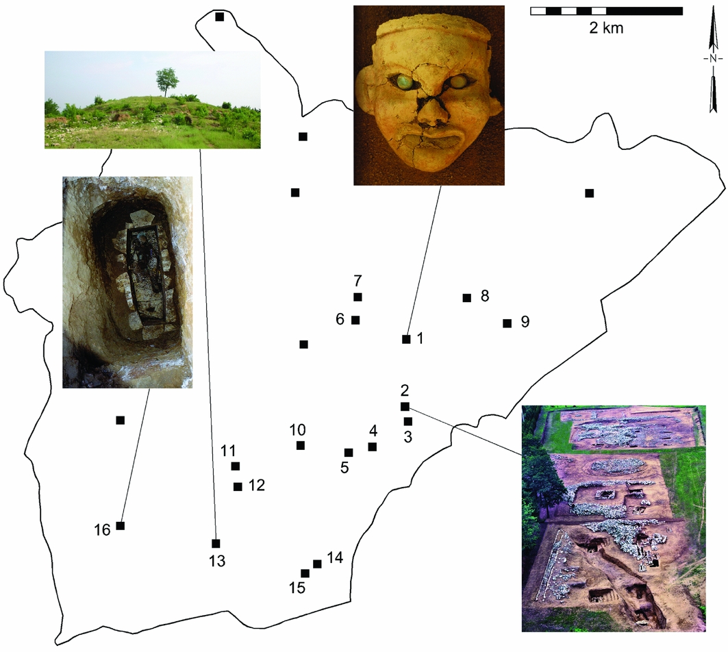
Figure 3. Ceremonial structures in the Niuheliang survey area.
Its archaeological remains stand out so strongly for their unique characteristics and high quality that Niuheliang is seen as the Hongshan artistic, architectural and cultural apogee. Just what this means in terms of human organisation, however, has been the subject of conflicting views. This place, with the most unusual and aesthetically outstanding examples of Hongshan art and architecture, has been taken to be the largest and most highly developed Hongshan settlement or polity—even the capital of an empire representing the political integration of the entire territory through which Hongshan artefacts occur (Guo Reference Guo and Nelson1995; Nelson Reference Nelson, Claessen and Oosten1996; Yan Reference Yan1996; Li Reference Li2008: 97–98). On the other hand, the architecture and public spaces of Niuheliang have been described as lacking associated residential remains and representing a vacant ceremonial centre, built and used by people who lived far away and came to Niuheliang as pilgrims, solely to participate in ritual activities including the burial of important individuals, also perhaps from far away (Liaoning Institute of Archaeology 1997; Lee & Zhu Reference Lee and Zhu2002). These two contrasting accounts of the context and purposes of the art and architecture at Niuheliang clearly spring from very different visions of the nature of Hongshan society.
Settlement survey at Niuheliang
In part to provide archaeological evidence to help choose between these contrasting visions, the Liaoning Province Institute of Archaeology carried out, in 2014, a systematic complete-coverage settlement survey of 42.5km2, including the principal localities of Hongshan monumental architecture at Niuheliang (Liaoning Institute of Archaeology & Renmin University of China 2015). This area had, of course, been intensively scrutinised over several decades for traces of ceremonial construction, but remains of prehistoric occupation had not previously been recorded systematically all across it. The survey followed standard methodology, with teams of three archaeologists walking back and forth across the entire landscape at intervals of about 50m. Visibility of surface artefacts was generally good, and collections of surface sherds were made so as to assess the density of ceramics of each period. Surface scatters over areas larger than 0.25ha were subdivided into smaller units collected separately. Population estimates were based on the area and density of surface sherd scatters. Field methods and approaches to demographic analysis and community delineation were identical to those used in the Upper Daling regional survey and are described fully by Peterson et al. (Reference Peterson, Lu, Drennan and Zhu2014: 27–29).
The earliest evidence of human occupation encountered pertained to the Hongshan period. This was found in some abundance throughout the survey area, representing a total population estimated at 350–700. About three-quarters of these people lived in 10 small, dispersed villages, the largest of which did not exceed 100 inhabitants at the most (these are the tallest peaks in Figure 4). The remainder were widely scattered in tiny hamlets and individual homesteads (the lower bumps in the figure). Sherds of tongxingqi cylinders were less broadly distributed across the survey area, forming some 15 small, high-density clusters (Figure 5). Most of these clusters correspond to platforms that have been excavated or are visible on the surface, and most platforms present high densities of tongxingqi sherds. The ceremonial locations at Niuheliang were mostly in a band running from south-west to north-east near the margin of the survey area (Figure 5). Outside this band, tongxingqi sherds occurred only at much lower densities.
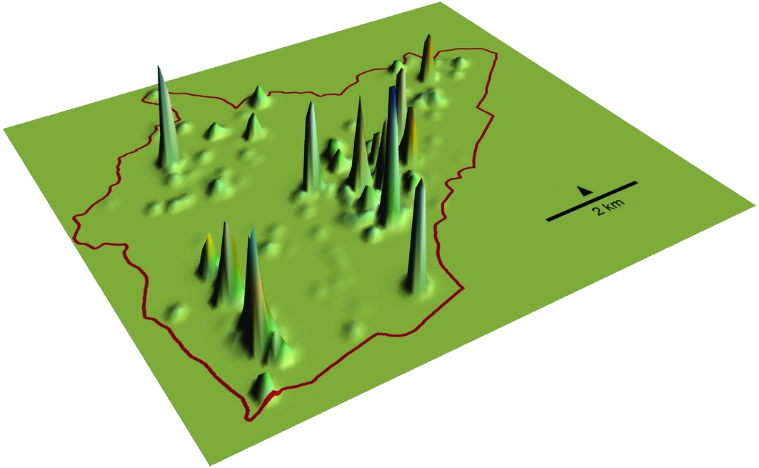
Figure 4. Distribution of Hongshan-period occupation in the Niuheliang survey area. Higher peaks indicate higher densities of surface sherds from the utilitarian vessels of daily living.
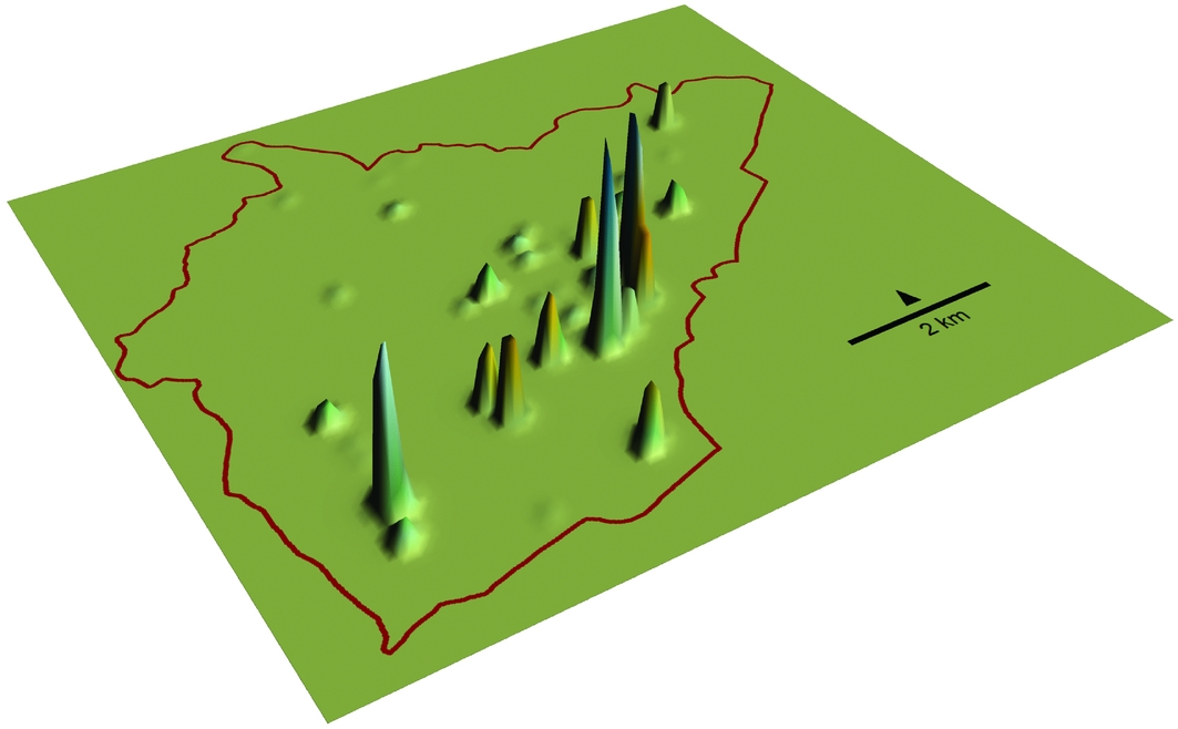
Figure 5. Distribution of Hongshan-period tongxingqi sherds in the Niuheliang survey area.
The trends of population distribution at the regional scale are more clearly visible in a smoothed density surface (Figure 6). The two large clusters, and two of the three small ones, correspond well to locations of ceremonial activities, falling in the same band where tongxingqi sherd clusters and platforms were abundant (Figure 7). This band, where evidence of ceremonial activities is especially concentrated, contains more than 85 per cent of the population of the survey area. At the smallest scale within this band, however, occupation does not usually cluster immediately adjacent to ceremonial locations, some of which are several hundred metres from the nearest evidence of occupation, and only one of which corresponds closely to a sizable cluster of settlement (Locality 16 near the south-western corner of the survey area). Some ceremonial structures are on top of ridges, where steep slopes discourage settlement; for example, in the area between the two largest clusters of occupation where Localities 11, 12 and 13 are found.
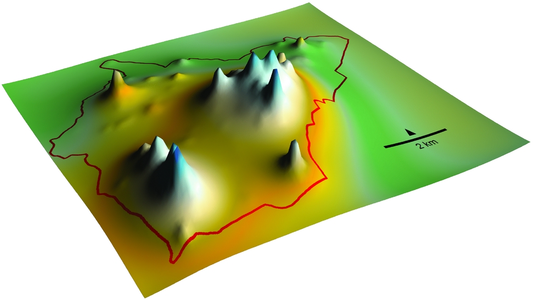
Figure 6. Mathematically smoothed Hongshan occupation density surface for the Niuheliang survey area.
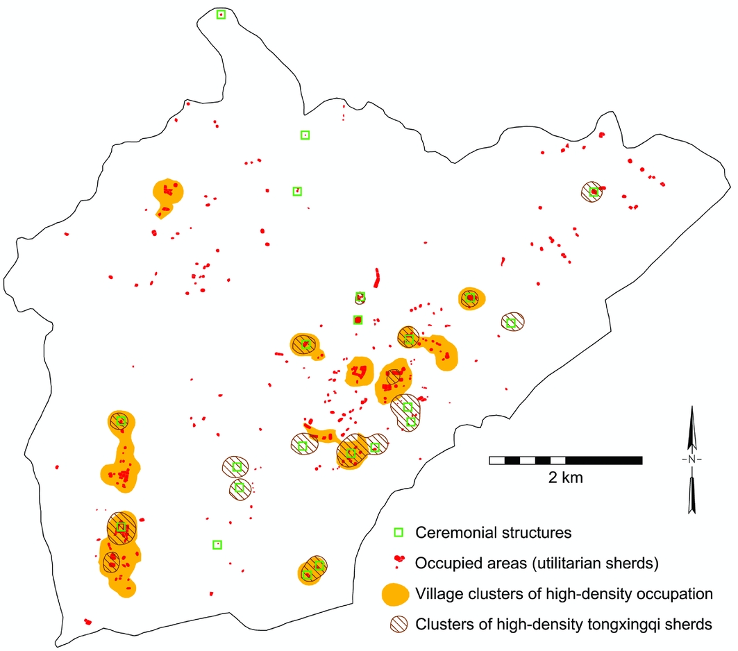
Figure 7. Distribution of Hongshan-period occupation, villages and ceremonial activity in the Niuheliang survey area.
Settlement outside the south-west to north-east band of occupation and ceremonial activities is much more scattered. There is only one village (with fewer than 40 inhabitants), the rest of the occupation in the north-western sector consisting of tiny hamlets and individual residences (Figures 4 & 7). The three ceremonial structures here are quite small and very isolated from the places where people lived. Despite its small and scattered population, this sector is where the most productive farmland in the survey area is found: fertile soils, gentle southward-facing slopes and good water supply. Later, during Lower Xiajiadian (2000–1200 BC) and Zhanguo-Han (600 BC–AD 200) times (and in the present), this territory was strongly favoured by farmers (Liaoning Institute of Archaeology & Renmin University of China 2015). Most of the Hongshan population, then, was not optimally located for agricultural production, but seems to have been drawn instead into the general (but not immediate) proximity of the major ceremonial structures.
Systematic settlement survey is thus conclusive: the zone where the principal ceremonial structures of Niuheliang were located also shows considerable evidence of human occupation. The monuments were not isolated in a region where no one lived. Within the region, moreover, the distribution of occupation corresponds well to the locations of ceremonial activities. Such observations are possible only when the classification of sites into mutually exclusive ‘habitation’ or ‘ceremonial’ categories (Zhang et al. Reference Zhang, Bevan and Guo2013) is abandoned and it is recognised that people often engage in ceremonial activities within habitation zones. It is essential to note that most evidence of occupation is so dispersed that it would not be identified as a ‘site’ at all, and has thus gone unrecorded by heritage inventory surveys.
Niuheliang and other regions
Two other systematic regional settlement studies provide information to compare with Niuheliang. The Upper Daling survey area of 200km2 is only 25km to the south-east of Niuheliang, still within the Hongshan core zone; 125km to the north-west, in the Chifeng region, 1234km2 were surveyed in the periphery (Figure 1). With no more than 100 inhabitants, the largest village in Niuheliang is dwarfed by villages of 500 or more in Chifeng and Upper Daling. The populations of Hongshan supra-local communities in both the core and periphery range from a few hundred to nearly 1000 people. Their areas are highly variable, but most are between 20 and 60km2. The entire Niuheliang survey area, with 350–700 people in 42.5km2, would thus fall into the normal size range for a single Hongshan district, both demographically and spatially. If it were surrounded by substantial additional settlement, enlarging the territory and population of a cluster around Niuheliang, then it might stand out as an especially large supra-local community, which could represent the top tier of macro-regional political integration, as some have thought.
It is very unlikely, however, that this is the case. Towards the north-eastern limit of the survey, density of occupation declines substantially, suggesting the beginning of a sparsely settled buffer zone separating a Niuheliang cluster from whatever may lie beyond. Denser settlement does approach the other survey boundaries. Systematic settlement survey has not been extended in these directions, but they have certainly received considerable archaeological attention. To the south-east are mountain ridges, with one known ceremonial location but very little occupation. Given the steep slopes and thin soils, this is not surprising, and the south-eastern edge of the survey zone marks the beginning of a very sparsely settled area that probably extends right through the 25km of rugged mountains that separate Niuheliang from the Upper Daling valley. To the north-west also are rugged mountains that surely contained very little Hongshan occupation. The only real possibility for additional occupation to enlarge the Niuheliang population cluster lies towards the south-west. At least some evidence of occupation is indeed known in this direction just outside the survey area, and it could possibly continue farther in that direction. Even if it did, however, it would need to extend quite a long way at high density to enlarge the Niuheliang cluster enough to make it a top macro-regional tier. And in that case, it would create a very peculiar supra-local community whose population was not concentrated on its putative centre at Niuheliang, which would not even be in a central location, but far off to one end of a very elongated territory. This is certainly not the way population distribution is organised in other Hongshan districts or in regionally centralised, complex societies generally.
If the Niuheliang survey zone does represent a population cluster extending a modest distance farther to the south-west, it would still have a spatial and demographic scale similar to other Hongshan districts, but its demographic distribution would be atypically decentralised. At the largest documented Hongshan supra-local community (around Dongshanzui), for example, almost all of the population is concentrated in a central area of less than 20km2, surrounded by another 65km2 of almost empty territory. The smaller population of the Niuheliang survey zone is spread across an area more than twice as large as the Dongshanzui population is, indicating weaker internal centripetal social forces than those that created other Hongshan districts. The distribution of population instead seems to respond to pulls from the dispersed scatter of ceremonial locations. There is thus no support for the idea that Niuheliang represented an especially large, highly developed regional Hongshan polity, much less the capital city of an extensive Hongshan political empire. While its scale is commensurate with known Hongshan districts, its internal demographic characteristics do not resemble those of normal Hongshan regional polities.
Aggregated systematic data on ceremonial activity reinforce the subjective impression widely agreed upon in the Hongshan literature that ritual was emphasised in the core zone and especially at Niuheliang. The 24 locations of ceremonial activity identified in the Niuheliang survey zone represent about one for every 15–30 people (or 0.6 ceremonial locations per km2). In the Upper Daling survey area, the 26 ceremonial locations represent one for every 30–60 people (or 0.1 per km2). The Chifeng survey zone in the Hongshan periphery contains only five identified Hongshan ceremonial locations, representing one for every 500–1000 people (or 0.004 per km2). Tongxinqi sherds comprise 12 per cent of the Hongshan sherds collected at Niuheliang, 10 per cent of those in Upper Daling and 1 per cent of those in Chifeng. The evidence for ritual activities is thus considerably more abundant in the core zone, and especially at Niuheliang. It should be noted that methodological differences may cause this evidence to be somewhat underrated for Chifeng, but even if the Chifeng numbers were multiplied by a factor of five (far more than a plausible estimate of the incompatibility), there would still be a dramatic difference between core zone and periphery.
Temperature and precipitation differ slightly between Niuheliang, Upper Daling and Chifeng, but factors affecting agricultural productivity vary much more substantially within each of the three areas. The highest productivity in this part of north-eastern China depends on the fertile, deep, well-watered soils of flat valley floors and gently rolling uplands. Productivity in all three survey zones is much lower on steep slopes, where thin, stony soils have less capability of retaining moisture. Land at both extremes of this continuum occurs in all three zones, but the more productive land is in especially short supply in the Niuheliang survey area, which contains a high proportion of steep ridges. Despite the relative scarcity of more productive soils in the Niuheliang survey area, it actually had a higher population density in Hongshan times than Upper Daling or Chifeng (8–16 people per km2, compared to 4–8 and 2–4, respectively). Clearly, these people were not attracted to live at Niuheliang because of especially high agricultural productivity.
Niuheliang and political administration
The circular and square platforms of Niuheliang, sometimes including burials, are generally similar to those of other places throughout the Hongshan core zone and periphery, although some are particularly large and well-built, and some very deep tombs contained especially elaborate jade carvings. The ceremonial activities at such structures have been assigned a small-scale political role in integrating the regional polities or districts of the Upper Daling and Chifeng regions. Even though the scale of Niuheliang does not indicate a central place at the top tier in a macro-regional hierarchy, it is at least conceivable that it played a larger-scale political role transcending ordinary regional polities.
Localities 1 and 13 seem unique in the Hongshan world. No structure comparable to either the Goddess Temple or the tall conical mound is known elsewhere. Neither, however, suggests a political function. The large, level area adjacent to the Goddess Temple did provide a place where large numbers of people could assemble, but this was not qualitatively different from the level spaces that customarily surround platforms. A residential structure covering 50m2 has been excavated 60m away from the Temple. While this is larger than average, even larger houses have been excavated at Hongshan sites, both in the core zone and in the periphery. The Goddess Temple itself was a small, cramped structure, which could accommodate only a very limited number of people. This, together with its imposing larger-than-life female clay figure, suggests it was more likely a highly restricted sacred space than a building for political administration.
The conical mound at Locality 13 sits atop a three-tiered platform constructed much like other platforms, although it covers a larger area, is higher and does not contain a tomb. The entire structure was faced with stone and equipped with tongxingqi and other special vessels. It is difficult to make an argument that this structure had especially political functions as it seems suitable for the same kinds of activities as other platforms, and the 2014 survey reveals that it is especially isolated from any evidence of the occupation expected at administrative locations. These two most unusual of Niuheliang's structures thus seem, if anything, less political in character than the others.
All of the evidence currently available then, substantially augmented by recent systematic regional settlement study, shows that Niuheliang was not a major population centre, a large-scale, highly developed regional polity, or the focus of macro-regional political integration. A number of major sites of early complex societies have been imagined in these terms: Mississippian Cahokia or Moundville; San José Mogote and then Monte Albán in Oaxaca; Cuicuilco in the Basin of Mexico; Olmec La Venta; Late Yangshao Dadiwan or Dawenkou Dantu in the Yellow River valley; Tell al ‘Ubaid in Mesopotamia; Argaric south-eastern Spain, among others. Niuheliang, however, does not fit this pattern. At the same time, its local resident population was substantial—on the scale of previously known Hongshan districts, although the internal distribution of that population is less centralised than is usual in such supra-local communities. Niuheliang was not a vacant ceremonial centre, but the lives of its people may well have focused particularly heavily on the ceremonial or ritual activities that are so strongly in evidence there.
Niuheliang, ritual and the local population
This all leaves interesting yet difficult questions about whether and just how Niuheliang might have played a special macro-regional religious—but not political—role in Hongshan life, who the people who lived there were and just what they did for a living. The notion of a pilgrimage centre falls readily to hand for characterising a place with little or no macro-regional political function, but where there is abundant evidence of ritual activity, and especially ritual facilities of an unusual nature, like those described above—facilities that might have been constructed for activities that did not occur anywhere else in a large region or that related to unique supernatural characteristics of the place. It has been suggested that Niuheliang was orientated towards a mountain in which some see the shape of a boar's head, or possibly a bear's head (Barnes & Guo Reference Barnes and Guo1996). Such a specific suggestion is probably beyond the possibilities of empirical confirmation after 6000 years, even though boars and bears both do appear in Hongshan iconography (along with fish, owls and other birds, turtles, insects and more). This is nonetheless exactly the kind of belief that could have given Niuheliang special significance in the Hongshan religious imagination and led to rituals that did not occur in other places. These are the characteristics of places to which pilgrims travel, sometimes over long distances.
In the context of Hongshan society, which consisted of a large number of small-scale political units in which leadership was played out in the context of religious ritual, one might well imagine that visitors to Niuheliang from afar particularly included the ritual practitioners of the many small regional polities. Visiting Niuheliang, partaking of its special religious significance and participating in religious activities that did not occur elsewhere might well have been of great importance to elites from all parts of Hongshan territory. They may have interacted in this way with the most revered of Hongshan religious figures at Niuheliang. It is, of course, also possible that the visitors included a broader cross-section of Hongshan society, for whom a pilgrimage could have been a pivotal life-event. Whoever, exactly, the visitors might have been, this general line of thinking is consistent with the abundance of ceremonial architecture at Niuheliang, the unique character of some of that architecture, the absence of political or administrative facilities, the presence of a local population, its relatively modest demographic scale, and the way in which the local population was oriented to ceremonial places, but was not as centralised as in most Hongshan districts.
Unanswered questions
Unique architecture designed to inspire awe or special reverence, the spread of stylistic and iconographic elements to distant places, and extant but relatively small local populations have been seen as indicators of pilgrimage centres for Chaco Canyon and Nasca Cahuachi (Kantner & Vaughn Reference Kantner and Vaughn2012), as well as for Chavín de Huántar, Ohio Hopewell and numerous other examples. These same characteristics at Niuheliang suggest that it too might plausibly be a pilgrimage centre. What is lacking, however, is more direct empirical evidence that there really were visitors from afar to this unique, specialised, ritual community. It is not impossible to collect such evidence from the archaeological record.
If Niuheliang owed its existence to its role carrying out special rituals and hosting visitors from other places, residential architecture and especially household artefact assemblages would be different from those of more ordinary Hongshan communities (cf. Plog & Watson Reference Plog and Watson2012). The residences of specialised religious practitioners of a sort not seen elsewhere might have unusual characteristics or be close to ceremonial structures (cf. Kahn Reference Kahn2015). Their artefact assemblages might lack tools for ordinary productive activities, but have high proportions of artefacts of symbolic significance instead. Evidence of jade-working might be attached to their residences. Whether important people buried at Niuheliang were locals or came from other places could be determined by stable isotope analysis of skeletal remains. The general population of Niuheliang might have been strongly engaged in supporting such specialised religious practitioners and/or housing and feeding visitors. This could show up as distinctive features in residential architecture and as artefact assemblages emphasising food production and preparation rather than crafting activities. A comparative base for such studies already exists in the form of artefact assemblages from the Upper Daling and Chifeng regions, but such evidence has not yet been collected from Niuheliang.
As Niuheliang is not in a region of especially high agricultural productivity, a population dedicated to religious construction and ritual (as well as visitors who came there) might well have been sustained in part by agricultural production in adjacent areas. Given that the population estimates we have discussed are based on the area and density of surface ceramics, if some of those ceramics were actually used (and broken) by visitors, then those visitors would be included in the estimated average population of the Niuheliang survey area during Hongshan times (although they probably did not bring their ceramic vessels from home). This would mean that the permanent local population available for farming was even smaller. The prime candidates for additional food production would be two broad valleys, one to the south-west, where Lingyuan city is now, and the other to the north-east, where Jianping city is located. Systematic settlement survey in these valleys might reveal especially high population densities along with settlement distributions and artefact assemblages, suggesting relatively intensive food production.
A completely different possibility is that the high ratio of ceremonial facilities to population in Niuheliang might result from the relatively imprecise chronology currently available for Hongshan times. The entire period is some 1500 years long, and while there are some clues to more precise dating, these cannot yet be applied to settlement data, and only partially to ceremonial structures. They suggest, for example, that most of the ceremonial construction dates to the last 1000 years of the period. People might have settled the entire Hongshan area early in the period. If monument construction began around Niuheliang after some 500 years and only later spread to other parts of the Hongshan area, then more remains of ceremonial structures (relative to habitational debris) would have accumulated on the landscape at Niuheliang. This would exaggerate the impression of particularly intensive ritual activities and special macro-regional religious importance. An extreme view attributing the uniqueness of Niuheliang largely to a palimpsest effect, however, does not seem at all probable. Radiometric dating, for example, shows that settlement and ceramics associated with the ceremonial construction at Dongshanzui in the Upper Daling region date back to the very beginning of the Hongshan period. More stratigraphic excavation, though, might make it possible to distinguish ceramics from different parts of the Hongshan period. Large-scale archaeometric dating of remains would also help to disentangle possible palimpsests in our reconstructions of this long period.
Systematic regional-scale settlement study at Niuheliang has complemented the long history of excavation of ceremonial structures there, and at least narrowed the possibilities for reconstructing Niuheliang's regional and macro-regional role and the nature of human organisation in Hongshan times. In order to address questions that remain unanswered, we need not just more information and larger samples in general, but particular kinds of research in particular places. Further systematic settlement study in the two valleys adjacent to the 2014 Niuheliang survey area would help to determine whether food production there helped to sustain a specialised religious community at Niuheliang. Additional excavation of residential structures and intensive surface collection of artefact assemblages at the household scale in occupation areas at Niuheliang (whose locations are now known) would help to determine just what activities the local population was engaged in and how these may have differed from those of Hongshan communities elsewhere. Raw material sourcing and other archaeometric research on samples of materials properly contextualised in human communities and households would contribute to the same goal. In addition, more precise dating of monument construction and use, of burials, households and changes in settlement distribution would provide a finer-grained picture of the dynamics of Hongshan society.