


Introduction
Monumental enclosures, defined by ditches and banks, are a widespread prehistoric phenomenon. Among the best-known examples are the so-called ‘rondels’, or Kreisgrabenanlage—circular timber enclosures surrounded by ditches and banks with several entrances—that emerged across much of Central Europe prior to the mid fifth millennium BC. Although this period is sometimes considered an interlude, marking a time between the spread of agriculture and the rise of the first metal-based societies, it nonetheless has the potential to be the ‘big story in the middle’—a time when the ways in which people lived together underwent a major transformation across the continent (Whittle Reference Whittle2018: 223–24). In Central Europe, this process can be tracked through the regionalisation of material culture, the interregional circulation of exotic raw materials and artefacts, a redefinition of pottery decoration, and changes in domestic architecture and settlement layout. The most striking among these changes is, we contend, the emergence of monumental rondel architecture.
Excavations of rondels typically reveal no more than circular ditches and palisade trenches, with diameters ranging between 30 and 240m, enclosing a largely empty interior space that is accessed via two to six entrances. These features provide few clues as to what activities took place within the circular enclosures, or what roles they may have played in Neolithic society. Even after five decades of research, these questions remain much debated. Recently, interpretations emphasising defensive functions and the corralling of livestock have been largely abandoned in favour of an emphasis on astronomical observation and as places for social gatherings, ceremonial games or religious rituals (e.g. Pásztor et al. Reference Pásztor, Barna and Roslund2008; Bertemes & Meller Reference Bertemes and Meller2012; Petrasch Reference Petrasch, Fowler, Harding and Hofmann2015; Řídký et al. Reference Řídký2019). Unlike other European Neolithic monuments, rondels were closely linked with domestic activity and are always found within areas of settlement, or with nearby residential structures. Typically, a single rondel was constructed on a settlement and was surrounded by other occupied sites without enclosures. It has been suggested that these rondels functioned as central places, defining a shared focal point for a region (e.g. Lobisser & Neubauer Reference Lobisser and Neubauer2005: 16; Stäuble Reference Stäuble and Schmotz2007: 175; Bertemes & Northe Reference Bertemes, Northe, Bertemes and Meller2012: 38). The construction and use of these focal rondels brought together people from a wider territory and served to integrate previously separate communities (Petrasch Reference Petrasch1990: 514–15, Reference Petrasch, Bertemes and Meller2012: 63; Neubauer Reference Neubauer and Schmotz2007: 225–28).
In this article, we challenge this interpretation by putting more emphasis on the somewhat overlooked phenomenon of multi-rondel sites, where two or more rondels were built within the area of a single settlement—often close together. We believe that such sites provide the basis for a more complex understanding of rondel communities and reveal aspects of their socio-spatial organisation, raising questions regarding the role of rondels in the process of community integration. To explore these issues, we analyse the spatial, formal and chronological characteristics of multi-rondel sites; we then introduce an approach to Bayesian modelling that considers the deposition of the material from which dated samples derive, using the multi-rondel site of Praha-Krč as a case study. We conclude with a discussion of the concept of translocality among rondel-building communities.
The structure of multi-rondel sites
To date, 19 multi-rondel sites have been identified in Central Europe (Figure 1; for raw data, see online supplementary information (OSM) 1). Although single rondels were typical, multi-rondel sites were far from rare, making up 11 per cent of all known sites (for the most recent inventory, see Řídký et al. Reference Řídký2019: tab. 4.1). Multi-rondel sites have been recorded evenly across both the western and eastern cultural complexes of the Central European Middle Neolithic of the first half of the fifth millennium BC (western: Stroked Pottery Culture, Oberlauterbach group, Großgartach group, early Rössen Culture; eastern: Moravian-Austrian Painted Ware, Lengyel Culture). Despite some differences in the precise configuration of rondels (see below), the layouts of single and multi-rondel sites are comparable, and hence, we can assume that an analysis of multi-rondel sites will yield results that are relevant to the entire rondel phenomenon.
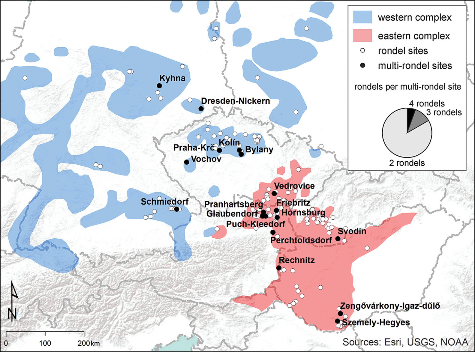
Figure 1. Map of analysed multi-rondel sites. The pie chart shows that only three sites accommodate more than two rondels (map by V. Vondrovský).
To examine whether multi-rondel sites were arranged according to a conventional pattern, we analysed the distances between the centres of neighbouring rondels and the distances between their outermost ditches (Figure 2). Both variables show a bimodal distribution; for example, the distance between neighbouring rondel centres shows peaks of 0–300m and 500–800m. This bimodal pattern can be linked to cultural affiliation: rondels of the western complex were built significantly closer together than those in the eastern region, where, although the range was wider, the intervals are also generally greater (distance of centres t-test: t = −3.13, df = 19, p <0.01; distance of ditches t-test: t = −3.1, df = 19, p <0.01) (Figure 2). Nonetheless, geomagnetic surveys at the eastern complex sites of Szemely-Hegyes in Hungary and Rechnitz in Austria indicate that even these more widely dispersed rondels probably related to single settlement (Bertók & Gáti Reference Bertók and Gáti2011: 12–13; Schiel et al. Reference Schiel, Jennings, Gaffney, Sparrow and Gaffney2017).
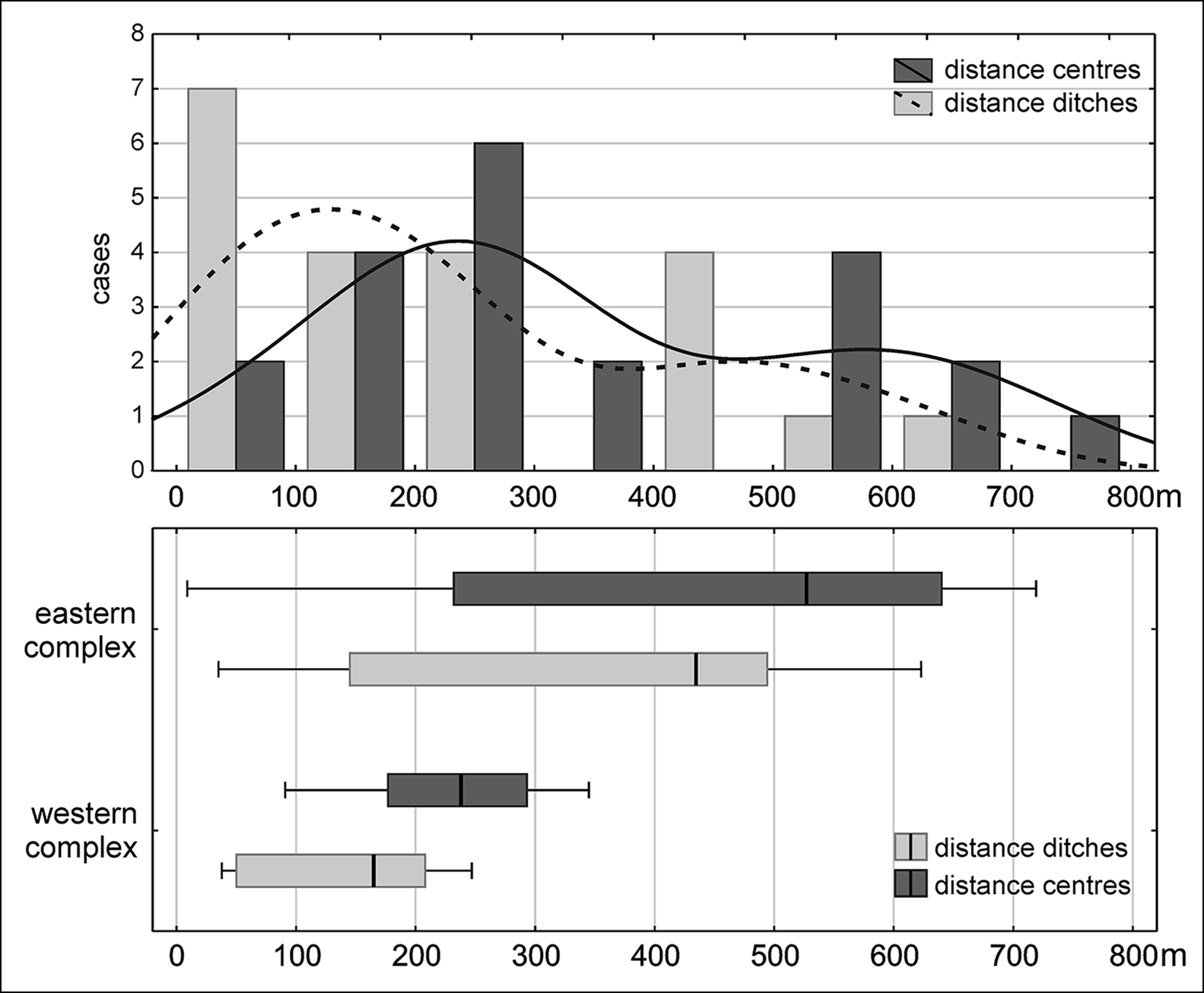
Figure 2. Histogram (top) showing the distances between the centres of neighbouring rondels and the distances between their outermost ditches. The boxplot (bottom) shows the same values distinguished by cultural affiliation (figure by V. Vondrovský).
The rondels constructed at multi-rondel sites do not follow a universal layout and several distinct types can be recognised (Figure 3). Most multi-rondel sites feature rondels of differing sizes (defined as the diameters of the innermost and largest outermost ditches) and number of ditches. The numbers of entrances and their forms can also vary, although in many cases these attributes cannot be reliably verified. In the cases where this information is available, the numbers of entrances vary between individual rondels at six out of 12 multiple-rondel sites, entrance forms differ at 10 out of 17 sites, and entrance orientation varies between rondels at eight out of 12 sites. Variation in ditch depth and width, and the presence of inner palisade trenches may also be potentially meaningful, although these elements are often affected significantly by erosion and hence are not considered in this analysis.
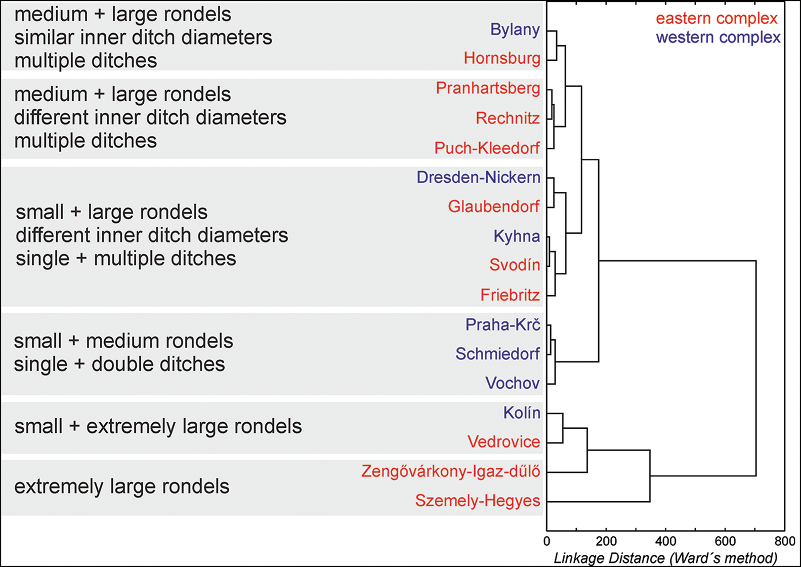
Figure 3. Multivariate clustering of multi-rondel sites based on the number of rondels, number of ditches, and the diameter and variance of inner and outer ditches (figure by V. Vondrovský).
Contemporaneous or successive?
The next essential step is to examine the temporal development of multi-rondel sites: were the individual rondels constructed simultaneously or in succession? The evidence to date has been limited. At Schmiedorf in Bavaria, a double trench surrounding both rondels is assumed to be an indication of contemporaneity (Trnka Reference Trnka1991: 277). At Bylany in the Czech Republic, geomagnetic survey has identified a single surrounding trench that encloses one rondel (rondel 4/1) but intersects all three ditches of another (rondel 4/2). The stratigraphic relationships between these features, however, await confirmation by excavation (Pavlů et al. Reference Pavlů, Rulf and Zápotocká1995). It should also be noted that in both of these cases, the evidence relates to associated features rather than directly to the rondel enclosures. This is not the case at Svodín in Slovakia. Here, a smaller rondel (1) is situated off-centre within a larger rondel (2), leading to the assumption of successive construction (Němejcová-Pavúková Reference Němejcová-Pavúková1995). As this layout is unique among known multi-rondel sites, however, the general validity of the chronological pattern is disputable. Two successive circular enclosures have also been recorded at Sormás-Török-földék in Hungary (Barna & Pásztor Reference Barna and Pásztor2011). Although both enclosures exhibit the formal characteristics of rondel architecture, Sormás II was constructed during the earlier Sopot horizon—this proto-Lengyel Culture, which originated in the Croatian Slavonia region, expanded into the Transdanubia prior to 5000 BC (Obelić et al. Reference Obelić, Škrivanko, Marijan and Bronić2004)—and surrounded a densely settled area. This interior settlement distinguishes this enclosure from classic rondels, which tend to contain no substantial settlement structures. Therefore, only the Sormás I enclosure can be considered a rondel in the strictest sense (see Petrasch Reference Petrasch, Fowler, Harding and Hofmann2015) and Sormás-Török-földék cannot be considered as a multi-rondel site.
As the relative chronological evidence for the construction of multi-rondel sites is limited, here we focus on absolute radiocarbon dates and formal Bayesian modelling. We are nonetheless aware that, behind the mathematical precision of this method, the application of misleading priors regarding the taphonomy of rondel ditches can create potential pitfalls. Previously, the only radiocarbon dating of a multi-rondel site was undertaken by Řídký et al. (Reference Řídký2019: 121–34) at Kolín in the Czech Republic; there, however, the chronological relationship between the two rondels remains unspecified. In particular, where the radiocarbon dates contradicted the stratigraphy of the ditch infill, Řídký and colleagues employed the concept of reverse stratigraphy—that is, they modelled the sample sequences, or their constituent parts, in reverse order. Following Harris's (Reference Harris1989: 122–23) critique of reverse stratigraphy, here we propose a ‘residual-rondel-refuse’ sequence (explained below) as the fundamental framework for probabilistic modelling of rondel chronology. The framework is based on archaeological and sedimentological analyses undertaken at various rondel sites, as well as long-term observations of experimental V-shaped ditches (Lüning Reference Lüning1981; Bell et al. Reference Bell, Fowler and Hillson1996; Loishandl-Weisz & Peticzka Reference Loishandl-Weisz and Peticzka2007; Lisá et al. Reference Lisá2013; Řídký et al. Reference Řídký2014).
The framework generalises the following sequence. The lowest levels of infill in rondel ditches were formed by colluvial processes; this primary siltation contains no objects with close chronological connections to the date of ditch construction or use of the rondel. Instead, the objects recovered from the lowest deposits within the ditches relate primarily to domestic activities that took place prior to rondel construction. The spoil extracted from the digging of the rondel ditches, including these earlier objects, was used to build the adjacent banks. Protected from heavy weathering, the objects remained within the banks until gradual erosion redeposited them back into the ditches. After the momentum of initial bank erosion decreased due to vegetation growth on the banks, the middle levels of ditch infill developed. These comprise thin layers of further eroded material interspersed with organic-rich strata resulting from early rubbish disposal from daily activities at the adjacent settlement. Finally, deliberately deposited rubbish prevailed in the upper contexts of the infilled ditches; these layers are similar in nature to the fill of pits found on Middle Neolithic non-rondel settlement sites, and their creation is related to the final infilling of the rondel ditches (Lisá et al. Reference Lisá2015). Most of the objects recovered from the ditches come from these upper levels.
Taking all of these priors into consideration, the date of rondel construction can be modelled as an event delimited by a terminus post quem represented by the unstratified group of residual dates from the lowest levels and a terminus ante quem represented by the objects intentionally deposited in the upper levels. The contribution of dates from the middle levels requires individual consideration. It should also be noted that the upper levels, although formed by intentional rubbish disposal, may also contain some residual material—a phenomenon that is not uncommon in pits found on settlement sites (Končelová et al. Reference Končelová2019).
This residual-rondel-refuse framework is applicable not only to Central European rondels but could also be used for the formal chronological modelling of radiocarbon dates from other sites and monuments with V-shaped ditches. The only requirements for application are a similar three-component taphonomic history and the absence of significant later disturbance of ditch infill.
Case study: Praha-Krč
Praha-Krč, a district located in the south of the city of Prague in the Czech Republic (Figure 4), is an eminently suitable site for testing the residual-rondel-refuse framework. An area of 1.8ha, investigated during a rescue excavation in 2001, revealed the remains of a large, double-ditched rondel (1), a smaller, single-ditched rondel (2), four longhouses, and numerous pits with Stroked Pottery Culture (SBK) assemblages (Smejtek & Sušická Reference Smejtek and Sušická2009; Vondrovský & Smejtek Reference Vondrovský and Smejtek2020; Vondrovský Reference Vondrovský2021). The rondels were located approximately 40m apart, measured outer ditch to outer ditch. This is the shortest distance recorded at any multi-rondel site. Based on stratigraphy and analysis of artefacts and ecofacts, three principal ditch infill strata were identified: an upper level (AB), a middle level (C) and a base level (D). No evidence of ditch cleaning or recutting was recorded. Indeed, the northern parts of rondel 1 are partially infilled and covered by a Middle Neolithic occupation layer, which suggests a relatively rapid infilling process. The presence of an occupation layer also indicates that this area was not heavily affected by erosion, which might otherwise have eradicated some of the original deposits.
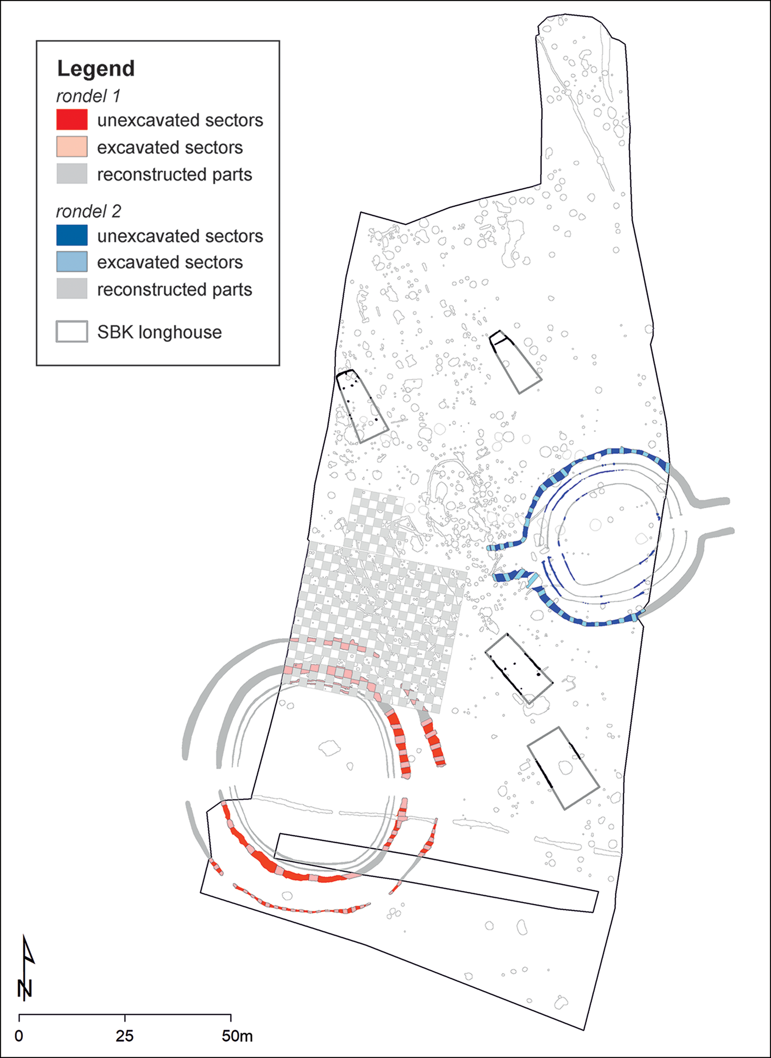
Figure 4. Praha-Krč: site plan (map by V. Vondrovský).
We have established an absolute chronology for the site based on 25 AMS radiocarbon dates on material recovered from the rondel ditches and associated contexts (see details in OSM2). Following Whittle et al.'s (Reference Whittle, Healy and Bayliss2011) method, our sampling targeted predominantly well-preserved herbivore bones to mitigate taphonomic risks and reservoir effects. Vertical sequences were sampled in various parts of the ditches where a sufficient distribution of animal bones was present (Figures 5 & 6). Despite the rigorous sampling method, five samples returned outlier dates; their calibrated ranges fall within the preceding Linear Pottery Culture (LBK; 5350–4950 BC), when the site of the future rondels was also occupied. As these five dates lie fully outside the period of rondel construction, they were excluded from the analysis. Chronological modelling was undertaken in OxCal v4.4, using the IntCal20 atmospheric curve (Bronk Ramsey Reference Bronk Ramsey2009; Reimer et al. Reference Reimer2020).

Figure 5. Praha-Krč: sampled contexts of rondel 1 and resulting radiocarbon ages BP. Black dots indicate sampled strata rather than the exact position of the bone (figure by V. Vondrovský).
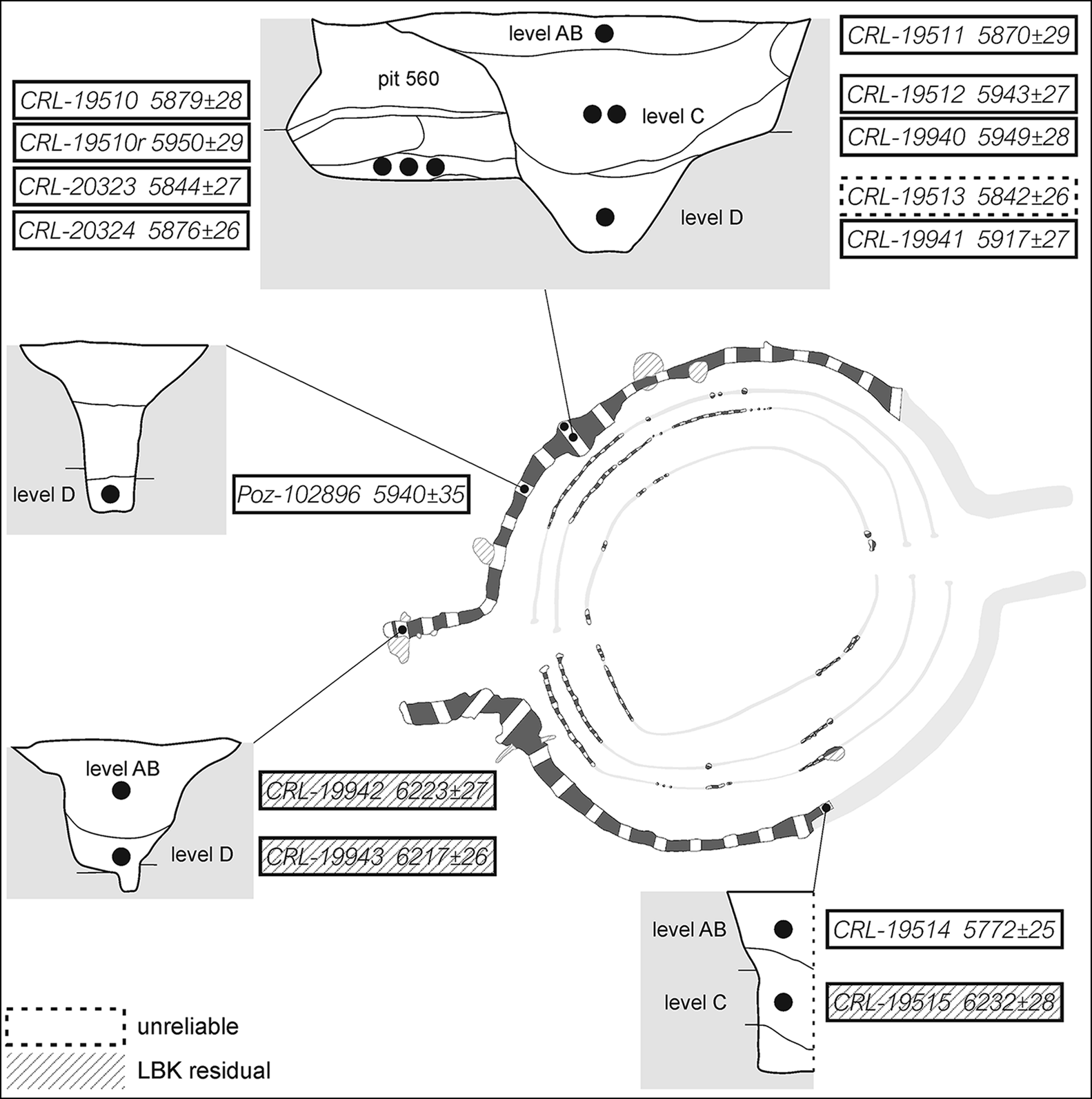
Figure 6. Praha-Krč: sampled contexts of rondel 2 and resulting radiocarbon ages BP. Black dots indicate sampled strata rather than the exact position of the bone (figure by V. Vondrovský).
The reliability of the residual-rondel-refuse sequence was confirmed by the model for rondel 2 (see also the consistency tests in the OSM). The model was based predominantly on radiocarbon dates from the north-western part of the rondel, where the ditch cut an earlier storage pit (pit 560) that also dates to the late SBK period. This relationship appears to be a crucial prior. If the stratigraphy is followed to the letter, the dates from pit 560 should precede all the dates from the ditch. The integrity of the sequence, however, is questioned by the CRL-19512, CRL-19940 and Poz-102896 dates, which are significantly older than that for pit 560 (see OSM3 and Table S5). In contrast, the modelled residual-rondel-refuse sequence fits with the recorded situation as excavated, and the model provides a solid index of agreement (Amodel = 140%) (Figure 7). In this model, level AB (upper) is defined by CRL-19514, because CRL-19511, which is chronologically consistent with the dates from pit 560, is suspected of being residual. Despite coming from ditch level D (lowest), CRL-19941 is modelled as part of the pit 560 group. This is because the sampled basal layer differed conspicuously in composition from any other strata recorded in the base of the ditch. We assume that this layer was formed by erosion of pit 560 after its infill was exposed on the steep-sided wall of the V-shaped ditch. Unlike other dates from levels C (middle) and D, CRL-19941 is consistent with the chronology of pit 560 (for consistency tests and alternative models, see OSM3). The results of the modelling set the ditch construction of rondel 2 at 4771–4633 cal BC (at 95% probability) or 4741–4679 cal BC (at 68% probability).
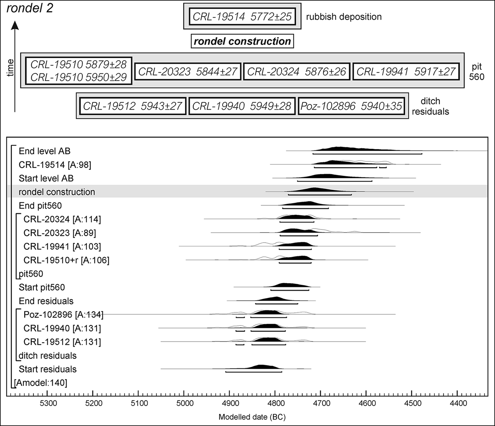
Figure 7. Praha-Krč: model setting and probability distributions for radiocarbon dates linked with rondel 2. Modelled in OxCal v4.4, using the IntCal20 calibration curve (Bronk Ramsey Reference Bronk Ramsey2009; Reimer et al. Reference Reimer2020) (figure by V. Vondrovský).
In order to highlight potential differences in dating, separate chronologies were constructed for the inner and outer ditches of rondel 1 (Figure 8). The model for the outer ditch builds on just three dates (CRL-19938, CRL-19939 and CRL-20325) from the western sector (Amodel = 140%). Dates CRL-20122 and CRL-20123 were excluded, despite their mutual consistency and origin in the finds-rich layers AB and C (upper and middle), which correspond to deliberate deposition of rubbish and final ditch levelling. This was because these dates differ on a statistically significant level from CRL-19938, which was also extracted from level AB (see OSM3 and Table S5). Moreover, as these two dates also precede dates from level D (lower), we conclude that they are residual and probably result from disturbed non-rondel features, rather than bank erosion. The LBK residual material hitherto identified in levels AB are more recognisable examples of the same trajectory. Nonetheless, it should be noted that including CRL-20122 and CRL-20123 in the model would cause only a minor modification to the result (for consistency tests and alternative models, see OSM4). The model sets the outer ditch construction of rondel 1 at 4715–4584 cal BC (at 95% probability) or 4703–4640 cal BC (at 68% probability).
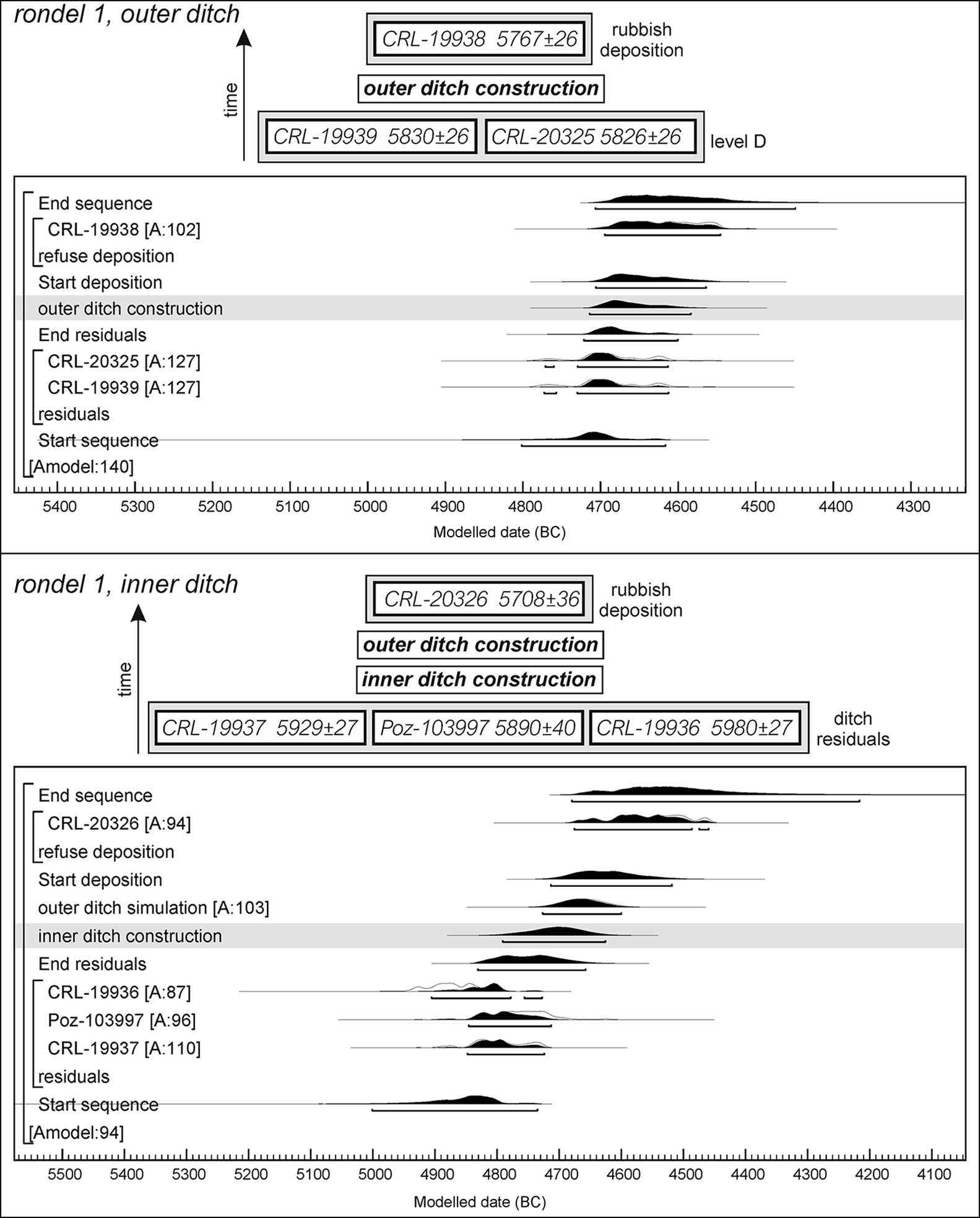
Figure 8. Praha-Krč: model settings and probability distributions for radiocarbon dates of rondel 1. Modelled in OxCal v4.4, using the IntCal20 calibration curve (Bronk Ramsey Reference Bronk Ramsey2009; Reimer et al. Reference Reimer2020) (figure by V. Vondrovský).
The model for the inner ditch of rondel 1 lacks a reliable representative sample of the ditch's upper level, because CRL-19935 from level AB (upper) clearly corresponds to earlier LBK activities. An initial phase of rubbish deposition, however, could be extracted from level C (represented by the CRL-20326 date), where various taphonomic processes occurred. This date is not chronologically consistent with other—presumably residual—dates obtained from levels C and D of the inner ditch (CRL-19936, Poz-103997 and CRL-19937). A further prior could be included in the model if we assume that the rondel ditches were gradually added over time (Stäuble Reference Stäuble and Schmotz2007: 174; Trnka Reference Trnka, Bertemes and Meller2012)—that is, the construction of the inner ditch should precede that of the outer ditch. The probability distribution for the inner ditch should therefore not exceed the time of the outer ditch. Based on these assumptions, the model provides a solid agreement index (Amodel = 94%) and sets the construction of the inner ditch of rondel 1 at 4792–4626 cal BC (at 95% probability) or 4744–4659 cal BC (at 68% probability).
Combining all of the above models, we argue for the contemporaneity of the two rondels at Praha-Krč, at least during some period of their existence. The probability distributions representing the period during which the ditches could have been dug overlap considerably for rondel 2 and the inner ditch of rondel 1, even at 68% probability (Figure 9). A succession of rondels is less probable. Although the wide probability distributions allow sufficient time for the construction of the rondels to have taken place successively, it should be noted that the lifetime of a rondel has been estimated to have spanned at least several decades (Petrasch Reference Petrasch1990: 457; Stadler et al. Reference Stadler2006: 66), which could bring the two rondels into contemporaneous use. The difference between rondel 2 and the outer ditch of rondel 1 (−46 to 145 years at 95% probability; −1 to 91 years at 68% probability) may point to successive construction and use, but, given that the outer ditch of rondel 1 represents its terminal stage, it must have been preceded by a single ditch phase. The interval between the two phases should be considered, even though it cannot be specified.

Figure 9. Praha-Krč: probability distributions for ditch construction (A) and intervals between ditch constructions (B). The chronology of the late SBK period in Bohemia is also displayed in diagram A (dates based on Řídký et al. Reference Řídký2019: tab. 9.1). Modelled in OxCal v4.4, using the IntCal20 calibration curve (Bronk Ramsey Reference Bronk Ramsey2009; Reimer et al. Reference Reimer2020) (figure by V. Vondrovský).
Discussion
Many previous chronological studies of rondels have been influenced by the incorporation of residual material resulting in early dates for the emergence and a longer duration of the rondel phenomenon (see Bertemes & Northe Reference Bertemes, Northe, Bertemes and Meller2012: 22; Řídký et al. Reference Řídký2019: 133). Our chronological analysis of Praha-Krč uses a formal modelling framework to address this problem. The results indicate that the rondels were constructed during the second half of the forty-eighth and the first half of the forty-seventh centuries BC and that they were most probably used contemporaneously. The rondels at Praha-Krč were built at least several decades after the appearance of the late SBK Culture in Bohemia during the early forty-eighth century BC. This phase is characterised by new styles of pottery decoration, the use of exotic raw materials and changes in house construction. The rondels should therefore be considered as a consequence of, rather than a trigger for, these socio-economic developments.
Rondel construction, especially the larger examples, would have demanded a considerable input of labour (Lobisser & Neubauer Reference Lobisser and Neubauer2005), requiring a large group of people from several neighbouring settlements to gather repeatedly at a specific time and place to participate in a collective endeavour. This process coalesced individual residential groups into a single entity that was concentrated around the rondel site, which became a focal point of social interaction (Petrasch Reference Petrasch1990: 498–512; Neubauer Reference Neubauer and Schmotz2007: 225–28). But following this narrative, how should we interpret the existence of multi-rondel sites? Simultaneous use of multiple rondels at a single site challenges the conventional idea of individual Neolithic communities formed predominantly according to spatial principles—i.e. around distinct and autonomous settlements or monuments.
A one-to-one correspondence between residence and social grouping is just one extreme on the spectrum of possible socio-spatial forms of organisation (Hillier & Hanson Reference Hillier and Hanson1984: 256–61). The opposite extreme is that of fully translocal societies, in which members of one residence group have more diverse social relations and interact to a high degree with individuals from other residence groups (Furholt Reference Furholt2017). The co-existence of multiple rondels of different forms at the same site leads us to consider the possibility of a degree of translocality among rondel-building communities. The ambitious task of constructing a rondel was an ideal platform for the formation of what Wenger (Reference Wenger1998) calls ‘communities of practice’. These types of fellowship connect members based on a common interest or goal, and the desire to share knowledge and possible solutions; place of origin is unimportant for membership of such groups. We admit that such translocal groups may have been established before the construction of rondels and may have had roots in, for example, kinship or reciprocity. Settlements where multi-rondel arrangements appeared may have been sites whose history or spiritual significance marked them out (Flannery & Marcus Reference Flannery and Marcus2012: 153–69), and which then attracted translocal communities to construct their rondels there, despite having to share the site with others (Figure 10).
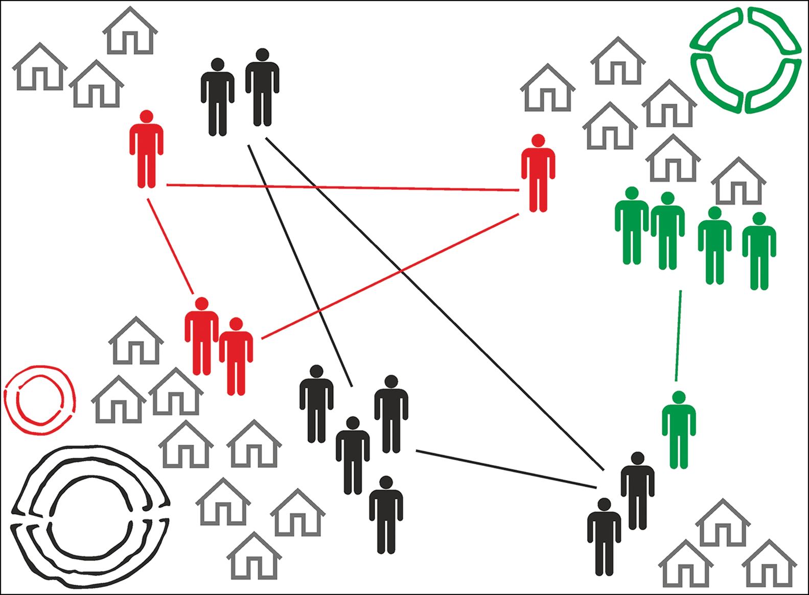
Figure 10. Socio-spatial model of rondel communities organised on translocal principles (adapted from Furholt Reference Furholt2017: fig. 1 by V. Vondrovský).
It is not easy to find support for the hypothesis of translocality beyond the evidence of the rondel architecture itself. Even for translocal rondel communities, we cannot assume that such aggregation crossed the boundaries defined by distinctive pottery decoration styles. Since the group members shared a similar cultural habitus, they are not easily distinguishable in the archaeological record. Extensive excavations, however, have revealed house pairs or clusters at settlements (Končelová & Květina Reference Končelová and Květina2015) and combinations of different burial rites at cemeteries (Zápotocká Reference Zápotocká1998: 60–62) associated with multi-rondel sites, which might also indicate the sharing of a single site by several social groups.
The essential elements of rondels spread unchanged across vast areas of Central Europe: a circular palisade or other wooden structure, which could be entered from several directions, surrounded by a bank and ditch. Beyond these basic conventions lay the potential for idiosyncratic architectural approaches. Differences can be observed between rondels found at single-rondel sites and, more strikingly, between those constructed in close proximity at multi-rondel sites. Our spatial analysis of these multi-rondel sites reveals the total size of the rondels and the diameters of the inner ditch to be the main distinguishing features, but the numbers of ditches and the numbers and positions of the entrances are also significant. As many of these attributes would need to be established before construction commenced and could not be later altered, it follows that the people who built the rondels intended to create distinctive enclosures from the start. Nonetheless, certain differences could conceivably have been introduced by subsequent, gradual changes to the initial layout, particularly by the addition of new ditches or the deepening existing ones, or through modifications to the entrances.
We contend that this behaviour reveals competition between communities involved in the construction of particular enclosures and that this rivalry should be assigned to the community as a whole. The individual role of established community leaders as the initiators of such a symbolic contest is debatable, since the archaeological record offers no evidence—beyond that of the rondels themselves—of any substantial social hierarchy in rondel-building societies. Indeed, monumental architecture is equally likely to emerge within a group of people through purposeful actions driven by collective decision-making (Kowalewski Reference Kowalewski and Birch2013: 213–14; Řídký et al. Reference Řídký2019: 177–78). The engagement and resources that a group was able to mobilise were proportional to the monumentality and uniqueness of a rondel's form. Such a conspicuous consumption of energy and resources not only strengthened the internal cohesion of a community, but also reinforced its external status in inter-community competition (Trigger Reference Trigger1990). Large gatherings of people involved in rondel construction, ceremonies and feasting must have resembled a kind of performance (Thomas Reference Thomas, Gebauer, Sørensen, Teather and de Valera2020: 291) that was plausibly intensified by the spatial proximity of rondels at the same site. It was important to repeat these performances by maintaining or enlarging a rondel to confirm the group's status. Of course, failures and losses of momentum were inevitable in some cases. The outer ditch of rondel 1 at Praha-Krč, for example, remained discontinuous and relatively shallow, suggesting that the work was abandoned before the ditch was completed.
Even if there was a close succession of rondels at some multi-rondel sites, this could nonetheless tell a similar story of inter-group rivalry. An old enclosure might be replaced by a new one to demonstrate a community's ability to accomplish yet another, often more ambitious, task. The successive construction of rondels could also stem from the rapid aggregation of dispersed communities. This process has been well documented by Bánffy et al. (Reference Bánffy2016) for the eastern cultural complex, c. 4700 BC. Also, the greater distances between neighbouring rondels of eastern regions recorded in our study may indicate larger settlement areas and, hence, larger communities (Figure 2). The sudden growth of previously small populations may have ignited social tensions, and it may be that the later rondels reflect the presence of incomers who symbolically asserted their rights in competition with resident populations.
The role of rondels, however, should not be reduced entirely to the sphere of inter-group rivalry. We do not assume, like Oliva (Reference Oliva2004: 516–18) for example, that the sole significance of rondels was the performative, collective labour entailed in their construction, or that use of the enclosed spaces was marginal. Rondels were built first and foremost as arenas. Despite the differences noted above, the basic uniformity of the enclosures shows that their meaning was widely understood across the different cultural regions of Central Europe. The concept of rondels and the activities that took place within them established an important framework for ‘rondel society’, in which the prestige of particular groups could be negotiated within a mutually comprehensible framework.
Conclusions
The structural and chronological analysis of multi-rondel sites offers a nuanced perspective of these enclosures and the social structure of the communities who constructed them. In particular, it allows us to identify characteristics that are not apparent when studying single-rondel sites. We contend that, while rondels had a role to play in coalescing Neolithic society in Central Europe, their integrative potential should not be overstated. While participation in rondel construction and the ritual activities that took place within these enclosures undoubtedly reinforced the cohesion of those involved, the study of multi-rondel sites indicates that these practices did not affect the integrity of previously or newly established groups organised on translocal principles.
Our interpretation of the social role of rondels has been prompted by scrutiny of the chronology of multi-rondel sites; this has allowed us to develop a novel approach to Bayesian modelling of dates derived from different depositional contexts and suggests the contemporaneous use of multiple rondels at some rondel sites, such as Praha-Krč. This leads us to propose that competition between communities may have been a factor in the construction of rondels. Since the monumentality and uniqueness of each rondel at the multi-rondel sites embodied the prestige of the community that built it, these enclosures provided an arena for inter-group rivalry to flourish. The energy invested in this competition may have mitigated, or at least redirected, more serious social tensions. This strategy nonetheless maintained a dichotomy between ‘us’ and ‘them’, sometimes perhaps between neighbours, thus sowing the seeds of eventual disintegration. Thus, the idea of the rondel, shared by communities across Central Europe, was paradoxically also the very feature that prevented the creation of a new identity that could have overcome social division—a scenario that might find echoes in other periods and regions characterised by similar shared monumental complexes.
Acknowledgements
We are grateful to Dagmar Dreslerová and the anonymous reviewers for their helpful comments and to Peter Demján for his advice on Bayesian modelling.
Funding statement
This article was supported by the Research, Development and Operational Programme of the Ministry of Education Youth and Sports of the Czech Republic (OP RDE, MEYS), under the project Ultra-trace Isotope Research in Social and Environmental Studies using Accelerator Mass Spectrometry (Reg. No. CZ.02.1.01/0.0/0.0/16_019/0000728). It was also supported by the Grant Agency of the University of South Bohemia (GAJU 039/2018/H) and a Gerhard Bersu Scholarship awarded by Pro Archaeologia Saxoniae.
Supplementary material
To view supplementary material for this article, please visit https://doi.org/10.15184/aqy.2022.75.


