


Introduction
Sixteenth-century descriptions of the Inca emphasise the impressiveness of the state's capacity and the breadth and intrusiveness of its social policies (e.g. Toledo Reference Toledo and Urteaga1920 [1553–1575]; Cieza de León Reference Cieza de León, De Onis and von Hagen1959; Garcilaso de la Vega Reference Garcilaso de la Vega and Livermore1989; Sarmiento de Gamboa Reference Sarmiento de Gamboa and Markham2010 [1572]). Generally, archaeological research confirms the significant impact of the Inca on their subject populations, but also demonstrates great variation in Inca governance strategies and the varied degrees of direct rule imposed (e.g. D'Altroy Reference D'Altroy1992; Hastorf & D'Altroy Reference Hastorf, D'Altroy, D'Altroy and Hastorf2001; Burger et al. Reference Burger, Morris, Matos Mendieta, Pillsbury and Quilter2007; Malpass & Alconini Reference Malpass and Alconini2010). The Inca-sponsored mitmaq policy relocated up to one-third of the total subject population, and is a prime example of direct state intervention. Nevertheless, most characterisations of Inca control—and the control of pre-modern states in general—are limited to a single scale of analysis of direct vs indirect control. In reality, assessing the operation of state power demands investigation at multiple scales and of multiple facets of the daily life of subject populations. The case of Yanawilka, a community of resettled non-Inca agriculturalists, demonstrates that even in an area of deep Inca state penetration, and under an intrusive social policy such as the mitmaq (see below), there could be enclaves where subject populations could remake local landscapes for their own purposes.
The mitmaq was a state resettlement policy intended to create docile social landscapes (Mumford Reference Mumford2012: 106–109). Subject populations were relocated from their homelands to support the Inca through farming and craft production (D'Altroy Reference D'Altroy1992: 188). These mitmaqkuna made up an estimated one-quarter to one-third of the total population subject to Inca control (D'Altroy Reference D'Altroy2014: 373). The mitmaq was socially intrusive: it relocated groups of people far from their home landscapes, which, in the Andes, were paramount in the foundation of a community's history, identity and ritual (Rowe Reference Rowe, Collier, Rosaldo and Wirth1982; Hyslop Reference Hyslop1990; Herrera Reference Herrera, Kohring and Wynne-Jones2007). The local landscape contained the pacarinas, or origin beings, of the community. Pacarinas were a class of huacas, or sacred beings, responsible for the creation and ongoing fertility of the community; they could be rivers, animals, plants, lakes, springs, caves, rocky outcrops, boulders or stones (Duviols Reference Duviols1967: 20). Relocation from such landscapes meant that one could no longer make regular offerings to the original pacarinas, bringing possible calamity to the community (Hyslop Reference Hyslop1990). According to sixteenth-century cleric and extirpator of idolatry, Cristóbal de Albornoz (Duviols Reference Duviols1967: 20), the Inca recreated the pacarinas of the mitmaqkuna's home landscapes in their new settings, presumably to encourage them to leave their places of origin. The Inca allegedly also offered special privileges to the mitmaqkuna to make the relocation more palatable (Cieza de León Reference Cieza de León, De Onis and von Hagen1959: 57; Cobo Reference Cobo and Hamilton1979 [1580–1657]: 90).
Despite the profound reorganisation of labour and landscapes that the creation of the mitmaqkuna class implies, we understand little about the daily lives of the mitmaqkuna, or even the appearance of their settlements. We lack, for example, any archaeological evidence with which to assess if and how the Inca and the mitmaqkuna recreated the pacarinas of their home landscapes. As Albornoz did not specify how the Inca recreated the pacarinas of the mitmaqkuna, Hyslop (Reference Hyslop1990: 107) has suggested that moveable pacarinas, such as small stones and perhaps even pieces of the original pacarinas, were used in these recreations. New archaeological work at a probable mitmaqkuna settlement known as Yanawilka near the Inca provincial capital of Vilcashuamán, however, suggests that home landscapes might have been recreated through the identification and use of suitable surrogate features found in the new landscapes where the mitmaqkuna were settled. While the general location of these new settlements reflected the interests of the Inca state, the mitmaqkuna appear to have exercised some autonomy in settlement planning and the selection of the specific location, allowing the recreation of sacred spaces evocative of their former homes. In contrast to Albornoz's characterisation of complete state control over settlement location and the recreation of pacarinas, the evidence from Yanawilka suggests a degree of negotiation between the Inca and the mitmaqkuna.
Archaeological research on mitmaqkuna settlements
Despite extensive ethnohistorical discussion of the mitmaqkuna and their apparent numerical prevalence across the Inca Empire, we know little of their daily lives (Haun & Cock Carrasco Reference Haun, Cock Carrasco, Malpass and Alconini2010). Few mitmaq settlements have been confidently identified and archaeologically researched. Identifying mitmaq settlements in the archaeological record is challenging for a number of reasons, including the difficulty of establishing the motives for the foundation of new settlements of non-local peoples; not all new sites were mitmaqkuna communities, although their material cultures may have been indistinguishable (Alconini & Malpass Reference Alconini, Malpass, Malpass and Alconini2010: 281, 293–95; D'Altroy Reference D'Altroy2014: 376–77; Hu & Shackley Reference Hu and Shackley2018: 214). While settlement planning, hybridised ceramic styles and non-local architectural forms have been used to identify several possible mitmaqkuna settlements (Trimborn Reference Trimborn and Trimborn1981; Covey Reference Covey2000; Makowski Reference Makowski2002; Rossen et al. Reference Rossen, Planella, Stehberg, Malpass and Alconini2010), there is a lack of conclusive evidence that they were established under the mitmaq policy. Ethnohistorical sources and archaeological surface survey suggest that Milliraya, near the northern shore of Lake Titicaca, may be another possible mitmaqkuna colony. No confirmatory excavations, however, have been conducted here (Spurling Reference Spurling1992).
Based on a combination of ethnohistorical, archival, radiocarbon dating, ceramic and architectural evidence, recent work has identified the site of Yanawilka as a probable mitmaqkuna settlement (Hu Reference Hu2016). AMS radiocarbon dating and the presence of diagnostic Inca-style pottery sherds placed beneath the foundation stones of domestic structures securely place the origins of Yanawilka in the mid fifteenth century AD, following the arrival of the Inca in the area (Hu & Shackley Reference Hu and Shackley2018). The earliest and latest radiocarbon dates do not overlap in the 95 per cent confidence intervals, suggesting that Yanawilka was inhabited for several generations (Hu Reference Hu2016: 50–51). Sixteenth-century Spanish ethnohistorical records indicate that, on their arrival, the Inca almost completely depopulated the province of Vilcas Huamán before resettling it with mitmaqkuna (de Carabajal Reference de Carabajal, de la Espada and Carreras1965). Colonial-era land titles list Yanawilka as belonging to a mitmaqkuna group called the Conde (Hu Reference Hu2016: 47), who, according to ethnohistorical sources, were allies of the Inca (Salas Reference Salas2002). The absence of Old World artefacts, ecofacts or structures suggests that Yanawilka was abandoned prior to, or shortly after, the arrival of the Spanish. The Conde, however, continued to use the surrounding agricultural lands during the early colonial period (Piel Reference Piel1995: 175–76).
Space syntax analysis of path structure
Hillier and Hanson's (Reference Hillier and Hanson1984) use of space syntax analysis to understand the social logic of space provides an appropriate method for the identification of structurally central and integrated areas within the settlement of Yanawilka (cf. Hanson Reference Hanson1998; DeMarrais Reference DeMarrais, D'Altroy and Hastorf2001; Morton et al. Reference Morton, Peuramaki-Brown, Dawson and Seibert2012). A comparison of the connectivity and integration of paths of movement and lines of visibility, and their proximity to certain architectural and public spaces, may reveal important aspects of community organisation. The space syntax proxy for these lines of movement and visibility are known as axial lines; these can be generated using DepthMapX to represent the path structure of a settlement and to calculate the connectivity and integration of each axial line. The connectivity of an axial line represents the number of other lines that intersect it; the integration of an axial line is a measure of how easy it is to arrive at every other line within the overall structure, approximating the degree of foot traffic (Hillier et al. Reference Hillier, Penn, Hanson, Grajewski and Xu1993). Axial line analysis can identify which path segments were structurally most central and integrated within a site, and can indicate the degree of formal settlement planning (DeMarrais Reference DeMarrais, D'Altroy and Hastorf2001). Circuitous and irregular axial line networks generally indicate settlement growth by accretion, rather than by central planning. In formally planned settlements, the axial lines with the highest integration and connectivity are concentrated around the core of the settlement. Multiple clusters of axial lines with high integration and connectivity are reflective of undifferentiated internal settlement organisation (DeMarrais Reference DeMarrais, D'Altroy and Hastorf2001: 132–37). By examining the axial lines with the highest integration and connectivity in relation to the functions of the spaces surrounding them, we can assess the degree to which the social space of a settlement was formally planned and whether this was intended to serve the needs of the inhabitants, or of outsiders, such as representatives of the Inca state (Ferguson Reference Ferguson1996: 101).
Choosing a new settlement location
While the choice of location for the new settlement reflects the security and economic interests of the Inca state, the specific landscape features of the site point to the mitmaqkuna's concern with ritual aspects of social organisation. Two particular features of Yanawilka's location served the economic purposes of the Inca state. First, at 3050–3080m asl, Yanawilka is located in the temperate Pomacocha/Vischongo valley, with easy access to four major ecological zones: quechua (2400–3200m asl), suni (3200–3600m asl), puna (3600–4300m asl) and high puna (4300–4800m asl) (Pulgar Vidal Reference Pulgar Vidal1946; Cama Salazar & Paucarima Cerón Reference Cama Salazar and Cerón2005: 26–28). In the fertile quechua zone immediately surrounding Yanawilka, a wide variety of crops can be grown, including maize (Zea mays), beans (Phaseolus vulgaris), quinoa (Chenopodium quinoa), cañihua (Chenopodium pallidicaule), potato (Solanum tuberosum), ulluco (Ullucus tuberosus), oca (Oxalis tuberosa), mashwa (Tropaeolum tuberosum) and tarwi (Lupinus mutabilis) (Hastorf Reference Hastorf1993). Second, Yanawilka was close to several major Inca settlements, including the royal estate at Pumaqocha-Intihuatana and the important provincial capital of Vilcashuamán, and just 300m from a major Inca road (Figure 1). The presence of agricultural tools and the lack of evidence for craft specialisation suggest that the mitmaqkuna of Yanawilka were farmers tasked with supplying the nearby Inca settlements; both Pumaqocha-Intihuatana and Vilcashuamán have extensive storage units for food and other provisions (Santillana Reference Santillana2012). At the same time, Yanawilka was sufficiently distant and modest in size (around 60–70 structures) so as not to pose any significant threat to the Inca settlements, in the event of a sudden revolt by the mitmaqkuna. Yanawilka was also visible from the main Inca road, which was frequently patrolled by agents of the Inca state (Cieza de León Reference Cieza de León, De Onis and von Hagen1959: 127).

Figure 1. The geographic setting of Yanawilka with anisotropic travel times using the r.walk function in QGIS (figure by D. Hu).
The precise choice of site location, however, was not only a reflection of state economic and security interests. The topography of Yanawilka stands out in the local landscape and points to ritual significance. Yanawilka includes two large rocky outcrops, each situated at the top of a low hill (Figure 2), around which the vast majority of the domestic structures are located. Unsuited to agricultural use and well drained during the rainy season, the site represents a good location for settlement, although the nearest of several water sources is approximately 250m distant. This suggests that the distinctive characteristics of Yanawilka's landscape eclipsed the advantages of an immediate source of fresh water.

Figure 2. Aerial photograph of the site of Yanawilka with the two major rocky outcrops, called ‘Yanawilka’ and ‘Saqapayoq’, indicated (figure by D. Hu).
The toponym ‘Yanawilka’ refers to the more prominent rocky outcrop of the eastern hill. A ‘Yanawilka’ in early colonial Quechua refers to a ritual specialist at the lowest tier in the Inca ritual hierarchy and also signifies any person who was old and wise, with expertise in medicinal plants (Jiménez de la Espada & de Santillán Reference Jiménez de la Espada and de Santillán1879: 163, 182; Hyland Reference Hyland2003: 160–62). Today, the western hill and surrounding area are known as ‘Saqapayoq’, a name of uncertain meaning. For native Andeans, rocky outcrops were commonly sacred places (huacas) and pacarinas (Hyslop Reference Hyslop1990: 102–108). By choosing the two largest rocky outcrops as the anchors on which their new community would grow, the mitmaqkuna created new community-level pacarinas under the watchful eye of the Inca. The latter, however, probably did not choose the specific pacarina surrogates for the mitmaqkuna, as the rocky outcrops show no signs of Inca-style intervention. Moreover, the Yanawilka rocky outcrop features a cave, within which human remains were interred. Caves, as openings into the earth and netherworld, were widely considered to be pacarinas by native Andeans (Herrera Reference Herrera, Kohring and Wynne-Jones2007: 174). The presence of these ancestors, who were crucial to the ongoing fertility of the community, reinforced the status of the Yanawilka outcrop as a probable pacarina. Given the spatial symmetry of the two rocky outcrops, the mitmaqkuna also probably considered the Saqapayoq outcrop as a pacarina. Today, these two outcrops remain sacred for members of the Pomacocha community, who make regular offerings.
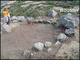
The mitmaqkuna may have also created household-level pacarinas. The site of Yanawilka was unusually rocky, comprising limestone formations of distinctive shapes and sizes. The surrounding landscape, however, is less rocky and more suitable for agriculture. Most of the structures (44 of 63) at Yanawilka—which were all apparently domestic—incorporate a large natural stone or boulder into the foundations or the walls (Figure 3). The Inca often deliberately incorporated rocky elements of the landscape into their structures as ‘origin stones’, or foundation stones, to graft their buildings onto the life force of the landscape (Dean Reference Dean2010: 82). The inhabitants of Yanawilka may also have purposefully incorporated boulders and large stones of the landscape into their domestic structures.

Figure 3. Example of a domestic structure with a boulder incorporated into the wall and foundation (photograph by D. Hu).
Moiety and settlement structure
The two low hills with their rocky outcrops provided the basis for an ideal landscape through which to recreate a moiety social organisation—specifically, the spatial clustering of structures into two main groups, one on each hill, and the presence of a central public area between the two.
Moiety organisation was ubiquitous in the ancient Andes, and duality was evident in the beliefs, material cultures and social structures of the Inca and most of their subject populations (Pärssinen Reference Pärssinen1992; Zuidema Reference Zuidema, Dover, Seibold and McDowell1992; Moore Reference Moore1995). The moiety division in the late pre-Hispanic Andes was often known in Quechua as hanan, or ‘upper’, and hurin, or ‘lower’, among other dualisms such as female/male and right/left (Arnold & Hastorf Reference Arnold and Hastorf2016: 137). Hanan was associated with the ‘right’ direction and hurin was associated with the ‘left’ (Garcilaso de la Vega Reference Garcilaso de la Vega and Livermore1989: 44–45). The capital of the Inca Empire, Cuzco, was divided into hanan and hurin, with hanan Cuzco being higher in elevation than hurin (Ossio Acuña Reference Ossio Acuña, Urton and Hagen2015: 122). In the case of Yanawilka, hanan and hurin are consistent with these directional associations. From the vantage point of the Inca road (north of Yanawilka), the hanan moiety is both to the right and higher in elevation than the hurin moiety (Figure 4). At Yanawilka, the hanan moiety is on the western side and the hurin moiety is on the eastern side. The organisation of settlements into upper and lower moieties was consistent with the Inca policy of requiring non-Inca settlements to imitate the form of Cuzco (Garcilaso de la Vega Reference Garcilaso de la Vega and Livermore1989: 45). It is difficult to discern whether the mitmaqkuna were already traditionally organised into a moiety structure prior to their relocation, or whether this was an Inca imposition; the lack of Inca design elements, such as quadrangular public areas and straight paths, in Yanawilka's planning, however, suggests the former.

Figure 4. Panoramic view of Yanawilka from the Inca road looking south (photograph by D. Hu).
The structures at Yanawilka are grouped in two clusters, one centred on each hill and the ritual focus provided by each rocky outcrop (Figure 5). The outcrops, located at almost opposite ends of the site, demonstrate symmetry. The construction of retaining walls around them—as often the case with huacas—suggests that the inhabitants of Yanawilka venerated these outcrops (e.g. McEwan Reference McEwan, Meddens, Willis, McEwan and Branch2014). Each cluster comprises a roughly equal number of structures, with the upper moiety (Saqapayoq) consisting of approximately 35 and the lower moiety (Yanawilka) around 40, although poor preservation means that only 27 and 35 structures can be identified with certainty in the upper and lower moieties, respectively.

Figure 5. Topographical structure of Yanawilka in relation to the distribution of structures (figure by D. Hu).
Each hill hosts its own public space, with an additional roughly circular central public area located between the two hills. The latter is divided by a wall into slightly higher and lower areas. The presence of multiple public spaces suggests social groupings beyond the basic moiety division (Figure 6). At the community level during the Inca period, many Andean peoples were divided not only by hanan and hurin moieties, but also by a quadripartite ceque, a system defined by lines radiating from a centre point (Zuidema Reference Zuidema1964; Hyslop Reference Hyslop1990). At least three small caves at Yanawilka served as burial sites, suggesting the presence of multiple social groups (Figure 6). These groups may have aggregated from different communities in the Conde homeland; alternatively, they may have developed over the multiple generations of inhabitation at Yanawilka. Radiocarbon dates and ceramic seriation suggest that the two excavated structures in the lower moiety were established after at least one of the structures from the upper moiety (Hu Reference Hu2016: 51, 151). The moiety structure, therefore, may have developed organically as a result of the expansion of the community onto the adjacent hill. Either way, the Inca did not seem to have a direct hand in settlement planning.

Figure 6. Map of Yanawilka including the locations of grave sites G1, G2 and G3 (in red text) (figure by D. Hu).
Mitmaqkuna autonomy in settlement planning?
Two lines of evidence suggest that it was the mitmaqkuna, not the ruling Inca, who were primarily responsible for the local planning of Yanawilka. First, Yanawilka lacks the hallmarks of Inca settlement planning, such as quadrangular structures with trapezoidal niches, trapezoidal public spaces and straight roads (Hyslop Reference Hyslop1990). The absence of an Inca administrative core and of canonical Inca architectural features suggests less intense Inca intervention at Yanawilka (D'Altroy Reference D'Altroy1992; DeMarrais Reference DeMarrais, D'Altroy and Hastorf2001; Meddens & Schreiber Reference Meddens and Schreiber2010).
Although Inca presence is hard to discern solely on the basis of architectural style, the state used distinctive architectural motifs, such as well-fitted masonry and trapezoidal niches, to project imperial power (Hyslop Reference Hyslop1990). The only structure at Yanawilka with recognisably Inca-style masonry is a small quadrangular structure located between the moieties, away from the central public area. Unlike the typical irregular stone walls of the rest of the Yanawilka settlement, this structure preserves several courses of relatively well-fitted stone (Figure 7); the interior space also measures only 5m2—much smaller than the average Yanawilka building. Inca-style structures, however, varied considerably across the Empire, making identification difficult. The masonry of the possible Inca-style structure at Yanawilka resembles that of the nearby Inca site of Pumaqocha-Intihuatana (Figure 8). This similarity and the uniqueness of the structure at Yanawilka suggest that it may represent an Inca bureaucratic presence. The lack of an Inca administrative core, however, points to a less direct style of rule than at, for example, the nearby communities of the Sora ethnic groups, which provide greater evidence for Inca-style architecture in the administrative core (Meddens & Schreiber Reference Meddens and Schreiber2010).

Figure 7. Location and aerial photograph of the anomalous Inca-style quadrangular structure (figure by D. Hu).

Figure 8. A comparison of the Inca masonry at the nearby Inca royal estate of Pumaqocha-Intihuatana (top) with the Inca-style structure at Yanawilka (bottom) (photographs by D. Hu).
The second line of evidence that suggests the mitmaqkuna, rather than Inca, were responsible for the planning of Yanawilka comes from space syntax axial line analysis. Presumably, axial lines with the highest integration and connectivity should pass through or close to the most important areas of communal activity at a settlement. At Yanawilka, the Inca-style structure and the central public area for communal and ritual activities are located in different parts of the settlement. Therefore, if the axial lines with the highest integration and connectivity pass near to the Inca-style structure, it might be argued that the settlement was planned to facilitate on-site Inca administration. If, on the other hand, these axial lines are more closely associated with the rocky outcrops or the central public area, and away from the Inca-style building, this may indicate that the planning of the settlement was not intended to facilitate direct Inca control. Although the central public area and the possible Inca structure are both similarly located between the moieties, the path segments near the possible Inca structure are not as connected and integrated into the overall path structure of the settlement as the central public space, which played an important role in the life of the community (Figure 9). Similarly, the next two most highly connected axial lines pass by the rocky outcrop of Saqapayoq (upper moiety) and one of the public areas of the upper moiety, leading to the rocky outcrop of Yanawilka (lower moiety).

Figure 9. Level of connectivity and integration of axial lines of the path structure at Yanawilka represented by the intensity of the red lines; the arrow points to the location of the Inca-style structure (figure by D. Hu).
The axial lines that pass near the Inca-style structure have higher than average integration values, reflecting the central location of the structure within the settlement, and allowing access to both moieties with equal ease. These lines, however, also demonstrate low connectivity, which may reflect the unembedded nature of Inca governance at Yanawilka (Figure 10 & Table 1). Hence, despite its central location within the settlement, the structure appears to have been purposefully positioned on a less connected offshoot, perhaps for more privacy. The small size of the possible Inca-style structure—combined with its isolation from other domestic structures and lack of connectivity in the network of paths at Yanawilka—suggests that the Inca did not play a significant day-to-day role in life at the settlement. Most probably, Yanawilka was occasionally visited by a low-ranking Inca administrator who did not live there full-time, as was the case in the mitmaqkuna colony of Miliraya (Spurling Reference Spurling1992: 386).

Figure 10. Chart of integration and connectivity of axial lines of the path structure at Yanawilka. The axial lines passing by the central public area are represented by blue inverted triangles; axial lines passing by the Inca-style structure are represented by red squares (figure by D. Hu).
Table 1. Summary statistics of axial line analysis showing the high connectivity and integration of the central public area compared to the path segments near the Inca-style structure.

Yanawilka therefore displays little evidence for Inca intrusion. The mitmaqkuna themselves were probably responsible for its spatial organisation and architecture. The planning of the settlement catered to the specific communal needs of the mitmaqkuna by recreating the local sacred landscape of their former home. Although the specifics of that former home landscape are unknown, the importance the mitmaqkuna attached to the distinctive landscape of Yanawilka suggests that they were almost certainly referencing their former landscape in their new home. Environmental factors such as drainage and the conservation of agricultural space must also have been significant in the choice of the site. The two hills and the prevalence of natural boulders and small caves, however, also made Yanawilka an attractive place to evoke the mitmaqkuna's former home in an idealised form. At the same time, the Inca were able to monitor the settlement and to enjoy the fruits of the mitmaqkuna's labour.
Discussion
If the Inca did not plan the settlement of Yanawilka or micromanage its daily affairs, it does not mean they employed limited control, but rather simply a lesser form of direct rule than experienced at other, more rebellious sites (e.g. the communities of the Sora people). The settlement location and spatial organisation of Yanawilka are consistent with cooperative or negotiated decision-making between the Conde and their Inca rulers (e.g. Wernke Reference Wernke2007, Reference Wernke2013). The Inca may have tolerated or encouraged a moiety structure because they themselves subscribed to moieties. Furthermore, by tolerating a bipartite social structure within a settlement, the Inca were able to replicate in microcosm their policy of divide-and-control of the wider landscape—as seen through the mitmaq policy (Acuto Reference Acuto2012).
Yanawilka provides an understanding of the varied kinds of privileges that the Inca allegedly afforded the mitmaqkuna. The inhabitants of Yanawilka did not have access to exotic goods, such as metals, abundant obsidian and elaborate pottery (Hu & Shackley Reference Hu and Shackley2018). This differs from the possible mitmaqkuna settlement of Pueblo Viejo-Pucara, where prestige items, such as spondylus shells, precious metals and fine pottery, were prevalent (Makowski Reference Makowski2002). At Yanawilka, privileges took the form of access to fertile agricultural lands and a degree of daily autonomy. The pattern at Yanawilka also contrasts with Inca policy in the hostile context of frontier areas. In the area of modern north-western Argentina, for example, the Inca made great efforts to reorder native sacred landscapes and settlement patterns for the purposes of control (Acuto Reference Acuto2012; Acuto et al. Reference Acuto, Troncoso and Ferrari2012; Acuto & Leibowicz Reference Acuto, Leibowicz, Alconini and Covey2018). The Inca occupation of the Soras and Andamarca Lucanas peoples revealed that the Inca were more likely to install administrative buildings in the settlements of rebellious groups (Meddens & Schreiber Reference Meddens and Schreiber2010). Thus, the allied status of the Conde mitmaqkuna (Salas Reference Salas2002) was fully consistent with the lack of a significant administrative presence at Yanawilka.
The case of Yanawilka shows how negotiation and some local autonomy were important, even in contexts of significant state intrusion such as the mitmaq policy. The Inca may have torn the mitmaqkuna from their homelands, but the latter were able, partially, to recreate those original landscapes on their own terms. The conquistador Francisco Pizarro observed that the mitmaqkuna generally “have long since converted the lands and towns where they live into their native place” (Mumford Reference Mumford2012: 31). Probably, therefore, the recreation of home landscapes played a role in remaking sacred attachments to new landscapes, even if these were ultimately contained within the Inca strategy of divide and rule.
Conclusions
The community (or mitmaqkuna) relocated by the Inca to Yanawilka recreated the social space of their homeland through the careful choice of a location with natural features that evoked the pacarinas of their original landscape and that permitted the recreation of the traditional moiety community structure. These social and ritual concerns superseded other considerations, such as the need for an on-site source of water. Inca imperial rule differentially affected various aspects of social life at Yanawilka. Even though the inhabitants of the settlement had autonomy in some aspects of settlement planning and daily life, other activities, such as the external trade of obsidian, may have been limited by the Inca for the purposes of control (Hu & Shackley Reference Hu and Shackley2018). The archaeological evidence can therefore be used to question assumptions about the uniformity of state power in relation to social and economic groups such as the mitmaqkuna. Space syntax analysis, in conjunction with a variety of other archaeological lines of evidence, demonstrates the varying levels of Inca state intrusion in different aspects of the daily lives of its subject populations.
Acknowledgements
The author thanks Christine Hastorf, Julie-Anne Bouchard-Perron, Adam Webb and two anonymous reviewers for comments that improved the article. Research funding was provided by the John L. Simpson Memorial Research Fellowship, the Fulbright-Hays Doctoral Dissertation Research Abroad Fellowship, a Wenner-Gren Dissertation Fieldwork Grant (#8265), the Stahl Fund and a Ford Foundation Dissertation Fellowship. Excavations at Yanawilka were carried out under the Ministry of Culture-Peru Resolución Directoral No 085-DGPC-VMPCIC/MC.


