


Introduction
Agricultural planning is not limited to terracing, field boundaries and hydraulic engineering. As a collective social practice, agriculture also requires the formalisation of a corporate coordination system, using devices such as calendars and ceremonies, to relate the farming communities to the specific spatial and temporal organisation of the given socio-economic and political context in which this practice is taking place (Haudricourt Reference Haudricourt1987). Such socio-cultural systems related to agriculture may be materialised through a variety of architectures and built environments to structure the collective agricultural practice. This was evidenced, for example, by Ingold (Reference Ingold1993) in his well-known analysis of Brueghel's painting The Harvest. Hence, agricultural areas are more than a set of planned infrastructures for the production of crops: they constitute landscapes whose forms are not only the ‘footprint’, but also the ‘matrix’ of farming practices and the associated symbolic systems (Berque Reference Berque2015).
The Inca Empire, which extended its hegemony over the Andes during the fifteenth and sixteenth centuries AD, was fundamentally agrarian. While food production for subsistence across the heterogeneous Andean environment was achieved principally at the communal scale, the ritual crops, such as maize (Zea mays) and coca (Erythroxylum coca), were managed by the Empire, as they formed the basis of its political economy and diplomacy (Murra Reference Murra and Murra2012 [1960]). In this context, locking the provinces into an imperial agricultural economy involved regular ceremonies intended to perform the largely symbolic imperial redistribution of the tribute, which subjugated communities generally fulfilled via corvée labour, such as agriculture work, rather than by the supply of goods (Wachtel Reference Wachtel and Murra2012 [1974]).
Here, we report the analysis of an archaeological structure whose characteristics resemble aspects of a specific form of Inca architecture documented in sixteenth- and seventeenth-century chronicles. We argue that the structure could have been related to the planning of a ritual built environment intended for the exercise of imperial agricultural policy. We document in detail and analyse this circular stone building, the niches and windows of which suggest that the structure may have been used for astronomical observations for determining the timing of sowing—a period of great political significance in the Inca agricultural calendar (Ziolkowski Reference Ziolkowski2015).
The archaeological site of Incahullo in the Altos de Arica region
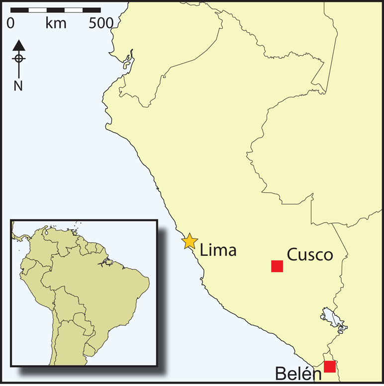
The site of Incahullo (‘corral of the Inca’ in the Aymara language) acquires its name from the ruined stone architecture on a fluvial terrace of the Valley of Belén, in the south-central Andes (Figure 1). This valley is located in the upper Azapa Basin, 3000m asl in the Sierra region, at the centre of the Andean western transect, on the edge of the Atacama Desert (Figure 2). During colonial times (sixteenth and seventeenth centuries AD), this highland region was known as the ‘Altos de Arica’, and was populated by a multi-ethnic mix of Cole farmers and Camanchaca fishermen from the coastal valleys, along with Carangas farmers and shepherds from the Altiplano (Vasquez de Espinosa Reference Vasquez de Espinosa1948 [1629]; Bouysse-Cassagne Reference Bouysse-Cassagne and Cook1975). These mixed populations and their overlapping settlement patterns reflect the multi-zonal complementarity of Andean vertical ecology, characterised by intense interactions between the Altiplano and the Pacific coast (Saintenoy et al. Reference Saintenoy, Ajata, Romero and Sepulveda2017).

Figure 1. The Incahullo site (indicated by dashed line) in the Valley of Belén (figure by T. Saintenoy).

Figure 2. Location map of the Valley of Belén in the Altos de Arica (figure by T. Saintenoy & F. González).
In this context, ethno-historical evidence shows that the Altos de Arica played a central role in the geopolitics of the Inca imperial agrarian economy, as the region kept important stores of maize destined for export to different parts of the Altiplano (Rostworowski Reference Rostworowski1983–1984; Durston & Hidalgo Reference Durston and Hidalgo1997). The Sierra region was an extensive agricultural landscape: satellite imagery shows that today, on average, 10 per cent of the land under 3900m asl is terraced, and up to 30 per cent in the Valley of Belén. The aridity of the region does not permit rain-fed agriculture; annual rainfall over the past 40 years has averaged only 150mm, with rain concentrated in three months of the year (from December to February), and with irregular inter-annual variability, including recurrent dry years (Morales et al. Reference Morales, Christie, Villalba, Argollo, Pacajes, Silva, Alvarez, Llancabure and Soliz Gamboa2012; Saintenoy et al. Reference Saintenoy, González and Uribe2019).
The agro-pastoral territory of the Altos de Arica—currently in a process of abandonment due to the rural exodus during the twentieth century—has its origins in the Late Intermediate Period (eleventh–fifteenth centuries AD). At the beginning of the second millennium, a widespread village-based settlement pattern developed across the sierra region, with associated evidence for extensive agricultural planning, including elaborate hydraulic systems for water redistribution between watersheds (Saintenoy et al. Reference Saintenoy, Ajata, Romero and Sepulveda2017). During the fifteenth and sixteenth centuries, this territory was incorporated into the Inca Empire, and thus was integrated into its system of socio-territorial control based on a network of imperial infrastructures distributed across the different ecological levels between the Altiplano and the Pacific coast (Saintenoy et al. Reference Saintenoy, González and Uribe2019).
Inca occupation of the Altos de Arica concentrated in the Valley of Belén, the largest and best-watered valley in the upper Azapa Basin. The imperial presence was manifested through the construction of built environments using intrusive Inca-style architecture in the largest settlements of the valley (Dauelsberg Reference Dauelsberg1983; Saintenoy et al. Reference Saintenoy, González and Uribe2019). Among these, the settlement of Incahullo, located in the middle valley close to Huaihuarani, the largest residential settlement of the valley, presents the most significant local evidence for Inca architecture and planning.
The site of Incahullo extends to more than 2ha and incorporates 50 structures, although disturbance by recent agricultural development obscures the original extent and morphology of the settlement. Among the probable Inca structures are two callancas (large halls), some smaller quadrangular buildings, possible colcas (storage structures), a stone chullpa (mausoleum) and—the focus of the current study—a circular stone building (Figure 3). In 2014, five test pits were opened to investigate these different structures. These excavations, however, provided no significant results, as the subsoil of the site, even within the structures, had been heavily disturbed by recent agricultural activity. As a result, no stratigraphic information of interest was recorded, and only a small quantity of cultural remains—four decorated ceramic sherds and a few camelid bones—was recovered.

Figure 3. Plan of the Incahullo settlement (figure by T. Saintenoy, F. González & K. Rodríguez).
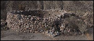
The best-preserved structure at the site is a circular building, 6.5m in diameter, with well-made ignimbrite stone walls surviving to over 1.8m in height (Figure 4). The building has 12 internal niches and two windows. The niches, each measuring approximately 0.2 × 0.2m, form a horizontal, irregularly spaced row around the inner wall. The windows are vertical openings, measuring 0.3 × 0.1m; one is oriented to the east, and the other to the west. The uniqueness of these features among the vernacular architecture of the Altos de Arica combined with the planning of the settlement and presence of various Inca architectural forms suggest that the circular structure is an intrusive Inca form.

Figure 4. Architecture of the Incahullo sunturhuasi (figure by T. Saintenoy).
The place name refers to the recent use of the building as a pen for livestock, as evidenced by the 0.2m-deep layer of animal dung on the surface, and by the modification of the wall section to create a new entrance, in a fashion typical of goat pens in this region. This, however, was probably not the original function of the structure, for in Inca architecture, the circular shape is rare and usually reserved for colcas, although these do not typically feature the combination of windows and niches found here (Morris Reference Morris1967; D'Altroy & Hastorf Reference D'Altroy and Hastorf1984; Sillar & Dean Reference Sillar and Dean2012). The presence of this unusual arrangement of windows and niches within the circular structure at Incahullo suggests that it had a special function.
In 1615, the chronicler Guaman Poma de Ayala published a drawing of the main square of Cusco—once capital of the Inca Empire. The foreground of the illustration shows a circular structure with windows, labelled with the Quechua word sunturhuasi or ‘round house’ (Figure 5). An anonymous sixteenth-century chronicler points out that the sunturhuasi was part of a ceremonial structure known as usnu (which also consisted of a holy well, a gnomon and possibly a monumental platform), from which astronomical observations were made (Zuidema Reference Zuidema and Burga1989 [1980]). This complex of ceremonial architecture does not survive, and its location within the square and the existence of any further distinguishing features, such as niches or stuccoed walls, are unknown.

Figure 5. Representation of the Cusco main square, with the sunturhuasi in the forefront (from Guaman Poma de Ayala Reference Guaman Poma de Ayala1615: 329).
To our knowledge, only a few examples of Inca circular buildings have been identified as anything other than colcas. The example most similar to the Incahullo structure is found at the site of Unu Urqu in the Valley of Vilcanota, in the Inca imperial heartland. There, on a promontory above the valley floor, stands an Inca architectural complex built around a carved monumental outcrop, which includes a circular building, 7m in diameter, with windows, niches and various openings. The structure's orientation could be related to solstice observations, according to our preliminary inspection of the map published by Squier (Reference Squier1974 [1877]). This analogous building at Unu Urqu invites us to consider two hypotheses concerning the function of the circular Incahullo structure: did it function as a colca or as a sunturhuasi? While a storage function is consistent with the site's central location within the maize-growing areas of the Valley of Belén, recent agricultural disturbance makes it difficult to evaluate this hypothesis archaeologically. Instead, here we propose to investigate the possible use of the structure for astronomical observations that might indicate a possible interpretation as a sunturhuasi. To achieve this, we performed several measurements, observations and simulations of the astronomical phenomena related to the structure's location, orientation and morphology.
Methodology
To evaluate the potential use of the circular building at Incahullo for astronomical observations, we acquired a precise topographical model of the site, with particularly high-resolution coverage of the architecture of the circular structure. These topographical data form the basis of an assessment of the visual relationship between the structure and the surrounding landscape using a positional astronomy model, which is able to simulate celestial movements in relation to the orientation of the building during its use in the fifteenth and sixteenth centuries.
Topography of the site and its architecture
The three-dimensional (3D) topographical model of the site and its architectural complex was generated by means of an aero-photogrammetric survey, itself anchored to a digital elevation model (DEM) of the wider region. The aero-photogrammetry was processed from 165 nadir photographs complemented by oblique photographs to improve the modelling of wall elevations. The site topographical model has a 3cm/pixel resolution covering an area of 3ha, combined with a 1.5cm/pixel photorealistic orthoimage. This local topographic bundle was then georeferenced to a regional data bundle covering the upper Azapa Basin featuring an Advanced Elevation series Digital Globe product, with a resolution of 4m/pixel and a 2m vertical relative accuracy, covering an area of 1000km2. This regional dataset was generated by photogrammetry of sub-metre resolution satellite imagery (WorldView-2 sensor), and calibrated using ground control points tied to the Chilean Military Geographic Institute's geodetic network.
The 3D model of the circular building was generated through terrestrial photogrammetry using 180 photographs of the structure's interior and exterior. The accuracy of the model has a root-mean-square error of 4mm, measured using six control points corresponding to Photoscan software targets (arranged on the inner wall), whose relative XYZ coordinates were determined using a total station. The installation of a central stake within the structure, and the arrangement of scales and targets inside and outside prior to aerial and ground photogrammetry, allowed for the precise placement of the 3D model of the building within the topographical model of the site.
The multi-scale digital model of the circular building, the wider site and the surrounding region provides the necessary geodetic precision and accuracy to undertake astronomical simulation. Before exporting the model to the Stellarium software to perform this simulation, we simplified the 3D model's topology of the circular structure using Blender software to reduce the number of faces from approximately 3 300 000 to 7200, while retaining the necessary details of the windows and niches (Figure 6).

Figure 6. Three-dimensional modelling of the Incahullo sunturhuasi (figure by M. Crespo).
Astronomical modelling
Along with the topography of the site and the circular structure, the astronomical simulation also requires accurate modelling of the horizon. The horizon, as observed from the centre of the structure, was generated from the regional Advanced Elevation series DEM, using the ArcGIS Spatial analyst toolbox. The resolution of the horizon was defined as 0.05°, which is equivalent to a reference point every 9m for the farthest horizon.
The accuracy of the azimuthal orientation of the structure with the horizon was evaluated from measurements taken on-site with a total station, based on seven mountain peaks on the surrounding horizon. Magnetic declination correction was carried out according to the database of the National Oceanic and Atmospheric Administration; the absence of ferromagnetic material at Incahullo allows for high confidence in the accuracy of the readings. A final check was undertaken by means of our own direct astronomical observations at the June solstice and the two annual equinoxes.
Finally, the 3D models of the circular building and the horizon were combined in Stellarium, using the Scenery 3D tool environment (Zotti Reference Zotti2016). The behaviour of the simulation fits well with our on-site observations of the Sun's movement over the horizon and of its light entering through the windows of the circular structure. Given the accuracy of the photogrammetric topography and the roughness and irregularity of the structure's architecture, however, it is necessary to allow for a 24-hour margin of error within the lighting model at the maximum of each equinox (Figure 7).

Figure 7. Astronomical orientation of the Incahullo sunturhuasi (figure by M. Crespo, T. Saintenoy & A.C. González-García).
Results
To characterise the ways in which the building relates to the surrounding landscape and to assess its astronomical potential, we first examine the landscape ‘in visu’, that is the ‘visualscapes’ from the building, and, second, the illumination phenomena ‘in situ’, that is the lighting behaviour inside the building—both defined by the orientation of the windows in relation to the Sun (Roger Reference Roger1998).
Building orientation and landscapes in visu
One of the two windows opens towards the east, facing uphill, where the horizon, approximately 10km distant, corresponds to the mountain range bordering the Altiplano. The other window, oriented to the west, faces a nearby horizon (approximately 0.7km distant) corresponding to a promontory of Mount Laguane, the location of the site of Huaihuarani.
From a geographic perspective, both windows frame significant pre-Hispanic places. The eastern window is oriented towards the Huanacalave pass, which is crossed by one of the main roads connecting the sierra to the Altiplano. This pass is marked by a 7m-diameter apacheta (cairn), next to one of the few highland lakes in the region. The western window looks towards the rocky summit of Huaihuarani, whose stone walls are still visible from Incahullo. Huaihuarani comprises the remains of the largest residential settlement of the region, in which the Inca Empire built a ceremonial landscape around the rocky summit (Saintenoy et al. Reference Saintenoy, González and Uribe2019).
It is notable that, for two periods of 20 days per year (approximately 2–22 April and 21 August–9 September), the western window faces the setting Sun behind the Huaihuarani rocky summit. The orientation of the centre of the eastern window is outside of the solar range, although the Sun at the June solstice could be observed by looking diagonally through the window, a few minutes after its rise. The same diagonal perspective would have allowed observation of the moonrise at the northern major lunar standstill (the northernmost rise of the moon, occurring for a couple of years every 18.6 years), as well as the Pleiades a few minutes before dawn on the June solstice, an event later known to be used for weather and planting forecasting in the Andes (Orlove et al. Reference Orlove, Chiang and Cane2000).
In situ lighting phenomena
In addition to framing landscapes in visu, the windows would also have allowed direct sunlight to fall within the structure. This phenomenon is notable a few minutes before the Sun sets behind the rocky summit of Huaihuarani, when a beam of light would have been projected through the window and then moved over the course of 40 minutes from its initial appearance on the floor at approximately the centre of the structure up the inner face of the opposite wall to just below the row of niches (Figure 8).

Figure 8. Astronomical phenomena in visu and in situ. Dates shown in DD/MM/YYYY format (figure by M. Crespo, T. Saintenoy & A.C. González-García).
The integrated 3D model of the building, combined with the horizon, allows comprehensive simulation of the movement and temporal behaviour of the illumination of the structure, which we had been able to observe empirically on only three specific dates. The simulation shows that solar lighting through the western window occurs during two periods of the year, for a duration of approximately two months each time. It also shows variability in the appearance of the illumination during these two periods, which can be described as a sequence of three phases:
1) When the illumination is projected on the floor.
2) When it is projected on the opposite wall, a period that begins and ends at dates close to the equinoxes.
3) When it climbs the wall towards the niches. Due to the size and height of the lighting produced by the most direct orientation towards the sunset through the window, this phase corresponds to the greatest intensity of the lighting phenomenon within the building.
3D simulation further reveals that a small lighting effect on the floor would have also occurred through the eastern window at sunrise on the June solstice. Similarly, the full moon near to the December solstice on the years close to a major lunar standstill would have produced this effect. These two phenomena, however, have not been verified by direct observation.
Discussion and interpretation
In his recent work on the Inca calendar, Ziolkowski (Reference Ziolkowski2015) distinguishes two types of astronomical observations: the first relates to the public staging of the skyscape and imperial cosmology, and the second corresponds to accurate calendrical computations made by specialists. The architecture of the Incahullo building would have allowed both types of observation to be made. While the framing of the sunset on Huaihuarani apparently has a performative character (by merging the imperial celestial divinity with a local sacred mountain in the same visualscape), the capture of the phenomenon of illumination highlights the computational potential of horizon astronomy. In both cases, the astronomical function of the building seems predominantly related to the computation and performance of the imperial agricultural calendar.
The Incahullo sunturhuasi and the making of an imperial agricultural landscape
In the modern Altos de Arica region, as at Cusco, the year's first planting of maize occurs in August and September (Figure 9). According to the Inca calendar recorded by Guaman Poma de Ayala (Reference Guaman Poma de Ayala1615: 253), August was designated as the chacra yapuy quilla, which translates as ‘tillage month [moon]’. The chronicler (Guaman Poma de Ayala Reference Guaman Poma de Ayala1615: 253) details that this was the month for “going back to work”, and that the Inca made “lots of celebration […] across the Kingdom” for this purpose (Figure 10). At the Inca capital, the start of this key period in the imperial agricultural calendar was determined by observing the setting of the Sun between two columns towering over the western horizon, as seen from the main square, which also featured the circular house called sunturhuasi.

Figure 9. Local agricultural calendar (after ethnological survey data gathered by T. Saintenoy) (figure by T. Saintenoy).

Figure 10. August: the time for sowing (from Guaman Poma de Ayala Reference Guaman Poma de Ayala1615: 250).
The data gathered concerning the astronomical potential of Incahullo's circular structure suggest that it may have been based on Cusco's sunturhuasi and intended to perform similar functions. Specifically, we propose that a sunturhuasi at Incahullo would have formed a central stage for the ritual performances related to the imperial planning of agricultural activities in the Valley of Belén.
In support of this hypothesis, it should first be noted that, beyond the morphological similarities with the Cusco sunturhuasi, the dimensions of the Incahullo structure correspond to those of the only known ethno-historical description of an Inca precision astronomical device. Its author, Sarmiento de Gamboa (Reference Sarmiento de Gamboa2001 [1572]: 236), writes that
to know precisely the time of sowing and harvesting and never get lost, [the Inca] did put in a high mountain to the East of Cusco four sticks, set apart from the other as two yardsticks [varas], and in the heads of them two holes, where the Sun entered as a watch or astrolabe.
Notably, two yardsticks, or approximately 1.8m, corresponds roughly with the distance between the niches that mark the ends of the inner illumination of the putative sunturhuasi at Incahullo.
Second, it is noticeable that the two periods of illumination within the structure correspond to key periods of the agricultural calendar: the sowing and harvesting of maize, the main resource of the imperial political economy. In this context, it seems significant that the period of greatest intensity of illumination on the wall—during August and September—corresponds to the proposed calendar by Ziolkowski (Reference Ziolkowski2015) for the sowing period celebration, called the Guayara feast. Beginning around 17 August, this period would have lasted approximately 20 days, although the exact date is uncertain, due to a lack of archaeological evidence. In fact, Ziolkowski (Reference Ziolkowski2015: 373–75) suggests that the precise date of this ceremony could have varied depending on the phase of the moon.
Third, the interpretation of the Incahullo structure as a possible sunturhuasi is consistent with the settlement's location in the middle of the maize-growing lands, within the vast imperial territory of the Valley of Belén. Furthermore, one of the agricultural sectors of the middle Belén Valley, located close to Incahullo has inherited the name ‘Colcapata’. Although Colcapata is a common name, it may be significant in this context, as it echoes the name of the Inca storehouses (colcas) referred to in the Tasa de La Gasca colonial archive (Rostworowski Reference Rostworowski1983–1984). Further, Colcapata also evokes an eponymous plot of land in Cusco, which was the main theatre of the Guayara feast where the Inca and senior officials performed the first planting of maize each year. This was also intended to re-enact the historical memory of the Empire's foundation (Garcilaso de la Vega Reference Garcilaso de la Vega1976 [1609]; Bauer Reference Bauer1996).
Finally, it is notable that the rocky summit of the Huaihuarani site was built as a sacred landscape and ceremonial space of restricted access, where maize was also stored (Saintenoy et al. Reference Saintenoy, González and Uribe2019). The observation of the Sun above the summit at Huaihuarani may, in fact, have served a similar function in initiating the celebration period at Incahullo, as did observations between the two monumental pillars at Cusco (Ziolkowski Reference Ziolkowski2015). In summary, the arguments presented here concerning the astronomical potential and location of the possible sunturhuasi at Incahullo all point towards a ritual function related to the imperial political economy of maize production.
Astronomical potential of the lightning phenomenon in the sunturhuasi
While some ethno-historical accounts refer to Inca light-and-shadow astronomy—predominantly describing buildings featuring windows, niches and/or installations such as gnomons and metal discs that were used to mark and produce light effects—there is still little corroborating archaeological evidence. The most recent research, conducted at the sites of Intimachay and Inkaraqay in Machu Picchu, has documented architectural structures for precise astronomical observations associated with lighting phenomena at significant dates in the Inca calendar (Ziolkowski Reference Ziolkowski2015). While no traces of specific observational instruments have been found, a set of engraved vertical lines at Intimachay evoke the testimony of Sarmiento de Gamboa (Reference Sarmiento de Gamboa2001 [1572]: 236) mentioning the observation of light and shadow by means of marks engraved or painted on walls and floors as “an artifice of annual observation”. Although we lack empirical evidence for how the observations of light and shadow were made, it is clear that the capture of light at specific dates for projection on a surface increases the computational potential—in comparison with simple horizon astronomy—for recording periods of calendrical importance.
Further interpretations of how the observations of lighting phenomena were performed within the Incahullo structure remain speculative. A basic hypothesis could propose that the walls were stuccoed, as was common in Inca architecture and was indeed the case at the other probable sunturhuasi at Unu Urqu (Squier Reference Squier1974 [1877]). Stuccoed walls would have provided a surface on which to mark the position of light at certain dates of special interest. Moreover, we could tentatively propose that the transition of light under the niches marks a sequence of approximately 5–15–5 days—a sequence that could have served to structure a festive period, such as the celebration of planting, involving a series of rituals performed at different dates during August and September. Finally, we could perhaps also propose that the capture of light at different dates within the structure could have served to calibrate the lunisolar calendar during March and April, which probably corresponded to the period for the intercalation of an additional month every three years (Ziolkowski Reference Ziolkowski2015).
In summary, the Incahullo circular structure may have functioned as an astronomical device that allowed the observation of distinct celestial phenomena for the identification of specific dates in the Inca agricultural calendar.
Conclusion
Our examination of the architecture, surrounding landscape and astronomical potential of the Incahullo circular structure, with its unusual configuration of windows and niches, reveals multiple analogies between this building and the Cusco sunturhuasi. This suggests that the Incahullo structure may represent a provincial reproduction of an architectural model found in the Inca capital. Indeed, we might consider that the rarity of the sunturhuasi model in the archaeological literature may not discard a hypothetical widespread use of this architecture across the Inca Empire: for instance, its Indigenous politico-ceremonial function could have made it a privileged object for the extirpation of idolatry during colonial times (Duviols Reference Duviols2008 [1971]).
The astronomical analysis of the Incahullo structure, using both ethno-historical information about the Inca calendar and the archaeological and geographical data concerning the late pre-Hispanic Valley of Belén, suggests that the sunturhuasi served a ritual function connected with the imperial political economy of maize production. In addition to marking significant periods of the agricultural calendar, the Incahullo sunturhuasi could also have facilitated the hegemonic reproduction of Inca cosmology, combining, for instance, the main imperial celestial divinity with a local sacred mountain in the same visual landscape.
A full exploration of this complex combination of cosmological performance and accurate calendrical observations through an astronomy of light-and-shadow effects would require extensive excavation of the structure and the surrounding site, with the aim of identifying surviving elements used for such observations, such as gnomons and stucco.
Overall, this Inca case study contributes to our knowledge of the challenges of timekeeping and its social performance for the agricultural policy of ancient empires. A number of analogies can be identified across several other global regions and time periods. Egypt and China, for instance, present evidence that resembles the Inca example documented here. In twenty-seventh-century BC Egypt, the tie between the timing of agricultural tasks and the flooding of the Nile was incorporated into the calendrical system. Belmonte and Shaltout (Reference Belmonte and Shaltout2005) suggest that some of the small step pyramids in the Nile Valley could have been built to signal the annual flooding of the Nile, and calibrate the civil calendar, through their systematic orientation to the rising of Sirius in the night sky. Across Imperial China during the Ming Dynasty (fourteenth to seventeenth centuries AD), a number of towers and gnomons were erected to keep track of time, informing both the widespread performance of the ritual calendar and the organisation of tax collection (Shi Reference Shi and Ruggles2015). All of these examples reinforce the fundamental role of astronomically based timekeeping in the power strategies of ancient empires, along with the performative instrumentalisation of skyscapes for their political economies.
Acknowledgements
Archaeological research at Incahullo and in the Valley of Belén was funded by the Mission archéologique Arica-Belén of the French Ministry of Europe and Foreign Affairs, and by the Fondecyt 11121665 project. Research activities were authorised by the Consejo de Monumentos Nacionales of Chile, in collaboration with the Junta de vecinos de Belén, the Comunidad indígena de Belén, and indigenous cultural associations Chachawarmi and Wakmanta Paqariy. Ruben Santos, Federico González and Katherine Rodriguez kindly contributed to fieldwork. Archaeoastronomical analysis and simulation were funded by MSCA 800617 RoadNet_Andes. Finally, we wish to thank Peter Frost and the two anonymous reviewers for their careful revision of the manuscript.


