


Introduction
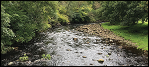
In 1801, the 78-year-old William Hutton set off on foot to explore the remains of the Roman frontier in northern Britain now known as Hadrian's Wall. By his own account, this was a return trip of some 601 miles, and he was not therefore a gentleman easily dissuaded from his purpose. But when, on his journey along the Wall, he reached Willowford, Hutton faced a problem. Before him lay the River Irthing—but no bridge—and a steep climb up the opposite bank:
I had this river to cross, and this mountain to ascend; but did not know how to perform either. I effected a passage over the river by the assistance of stones as large as myself, sometimes in, and sometimes out [of the water]” (Figure 1; Hutton Reference Hutton1990: 67).

Figure 1. The River Irthing at Willowford, where Hutton crossed in 1801 (figure by M.F.A. Symonds).
While Hutton's determination makes for an amusing anecdote in his memoir, his negotiation of the Irthing also illustrates the modern perception that rivers on the Tyne–Solway isthmus are more inconveniences than obstacles in their own right. Modern references to these rivers in Roman frontier scholarship primarily concern the bridges that spanned them; no sustained assessment of the locations and significance of potential Roman-period fords has been attempted to date.
An earlier visitor to the frontier preferred to see the rivers as constraints on movement. In 1599, the antiquary William Camden also took note of the Irthing. It was, however, the scope for north–south transit, rather than east–west movement along the Wall line, that drew his interest. Camden (Reference Camden1637: 800) believed it was within the 2.55km-wide bottleneck of land between the Irthing and the Tipalt Burn that northern enemies “made their passage into the Province […] in that place where they had free entrance by reason of no river in their way, into the inmore partes of England”. Camden's interest in movement presages the current interest of archaeologists in human mobility. This paradigm encompasses the totality of movement in the past, ranging from migration to household chores, and the interwoven meanings, power, identities and embodiments. Within communities, opportunities for movement are unevenly distributed, while new mobilities can precipitate social change by empowering new elites or engendering inequalities (Leary Reference Leary2014: 13; Leary & Kador Reference Leary and Kador2016: 3). In its purest form, mobility offers “an ensemble of freedom, opportunity, adventure and progress, and yet it was also a form of restriction” (Leary Reference Leary2014: 16). Although the contemporary mobile materialities and meanings of Hadrian's Wall have been explored (Witcher et al. Reference Witcher, Tolia-Kelly and Hingley2010: 109–12), less attention has been given to movement within the frontier zone during the Roman period. This article uses ford locations as proxies for concentrations of north–south movement across the Tyne–Solway isthmus, in order to highlight how the Roman military exploited mobility to consolidate its control over local communities.
The perspectives outlined above construct a duality: either the rivers were easily traversed or they served to channel movement from north to south into a single pinch-point in the landscape. The reality is more nuanced, as although river crossings provided an additional means of ingress, seasonal variations in flow periodically rendered passage at fords dangerous or impracticable, causing fatalities in more recent centuries (Linsley Reference Linsley and Archer2003: 208–209). Even a successful crossing could be nerve-wracking: an eighteenth-century traveller, for example, described the “infinite perils” of a South Tyne ford at Haltwhistle, and the value of local knowledge when using it (Hutchinson Reference Hutchinson1776: 12). In Britain, a general transition from fords to bridges is a feature of the tenth to twelfth centuries AD (Edgeworth Reference Edgeworth2011: 29), but map regression demonstrates that on the Tyne–Solway isthmus, bridges surpassed fords only in the last 150 years. Fords would certainly have been the commonest form of crossing during the Roman period, with the radiating routeways influencing wider landscape development by gathering settlements and associated facilities (see Edgeworth Reference Edgeworth2011: 122). The concomitant strategic value of fords makes knowledge of their locations essential for assessing competing modern interpretations of the purpose of Hadrian's Wall, which can be crudely characterised as regulating the peaceful movement of people or repulsing invading armies (see Breeze & Dobson Reference Breeze and Dobson2000: 40; Hodgson Reference Hodgson2017a: 160–66). Both interpretations also acknowledge the Wall as an effective means of deterring raiding. Assessing the physical and human geography of the frontier landscape, especially the interplay between fords and military infrastructure, permits reconsideration of these interpretations, with commensurate implications for understanding frontiers elsewhere across the Roman Empire.
Motion capture
Two river systems are prominent on the Tyne–Solway isthmus, with the watershed falling in the Tipalt–Irthing gap. There are five principal watercourses: the Tyne, North Tyne, South Tyne, Irthing and Eden (Figure 2). The North Tyne rises in the Cheviot Hills, while the source of the South Tyne lies far to the south in the Pennines. After flowing for around 69km and 68km respectively, the rivers meet to form the Tyne, which flows for approximately 56km before debouching into the North Sea (Ellwood Reference Ellwood2015: 70). The River Irthing rises on Paddaburn Moor and runs for around 58km before entering the Eden (Bidwell & Holbrook Reference Bidwell and Holbrook1989: 50); the latter flowing for approximately 130km from its Pennine source, before emptying into the Solway Firth. Local sea level in the Roman period remains a source of debate (see Jones Reference Jones, Sommer and Matešić2018: 784). A significant environmental affordance of the watercourses is an east–west corridor of valleys that bisect the isthmus, with intermittent north–south points of ingress. The rivers were probably invested with supernatural properties by some prehistoric and Roman inhabitants (Heslop Reference Heslop, Newton and Pollard2009: 3). Hence, crossing places were not only conduits for the flow of people through the landscape, but also woven into local belief structures as tangible interfaces with a powerful and capricious spiritual agent (Leary & Kador Reference Leary and Kador2016: 6). Modern Wall scholars also use the rivers to divide the frontier into three sectors for study: the eastern sector lies east of the North Tyne, the central sector between the North Tyne and Irthing, and the western sector west of the Irthing.

Figure 2. The Tyne–Solway isthmus, showing the principal watercourses alongside the Stanegate installations (courtesy of D.J. Breeze (Reference Breeze2019: 62), with amendments).
When Roman military units first entered the Tyne–Solway isthmus, they encountered populous farming communities. Archaeological excavations and surveys of the Northumberland coastal plain have revealed a network of enclosed farmsteads interspersed with smaller settlements, which potentially sustained a pre-Roman population of 10 000–15 000 over an area of approximately 675km2 (Hodgson Reference Hodgson, Hodgson, McKelvey and Muncaster2012: 209–10). Intensive pre-Roman settlement has also been detected on the Solway plain (Higham & Jones Reference Higham and Jones1985: 72), while scattered farmsteads occupied the marginal upland terrain in the centre of the isthmus (Huntley et al. Reference Huntley, Gates, Stallibrass, Symonds and Mason2009: 109–10). Although chronological uncertainties abound, particularly for these last two regions, it is credible that many sites existed at around the time of the Roman conquest. The isthmus is often viewed as the northern fringe of the territory of the Brigantes, a group who were administered as a civitas (self-governing community) in the Roman period. This polity, however, may have been aggregated from disparate political groups by Roman diplomacy to create a more compliant centralised entity (Haselgrove Reference Haselgrove2016: 472–80). There is certainly evidence that the local populations of the region included distinct social or political groups. Complex ties are evidenced during the Roman occupation by the establishment of a civitas Carvetiorum at Carlisle by AD 223 (Zant Reference Zant2009: 5), and smaller groupings of Textoverdi and Corionototae named on inscriptions (Collingwood & Wright Reference Collingwood and Wright1965; RIB 1695, 1142). The communities living in what became the frontier zone conceivably adopted differing responses to the Roman presence. It seems unlikely, however, that such variation can be credited to these groups being isolated by inchoate infrastructure.
While little is known about the scale or mechanics of Late Iron Age regional mobility, a network of routeways presumably existed. An Iron Age bridge is suspected at Piercebridge (H. Eckardt & P. Walton pers. comm.), for example, while the general course of a Roman-era road leading north towards the Tyne was seemingly used as early as the Neolithic (Vyner Reference Vyner2007: 69–77). The Iron Age farmsteads on the Northumberland coastal plain developed over several centuries (Hodgson Reference Hodgson, Hodgson, McKelvey and Muncaster2012: 206–11), and such settlements would have initiated and been sustained by connective movement (Leary Reference Leary2014: 4–5). Although the absence of locally minted coins and distinctive pottery eliminates two classic archaeological proxies for exchange, markets were presumably a corollary of this stable agricultural community, making acknowledged routeways that allowed passage through the landscape essential. This is equally true of the movement (or droving) of animals associated with transhumance, to which the region is well suited (see Stallibrass Reference Stallibrass and Hendriks2009). The natural east–west passage created by the river valleys of the isthmus presents an interface between upland and lowland agricultural regimes and the most convenient east–west corridor south of Tweeddale, some 60km to the north. From the north, the lateral valley corridor on the isthmus is most easily accessed via the east (Northumberland) and west (Solway) coastal plains, the North Tyne valley and the Tipalt–Irthing gap. Movement along these routes would help explain the presumably pre-Roman hillfort at Warden Hill, which commands the confluence of the North Tyne and South Tyne.
Despite the celebrated Roman aptitude for road building, the military also co-opted extant routeways (see Millett Reference Millett, Halkon, Millett and Woodhouse2015: 547–54). Dendrochronological dates from Carlisle indicate that a military garrison had been established directly south of the Eden by AD 72/73 (Zant Reference Zant2009: 413). In the east, a military base was founded on the north bank of the Tyne at Red House in the AD 70s, before being relocated to nearby Corbridge (Breeze Reference Breeze2006: 417–18). River crossings must have existed near these sites by the late first century AD, and quite possibly pre-dated the military occupation. The principal engineered Roman highway—now known as the Stanegate—that connected Carlisle and Corbridge may not have been completed until the early second century AD (Figure 2; Hodgson Reference Hodgson2017a: 34–35), so exploiting established routeways was presumably instrumental to control of the isthmus. If so, the extant physical infrastructure that facilitated the mobility of pre-existing local groups was subverted by an occupying force to support their military operations and thereby curtail the autonomy of those communities. Initially, the region was just another to be conquered as the military advanced northwards, but by AD 105, Roman forces had been compelled to return to the isthmus following a withdrawal from Scotland (Hartley Reference Hartley1972: 15). A subsequent proliferation of military installations is often viewed as a nascent Trajanic frontier (Figure 2). It is traditionally and probably anachronistically termed ‘the Stanegate system’, as the eponymous road most likely post-dates these new fortifications (Poulter Reference Poulter1998: 52–53; Hodgson Reference Hodgson2017a: 34–35). This arrangement endured into the early years of the reign of Trajan's successor as emperor: Hadrian.
Britain experienced serious conflict around the time of Hadrian's accession in AD 117 (HA, Hadrian 5.2; Magie Reference Magie1921), and construction of the Wall began in the early 120s. Its design positioned military installations according to predetermined spacings, which were seemingly insensitive to the landscape and anathema to the standard military practice of siting installations to derive maximum advantage from their surroundings (Symonds Reference Symonds2017: 108–109). This situation may explain why recent scholarship has often neglected the significance of the physical and human geography outlined above. The frontier comprised a curtain wall linking a chain of small military posts known as milecastles, positioned at the approximate intervals acknowledged by their name. These structures contained paired gateways permitting passage through the Wall curtain and housed garrisons unlikely to exceed 32 soldiers. Between the milecastles were pairs of turrets, resulting in manned posts every 495m or so along the Wall (Figure 3; Breeze & Dobson Reference Breeze and Dobson2000: 33–41). Although some flexibility was permitted, the greatest recorded discrepancy between a measured hypothetical mile separating two adjacent milecastles and the actual distance is 213m (Woolliscroft Reference Woolliscroft1989: 7); such rigidity of planning seemingly precluded meaningful flexibility to adapt the frontier to specific local conditions. The simplest explanation for this design is that it was judged to provide the optimal distance between military posts to detect incursions by groups small enough to be deterred or destroyed by milecastle and turret garrisons (Symonds Reference Symonds2010: 12; Foglia Reference Foglia2014: 37–38). A subsequent change of plan during the Wall's construction involved the addition of a series of forts holding far larger units of approximately 480–1040 men (Figure 3). Incorporating such concentrations of soldiers on the line of the Wall augmented the potential mobility of the frontier garrisons, possibly in response to an intensification of the threat facing the military (Symonds Reference Symonds2017: 131).

Figure 3. A schematic representation of the regular sequence of posts along Hadrian's Wall, before (A) and after (B) the addition of forts (after Breeze & Dobson Reference Breeze and Dobson2000: 151).
Hadrian's grand design delivered structured mobility on a scale unprecedented on the isthmus. The Roman military applied its overwhelming superiority in manpower and organisation to coordinate the complex logistics, including troop movements, new supply lines and the processing of raw materials, that the frontier works necessitated. Despite the unified frontier plan, however, the construction of the Wall produced a striking divergence in fabric. The western third of the Wall, commencing at the Irthing, was initially built of turf, earth and timber (hence the Turf Wall), with stone turrets; the eastern two-thirds of the Wall were built of masonry (the Stone Wall). This discrepancy has been attributed to varied factors, including a parlous security situation in the west requiring more rapid construction in turf (Graafstal Reference Graafstal2012: 124–26). The inference that the building programme was sensitive to local factors is supported by a quirk in the construction of the Wall curtain. It was initially built to a Broad Wall width of approximately 2.9m, but this was reduced at around the time the forts were added—perhaps after only three or four months of construction—to a Narrow Wall gauge of approximately 2.3m (Hill Reference Hill2006: 125). This allows us to reconstruct which elements were started early, revealing that military posts seemingly securing key routeways into the isthmus were typically fast-tracked and therefore apparently priority elements (Symonds Reference Symonds2005: 72–73). These include two milecastles that were well situated to control access to Tyne fords, marked on nineteenth-century maps, at Newburn and Hag (McCluskey Reference McCluskey, Sommer and Matešić2018: 161; Symonds Reference Symonds2019a: 107). Such evidence that river crossings merited early construction of posts highlights the potential significance of ford locations.
Once operational, the Wall appears to have initiated change among the local communities, although the picture remains partial. Dating evidence from three sites 7–12km north of the Wall near Newcastle indicates that these longstanding settlements were probably abandoned c. AD 120–140 (Hodgson Reference Hodgson, Hodgson, McKelvey and Muncaster2012: 191–214). A fourth site in the same region, Pegswood Moor, is 23km north of the Wall. There, a prehistoric settlement was seemingly reconfigured with a stock enclosure in the Roman period, while dating evidence again fits abandonment around the early second century AD (Proctor Reference Proctor2009: 70 & 99). Hodgson's (Reference Hodgson, Hodgson, McKelvey and Muncaster2012: 214–16) assessment of other excavated sites inland from the Northumberland coastal plain, but still north of the Wall, led him to propose “a fading away of traditional Iron Age society in the course of the second century”.
To the south of the Wall, a different trajectory is apparent. Durranhill and Low Crosby are located just to the east of Carlisle, and within 5km of the Wall. Activity at Durranhill seemingly continued from the prehistoric period into the fourth century AD, with an intensification in the second century AD. As is common in the region, however, there was no Iron Age material culture (Jackson Reference Jackson2016: 152–55, 172–73). First- to third-century AD pottery from Low Crosby has also been attributed to a rural settlement (Jackson et al. Reference Jackson, O'Meara and Stoakley2015: 35–37; Jackson Reference Jackson2016: 166–67).
In the east, 47km to the south of the Wall, a farmstead at Faverdale was modified in the mid second century AD with the addition of a structure resembling a Roman bathhouse, hinting at growing prosperity (Proctor Reference Proctor2012: 165–74). A study of rural settlement across the wider Roman province of Britain more generally has characterised the century following the development of the Tyne–Solway frontier as “the period of greatest opportunity for Roman Britain” (Smith & Fulford Reference Smith, Fulford, Smith, Allen, Brindle and Fulford2016: 410). As such, the abandonment of local settlement to the north-east of the Wall contrasts with general signs of heightened vitality to its south.
Finding fords
There are few studies of fords across the Roman Empire. The exceptions typically focus on artefacts discovered during dredging or canalisation operations; such objects probably include votive deposits made by those crossing the river (Sauer Reference Sauer2005: 96–98; H. Eckardt & P. Walton pers. comm.). Although none of the Tyne–Solway isthmus fords can be directly dated to the Roman period, historical accounts suggest that some were remarkably long-lived. In the east, Newburn was the lowest reliable fording point across the Tyne in the nineteenth century (Bruce Reference Bruce1889: 196), and two fords are marked at the settlement on the 1864 Ordnance Survey map sheet Northumberland XCVI (Ordnance Survey 1864). Scottish armies forded the river at Newburn in 1346 and 1640, emphasising its strategic significance (Ellwood Reference Ellwood2015: 86). An ancient crossing near here would explain why milecastle 10, on the approach to Newburn from the north, was prioritised. In the west, Roman antecedents have been proposed for the fords north of Burgh-by-Sands, which Edward I planned to use to invade Scotland in 1307 (Richmond Reference Richmond1966: 199–203); crossings still existed when the Ordnance Survey map sheet Cumberland XVI was surveyed in 1865 (Ordnance Survey 1868). A ford also appears on the same map 1.5km from the pre-Roman hillfort at Cargo to the north-west of Carlisle, while a Roman precursor near the nineteenth-century crossing beside Warden Hill has been deduced from the presence of temporary Roman camps (Hodgson Reference Hodgson2017b: 71). A further temporary camp lies adjacent to the South Tyne ford at Butt Bank. Elsewhere in Britain, at Wallingford, an example has been proposed of continuity in ford use from prehistoric times until a medieval bridge was established (Edgeworth Reference Edgeworth and Leary2014: 50), reinforcing the possibility that fords marked on nineteenth-century OS maps may have early origins.
Rivers are dynamic features and their movement can dislocate fords, which, in turn, can warp associated routeways and settlements (Edgeworth Reference Edgeworth2011: 121–22). The Roman bridge abutment at Willowford, which now lies marooned approximately 72m from the Irthing (Bidwell & Holbrook Reference Bidwell and Holbrook1989: 50), illustrates such channel mobility. Nevertheless, ford locations on the North Tyne have remained stable since detailed mapping began (Newson Reference Newson and Archer2003: 35–36), and the broad stretches suitable for crossings are probably a long-established environmental affordance. Fords are generally located close to pool-riffle sequences. Riffles are shallow, gravelly areas that can be passable during periods of lower and slower water flow. Although riffles best suited to fords may migrate a kilometre or so along the channel over the timespan under consideration here, these river features are unlikely to have changed location significantly, unless there have been major anthropogenic alterations to the river system or its catchment (A.M. Symonds pers. comm.).
Favourable river conditions, however, are only one prerequisite for fording, as suitable approaches are also essential. Sometimes, both of these conditions require human agency to establish and maintain a crossing. Naturally, passage can also be attempted away from a designated ford, as Hutton demonstrated. Nevertheless, the proposition that the broad stretches of river on the isthmus where fords existed in the nineteenth century could have also been suitable in the first and second centuries is viable, making their distribution worthy of consideration. To assess this, fords annotated on nineteenth-century Ordnance Survey maps in the vicinity of the Stanegate system and Hadrian's Wall were plotted in relation to known Roman infrastructure (Figures 4–6; see Tables S1–2 in the online supplementary material (OSM)). The Ordnance Survey maps were chosen because they offer an early source of detailed coverage presented to standardised specifications. At a few sites, perhaps most pertinently Chollerford, Hexham and Corbridge, fords had been replaced by bridges before the first Ordnance Survey maps were published. In order for the distribution maps to provide a reliable baseline, such earlier fords with less precise location data have been excluded. Naturally, examples superseded by bridges are just as likely to have Roman precursors, but factoring them in does not materially alter the pattern presented here. The North Tyne ford at Chollerford, for instance, only permitted east–west passage and was in any case near Broad Wall milecastle 27. Equally, priority milecastles 23–27 obstructed access to the Tyne fords at Hexham from the north, while Corbridge fort controlled the crossing there.

Figure 4. Nineteenth-century fords and the Stanegate installations (courtesy of D.J. Breeze (Reference Breeze2019: 62), with amendments).

Figure 5. Nineteenth-century fords, the Stanegate installations and priority milecastles on Hadrian's Wall (courtesy of D.J. Breeze (Reference Breeze2019: 62), with amendments).

Figure 6. Nineteenth-century fords, Hadrian's Wall and milecastles with internal areas over 350m2 (courtesy of D.J. Breeze (Reference Breeze2019: 78), with amendments).
The results reveal that elements of the Stanegate system align closely with nineteenth-century fords (Figure 4), suggesting the Roman intent to control river crossings. Assessing the distribution of military garrisons in relation to these crossings exposes divergences between the measures enacted in the western, central and eastern sectors of the isthmus. To the west of Throp, where the Stanegate sites intersect with the Irthing valley, all known military posts (apart from two towers) lie to the south of the rivers. Although a stretch of the Stanegate road does run north of the Eden and Irthing Rivers, the installations probably pre-date this highway (Hodgson Reference Hodgson2017a: 34–35). Indeed, its presence obscures a close relationship between the western Stanegate posts, in the form of forts, fortlets and towers, and the rivers or their valleys. To the east of Throp, by contrast, all certain Stanegate installations lie to the north of the South Tyne or Tyne rivers. As a long stretch of the Eden is devoid of fords, this could have led to it being viewed as a natural obstacle to movement by the Roman army. Judicious fortification may have seemed sufficient to transform the Eden and Irthing Rivers into a viable barrier. If, as seems probable, a fort belonging to the Stanegate system existed at Burgh-by-Sands (Hodgson Reference Hodgson2017a: 36), then all of the western fords are located within 4.5km of a military installation, and most are far closer. Indeed, the concentration of military posts between Brampton and Throp, as discussed by Hill (Reference Hill and Hill2002: 94), may represent a strategy to control a concentration of Irthing fords.
In the central sector of the frontier, Carvoran fort covered the eastern flank of the Tipalt–Irthing gap, while additional Stanegate posts regulated access to the South Tyne valley from the north. If the suspected early fort at Newbrough existed, then military installations again coincided with clusters of fords, albeit with garrisons occupying the northern approaches. On the Tyne, the situation differs once again as, despite the presence of fords, the only certain Stanegate installation is the early fort at Corbridge. A putative fort at Washing Wells is undated and poorly situated to control the Tyne valley (Breeze Reference Breeze2006: 416), while a postulated fort at Gateshead remains unproven (see Bidwell & Snape Reference Bidwell and Snape2002: 256–59). This apparently ‘light-touch’ approach to garrisoning strongly supports Hodgson's (Reference Hodgson, Hodgson, McKelvey and Muncaster2012: 212) contention that the Romans regarded the community populating the eastern sector as an “ally”. Accordingly, the three sectors of the frontier— western, central and eastern—demonstrate differing levels of control devised to address distinct human and physical geographies. In the east, mobility by local groups potentially continued undisturbed. The presence of most military posts in the central sector near the northern edge of the South Tyne valley implies that these measures primarily targeted those living in the uplands or travelling to them from either the adjacent lowlands or farther south. To the west, the foundation of military posts directly south of the rivers would split groups practising similar agricultural regimes on opposite banks. Such placement effectively subjected those crossing the rivers to military control, thereby constituting a more aggressive curtailment of the agency of local communities to move within a single valley. Overall, the arrangement on the isthmus resonates with Tacitus’ description of Roman policy on the Danube: “with [the Hermunduri] alone of Germans, business is transacted not only on the riverbank […] They cross the river everywhere without supervision […] we let other peoples see only our fortified camps” (Germania 41; Hutton & Peterson Reference Hutton and Peterson1970).
This interpretation of the Stanegate system of the early second century AD helps explain the construction sequence for Hadrian's Wall during the AD 120s. Indeed, the Wall effectively supplanted the rivers as the means of control, presumably because they proved too susceptible to unregulated movement. It is surely significant that the western sector once again stands out as different, with the decision to build in turf and timber facilitating more rapid construction. Extending the frontier to the east of Corbridge, with Hadrian's Wall ultimately terminating at Wallsend, was essential to controlling the wider isthmus, but it also posed a challenge. As the fords in that region were seemingly unsupervised during the Stanegate phase, there were no garrisons in the vicinity when Wall construction commenced. This situation was unique on the isthmus, and was seemingly addressed by fast-tracking work on at least three milecastles covering the northern approaches to the possible bridge at Newcastle and two sets of fords (Figure 5; Symonds Reference Symonds2019a: 107). Further priority milecastles in the central and eastern sectors of the Wall secured key northern entrances to the adjacent valleys via Dere Street, the North Tyne and the Tipalt–Irthing gap. Aiming to establish such small garrisons implies an expectation of low-intensity threats or non-combatants. Unfortunately, the absence of a comparative change in width for the turf elements precludes the possibility of identifying similar priority structures on the Turf Wall. One indication that fords were also significant here is provided by the replacement of the easternmost turf milecastles with larger stone versions during the Hadrianic period. As the addition of Wall forts generally decreased the importance of milecastles (Symonds Reference Symonds2005: 78), a localised requirement for bigger posts is conspicuous. Given that these large milecastles overlap with the concentration of Irthing fords immediately to the south (Figure 6), it seems probable that resistance along this stretch was aggravated by the obstruction of a transhumance route and, as an important local shrine probably lay 9.6km to the north at Bewcastle (Hodgson Reference Hodgson2017a: 123), possibly a pilgrimage route as well.
Discussion
Hadrian's Wall represents the epitome of a static line of fortification, yet mobility appears integral to understanding its intention and impact. While fords marked on nineteenth-century Ordnance Survey maps cannot be directly dated to the Roman period, the military build-up in the early second century AD is consistent with the existence of river crossings in these general areas. The recognition of fords as foci of movement indicates that this intensification of military control was initially geared towards restricting north–south movement across the isthmus, with Hadrian's Wall subsequently sealing off access to the east–west valley corridor as well. Undertaking early work on priority milecastles at critical entry points into the province, and indeed the overall concept for a cordon of small, dispersed Wall garrisons planned prior to the decision to add additional forts to the line of the Wall, are illuminating. Such garrisons would achieve little against large incursions. Instead, they suggest the anticipated threat of small groups—probably raiders and insurgents—that could be deterred or destroyed by modest numbers of soldiers. Clearly, this parsimonious military deployment would, however, most effectively immobilise non-combatants: farmers, traders, pilgrims, envoys and others who had moved across the isthmus for centuries.
There is a growing consensus that milecastle gateways were primarily intended for military use, rather than facilitating the cross-border movement of local groups (see Symonds Reference Symonds, Collins and Symonds2019b: 49). Whether passage was permitted at the Wall forts is a different matter, although the decision to route the two main north–south highways by way of bespoke gateways, rather than via the Wall forts, hints at a desire to keep through traffic separate from the military bases. If the locations where these two roads crossed the Wall were the principal transit points for local communities, their scope for such north–south movement was severely curtailed. The consequences of any such reduced mobility for Rome's putative allies to the north of the Wall on the Northumberland coastal plain were potentially disastrous, as evidenced by the apparent collapse of this group following the construction of the new barrier (Hodgson Reference Hodgson, Hodgson, McKelvey and Muncaster2012: 213–16).
The simplest explanation for the military control apparatus on the Tyne–Solway isthmus is that certain modes of mobility were judged a security threat when undertaken by specific groups. The juxtaposition of the Stanegate system with potential ford locations indicates that the most draconian measures were enforced in the west, with the garrisoning of river crossings suggestive of an attempt to impose a preclusive barrier. The apparent absence of similar measures in the east implies that north–south movement by resident populations here was not of equal concern. Such disparities presumably accelerated developmental differences between these communities, potentially destabilising some local elites: a phenomenon associated with new mobilities (Leary Reference Leary2014: 13). This technique was, however, unsatisfactory from a military perspective, perhaps in part because it incentivised those evading Roman controls to detour eastwards, simply displacing the problem. The very need for Hadrian's Wall testifies to the failure of the Stanegate system, while construction of the Turf Wall implies that, despite tighter security measures, the west remained troublesome. The establishment of modest garrisons at fixed intervals along the Wall indicates an attempt to nullify existing environmental affordances and to achieve military control by detecting and immobilising the transgression of small groups. Ironically, this concerted military effort to constrain movement could only be achieved by initiating a sustained surge in mobility in order to operate, secure and maintain the Wall, and provision its garrison. This activity potentially provoked violent responses from newly marginalised or excluded groups, whose livelihoods, agency, power structures and identity were threatened, conceivably prompting a sudden need for Wall forts. Nevertheless, comparing the apparently contrasting fates of local groups living beyond the Wall on the Northumberland coastal plain and those to the south of the Wall suggests that an effective division was ultimately imposed across the Tyne–Solway isthmus. Waging counter-mobility on this scale, however, was only achieved by redrawing the landscape with Hadrian's Wall.
The indications that pre-existing routeways are the key to understanding both the Stanegate system and the implementation of the design of Hadrian's Wall are likely to be of wider relevance to our perceptions of Roman military deployment. Many temporary or permanent installations associated with watercourses could have commanded longstanding crossings, either to protect lines of communication and supply, or to capitalise on the control that they afforded over the movement of others. If the attitudes of local communities and the natural features supporting their mobility were critical variables that shaped early second-century military measures to secure the Tyne-Solway isthmus, similar factors surely influenced the development of many other frontiers.
Acknowledgements
I am grateful to Hella Eckardt and Philippa Walton for discussing Piercebridge prior to publication; Andrew Symonds for sharing his riverine knowledge; my peer reviewers; and David J. Breeze for use of his maps.
Supplementary material
To view supplementary material for this article, please visit https://doi.org/10.15184/aqy.2019.216


