


Introduction
Large datasets facilitate the study of human activities on a continental scale, ranging from the analysis of ancient mobility (Prado et al. Reference Prado, Arroyo-Cabrales, Johnson, Alberdi and Polaco2015) to the dynamics of historical states and empires (Peterson & Drennan Reference Peterson, Drennan and Smith2012; Kintigh et al. Reference Kintigh, Altschul, Beaudry, Drennan, Kinzig, Kohler, Limp, Maschner, Michener, Pauketat, Peregrine, Sabloff, Wilkinson, Wright and Zeder2014). The availability of synthetic longitudinal human-environmental data for the past 12 000 years additionally provides the opportunity for researchers to incorporate landscape variability and environmental change in studies of agency and place-making. To this end, the historical land-use database known as HYDE 3.1 (Klein Goldewijk et al. Reference Klein Goldewijk, Beusen and Janssen2010, Reference Klein Goldewijk, Beusen, van Drecht and de Vos2011) is here used to query the distribution of Ashokan edicts, the first stone inscriptions on the Indian subcontinent. These politico-religious documents are associated with Ashoka, the most celebrated ruler of the Mauryan polity of the third century BC, and have been found from Afghanistan to Nepal. The assessment results in two distinct outcomes: an analysis of the placement of known edicts, and the capacity to develop a predictive model to search for as yet undiscovered exemplars.
The function of stone inscriptions
Stone inscriptions are a valuable source of primary historical data. Unlike texts written on organic materials such as parchment and papyrus, which were often copied by many hands through both the ancient and medieval eras, stone inscriptions provide an immutable voice from the past. Inscriptions are known from around the world and include dedicatory, religious, instructional and political themes, as well as individual names and graffiti dating back to the earliest literate times. Stone inscriptions were a particularly potent form of political display, with leaders in many ancient cultures using them to make political or religious proclamations through the use of writing as a technology of the state (cf. Houston Reference Houston2004). In some cases inscriptions were made on stones that were quarried and moved to the places in which they were set up for public viewing (e.g. the code of Hammurabi and other Mesopotamian stelae, Roman milestones, the Maya stelae, and the stelae of the Silla kingdom of Korea (for the latter, see Kang Reference Kang2006)). In other cases, rulers had the living rock inscribed to commemorate their achievements (e.g. inscriptions at the source of the Tigris River by Tiglathpileser I (1114–1076 BC) and Shalmaneser III (858–824 BC; Harmanşah Reference Harmanşah2007), and the Bisitun inscription of Darius I in Persia (520–519 BC; Finn Reference Finn2011).
In South Asia, the first stone inscriptions occur in the third century BC, coincident with the appearance of the Mauryan polity in the northern Gangetic plain (Allchin & Norman Reference Allchin and Norman1985; Thapar Reference Thapar1997 [1961], Reference Thapar2004 [2002], Reference Thapar2006; Falk Reference Falk2006). The inscriptions are known as Major and Minor Rock Edicts and consist of repetitive copies of texts attributed to the Mauryan leader Ashoka (c. 268–231 BC). Just as scholars have used Roman milestones or medieval kos minars (distance markers) to reconstruct the territorial extent of a state, researchers and political figures have interpreted the known Ashokan inscriptions as proxy boundary markers for “the first virtually all-India empire” (Singh Reference Singh2012: 131; for alternate views of the territorial state model see Smith Reference Smith2005; Sugandhi Reference Sugandhi, Osborne and Van Vankenburgh2013). Regardless of how one assesses the politically charged trope of premodern subcontinental unification, the Ashokan era remains a compelling presence in modern South Asia; for example, the national seal of India is an image of a four-headed lion pillar capital attributed to Ashoka that is widely distributed on coinage, official letterheads and government documents (Brown Reference Brown2009; Ray Reference Ray, Olivelle, Leoshko and Ray2012). The study of Ashoka's social impacts and mode of governance is currently enjoying a popular and academic resurgence (e.g. Chakrabarti Reference Chakrabarti2011; Olivelle et al. Reference Olivelle, Leoshko and Ray2012; Singh Reference Singh2012; Lahiri Reference Lahiri2015), a factor that provides additional impetus to a purposeful programme of site discovery.
The importance of the Ashokan edicts for the history of Buddhism
Unlike the texts that may have served as their inspirational precursors (such as the above-mentioned inscription of Darius I), the Ashokan edicts do not focus on the aggrandisement of the leader and instead convey information about royal activities in support of the then-nascent religion of Buddhism. The Buddha, as a historically known individual who lived in the mid first millennium BC, is familiar to us today as the founder of one of the world's great religions, but in his lifetime he was only one of several proponents of self-actualising ritual traditions that emerged in reaction to hierarchical Vedic religious practices. In the third century BC when Ashoka was ruling, Buddhism was probably regarded as a relatively esoteric ritual practice, given that some of its most distinctive iconography, such as the representation of the Buddha in human form, had not yet been developed (DeCaroli Reference DeCaroli2015).
Ashoka's autobiographical endorsements served to spread the doctrine of Buddhism beyond its Gangetic origins to a larger audience (Reat Reference Reat1994; Lahiri Reference Lahiri2015). The edicts proclaim the leader's adherence to dhamma (dharma) and non-violence as the result of an epiphany after a particularly costly war (note that in the edicts Ashoka uses the pseudonym Piyadassi), as recorded in this excerpt from the thirteenth Major Rock Edict:
When he had been consecrated eight years the Beloved of the Gods, the king Piyadassi conquered Kalinga [eastern India]. A hundred and fifty thousand people were deported, a hundred thousand were killed and many times that number perished. Afterwards, now that Kalinga was annexed, the Beloved of the Gods very earnestly practised Dhamma, desired Dhamma, and taught Dhamma. On conquering Kalinga the Beloved of the Gods felt remorse, for, when an independent country is conquered the slaughter, death and deportation of the people is extremely grievous to the Beloved of the Gods, and weighs heavily on his mind (Thapar Reference Thapar1997 [1961]: 255).
Ashoka provided other material support to Buddhism in the course of his reign by convening the gathering known as the Third Buddhist Council, by sponsoring the construction of 84 000 stupas (reliquaries) and by sending his son and daughter to Sri Lanka to spread the doctrine of dhamma (Thapar Reference Thapar1997 [1961]: 46–47).
The inscriptions
The Ashokan inscriptions are manifested in two physical forms: moveable stone pillars and inscriptions on living rock (Allchin & Norman Reference Allchin and Norman1985; Norman Reference Norman1991; Thapar Reference Thapar1997 [1961]; Falk Reference Falk2006; Sugandhi Reference Sugandhi2008; Figure 1). The pillar edicts are carved on highly polished monolithic sandstone cylinders, some of which measure more than 13m tall (Falk Reference Falk2006: 152; Figure 2). They are concentrated in the eastern Ganges Valley, with a particularly marked cluster along the present India-Nepal border in the area known as the birthplace of the historical Buddha, which was also the heartland of the Mauryan polity ruled by Ashoka (see Coningham et al. Reference Coningham, Acharya, Strickland, Davis, Manuel, Simpson, Gilliland, Tremblay, Kinnaird and Sanderson2013). Although no systematic testing has been carried out, the pillars are carved from distinctive sandstones that suggest a limited number of quarries along the Ganges (Jayaswal Reference Jayaswal1998; Falk Reference Falk2006: 142). The pillar edicts are relatively rare (under a dozen well-attested exemplars), and some are known to have been displaced to other cities in historical times. As far as can be discerned, the pillars were originally at the heart of population centres or in their immediate surroundings, indicating that they were meant to convey power through placement as well as through the control of specialised craft-making and engineering skills.
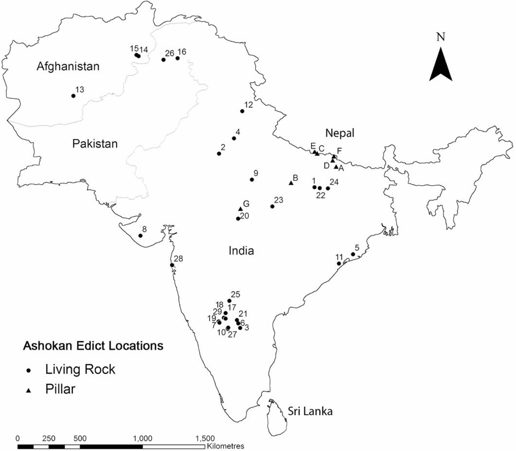
Figure 1. Location of known Ashokan edicts in the Indian subcontinent (numbers denote living-rock edicts; letters denote in situ pillar edicts): 1) Ahraura; 2) Bairat; 3) Brahmagiri; 4) Delhi; 5) Dhauli; 6) Erragudi; 7) Gavimath; 8) Girnar; 9) Gujarra; 10) Jatinga-Ramesvara; 11) Jaugada; 12) Kalsi; 13) Kandahar I & II; 14) Lampaka (Pul-i Darunta); 15) Laghman I & II; 16) Mansehra; 17) Maski; 18) Nittur; 19) Palkigundu; 20) Panguraria; 21) Rajula-Mandagiri; 22) Ratanpurwa; 23) Rupnath; 24) Sahasram; 25) Sannati; 26) Shahbazgarhi; 27) Siddapur; 28) Sopara; 29) Udegolam; A) Araraj; B) Kausambi; C) Lumbini; D) Nandangarh; E) Nigliva; F) Rampurva; G) Sanchi. Note that K.R. Norman (2012: 60) has suggested that Sannati was originally a free-standing slab, but because it was recovered lying within a Brahmanical temple in an obviously displaced condition, it is treated here as a living-rock exemplar.

Figure 2. Sandstone pillar carved with Ashokan edict at the ancient city of Kausambi, India (photograph by Monica L. Smith).
The living-rock inscriptions, in contrast, encompass a distinctly different logic of placement. They are distributed in a much wider geographic range, with 31 such inscriptions currently known throughout the northern subcontinent. They are found as far west as Shahbazgarhi (Afghanistan), through Pakistan, into India eastward along the southern fringe of the Ganges plain and as far south as Jatinga-Rameshwara in the Indian state of Karnataka. There is little apparent consistency in their makeup and positionality: some are carved on sandstone and others on basalt, and some are placed in prominent locations within the heart of ancient settlements, while others are tucked away at the midpoint of rocky outcrops or in otherwise unremarkable locations away from ancient cities (Figure 3).

Figure 3. Living-rock inscription in New Delhi; inset shows devotional items recently deposited by local and international pilgrims (photograph by Monica L. Smith).
Despite their importance for the study of Buddhism and state formation in the subcontinent, much remains to be learned about the Ashokan inscriptions.The known edicts bear the marks of several different styles (Falk Reference Falk2006, Reference Falk2013), but there has been little systematic palaeographic study to discern the number of scribal ‘hands’ involved in their production. In addition, there is considerable variance on what ‘counts’ as an edict. The total number of inscriptions thus varies, with some lists including the Barabar Caves inscription of eastern India and a portable stone (now lost?) from Mahasthangarh in Bangladesh (although Thapar Reference Thapar1997 [1961]: 233 identifies the Mahasthangarh inscription as ‘pre-Ashokan’, an assessment that has interestingly prompted little subsequent commentary). Finally, the number of exemplars remains small, although the widespread distribution of known edicts indicates the likelihood that more of them exist than are currently known. About once every decade, a previously unknown Ashokan living-rock inscription has been discovered, with the most recent in 2009 (Thaplyal Reference Thaplyal2009; Falk Reference Falk2013; Figure 4). In India, newly found inscriptions are greeted with considerable public and media attention and are subsequently protected by the governmental Archaeological Survey of India, which has installed enclosures, translations and tourist facilities.

Figure 4. Discovery date of Ashokan living-rock inscriptions (note that there are three additional inscriptions for which precise first dates of recording are not known: Rajula-Mandagiri in the early 1800s; Rupnath in the 1870s; and Lampaka, in Afghanistan, recognised some time before 1932; data from Falk Reference Falk2006).
The total original number of Ashokan living-rock inscriptions will never be known, but the potential for the discovery of more inscriptions is a realistic proposition. As Romila Thapar (Reference Thapar1997 [1961]: 169) has argued, the text of the fourteenth Major Rock Edict indicates that Ashoka:
had these edicts inscribed throughout the country in complete or abridged versions. It appears from this that the extant inscriptions were not the only ones to be published and that many more versions were either inscribed on rock and remain as yet undiscovered, or else were made public in other forms.
The impetus for the discovery of new Ashokan inscriptions is also made increasingly urgent by the speed of landscape modification throughout South Asia. Quarries are being expanded to supply construction material to growing populations (e.g. Biagi Reference Biagi2006; Selvakumar Reference Selvakumar2010); dams are flooding valley floors in which archaeological remains are located; and agricultural intensification is modifying the landscape around known and potential inscription areas (Paddayya Reference Paddayya1996; Sugandhi Reference Sugandhi2008: 135–36, 163).
To our knowledge, no systematic programme has ever been developed to identify the potential locations of additional inscriptions. The locational characteristics of Ashokan edicts can, however, be used to analyse known living-rock inscriptions and to identify places for efficient ground-based research. For this project, the minimum standard for the identification of an ‘edict’ was the presence of wording that also appears on other inscriptions, indicative of deliberate copying of a standardised text (Figure 1; see Thapar Reference Thapar1997 [1961] for texts and translations). Locations of known Ashokan edicts were mapped against landscape data, both for the study of currently known edicts and to suggest locations for further research.
Predictive modelling for archaeological discovery and the HYDE 3.1 database
Predictive modelling, used across the biological and geographical sciences, is an approach that employs large datasets to identify the probable location of specific types of natural resources and cultural phenomena. Predictive modelling can also serve as a tool of heritage management, so that sites can be located and mitigated prior to construction, or avoided altogether if the planned construction can be relocated. Further, predictive modelling can be undertaken in the recognition that not all archaeological resources are perceived to be of similar ‘value’, resulting in the prioritisation of some types of heritage by national governments and funding agencies. Archaeologists increasingly focus their investigations on the most probable locations of ancient settlements and other sites, particularly when faced with limited accessibility due to factors of ownership, incipient or actual warfare, and other legal and logistical issues (e.g. Ford et al. Reference Ford, Clarke and Raines2009; Watson Reference Watson2011; Huynh et al. Reference Huynh, Ponto, Lin and Alko Kuester2013).
The following assessments make use of the History Database of the Global Environment (HYDE 3.1), a data compilation of population density and land-use capacity for the Holocene (Klein Goldewijk et al. Reference Klein Goldewijk, Beusen and Janssen2010, Reference Klein Goldewijk, Beusen, van Drecht and de Vos2011). The HYDE 3.1 database combines projected population data with land-use data to model long-term global change related to human environmental use at a 5-minute resolution (9.26km pixel size). In the short time since its release, it has been championed as the “first and most popular model” of global land use (Ellis et al. Reference Ellis, Kaplan, Fuller, Vavrus, Goldewijk and Verburg2013: 7979), and has been used to model large-scale scenarios as diverse as ancient Roman water networks (Dermody et al. Reference Dermody, Van Beek, Meeks, Klein Goldewijk, Scheidel, van der Velde, Bierkens, Wassen and Dekker2014) and the effects of pre-modern rice agriculture on methane levels (Fuller et al. Reference Fuller, Van Etten, Manning, Castillo, Kingwell-Banham, Weisskopf, Qin, Sato and Hijmans2011). For this edict-modelling project, we focused on cultivable land, pastures and population configurations starting in the first millennium BC to contextualise the relationship between population and the location of the Ashokan inscriptions, and to identify areas of high population density where inscriptions might be expected but have not yet been identified. Locations of Ashokan inscriptions were overlaid in ArcMap 9.3 (ESRI, Redlands, CA, USA) for three time periods: 1000 BC, AD 0 and AD 200 (the available HYDE datasets that bracket the time period of the Ashokan inscriptions).
Like other datasets compiled from multiple source inputs, the scale and resolution of the HYDE 3.1 database is coarse-grained and may gloss over the subtleties of any particular local landscape (a common critique of broad-scale interpretation: see Edwards Reference Edwards, Misa, Brey and Feenberg2003: 223; Ellis et al. Reference Ellis, Kaplan, Fuller, Vavrus, Goldewijk and Verburg2013: 7983). However, the trade-off to these shortcomings is that the coverage provided by mass datasets is comprehensive and based on standard and repeatable elements of measurement. Environmental data of the type captured in the HYDE 3.1 database is objective and available for entire landscapes, a ubiquity and evenness of coverage that is usually more comprehensive than information about archaeological sites (Kvamme Reference Kvamme1992: 22; Stark & Garraty Reference Stark and Garraty2008). Evaluations of human landscape use indicate that people do selectively target specific areas, and that migrating peoples in particular select the salient characteristics of new landscapes to match memories of familiar places (Rockman & Steele Reference Rockman and Steele2003). In South Asia at the end of the first millennium BC, increased population density, urbanism, agricultural intensification and Buddhism were co-dependent and emerged together (Shaw & Sutcliffe Reference Shaw and Sutcliffe2003: 82; Singh Reference Singh2008: ch. 6), rendering HYDE's land/population mapping particularly suitable for the study of cultural phenomena.
HYDE 3.1 and the locational analysis of the Ashokan edicts
Where are the Ashokan edicts found and not found, compared to the HYDE 3.1 data? As might be expected, more than half of the known inscriptions are located in the areas of highest population density, including the Gangetic plain of the northern subcontinent, which was home to the large territorial dynasties known as the mahajanapadas from the sixth century BC (Figures 5–7). Engravers and sponsors of inscriptions sought to maximise the number of people exposed to the royal message, as seen in the fact that the HYDE map of population centres in AD 200 (more than 400 years after the placement of the edicts) was the probable result of populations that grew in size after Ashokan investment in those areas (cf. Shaw & Sutcliffe Reference Shaw and Sutcliffe2003: 86). Inscriptions are also located along the eastern coast of the subcontinent where Ashoka defeated the Kalinga polity and emplaced a particularly conciliatory set of inscriptions (Figure 1: 5 & 11). The third concentration of edicts is in the south-central peninsula, where scholars have long surmised that the inscriptions reflected the control, or attempted control, of rich mineral resources, including the Kolar gold fields (Thapar Reference Thapar2006: 298). The south-central subcontinent also presented a sophisticated audience for long-distance cultural contact, as suggested by the evidence for early trade and the use of script on portable objects (Rajan Reference Rajan2008), along with high population densities as indicated by large megalithic burial sites (Brubaker Reference Brubaker2008).

Figure 5. HYDE 3.1 data illustrating population density in 1000 BC, with the location of third-century BC living-rock Ashokan inscriptions.
Interestingly, there is at least one inscription in an area that does not appear to have a high spike of population density: Girnar, in the western subcontinent. This Ashokan inscription is made notable, however, by the presence of two later engraved texts in the same location: a lengthy hagiographical inscription by the local ruler Rudradaman in AD 150, identifying the construction of new irrigation canals, and another from c. AD 450 commemorating the construction of an embankment (Keay Reference Keay2000: 130, 144; Lahiri Reference Lahiri2011). Although Ashokan inscriptions are usually assumed to have been engraved during Ashoka's own lifetime, the presence of this exemplar far from obvious concentrations of population invites consideration of alternative explanations, such as the presence of an as yet unidentified resource (analogous to the southern Kolar gold fields), or the possibility that this otherwise anomalous edict could have been carved by a local ruler as a form of competitive emulation (Norman (Reference Norman, Olivelle, Leoshko and Ray2012: 55) notes a number of alternate spellings present in the inscription). Alternatively, the inscription here may have been engraved long after the third century BC as part of the preparation for Rudradaman's proclamation.
The strong correlation of population density with the location of edicts points to six areas for further research. One area is in the farthest southern subcontinent, which was the domain of the Chola, Chera and Pandya dynasties of the late first millennium BC (Abraham Reference Abraham2003). Although investigations in this area should not be discouraged, the documented presence of non-Mauryan polities and the fact that more than a century of concerted archaeological investigation has never encountered Ashokan inscriptions are good predictors that edicts are unlikely to be found in this area. Another area is Sri Lanka, where the lack of edicts similarly indicates that the link between political and ritual investments was not straightforward; the lacuna is particularly interesting given Ashoka's documented ties to Sri Lanka via Buddhist emissaries, the presence of urban centres on the island, and the known use of writing contemporaneous to Ashoka's time (Coningham & Young Reference Coningham and Young2015). Four other areas of HYDE-identified high-density population are more likely to yield as yet undiscovered Ashokan inscriptions (labelled A, B, C & D on Figures 6 & 7). Area A is the headwaters of the Indus River, midway between the Ashokan capital city of Pataliputra and the farthest western exemplars, now in Afghanistan (Kandahar, Laghman and Lampak). Area B is the foothills of the Himalayas in the immediate vicinity of Pataliputra and within the same length of radius as Sahasram, the closest known inscription to Pataliputra. In areas A and B, pillars might have substituted for living-rock inscriptions, particularly given the proximity of the Ashokan capital city and quarries suitable for the extraction of monoliths in area B. Systematic surveys in these regions should target not only living-rock areas close to natural corridors of transport, but should focus also on the potential for the repurposing of monolithic columns—which have variously been found used as road rollers (Falk Reference Falk2006: 148–49) and worshipped as incarnations of deities (Falk Reference Falk2006: 166).

Figure 6. HYDE 3.1 data illustrating population density in AD 0, the location of Ashokan living-rock inscriptions, and the Mauryan capital city of Pataliputra in the Ganges Valley. Locations A, B, C and D, discussed in the text, identify areas of high population density where no Ashokan rock inscriptions have yet been found.

Figure 7. HYDE 3.1 data illustrating population density and Ashokan living-rock inscriptions in AD 200.
Area C is the Narmada River Valley, an area known to have a long human occupational sequence, including the earliest identified hominid in the subcontinent (Sonakia Reference Sonakia1985). The Narmada region subsequently had a high density of archaeological sites indicative of a potential target population for the political and religious authority expressed in the Ashokan inscriptions.
The final region of high population density identified by the HYDE 3.1 data is the Godavari River region of south-central India (point D). As with the Narmada River Valley, this region has a long record of human habitation, including as a settlement corridor for megalith-building populations starting in the early first millennium BC, succeeded by a strong Buddhist investment from the third century BC. The region also has a long tradition of archaeological research and investigation, including at the Buddhist site of Salihundam (Subrahmanyam Reference Subrahmanyam1964), and Thotlakonda and Bavikonda (Fogelin Reference Fogelin2006). The Godavari region is located between two bands of known inscriptions on the eastern coast and in the south-central subcontinent; if sculptors were sent out from the Gangetic heartland towards the south, they would necessarily have passed through either the Narmada River region or the Godavari River region. Further investigations in these areas should also target corridors of trade, given the close physical association of Buddhist monastic sites with economic activity (Ray Reference Ray1986; Liu Reference Liu1988).
Discussion
Population density alone is insufficient to predict the location of cultural phenomena, for which factors of preference, strategy and technological skill were integrated with specific features of local landscapes. In the case of the Ashokan living-rock edicts, for example, the highly selective placement of inscriptions would have been achieved by specific individuals (skilled stonemasons or engravers) who used specific criteria of landscape evaluation for placement (cf. Morrison & Lycett Reference Morrison and Lycett1997: 224). These criteria would have included environmental cues such as the presence of suitable stone and cultural factors including the presence of roads and passages frequented by travellers, in addition to the location of population centres represented by cities, towns and Buddhist establishments.
Engravers would probably have been part of a small group, perhaps similar to the ‘travelling skilled artisans’ that Wayman and Rosen (Reference Wayman and Rosen1990: 52–53) have envisaged for the sculptors who embellished contemporary Buddhist monuments. The presence of a small group whose activities were limited to the Ashokan era (and hence indicative of training in both the textual contents and the execution of rock-cut lettering) is further suggested by the fact that the nature of inscriptions changed after the third century BC. Stone inscriptions continued to be profusely used for individual and collective donations to religious institutions. Royal living-rock texts are rare, however, and appear only in single exemplars (e.g. the Heliodorus pillar from the second century BC in central India (Singh Reference Singh2008: 372) and the Udayagiri living-rock inscription of Kharavela from the first century BC in eastern India (Sahu Reference Sahu1984)), rather than as a series of repeated texts, as was the case with the Ashokan edicts.
Use of the comprehensive HYDE 3.1 dataset provides an important starting point to identify regions to search for additional Ashokan inscriptions. A systematic programme of research in targeted areas for discovery can make use of longstanding collaborations with local inhabitants, given that the South Asian archaeological and historical records are replete with examples in which previously unknown sites, manuscripts and artefacts have been discovered through the participation of non-academics. New technologies for recording and sharing data now provide the opportunity to increase the level of public participation in research through mobile technology and easy-to-use GIS applications that enable researchers to create massive datasets that lend robusticity to predictive models (Smith Reference Smith2014). Such ‘citizen-science’ interfaces already exist in the subcontinent in disciplines such as botany and biology (e.g. India's Common Bird project (Common Bird Monitoring of India n.d.)). In the case of stone inscriptions, images tagged with geo-locations—taken, for example, with mobile telephones—could allow researchers to systematically access ‘citizen’ sightings that could then be confirmed through follow-up visits by archaeologists and epigraphers; over time, the corpus of images could also provide a means of monitoring condition and preservation. The resurgence of interest in the Indian subcontinent as the homeland of Buddhism has greatly increased local and external participation in heritage discovery, providing confidence that any newly found edicts will be a focus of protection (see Figure 3: inset). Public recognition of such inscriptions is also key to their preservation; for example, the Bahapur inscription in the suburbs of Delhi was recognised by a contractor “as it was about to be blasted away for the development of a residential colony” (Joshi & Pande Reference Joshi and Pande1967: 96). Inscriptions themselves tend to become sacred in the landscape and, as such, well known to local inhabitants who could be encouraged to share their findings (cf. Suvrathan Reference Suvrathan2013).
Models can provide not only new ways of looking but also new ways of thinking, even for areas that are inaccessible to fieldwork, as described for Syria (Menze & Ur Reference Menze and Ur2012) and Mongolia (Huynh et al. Reference Huynh, Ponto, Lin and Alko Kuester2013). The use of a comprehensive database such as HYDE 3.1 in the Indian subcontinent for both locational analysis and predictive modelling thus provides the opportunity to evaluate regional patterns where international collaborative research is hampered by logistical or political constraints. When ground-based survey is carried out by local teams, researchers can collectively benefit from distributed networks of investigation to recover data for continental-scale investigations. Archaeological fieldwork in the subcontinent demonstrates the existence of many as yet unrecorded inscriptions (e.g. Jayaswal Reference Jayaswal1998; Suvrathan Reference Suvrathan2013; Kalra forthcoming), such that a targeted search for Ashokan edicts could potentially yield a collateral harvest of other texts as well. Results can be fed into future iterations of HYDE-like models, fulfilling the call for “more comprehensive, spatially detailed, quantitative and accurate” data that can be used to address questions of regional and global land-use history (Ellis et al. Reference Ellis, Kaplan, Fuller, Vavrus, Goldewijk and Verburg2013: 7983).
Conclusion
The Ashokan inscriptions of South Asia constitute one of the most galvanising examples of writing as a transformative ancient political technology. The inscriptions are also significant for the study of Buddhism, which is today a global religious tradition but was a small and relatively unknown sect prior to the royal support that it received from Ashoka. The HYDE 3.1-derived map of Ashokan edicts identifies several areas for systematic research: the upper Indus Valley; the Himalayan foothills adjacent to the Ashokan capital city; the Narmada River Valley; and the Godavari River Valley. In all of the South Asian countries in which edicts are known, there are still many areas in which little or no systematic archaeological fieldwork has ever been conducted, despite the presence of strong governmental agencies and many college and university departments of archaeology. The addition of newly discovered exemplars through targeted surveys and citizen science interaction would provide not only an increased tally of these significant texts but would also enable us to evaluate the nature of the political ties among regions in the time of the Indian subcontinent's first ‘empire’ in the third century BC.
Acknowledgements
We would like to thank Rabindra Kumar Mohanty and Namita Sugandhi for conversations about the Ashokan inscriptions, Matt Zebrowski for comments on the figures, and Randall Law for helpful references to geological maps. We also greatly appreciate the insightful comments from Robin Coningham, Julia Shaw and the anonymous reviewers. Support was provided by the UCLA Office of the Vice Chancellor for Research in the form of a Transdisciplinary Seed Grant to Smith and Gillespie. The location map on the title page of the article was provided by Antiquity.


