


Pre-Columbian transoceanic contacts have long been controversial. The controversy stems from the fact that those supporting arguments for such crossings have often not evaluated the evidence as critically as was necessary. On the other hand, those dismissing these arguments have frequently ignored the inevitability of such events over long periods of time. One aspect of these debates that is seldom evaluated is the likelihood of vessels, with or without survivors, or floating artefacts, crossing oceans. As an example, a recent debate (Hristov & Genovés Reference Hristov and Genovés1999, Reference Hristov and Genovés2011; Shaaf & Wagner Reference Shaaf and Wagner1999; Smith Reference Smith2011) centred on the head of a Roman figurine purportedly discovered in a pre-Columbian context at the site of Tecaxic-Calixtlahuaca in Mexico. Neither argument for or against the veracity of the pre-Columbian context of the artefact discusses how likely drift events are across the mid-Atlantic.
Despite resistance to the idea of pre-Columbian crossings of the mid-Atlantic in history and archaeology, such crossings are likely. Crossings need not have been intentional, and numerous examples to support this theory exist from recent times. Many of these crossings are due to shipwreck and were accomplished with small, open vessels. In some cases the occupants survived the voyage, in others they did not. Survival of the occupants was not necessary for Old World artefacts to be found in New World pre-Columbian contexts.
One of the oldest watercraft in the world was recovered in Africa; the Dufuna canoe (Breunig et al. Reference Breunig, Neumann and van Neer1996: 116–17) was discovered south-west of Lake Mega-Chad near the Komagudu Gana River. The canoe dates to about 8000 years ago. Breunig et al. state that at that time the Komagudu Gana was in some way connected to Mega-Chad, which was then comparable to the Caspian Sea. The canoe is made of a water-resistant mahogany, and it measures 8.4m in length and 0.5m in width. Similar canoes are still used along the West African coast and inland. Although larger, Mediterranean vessels may also have drifted across the mid-Atlantic at later times; the time-depth for vessels similar to the Dufuna canoe makes something like it the most probable, but not exclusive, candidate for a crossing anytime over the last 8000 years.
Lengthy drift voyages in open boats due to shipwreck or other misfortune are well known from the tropical Pacific (Howay Reference Howay1944; Levison et al. Reference Levison, Ward and Webb1973: 20–21) under conditions similar to the mid-Atlantic. The maximum recorded drift with survivors in this region seems to be seven or eight months, although a few recent, but unanalysed, cases may be as long as eleven to thirteen months. There are several recorded voyages that covered distances of c. 5500km over a period of six to ten weeks, and a great number covering shorter distances. On most but not all of these voyages at least some water was collected from precipitation, but there are other sources such as collecting dew (Bombard Reference Bombard1986: 61), pressing fluid out of fish and even utilising the fresh water in the tube of toredo worms (Lee & Lee Reference Lee and Lee1980: 139–60).
Dening (Reference Dening and Golson1963: 138–53) cites the limited empirical evidence for known drift voyages in Polynesia, and suggests a common pattern of behaviour in which sailors conclude that they are lost early in the voyage and respond by allowing the vessel to drift before the wind, with no attempt to navigate in a particular direction. This strategy allows close to the maximum distance to be covered in a given time when there is no clear indication of relative location.
Although open boat and larger vessel drift voyages across the mid-Atlantic have not received the same degree of attention as those of the Pacific, they have occurred. Probably the best known in recent times is that of Alain Bombard (Reference Bombard1986 [1952]). Bombard crossed the Atlantic from the Canary Islands to Barbados in a 4.5m Zodiac boat with minimal provisions. His claim to have successfully relied on drinking seawater was later questioned by Hannes Lindemann (Reference Lindemann1958) who himself crossed the Atlantic twice; the first time in a 7.5m dugout canoe from the Canary Islands to Jacmel, Haiti. The second voyage was done in a small sea kayak from the Canary Islands to the Antillean island of St Martin, taking 76 days. Lindemann carried more provisions than Bombard, but they would still be considered minimal.
These examples are of intentional voyages, but there have also been unintentional drift voyages in recent times. In 1981 Steven Callahan spent 76 days lost at sea (Callahan Reference Callahan1986). Seven days out of the Canary Islands he was shipwrecked and drifted in a life raft to the waters of Guadeloupe, where local fishermen rescued him. Another example of drift from the Canaries to the Americas, although with a less happy outcome, happened in 2006 (Tremlett Reference Tremlett2006). A 6m yacht, in poor condition, was found 70 miles off Barbados. The 11 occupants were dead and it was suspected that an additional 40–50 individuals had been on board. The vessel was heading from the Cape Verde Islands to the Canary Islands with Senegalese immigrants. The vessel had been at sea for about four months.
What these examples demonstrate is that even small vessels, with or without survivors, can drift across the mid-Atlantic at least as far as the Antilles. Even the intentional voyages cited here were, for experimental reasons, very sparsely provisioned.
Computer simulations of maritime contact
Computer simulations have been used to elucidate several archaeological and historical problems dealing with issues of maritime colonisation, cultural contact and interaction. The approach has been used worldwide, including: the Pacific Islands (Avis et al. Reference Avis, Montenegro and Weaver2007); the Caribbean (Callaghan Reference Callaghan2003a); between Ecuador and Mexico (Callaghan Reference Callaghan2003b); Costa Rica and Colombia (Callaghan & Bray Reference Callaghan and Bray2007); from Japan to North America (Callaghan Reference Callaghan2003c); and other regions (Montenegro et al. Reference Montenegro, Hetherington, Eby and Weaver2006).
The simulation uses the wind and current data from the digital US Navy (1995) Marine climactic atlas v.1.1. Wind and current data that are frequency weighted according to the compiled observations are randomly selected. These forces are then allowed to operate on vessels for a 24-hour period before a new selection is made (see Levison et al. Reference Levison, Ward and Webb1973). How these forces affect specific vessel types varies by shape. Here, the generalised performance characteristics of a variety of small open boats (Levison et al. Reference Levison, Ward and Webb1973) are used. Some of these vessels are very similar to the Dufuna canoe in size and shape. Vessels or other objects floating higher or lower would make faster or slower transits of the Atlantic respectively due to wind effects. If larger vessels with their sailing capability intact are considered, crossings would be even faster as they only involve downwind sailing with no sailing to windward required.
For this study 100 simulations were run from just west of the Canary Islands for each month of the year, starting at the beginning of the month. When the duration reached the end of a month, the data for the subsequent month was used. Vessels were allowed to drift before the winds and currents with no attempt to affect their course. This is a strategy that maximises the distance covered when sailors are lost at sea with no reference points. The maximum number of days for survivors was set to 200, which is the maximum for open boat drifts.
Results
The results of the simulation are given in Table 1. The table shows the percentage of drifts reaching the Americas, the mean duration in days and the range of drift durations. For drift voyages beginning in January all vessels reached the Americas within the 200-day maximum limit, with a range of 70–187 days and a mean of 96 days. Ten vessels reached Central America. The majority made landfall in the Antilles. The remainder landed in South America between the Gulf of Darien and Fortelaza, Brazil. February drifts were pushed south, although all made landfall within 200 days. Eighty-nine per cent landed in the Americas and 11% returned to the Canary Islands. The range of American drifts was 65–150 days with a mean of 77 days. Two vessels landed in Panama and Costa Rica, sixteen landed in the Antilles. The remainder landed in South America as far south as Rio de Janeiro. Wind and current systems pushed vessels farther southward in March, with 84% landing in the Americas and 16% in the Canaries. American landfall durations ranged from 63–122 days; the mean was 80 days. Only one landed in Central America and ten in the Antilles. The rest landed in South America as far south as Santos, Brazil. All drifts were within 200 days. This pattern continues in April. The mean duration was 75 days for American landings; the range was 64–136 days. Twenty per cent of drifts returned to the Canary Islands, the remainder landed in the Americas with three vessels landing in Costa Rica and Panama. Only six vessels landed in the Antilles, the rest landed in South America. No voyages exceeded 200 days.
Table 1. Drift durations and percentage success from the Canary Islands to the Americas.

Wind and current patterns shift northward in May, with most vessels landing in north-east Brazil. One vessel reached Panama and seven reached the Antilles north of Trinidad. Many vessels landed on Trinidad. The average duration of voyages landing in the Americas was 74 days and the range was 62–166 days. One vessel landed in Africa. Eighty-six per cent of vessels reached the Americas, with 14% returning to the Canary Islands. No vessels exceeded 200 days. With drifts beginning in June 93% reached the Americas. The northward shift in landfalls continued in June as about 45% of vessels landed in the Antilles; one made landfall in Panama. The majority of the remaining vessels landed in north-east Brazil and the Guayanas. The mean duration for American landings was 80 days with a range of 67–146 days. Seven drifts returned to the Canaries and none exceeded 200 days. Patterns shift in July; 13 vessels landed in Africa while 22 exceeded 200 days. Fourteen vessels landed in the Canary Islands. Fifty-one per cent of vessels reached the Americas. Six vessels landed in Central America between Belize and Panama, and six landed in the Antilles north of Trinidad. Aside from a few remaining vessels landing in South America, the rest made landfall at Trinidad. Durations of drifts to the Americas ranged from 69–185 days; the mean was 110 days. This July pattern is accentuated in August when only 26 vessels made landfall in the Americas, 21 vessels landed in the Antilles, 3 landed in South America and 2 in Central America. The mean duration of the drifts to the Americas was 83 days with a range of 69–144 days. Twelve vessels exceeded the maximum limit and five returned to the Canary Islands. The rest made landfall in Africa.
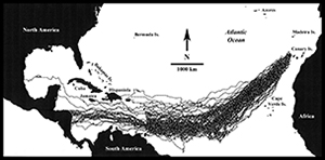
Conditions again shift in September (Figure 1), with all except six vessels landing in the Americas within 200 days and one returning to the Canary Islands. Three vessels landed in South America, while twenty vessels landed in Central America and one landed on the central Mexican coast. The remaining vessels landed in the Antilles. The average duration of the drifts to the Americas was 111 days with a range of 74–170 days. In October (Figure 2) 94% of drifts landed in the Americas. Three vessels landed in South America and ten vessels landed between Belize and Costa Rica. One vessel landed on the east coast of the United States. The remainder of the drifts to the Americas landed in the Antilles. The mean duration of American drifts was 106 days with a range of 77–170 days. Two vessels landed in the Cape Verde Islands and one in the Canary Islands. Three vessels exceeded 200 days. Voyages beginning in November (Figure 3) all landed in the Americas except for one that landed in the Cape Verde Islands and three that returned to the Canaries. Seventeen vessels landed in Central America between Honduras and Panama and eight in South America; the remaining vessels landed in the Antilles. The mean for American drifts was 110 days with a range of 80–151. For December five vessels exceeded 200 days, two landed in the Azores and three in the Canaries. Seven landed in South America and eight in Central America between Panama and Honduras. The remaining vessels landed in the Antilles. Durations of the American drifts ranged from 77–169, with a mean of 105 days.

Figure 1. Map showing drift predictions for voyages begun in September.

Figure 2. Map showing drift predictions for voyages begun in October.

Figure 3. Map showing drift predictions for voyages begun in November.
Overall, about 82% of vessels made landfall in the Americas, with most landing in the Antilles or Brazil, yet in some months as many as 21% of vessels landed on the Central American or Mexican coasts. Most of the vessels not crossing the Atlantic either returned to the Canary Islands or, especially in July and August, landed in West Africa. Very few vessels exceeded the 200-day survival limit.
Discussion
From the simulations it is clear that for most of the year vessels disabled or lost at sea off north-west Africa would probably make landfall in the Americas. This is particularly true between September and June. The majority of vessels would make landfall in the Antilles from September to January. The Antilles themselves act as a screen preventing large numbers of vessels from making landfall on the Central or North American mainland; some do, however, make landfall on the mainland, especially in lower Central America. For landfalls in the Antilles the average duration of voyages is about 70 days, and for Central America and Mexico the average is about 120 days. This is well within the 200-day limit for open boat survival recorded for the Pacific and for the Antilles within recent drifts and survival experiments. Yet as noted above, survivors are not necessary for Old World artefacts to be found in New World pre-Columbian contexts.
A point to consider given the high number of landfalls in the Antilles is the date of human occupation there. The Windward Islands in the southern range of the Lesser Antilles do not appear to have been occupied until the first centuries AD (Callaghan Reference Callaghan, Fitzpatrick and Ross2010; Fitzpatrick & Giovas Reference Fitzpatrick and Giovas2011). Some, but not all, of the Leeward Islands to the north, Antigua in particular, were occupied, perhaps as early as the third millennium BC (Fitzpatrick Reference Fitzpatrick2006: 397). Some, however, were not occupied until sometime after 500 BC (Wilson Reference Wilson2007: 45). The Greater Antilles were occupied even earlier than Antigua, perhaps even before 4000 BC (Reid Reference Reid, Reid and Grant Gilmore III2014: 54), although Jamaica is anomalous in this respect as it does not appear to have been occupied until about AD 600 (Callaghan Reference Callaghan2008). If ships were not severely disabled during the voyage, survivors may have opted to continue westward with the winds and currents rather than stay on small, unoccupied islands. If voyagers were in a position to raise a sail and attempt to proceed due west before reaching the Lesser Antilles, they would probably reach land farther north in the Bahamas, as did Columbus on his first voyage (Fuson Reference Fuson1987). This could be a strategy used by sailors after initially becoming lost, as for most of the year would it would have been difficult to sail eastward given the limited ability of earlier Mediterranean vessels to sail to windward (Casson Reference Casson1971). Further, as the Bahamas were occupied relatively late, between AD 600 and AD 700 (Wilson Reference Wilson2007: 106), seafarers from the east may have been induced to continue westward.
Although this analysis has focused on vessels drifting across the mid-Atlantic, there are data for small objects. Kistler et al. (Reference Kistler, Montenegro, Smith, Giord, Green, Newsom and Shapiro2014) have published drift patterns for bottle gourds from the southern tip of Africa to Portugal. The vast majority of gourds make landfall in the New World. It seems inevitable that some materials, either vessels or floating artefacts should end up drifting over the mid-Atlantic to the New World. This should not be surprising given the very large amount of material that floated across the north Pacific to North America after the Japanese tsunami of 2011. All of the oceans have gyres similar to those of the north Pacific and mid-Atlantic, and similar events probably happened elsewhere.
The issue of pre-Columbian transoceanic crossings of the mid-Atlantic (and other transoceanic crossings) should be viewed with a healthy scepticism, but they should also be evaluated on the likelihood of such events occurring. It is not difficult to gain some sense of these by using similar simulations to those that are used here. It is also possible to evaluate the chance of there being human survivors. In the case of a mid-Atlantic crossing it is almost inevitable given the evidence for watercraft 8000 years ago. This is a long time for even rare events to add up to a significant number.
Acknowledgements
I would like to thank Dr Romeo Hristov for first getting me interested in problems of materials crossing the mid-Atlantic. I would also like to thank the Kon Tiki Museum for a grant that partially funded this work.


