


Introduction
The generation of complex ideological systems was key for ancient state building, expansion and maintenance (Goldstone & Haldon Reference Goldstone, Haldon, Morris and Scheidel2009). While ideas and beliefs legitimise authority, power and social differences, they also require the materialisation of beliefs. During the Middle Horizon (AD 600–1000), the Wari polity expanded out of the Ayacucho Valley in Peru and connected several Peruvian highland, lowland and coastal areas through the interregional exchange of materials and ideas. Evidence of this political expansion is based on the presence of recognisable artefact styles and architecture (Menzel Reference Menzel1968; Lumbreras Reference Lumbreras1974). The distance between the polity's northern and southern frontiers was approximately 1300km (Schreiber Reference Schreiber1992; Williams & Nash Reference Williams and Nash2006). The largest Wari site, Huari, located in the Ayacucho Valley at about 2800m asl, is considered to have been the capital city of this expansive polity. But how did the Wari heartland maintain authority and social differentiation over such a vast region?
Huari was a large (approximately 1.5km2) urban centre featuring high walls, monumental funerary complexes and D-shaped plazas (Benavidez Reference Benavidez, Isbell and McEwan1991; Isbell Reference Isbell, Isbell and McEwan1991; Ochatoma & Cabrera Reference Ochatoma and Cabrera2000; Cook Reference Cook, Benson and Cook2001). At least part of the city included rectangular compounds with central patios, which are characteristic of Wari sites. Conchopata—a secondary city of Huari and built approximately 10km distant—was smaller (covering around 20ha), but featured similar architecture (Isbell Reference Isbell2004: 6). The public and private feasts that took place in Conchopata included offerings of oversized ceramics and domestic animals (Cook & Glowacki Reference Cook, Glowacki and Bray2003; Rosenfeld Reference Rosenfeld2011, Reference Rosenfeld2012).
Archaeological and bioarchaeological research suggests that Conchopata housed an intermediate elite that engaged in ancestor-veneration practices as in Huari, but without the large stone tombs characteristic of the capital city (Tung & Cook Reference Tung, Cook, Elson and Covey2006). Tung (Reference Tung2012) has argued that military and ritual activities helped expand and connect the Wari state. There is still debate, however, about the extent of integration within the polity. While research has focused on the degree of control exerted by the heartland over the rest of its territory (Schreiber Reference Schreiber1992; Topic & Topic Reference Topic, Topic, Kaulicke and Isbell2000; Jennings et al. Reference Jennings, Tung, Yepez, Quequezana and Lopez2015a & Reference Jennings, Velarde, Mora and Alvarezb), here we discuss how the centre of the Wari state maintained social differentiation, and how it engaged in long-distance interactions on a vast, regional scale. Characterisation studies and contextual analyses of non-local material can help assess the role of exotic goods in the legitimisation of ruling groups in ancient states or expansive polities. In this article, we use X-ray diffraction analysis to evaluate the origins of a stone artefact, and geographic information systems (GIS) to infer the distances that different materials and artefacts travelled from their source areas to the Wari heartland.
Prestige goods and expansive states
A key factor in the growth and maintenance of states is the formation of distinct social classes that have differential access to wealth and luxury goods (Johnson & Earle Reference Johnson and Earle2000). D'Altroy and Earle (Reference D'Altroy and Earle1985) argued that the development of a political economy to finance governing institutions is key for the emergence of expansive states. One such system is wealth finance: the procurement and manufacture of special objects (Earle Reference Earle1997). The extraction of prestige items can be used to support and legitimise social stratification in a ranked or early state society.
Although societies have circulated metals, textiles, turquoise and marine shells across the Andes for millennia (Contreras Reference Contreras2011; Carter & Helmer Reference Carter and Helmer2015; Sayre et al. Reference Sayre, Miller and Rosenfeld2016; Santoro et al. Reference Santoro2019), scholars have argued that such exchanges increased during the Middle Horizon (AD 600–1000) (Isbell Reference Isbell, Haas, Pozorski and Pozorski1987; Jennings & Craig Reference Jennings and Craig2001). During the Early Intermediate Period (c. 200 BC–AD 600)—before the Wari rose to power—Ayacucho society exhibited very little social differentiation (Isbell Reference Isbell, Haas, Pozorski and Pozorski1987; Leoni Reference Leoni, Isbell and Silverman2006). Excavations at the Ayacucho site of Nawinpukyo (AD 0–600), for example, indicate only limited internal ranking, as interpreted by slight differences among the architectural layout and construction of residential areas, but not in terms of associated artefacts (Leoni Reference Leoni, Isbell and Silverman2006). Foreign items are rare and do not appear to differentiate social groups or residential areas.
Many scholars have stated that the Wari strategy in the polity's periphery was to extract prestige goods, and that the Wari built regional administrative centres to control and distribute local resources (e.g. Isbell Reference Isbell, Haas, Pozorski and Pozorski1987; Schreiber Reference Schreiber, Mackey, Haas, Pozorski and Pozorski1987; Jennings & Craig Reference Jennings and Craig2001: 482; Williams Reference Williams, Chalcatana, Arkush and Marcone2017). Others have argued that there was less direct state control on the periphery, and that many of the Wari sites outside of the Ayacucho Valley were built and maintained by local elites who emulated Wari styles (Jennings Reference Jennings2006). However these prestige goods were obtained, we argue that the procurement of sumptuary or exotic objects and materials was vital to the Wari heartland. Here, we examine the non-local items found in the Wari heartland to locate their provenience and to understand better their circulation, concentration and, perhaps, their political symbolism. While it is possible that the circulation of goods in the hinterland was not directly managed by the state, but rather acquired through trade or non-directed forms of exchange, we argue that the polity's heartland needed these prestige items to build and maintain its own elite population. We discuss the different exotic materials recovered from the Wari heartland to understand the importance that diverse ecological zones played in the development of Huari and its secondary city, Conchopata. We define the presence of material sourced from beyond the Ayacucho Valley—the core of the Wari sphere—as evidence of non-local interaction (Figure 1). The exotic materials discussed in this analysis include animals, metals, minerals and plants, and are summarised in Table 1. We include all previously published data labelled as non-local material (both finished objects and raw material) excavated from the sites of Conchopata and Huari. Gold is not included in this study as, in Peru, this metal is found all along the Andean Cordillera (Petersen Reference Petersen2010: 23), and it is therefore difficult to pinpoint specific sources.
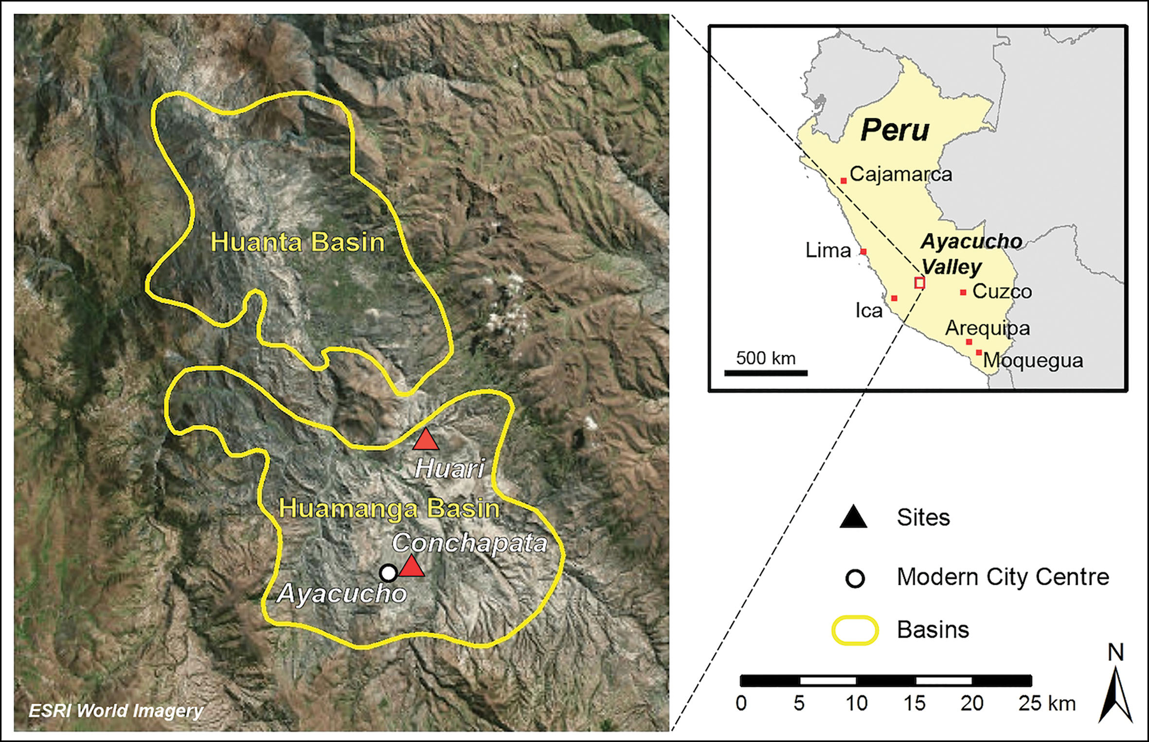
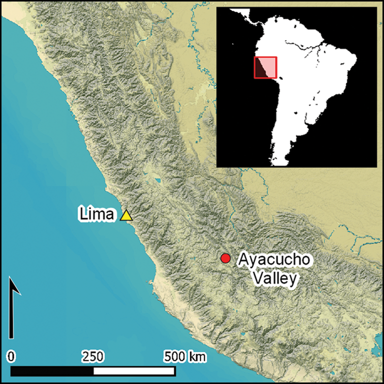
Figure 1. Ayacucho Valley boundaries and the location of the main sites discussed in the text (figure by M. Street & B. Jordan).
Table 1. Select exotic materials recovered from Huari and Conchopata.

Networks of interaction
While the Spanish conquistadors divided the Central Andes from west to east into three broad categories of coast, mountains and jungle, most archaeologists follow Pulgar Vidal's (Reference Pulgar Vidal1981) division into eight ecosystems (‘life zones’), which incorporates Indigenous knowledge of landforms, animal and plant life, and human activities. Here, we mention each ecosystem, along with the materials recovered in Ayacucho that originated from each area (Figure 2).

Figure 2. Non-local materials recovered from Huari and Conchopata and their sources (figure by B. Jordan).
The rich marine life of the Pacific Ocean has long facilitated habitation of the coast and nearby valleys. In the Wari heartland, the ocean is represented by the importation of many marine animal parts. Spondylus (spiny oyster) shells, for example, have been excavated at Huari and Conchopata. In the latter, many Spondylus shells have been recovered from human burials and offering contexts, along with articulated camelid and guinea pig bones (Tung & Cook Reference Tung, Cook, Elson and Covey2006; Rosenfeld Reference Rosenfeld2012). At Huari, Spondylus and Pinctada (mother of pearl) ornaments have been excavated from Cheqo Wasi, a sector of the city featuring megalithic chambers containing more than 100 human skeletons (Benavidez Reference Benavidez, Isbell and McEwan1991: 56). These molluscs originate off the coasts of northern Peru and Ecuador. Other molluscs recovered at Huari include Choromytilus chorus mussels from the south Peruvian coast and coastal Chile, Donax obesulus clams from the coasts of Ecuador to Chile, and Bursa ventricosa snail shell from Pisco on the south coast of Peru (Pozzi-Escot Reference Pozzi-Escot, Isbell and McEwan1991). A few shark teeth have also been recovered at Huari (Ochatoma et al. Reference Ochatoma, Cabrera and Mancilla2015).
The dry coast (Chala, up to 500m asl) by the Pacific Ocean is cut by numerous rivers that flow from the Andes, forming oasis-like valleys. Several ceramic styles at Conchopata and Huari exhibit influence from the central and south coast of Peru (Menzel Reference Menzel1968). Although instrumental neutron activation analysis has demonstrated that the Chakipampa-style ceramics from Conchopata were all manufactured using local clay (Nishizawa Reference Nishizawa2011), their designs exhibit evidence of Nazca influence from the south coast (Menzel Reference Menzel1968). Nishizawa (Reference Nishizawa2011: 185) also suggests that black-slip backgrounds and rim decorations on the Ayacucho society's black-decorated cups were influenced by the Loro style—the local Middle Horizon style of the southern Nazca region. Benavidez (Reference Benavidez, Isbell and McEwan1991: 67) also identified Nazca influence in the ceramics recovered from Huari, along with Nieveria-influenced designs from the central coast.
The foothills (Yunga, 500–2300m asl) to the west and the warm valleys to the east (Rupa Rupa, 400–1000m asl) of the Andes are where the greatest variety of plant and tree species grow. A burnt, pointed lance made of chonta wood (Bactris gasipaes) was recovered at Huari from inside a D-shaped structure (Ochatoma et al. Reference Ochatoma, Cabrera and Mancilla2015: 74). Chonta palm trees are adapted to tropical climates without excessive rain, growing well up to 1200m asl in the Eastern Andes (Bernal Reference Bernal1975). Charred coca seeds have been identified by Sayre and Whitehead (Reference Sayre, Whitehead, Bruno and Sayre2017) at Conchopata. Coca plants are found in the lowlands, growing optimally between 1200 and 1900m asl (D'Altroy Reference D'Altroy2015: 244). Since at least the fifteenth century, coca leaves have been an important component in Andean rituals (Allen Reference Allen1988; Cobo Reference Cobo1996 [1653]). Benavidez (Reference Benavidez, Isbell and McEwan1991: 55) argued that Pati trees (Carica augusti) found at Huari were introduced from lower elevations, as they proliferate in the dry eastern valleys at 2000–2500m asl. The use of Pati cotton-like fruit as stuffing for pillows and mattresses has been documented ethnographically (Galarza Reference Galarza2015). Notably, the Quechua word mallki means both ‘ancestor’ and ‘cultivated tree’. Sherbondy (Reference Sherbondy1986) argues that during Inka times (AD 1450–1535), cultivated trees (as opposed to wild trees) represented the ancestors. It is a possibility that the imported Pati trees in Huari had both symbolic and economic value.
The highland environments include the Quechua zone (2300–3500m asl), where many archaeological sites are located, the Suni zone (3500–4000m asl), where potatoes and quinoa are cultivated, and the Puna zone (4000–4800m asl), where camelid herds are pastured. Most of the metals and lithics recovered from archaeological sites in Peru were quarried from these highlands. Neutron activation analysis conducted by Burger and colleagues (Reference Burger, Bencic and Glascock2016a) demonstrates that most of the obsidian tools and flakes recovered from Conchopata originated from the quarries in Quispisisa located at 4000m asl. While obsidian was abundant across Conchopata, spatial analysis revealed that obsidian artefacts were present in all types of ritual contexts at the site (Bencic Reference Bencic2016: 169).
Small blue flakes have been excavated at Huari and Conchopata, but a deep blue, polished rod (approximately 100mm × 50mm) recovered from Conchopata stands out due to its size, colouring and polishing (Groleau Reference Groleau2009). This blue artefact formed part of an offering placed in a house floor-level pit, alongside ceramic moulds, ceramic pallets and a doughnut-shaped stone (Figure 3). As initial visual inspection suggested that the rod was made of lapis lazuli (the closest source being located in Chile), we analysed its chemical composition. X-ray diffraction (XRD) analysis, however, demonstrates that the blue object is composed of a mix of quartz, the blue mineral dumortierite, a mineral in the illite/mica family and very small quantities of gypsum and kaolinite (Figure 4; see the online supplementary material (OSM)). The closest known potential sources of dumortierite to the Ayacucho Valley are in Cucucha (Lima) and in Cerro Verde (Arequipa) (Figure 2; Petersen Reference Petersen2010: 5).

Figure 3. The blue dumortierite artefact from Conchopata (photograph by W. Isbell).

Figure 4. A portion of the X-ray diffraction scan of the Conchopata blue stone, highlighting intensity peaks corresponding to identified minerals, including the blue mineral dumortierite (figure by B. Jordan).
Cinnabar (mercury sulphide) has been identified in burials at both Huari and Conchopata (Benavidez Reference Benavidez, Isbell and McEwan1991; Tung & Cook Reference Tung, Cook, Elson and Covey2006). The cinnabar was found on human bones, and was used as possible paint or decoration. Burger and colleagues (Reference Burger, Lane and Cook2016b) have shown that the largest cinnabar source in the region is in the Huancavelica area (Figure 2). Isotopic analyses of cinnabar from some pre-Wari and post-Wari contexts in northern Peru demonstrate that the material was brought from Huancavelica (Burger et al. Reference Burger, Lane and Cook2016b). Future geochemical analysis should confirm whether the cinnabar recovered in the Ayacucho Valley was also sourced from Huancavelica. Aside from Huancavelica, Petersen (Reference Petersen2010: 4) identifies possible sources of cinnabar in Ancash and Puno in Peru, all of which are distant from Ayacucho.
Many copper artefacts have been recovered from Huari and Conchopata, predominantly from funerary contexts (Benavidez Reference Benavidez, Isbell and McEwan1991; Tung & Cook Reference Tung, Cook, Elson and Covey2006). Based on lead isotope analysis, Macfarlane and Lechtman (Reference Macfarlane and Lechtman2014) argue that the arsenic bronze artefacts from Conchopata exhibit isotopic ratios compatible with the copper sulfarsenide deposit in the Julcani mine in Huancavelica. Chrysocolla is a blue-green copper silicate that is often mistaken for turquoise (Petersen Reference Petersen2010). Artefacts—predominantly beads—made from chrysocolla have been recovered at both Conchopata and Huari (Benavidez Reference Benavidez, Isbell and McEwan1991; Tung & Cook Reference Tung, Cook, Elson and Covey2006), in association with human burials. Chrysocolla is found as small exposures in Lima, Ica and Arequipa (Petersen Reference Petersen2010: 4).
The Wari heartland's interest in other regions is also demonstrated by the presence of non-local human remains. Tung and Knudson (Reference Tung and Knudson2011) used strontium isotope analysis to demonstrate that most of the trophy heads found in Conchopata were from individuals who spent much of their lives outside the Ayacucho Valley, and probably originated from different geological localities.
In summary, the cities of Huari and Conchopata have yielded abundant evidence of foreign material from many ecological zones (Figure 2 & Table 1). Marine shells, molluscs and shark teeth were brought from the Pacific Ocean and its coast. Chonta wood, coca plants and Pati trees were imported from the lowlands, and a variety of minerals and metals were sourced from other parts of the highlands outside the Ayacucho Valley, including bronze, dumortierite and obsidian. Furthermore, recent instrumental neutron activation analysis data from ceramic-paste groups indicate that Huari imported some ceramics from Cajamarca (1300km to the north), Cuzco (500km to the east) and Moquegua (1000km to the south) (Williams et al. Reference Williams, Nash, Cook, Isbell, Speakman, Glascok, Neff and Vaughn2019).
GIS analysis of transport of foreign material
Ethnohistorical sources indicate that the Inkas used human labour, as well as cargo llamas, to move raw material and objects across their empire (Murra Reference Murra1980). Reconstruction of the actual caravan routes, however, is difficult to document archaeologically (Tripcevich & Capriles Reference Tripcevich and Capriles2016). Through the use of GIS, we synthesise the available Wari data on non-local raw materials and artefacts recovered in Ayacucho to infer distances between the sources and the heartland sites in which they were found. All GIS work was undertaken using ArcMap 10.5 and 10.7. To determine distances and travel times from material sources to the Wari heartland (Huari), least-cost path analysis was performed following the method described by Tripcevich (Reference Tripcevich2009), and updated to utilise the ‘cost path as polyline’ tool, which first became available in ArcMap 10.6. This method incorporates Tobler's (Reference Tobler1993) hiking function, which minimises travel time and energy. This function is given as W=6 e-3.5 abs (tanθ + 0.05), where W is walking speed in km/h and θ is slope angle. Transport of cargoes to Huari could have made use of llamas, porters or a combination of the two. In either case, Tobler's hiking function—designed for human travel on foot—is appropriate, as llamas cannot carry humans and would have been accompanied by walkers (for a similar approach in the Andes, see Contreras Reference Contreras2011; Covey et al. Reference Covey, Bauer, Belisle and Tsesmeli2013).
The first step in the least-cost path analysis was to derive two rasters from a digital elevation model. The first is a path-distance raster that contains the calculated travel times from all cells to the source (Huari), and the second is a back-link raster that identifies, for each cell, the neighbouring cell that is on the least-accumulative cost path to the source. Least-cost paths were determined from these rasters using the Cost Path as Polyline tool. The input digital elevation model used the NASA Shuttle Radar Topography Mission Global version 3 (SRTM_GL3) coverage, with a 90m resolution, supplied by the OpenTopography facility (opentopography.org). The emphasis on topography is justified because the altitudinal diversity of the Andes region means that this is the most significant factor affecting movement. Consideration of other factors, such as vegetation (potentially significant in the lower areas), pasture, water sources and constraints of water crossings was too complex for a regional analysis at this scale.
Results of the least-cost path analysis are shown in Figure 5 and summarised in Table 2. The least-cost paths determined represent minimum distances and travel times that would apply if travellers had followed the lowest cost, ‘ideal’ paths. Actual paths may have been longer, as they deviated to intersect with Wari communities along the route. To help visualise the potential deviations, and therefore additional distances, necessary to take in different Wari communities, we include in Figure 5 all Wari sites categorised as administrative centres based on their architecture (Schreiber Reference Schreiber1992). The Inka road (Qhapac Ñan) is also included on this map, as many of the provincial Wari sites are located along the later Inka highway, suggesting that parts of the route may have existed earlier during the Middle Horizon (Schreiber Reference Schreiber, Mackey, Haas, Pozorski and Pozorski1987: 92; McEwan Reference McEwan2005: 4). Although the Wari (AD 600–1000) and Inka (AD 1450–1536) were distinct polities, the paucity of information regarding Wari roads justifies the inclusion of the Inka highway system.

Figure 5. Least-cost path analysis for transport of materials from sources to Huari; known Qhapac Ñan (Inka road) segments provided for reference (from https://dportalgis.vivienda.gob.pe/dfdserver/rest/services/EXTERNAS/4_CULTURA/MapServer (accessed 10 December 2020); figure by B. Jordan).
Table 2. Travel-time analysis utilising Tobler's (Reference Tobler1993) hiking function of least-cost paths to Huari, shown in Figure 5.

* Based directly on Tobler's (Reference Tobler1993) hiking function (THF) output; suitable for a lightly encumbered walker; assumes 10h/day travel time.
** Assumes 20km/day and llamas needing a rest day for every two days travelled (following D'Altroy Reference D'Altroy2015).
In order to understand long-distance transport better, we calculated the amount of time needed to obtain the non-local materials (Table 2). One-way travel times (i.e. source-to-Huari) were read from the path-distance rasters. These travel times assume an unburdened walker, and we determined the number of days required for these travel times, assuming a ten-hour walking day. Estimates of daily distances travelled by caravans with loaded porters and pack-animals, however, are lower. D'Altroy (Reference D'Altroy2015: 344) suggests 20–25km/day for porters and 20km/day for llamas, the latter also requiring a day of rest for every two days of travel. Calculations of travel times using these constraints are also included in Table 2.
The movement of prestige goods during the Middle Horizon
The least-cost path analysis for non-local material recovered in the Wari heartland shows a primary corridor that traverses the highlands north-west to south-east, and then follows the northern coast from around the site of El Castillo de Huarmey (Figure 5). In this sense, the routes to Huari do not descend directly to the coast, like the modern transport routes. This was also noted by Contreras (Reference Contreras2011) in his analysis of the roads to Chavin de Huantar (Ancash, Peru) during the first millennium BC. Modern-day routes were designed to transport goods to the Peruvian capital city and other export cities on the coast. The least-cost path analysis and the Inka road system show correspondence (within several kilometres) in some stretches, suggesting that travel time could have been one important factor considered by these two pre-Hispanic societies when transporting goods.
Spondylus and Pinctada shells were probably transported on the same route, given the considerable distance of the coast from the Ayacucho Valley (Figure 5). These materials travelled the greatest distance from the Ecuadorian coast and the Peruvian north coast to the Wari heartland. Their transport would probably have taken two to three months (Table 2). It is possible that other coastal materials, such as clams and shark teeth, were also collected on this coastal route. Transportation of mussels and snails from Pisco would have taken more than a week. Huancavelica, one of the closest and most abundant material sources (113km distant and about one week of travel; Table 2), was an important source of bronze, copper and cinnabar.
From the south, the Wari heartland obtained obsidian (132km to Quispisisa) and dumortierite (541km to Cerro Verde). It is notable that Cerro Verde is located 115km (by least-cost path) from the Wari administrative site of Cerro Baul (Figure 5). The Wari administrative site of Espiritu Pampa (139km east from Ayacucho) may have been a community through which plant materials sourced from the east slopes of the Andes (e.g. coca leaves, Pati trees and chonta wood) were transported (Fonseca & Bauer Reference Fonseca Santa Cruz and Bauer2013). Further research is required to assess the possibility that the Wari sites of Cerro Baul and Espiritu Pampa functioned as distribution centres for these materials. Our calculations assume direct exchange. If the exotic goods arrived at Ayacucho via down-the-line exchange, they would have taken much longer to arrive. It is important to note that pastoral communities were probably responsible for the mobilisation of many of the goods across the Andean landscape during the Middle Horizon. Although the role of herding economic strategies has been examined for different time periods in the Andes (e.g. Browman Reference Browman1974; Nielsen Reference Nielsen2009), the way in which camelid pastoral societies interacted with, or were integrated within, the Wari in the Ayacucho Basin requires further study.
Discussion and conclusion
A critical factor for the emergence and expansion of early state societies is economic control over the production and distribution of wealth objects (Childe Reference Childe1936). Such objects (for the Wari, exotic materials) represent wealth because they can also carry symbolic value (Earle Reference Earle1997). Our analysis has assessed the presence in the Wari heartland of materials acquired from distant sources. Many of these foreign materials were associated with non-domestic contexts, suggesting that the Wari were able to concentrate at the centre of the polity objects that were considered valuable. Being able to accumulate exotic material may have given the elite symbolic power, as they conveyed the materialisation of Wari ideology in the heartland. The exotic material represented the Wari connections and access to distant territories, biomes and human communities. As Earle (Reference Earle1997: 155) argues, “symbolic objects […] can be owned, inherited, transferred, and seized, making them ideal signifiers of social position and social relationships”. Were the non-local materials recovered at sites of Huari and Conchopata considered exotic or prestigious by the Wari? Based on the contextual information discussed above, many of the non-local objects were recovered from human and animal burials and/or in caches breaking through or placed under residential floors. Furthermore, most Conchopata elite burials were accompanied by copper and Spondylus shell artefacts (Tung & Cook Reference Tung, Cook, Elson and Covey2006). We suggest that much of the non-local material was restricted to those of higher status in the Wari society, and could have been used to create and legitimise social differentiation.
The introduction of non-local items to Huari and Conchopata probably occurred both through groups from the heartland travelling outside the Ayacucho Valley and through a large-scale network of exchange. Shells, which although originally from the Pacific Coast are common throughout the Andes in all periods, were probably acquired through down-the-line exchange in intermediate territories between the coast and the mountains. These materials therefore would have required additional time to arrive. The presence of non-local trophy heads suggests that the Wari Ayacuchanos ventured to other zones to obtain human captives (Tung & Knudson Reference Tung and Knudson2011). Thus, the Wari Ayacuchanos interacted with diverse peoples to acquire—directly or indirectly—the desired non-local items. In attempting to understand the relationship between the Wari heartland and the outlying regions, we argue that access to non-local material from the coast, the lowlands and other areas in the highlands shows how important these regions were for the growth of Huari and Conchopata, particularly when we consider that many of the exotic materials could have been regarded as prestige goods, and could have represented distant environments and communities with considerable transport times. We argue that the acquisition of non-local material was related to a high-status Wari identity and was tied into a Wari political economy to extend hegemony outside the heartland through the movement of some of these materials.
In the Moquegua Valley of southern Peru (around 1000km south of Ayacucho), the Wari erected monumental buildings atop Cerro Baul (Figure 5), including a brewery, D-shaped structures and an architecturally elaborate building (Moseley et al. Reference Moseley, Nash, Williams, Defrance, Miranda and Ruales2005). Many non-local materials were recovered from Cerro Baul, including Spondylus shell (originating 2000km to the north), Cajamarca-style pottery (from 1300km to the north), a Nazca-style drum (from 500km to the north) and an Aguada-style copper plaque (from 1300km to the south) (Moseley et al. Reference Moseley, Nash, Williams, Defrance, Miranda and Ruales2005). Williams (Reference Williams, Chalcatana, Arkush and Marcone2017: 41–42) notes a high frequency of obsidian and metal artefacts of long-distance origin in elite contexts at Cerro Baul. As at Conchopata and Huari, the circulation of foreign objects at Cerro Baul also appears to have been restricted to the elites, and possibly signalled Wari power to the local populations.
While we have focused here on materials, we must remember that items do not circulate in isolation. Sharing knowledge and establishing social (and political) bonds were probably important aspects of these networks. Perhaps one example is the aforementioned presence in the Wari heartland of locally manufactured ceramics exhibiting Chakipampa-style designs (Menzel Reference Menzel1968). Lumbreras (Reference Lumbreras1974: 134) argued that intensification of the exchange of technological knowledge between Nasca and Ayacucho between AD 600 and 700 accelerated the construction of Conchopata.
The debate over the role of exotic goods and their value and meaning in understanding economic and political aspects of ancient societies has long been an important preoccupation in archaeological research (e.g. Pauketat Reference Pauketat1997; Trubitt Reference Trubitt2003; Liu Reference Liu2003; Marcoux Reference Marcoux2007; Filloy Nadal Reference Filloy Nadal and Costin2016; Flexner et al. Reference Flexner, Field, Mccoy, Ladefoged and Kirch2018). In synthesising a variety of published information and providing new data on Wari non-local material, this research raises questions about the crucial relationships that the Wari of the Ayacucho heartland established and maintained with the peoples and resources of different environments during the Middle Horizon. Our research supports the argument that regional interaction and provisioning of non-local material was crucial to sustain the Wari elite and the Wari political identity that spread to the hinterland. In conclusion, this study emphasises the importance of examining the distribution of exotic goods in complex political contexts, illuminating how certain social groups controlled and benefitted from the unequal distribution of material culture in order to consolidate power.
Acknowledgements
We thank Martha Cabrera and William Isbell for granting permission to study the blue stone artefact from Conchopata. We also thank Luz Antonio, Geoff Taylor and Barbara Wolff for assisting with logistics in Ayacucho. We further wish to thank Sarah Chadima (South Dakota Geological Survey) who conducted the XRD analysis. This article benefitted from the peer reviewers’ suggestions. Any faults or errors are our own.
Funding statement
This research received no specific grant from any funding agency, commercial or not-for-profit sectors.
Supplementary material
To view supplementary material for this article, please visit https://doi.org/10.15184/aqy.2020.250


