


Introduction
Accurate, efficient and clear recording is a key aim of archaeological field studies, but one not always achieved. Errors occur and information is not always properly recorded. Left unresolved, these errors create confusion, delay analysis and result in the loss of data, thereby causing misinterpretation of the past. To mitigate these outcomes, quick response (QR) codes were used to record the rock art of Telperion Shelter in Mpumalanga Province, eastern South Africa. The QR codes were used to store important contextual information. This increased the rate of field recording, reduced the amount of field errors, provided a cost effective alternative to conventional field records and enhanced data presentation. Such a tool is useful to archaeologists working in the field, and for those presenting heritage-based information to a specialist, student or amateur audience in a variety of formats, including scientific publications. We demonstrate the tool's potential by presenting an overview and critique of our use of QR codes at Telperion Shelter.
An overview of QR codes
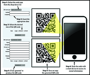
QR codes are 2D, scannable matrices composed of a unique combination of pixelated squares. At the most basic level, they are capable of storing calendar events, contact details, URLs, text and geo-locations. While similar in function to barcodes, QR codes offer additional benefits; namely, their ability to store more than 7000 digits, whereas a barcode is limited to 20 (Crompton et al. Reference Crompton, LaFrance and van ‘t Hooft2012). They also have 30 per cent error correction capabilities, meaning that if up to 30 per cent of the code is impaired, damaged or obstructed, data may still be recovered (Latzko-Toth & Barnhurst Reference Latzko-Toth, Barnhurst, Latzko-Toth and Millerand2012). Other benefits include rapid scanning times, their comparatively small size when compared to traditional labels (Kiryakova et al. Reference Kiryakova, Angelova and Yordanova2013), decreased processing time (Smith & Levy Reference Smith and Levy2012) and a reduction in registrar errors, as well as the avoidance of illegibility and inconsistency in hand-writing styles (see Martínez-Moreno et al. Reference Martínez-Moreno, Marcén and Torcal2011). Reading or generating QR codes can be performed using freely available programs downloaded onto any smart device. To create a code, the required information is entered into a data tab and a unique matrix is automatically generated (Figure 1). QR codes are thus ideal for supplying viewers with information and providing links to content.
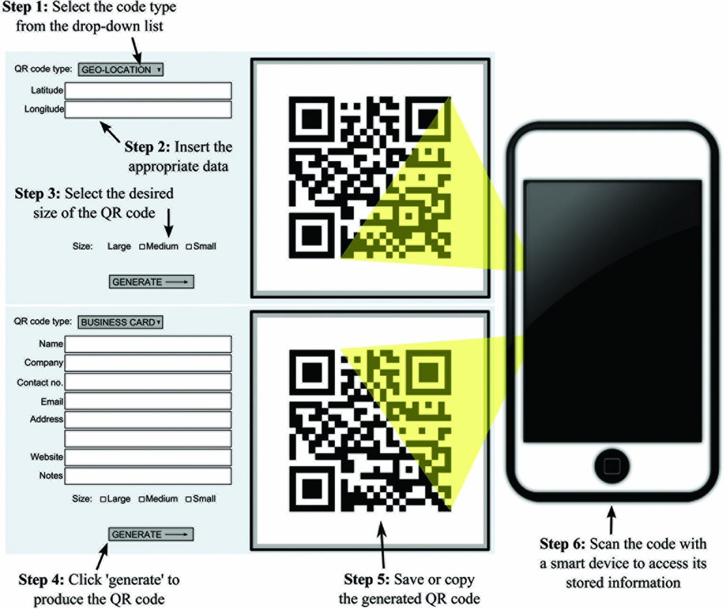
Figure 1. An adapted diagram showing how to produce QR codes. To create a QR code, the type of code must be selected (only two types are illustrated here) and the data tabs will change accordingly. When ‘Generate’ is selected, the QR code will be produced and appear in the space provided.
Applications of QR codes in heritage fields
In heritage fields, QR codes have been implemented in a number of different contexts, including libraries (MacDonald Reference MacDonald2012), museums (Farina et al. Reference Farina, Paganucci and Landini2011) and archaeological sites (Mazel et al. Reference Mazel, Galani, Maxwell and Sharpe2012; Galani et al. Reference Galani, Mazel, Maxwell, Sharpe, Ch'ng, Gaffney and Chapman2013). The use of QR codes in archaeological research, however, is currently limited. In southern Jordan, Smith and Levy (Reference Smith and Levy2012) employed a geographic information system (GIS) program that used QR codes to record contextual information. In a similar application of digital technology, Martínez-Moreno et al. (Reference Martínez-Moreno, Marcén and Torcal2011) used data matrix (DM) codes to record specific artefact contexts. DM codes are similar in appearance to QR codes, but they cannot hold as much data. The team printed 3 × 3mm DM codes on polypropylene, to ensure their preservation, and used an adhesive to attach them to an artefact. They recorded less than 0.2 per cent information loss on 10 000 stone and bone tools, a significant reduction when compared to hand-recorded notes. In a similarly exhaustive use of codes, Dibble et al. (Reference Dibble, Marean and McPherron2007) used barcodes at Roc de Marsal, France, and Mossel Bay, South Africa, to link an object with its 3D features. QR codes can be used in a similar way, and were preferred for research at Telperion Shelter because of their superior data storage capacity.
Implementing QR codes at Telperion Shelter: an archaeological application
Telperion Shelter is a west-facing overhang situated along the eastern side of the Wilge River (Figure 2). Recording the site's rock art involved establishing 12 blocks or zones based on the topography of the rock face and the presence of rock art images. Areas with no rock art were not included. Blocks were labelled A–K from south to north, with block L being created after the grid had been set up when new art was located on the southern wall beyond block A. Each block was then further divided by superimposing over it a grid composed of 500 × 500mm squares to control spatial relationships. Within this structure, images were identified and counted. The painting tradition of each image was determined according to the known rock art of various cultural groups, as well as by considering the techniques and colours used. In total, 279 images were identified, of which 124 can be considered graffiti; these being written texts, recent drawings, and depictions made during the South African War when the site was used as a refuge camp (Forssman & Louw in press). The most active artists at the site, however, appear to have been Sotho-Tswana occupants (n = 133), whose artwork is known as the Late White tradition. The art of the Khoekhoen (n = 12), which consists mostly of finger dot and cluster motifs, and San (n = 8), fine-lined animal depictions, occurs in low frequencies (see Mitchell Reference Mitchell2002 for a general overview of art traditions). The purpose of this paper is not to present the rock art itself, which is the topic of another study, but to demonstrate how QR codes can be used to assist in archaeological fieldwork for the benefit of others seeking to implement such technology in their research.

Figure 2. Telperion Shelter with a QR code linked to A) the location of Telperion Shelter using Google Earth, and B) a schematic of the rock art panel and blocks. Scan the QR code with an appropriate scanner to access its stored content.
A preliminary recording of Telperion Shelter's rock art was made during an earlier visit, making it possible to produce QR codes with spatial information before our return. This allowed us to pre-print codes, eliminating the need for additional equipment to produce and print them in the field (discussed below). We used a bulk QR code online generator (www.qrexplore.com) to produce a large number of codes quickly. Selected data, such as spreadsheets or lines of text, are entered into a dialogue box—it is important to place all of the data that are to be embedded in a single code on the same line, as the program produces a unique code for each line of information. When all the data have been entered into the dialogue box, specifications such as size, pixels per block and error correction level are selected. When ‘Generate codes’ is selected, the codes will then be available for downloading in a .zip file. Using this method, multiple codes can be produced with speed and ease; the examples in Figure 1, by contrast, are designed only to produce single codes.
With the code containing the appropriate contextual or spatial data generated, they were placed within the image when photographing the rock art. For example, we used QR codes in four different phases. Phase one (shown in Figure 2) was the site itself and contained two QR codes linking to the site's location on GoogleEarth through GPS co-ordinates embedded in the code (Figure 2A), and a schematic of both the site and rock art panel (Figure 2B). During phases two and three, photographs of the blocks and their gridded squares were taken, each containing a QR code linking the image to its spatial location within the site grid. Lastly, phase four pertained to images or image clusters for tracing at a later stage, and each image or cluster was given a QR code that contained a square code and information on the panel and its importance. Phases two, three and four are discussed in greater detail, demonstrating how QR codes assisted with each phase.
The use of QR codes at phase two demonstrates the value of their application beyond recording contextual details and reducing the probability of error and processing time. As an example of this, Figure 3 shows a composite image of the entire panel created by combining seven images of the site upon which blocks were demarcated using a polygon function in Inkscape. Embedded within each block on the composite image is a QR code that links the reader to a more detailed image of the specific block stored on Google Drive, and which contains contextual information. By doing so, the reader is provided with additional information without taking up further space within the paper, and has the option to ‘opt-in’ with the added data, enhancing the paper with information that may otherwise have been excluded. The use of such a method may reduce the number of figures within a manuscript while still making them available to any reader equipped with a smart device. In this way, QR codes can improve the efficiency and communication of data in scientific papers. It does, however, provide an aesthetic and functional challenge: unlike in Figure 3, where the goal was merely to demonstrate the utility of QR codes, obscuring the image can, in some cases, be problematic, meaning an alternative way of presenting matrices alongside a figure is required (e.g. Figure 2).

Figure 3. Polygons outlining each block have been added to this composite image of Telperion Shelter's rock art. The QR codes link to detailed images of each block. The observer is able to view the relationship between a block, the shelter and other blocks by scanning the codes.
Phase three involved photographing each square within a block's grid. The purpose of this exercise was to obtain detailed images of the entire panel for a digital reconstruction of the site. Photography was conducted in three stages per square: the first image contained a QR code, the second a colour bar and scale and the last provided an unobscured view. Each QR code contained a three-part context number, detailing a numerical reference code (e.g. 1), an acronym of the site (TS) and the square's details (e.g. A1 for block A, square 1), thus appearing in the format of ‘1 TS A1’ when scanned. While it is possible to pre-print labels, QR codes immediately store data online, eliminating the possibility of losing data. Hand-written notes were also taken for comparative purposes, recording the date, time, camera ID, reference code, block, square, photographic stage and image-tracing potential. It was found that using QR codes significantly decreased processing time, making it possible to complete the study within a shorter timeframe. In 55 squares, not a single error was recorded, although it must be acknowledged that had codes been generated in the field, there may have been a greater possibility of errors.
Phase four involved the identification and recording of art at the site to be traced digitally using image-enhancement software and Inkscape. Images were selected based on content, technique, superpositioning (layering of images), sequencing and painting traditions. Each image identified for tracing was given a QR code with a block and numerical reference (e.g. T C1 = tracing block C, number 1), and in Figure 4 these have been placed onto the site composite image of Telperion Shelter, linking the reader to a full-frame image of the actual section. The use of QR codes in this phase enables the researcher and reader to obtain a greater degree of contextual awareness. Doing so greatly increases the transparency of the study as QR codes added to the traced image, linking the reader with the actual photograph of the artwork, allow for an assessment of the tracing's representativeness (e.g. Figure 5). Similar to this application of QR codes, such an approach may also be adapted for recording and presenting stratigraphic schematics.
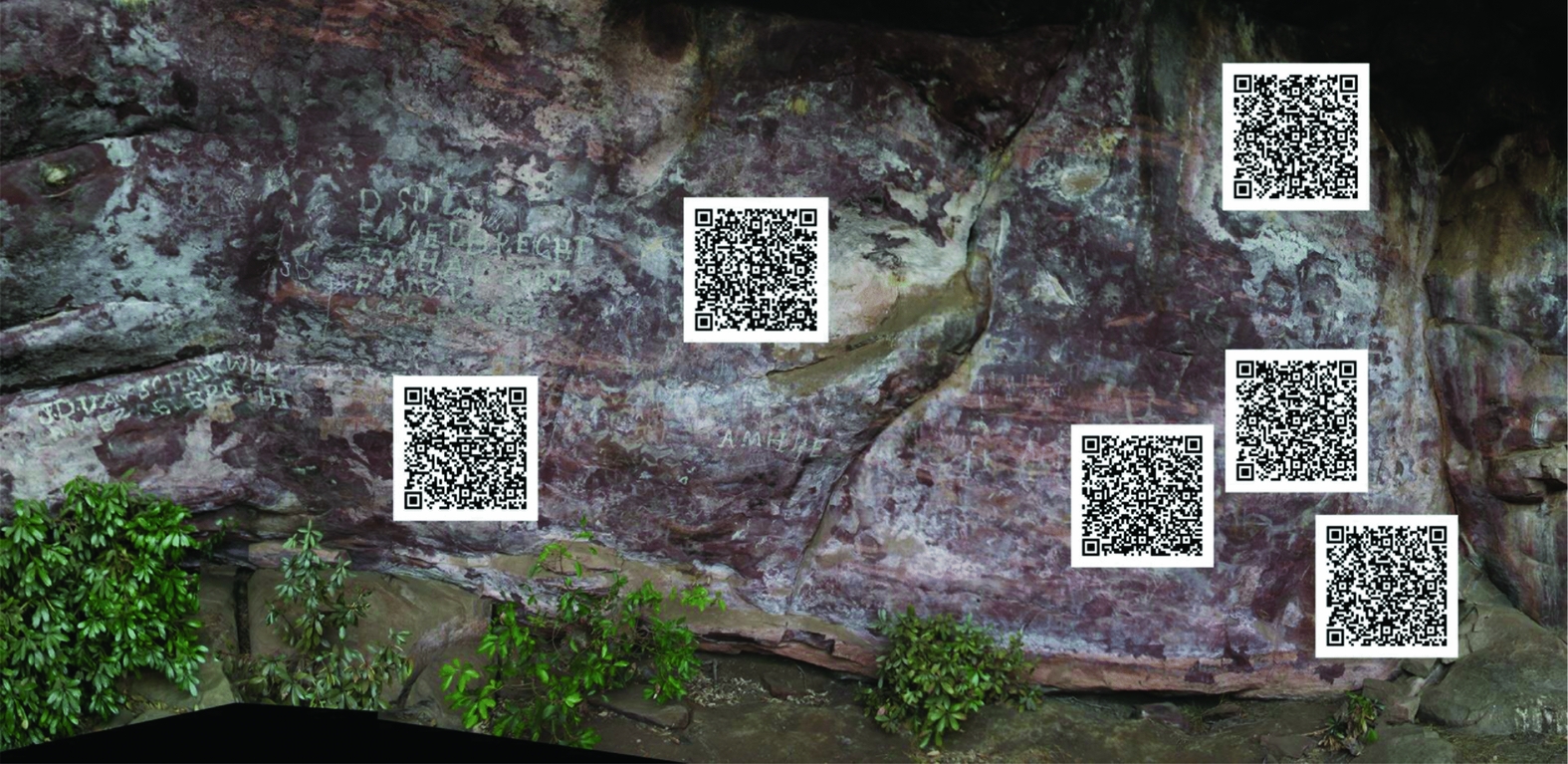
Figure 4. A portion of Telperion Shelter with QR codes linked to tracing panels. Scanning the code provides the viewer with a detailed image of the panel to be traced.

Figure 5. Present here are: South African War-period (1899–1902) figures in white crayon; more recent graffiti; and Sotho-Tswana artwork in the form of a procession of animals, an apron and humans, all depicted in white. Scan the QR code to see a photograph of the actual painting.
A critical appraisal of QR codes
Several issues were identified in the use of QR codes that require addressing. First, without access to electricity in the field, codes must be pre-printed, limiting the amount of data per code because specific contextual details cannot be known until fieldwork has begun. This can, however, be overcome quite easily by generating a QR code on a smart device with an internet connection, and using the device to display the code. This reduces paper use, costs and, with photographic editing programs, can be removed from the final image or adjusted if required. At some sites, there may be facilities to print them immediately on location (see Dibble et al. Reference Dibble, Marean and McPherron2007).
Second, although reading QR codes can be done relatively rapidly, they must be flat and largely unobstructed, despite their built-in correction for error. In Telperion Shelter, certain panels were located several metres above ground level, and a staff with the QR code attached to the end was needed to place the code within the photograph's frame. Once in the laboratory, it was noted that when the QR code was not held flat or was slightly curved around the staff, reading the code became difficult; and in such cases where this is unavoidable, the risk of losing information would make conventional field notes a valuable insurance. Using a rigid plastic sleeve or something similar might present a simple solution to this potential problem.
Third, large QR code prints could potentially obstruct images on the rock art panel. QR codes for phases two and three were fairly small (30 × 30mm) but sufficiently sized to ensure that capturing them through a photograph was possible. Codes used to record an image or image clusters for tracing, however, were larger (47 × 47mm), improving processing speed when scanning the code, but also posing a potentially greater obstruction. Lastly, variable error correction settings are possible when generating QR codes. The highest is recommended because the matrix will comprise a more complex pattern of smaller pixels, enhancing the matrix's readability.
In addition to the above issues, two concerns unrelated to the practical use of QR codes are the time spent in direct contact with the material, site or landscape, and the future-proofing of the matrix. With an increase in on-site record processing, less time is spent engaging with the site under investigation. While this was the case in the study referenced here, it would not necessarily be true for other projects. For example, using QR codes to record sites identified in archaeological surveying, or the features of an excavation, will not affect the time spent performing these tasks. In contrast, QR codes can potentially increase contact with the site by providing the reader with data, figures or features of the site that would not normally be published, thus increasing active engagement with the material. QR codes can also provide access for site visitors to information in different languages, thus expanding the social relevance of a site by including communities that previously may have been excluded but who might have vested interest in the site. In such cases, QR codes may arguably deepen the relationship between site, data and observer. Perhaps then, QR codes have the most to offer to data presentation. Using such matrices in conference outputs, especially posters, links the audience to additional resources and figures, publications or other online materials.
This technology may, however, fall out of favour or be replaced by a more efficient system. If this were to happen, QR code readers would still be available, and as embedded information stored in the code has an unlimited lifespan, the data would not be lost. Problems arise if a URL, used to store data or figures, is then discontinued, resulting in the loss of information. Using online programs such as Google Drive or Dropbox negates this risk and are also cost free, at least with regard to the aforementioned. Nevertheless, the user must be cognisant of the fact that long-term online data storage is problematic. Despite these reservations, we feel that the use of QR codes, in such a way as to either link the observer to site details or non-essential data, figures or online resources, enhances the presentation of archaeological studies.
Final remarks
The use of QR codes in archaeological research enhances studies by improving the accuracy of site records, and by posing an efficient alternative to conventional recording methods. The benefits that QR codes offer archaeologists include: a) the ability to record information rapidly and reduce the occurrence of errors; b) the availability of free code-generating and -recording applications; c) the safe storage of data that are immediately loaded online or stored in the code itself; d) a reduction in the amount of paper used in recording contextual information; and, importantly, e) its ability to augment publications by allowing the reader to view additional or non-essential information, enhancing the content of research. The use of QR codes at Telperion Shelter highlights some of these benefits, showing that the tool's application in archaeological research is easily achieved and, even at a basic level, can considerably enhance research and the presentation of findings.
Acknowledgements
We thank Duncan MacFadyen and the De Beers Diamond Route for access to Telperion Shelter, and Elsabe Bosch (Telperion) and Maroti Tau (Ezemvelo) for their help. We acknowledge the support given by the Palaeontological Scientific Trust and their ‘Scatterlings of Africa’ programme, as well as South Africa's National Research Foundation. We also thank our field assistants, Natasha van der Nest and Nicole Schutte, and Matt Lotter, for help with Figure 3.


