


Introduction
Angkor (Figure 1), the location of the urban complex of Greater Angkor (Figure 2), and the capital of the Khmer empire between the ninth and the fifteenth centuries AD, is home to hundreds of temples and shrines built between the seventh and sixteenth centuries. The iconic temple of Angkor Wat, built in the early twelfth century (Cœdès Reference Cœdès1920), is one of the most beautiful religious buildings in existence (Figure 3), and is generally considered to be the largest such structure erected before the twentieth century AD. The splendour of the temple at the pinnacle of the Khmer empire in the twelfth century is indicated by an inscription made in the temple (on a pillar in the cruciform gallery) in 1579, after the old empire had faded away, which refers to a Khmer ruler who, even then, could engage in ‘regilding the towers’ (Santi Reference Santi2008).

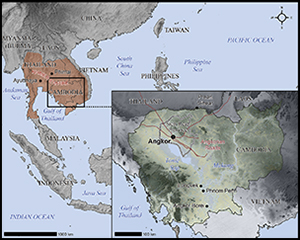
Figure 1. Regional map of Southeast Asia showing the approximate maximal extent of the Angkor Empire; inset bottom right: map of Cambodia including the Angkor-period road network emanating from Angkor (data courtesy of NASA-SRTM, JICA and Mitch Hendrickson).

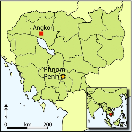
Figure 2. Overview map of Greater Angkor and the water catchment area, including sites mentioned in this paper; inset top left: regional view; inset bottom left: detail of the central urban area (data courtesy of NASA-SRTM, JICA, Damian Evans and Christophe Pottier).

Figure 3. View over Angkor Wat from the west, looking towards the Kulen hills; the extent of one quarter of Greater Angkor is indicated by the distance between Angkor Wat and the north-eastern outer edge of the urban complex near the grey line of the base of the hills (photograph courtesy of Mike Coe).
Unlike most other Angkorian temples, Angkor Wat faces west, probably because it was originally dedicated to Vishnu (Cœdès Reference Cœdès1940: 343). While the original name of the monument remains unknown, we do know that Angkor Wat is most certainly a later name, as the urban area around it was called Yasodharapura from the late ninth century, and only became known as Angkor after the fifteenth century (Groslier Reference Groslier2006: 74). In the 1290s, Zhou Daguan, a Chinese visitor who described Angkor, referred to Angkor Wat as the ‘Tomb of Lu Ban’. Lu Ban is a famous mythical Chinese builder, which suggests that the name by which it was then known referred to a funerary function, apparently connected to the name given by the Khmer at that time to its divine architect (Zhou trans. 2007: 48). From 1557, Cambodian texts (Santi Reference Santi2008: 41) refer to the temple as Brah Bisnuloka—a restatement of the posthumous name of the king who built it and of the memory of its original cult of Vishnu, even though by then Angkor Wat was principally used as a Theravada Buddhist shrine. The name Angkor Wat was in use by 1632 (Groslier Reference Groslier2006: 74; Santi Reference Santi2008: 42), but it cannot tell us about the temple's original function, context or the residential status of its enclosure in the twelfth and thirteenth centuries. The integration of Angkor Wat into the central area (c. 1000km2) of the low-density urban complex of Greater Angkor (Pottier Reference Pottier and Manguin1998; Fletcher et al. Reference Fletcher, Barbetti, Evans, Than, Sokrithy, Chan, Penny, Pottier and Somaneath2003; Evans et al. Reference Evans, Pottier, Fletcher, Hensley, Tapley, Milne and Barbetti2007) means that its residence pattern informs us about the configuration of Angkorian urbanism, and refutes the conventional model of the development of Angkor as a series of successive, small, walled cities (Pottier Reference Pottier2000; Evans et al. Reference Evans, Fletcher, Pottier, Chevance, Soutif, Suy, Sokrithy, Darith, Tina, Samnang, Cromarty, De Greef, Hanus, Bâty, Kuszinger, Shimoda and Boornazian2013; Evans & Fletcher Reference Evans and Fletcher2015).
For more than a century, with the exception of the period from the 1970s to the mid-1980s, Angkor Wat has been a focus of scholarly research, restoration and conservation, especially by the French. The dominant intellectual concerns have been the art, iconography, ritual function and architecture of the monument. The results of recent archaeological research, reported in this issue of Antiquity, have revealed several new and surprising insights. The Angkor Wat complex was far larger than expected (Figures 4 & 5), had more components than previously envisaged and was bounded on its south side by a unique and massive structure with dimensions of more than 1500 × 600m: the ‘rectilinear spirals’ (Figure 6). The function of this structure remains unknown and has, as yet, no known equivalent in the Angkorian world (Evans & Fletcher Reference Evans and Fletcher2015). The fourth (outer) enclosure contains a grid of roads, ponds and mounds, with far more housing than was previously known, although it was not densely inhabited (Stark et al. Reference Stark, Evans, Rachna, Piphal and Carter2015). The architectural history of the temple is far more elaborate than was originally presumed, and includes an entire ensemble of towers on the axis of the west side of the fourth enclosure, which were built and demolished during the construction and initial use of the main temple (Sonnemann et al. Reference Sonnemann, O'Reilly, Rachna, Fletcher and Pottier2015). Angkor Wat was also fortified sometime later in its Angkorian history, with wooden platforms and palisades along the upper part of the old outer wall of the fourth enclosure (Brotherson 2015).

Figure 4. An orthophotograph of Angkor Wat taken during the LiDAR survey in 2012 (image courtesy of KALC).

Figure 5. A preliminary archaeological map of the Angkor Wat area based on an analysis of LiDAR imagery (data courtesy of Damian Evans).

Figure 6. Reconstruction image of Angkor Wat on the basis of the LiDAR images and recent fieldwork by the Greater Angkor Project (image courtesy of Tom Chandler, Monash University).
Angkor Wat
Angkor Wat is located between, and to the south of, the two great reservoirs: the East Baray (constructed in the late ninth century) and the West Baray (constructed in the early eleventh century) (see Figure 2). The temple is considered to have been built for Suryavarman II during his reign from AD 1113–1149 (Claude Jacques pers. comm.; Cœdès Reference Cœdès1920; cf. Southworth Reference Southworth, Karlström and Källén2003). Suryavarman II came from a family that probably originated near Phimai, in what is now north-east Thailand and was then part of a province of the Khmer Empire. He was the third ruler of the Mahidharapura dynasty in Angkor and came to power by violence, killing his uncle Dharanindravarman I, and reunifying the Khmer Empire (Cœdès Reference Cœdès1929: 302–303). The coronation of Suryavarman II, mentioned in an inscription at Preah Vihear (K. 383), was officiated by the purohita (high priest) Divakara, who had legitimised the three previous rulers from two different dynasties. Divakara was honoured by Suryavarman II sometime between AD 1119 and 1121 with the most eminent title of ‘dust of the feet’ (Cœdès & Dupont Reference Cœdès and Dupont1943–Reference Cœdès and Dupont1946). Angkor Wat is considered to be both a Vishnuite temple in its original form and the funerary monument of Suryavarman II. His posthumous name, Paramavishnuloka, is the only textual reference to him in the entire monument.
As with most major Angkorian temples, Angkor Wat was never fully completed. Some of the gallery walls are incompletely carved or undecorated. Parts of the exterior wall decoration are also unfinished. Given that the primary construction of such a temple most probably occurred within a single ruler's reign, building Angkor Wat presumably took about 40 years. From its inception to the present day, the temple area has been used for ritual purposes: first Hindu in the twelfth and presumably thirteenth centuries, and then Buddhist, most probably from the fourteenth or fifteenth centuries onwards. In the later period, the temple was considerably renovated with repairs and modifications to the western gateway and the central tower cluster. These included the closing of the four doors to the central shrine, the walls of which were sculpted with standing figures of Buddha (Marchal Reference Marchal1928: 79–80; Glaize Reference Glaize1944: 89–90; Thompson Reference Thompson2004). From the sixteenth century, many inscriptions were added to its walls, celebrating pious foundations and statue installations (Giteau Reference Giteau1975: 151–56). The bas-reliefs of the eastern end of the north outer corridor and the northern end of the east outer corridor were completed in the mid-sixteenth century (Cœdès Reference Cœdès1962; Giteau Reference Giteau1975: 93–111). Paintings of seventeenth- and eighteenth-century ships were also added to the walls of several galleries (Walker Vadillo Reference Walker-Vadillo2009, Reference Walker-Vadillo2014; Tan et al. Reference Tan, Sokrithy, Than and Chan2014).
The construction is even larger than can be readily seen. An east–west cross-section profile across Angkor Wat, derived from the LiDAR survey (Figure 7) and combined with extensive coring by the APSARA National Authority (Authority for the Protection and Management of Angkor and the region of Siem Reap), shows that the masonry structure of the temple is built on a platform of approximately 3 million cubic metres of fill. This platform, which was constructed from layers of sand and clay, is relatively shallow at its northern side and over 4m high on the southern side, forming a horizontal surface above a former ground level that originally sloped from the north-east to south-west. Part of this huge substructure is the massive dam, over 50m wide and more than 5m high, which delimits the southern portion of the 200m-wide moat.

Figure 7. East–west profiles of ground surface across the platform, moats and dams of Angkor Wat; profiles from 2012 LiDAR survey, prepared by Kasper Hanus; location of clay layers from coring directed by Chhay Rachna.
The masonry structure of the central temple consists of a sand core, encased in a pyramid of precisely positioned laterite blocks, which are in turn covered by sandstone blocks that were then elaborately carved. The construction produced enormous quantities of sandstone chips that form the substrate of the level ground around the temple and along either side of the outer enclosure wall. The main temple consists of a central, raised group of five towers, a quincuncx, with four towers in a square 75 × 75m, surrounding a symmetrically placed central tower. Outside this first enclosure is a second, measuring 100 × 115m, with towers at each corner. Surrounding that is a continuous rectangular gallery running around all four sides of the temple and forming the third enclosure, 215 × 187m, which stands on a terrace of 340 × 270m. The main temple sits in the middle of an open area, the fourth enclosure, and is connected to the western entrance by a 15m-wide causeway. The fourth enclosure is 1000 × 815m and is bounded by a laterite wall over 4m high that was built when the four gopura, or roofed gateways, were completed during the latter stages of the temple's construction. Between the enclosure wall and the moat is a flat area c. 35–40m across. The moat is 200m wide and its outer perimeter extends 1500m from east–west and 1300m from north–south. Both sides of the moat are faced by a continuous kerb of large, carved, sandstone slabs that cap the sandstone and laterite steps.
Angkor Wat was an elaborate ritual, iconographic and cosmological construct (Roveda Reference Roveda2002). The complexity and sophistication of the monument is apparent in many ways, from remarkable visual effects to intensely abstruse geometry. Such an effect occurs when the late afternoon sun shines through the carved pillars in the windows of the galleries, producing shadows in the shape of the central towers from the profiles of the pillars, and is repeated thousands of times down the corridors (Figure 8). As with other Khmer temples, the main temple is not quite symmetrical. For example, in the western and eastern frontages, the gallery on the north side has 20 pillars whereas the southern one has 18. This feature cannot be accidental. The reason for the asymmetry is unclear, although Kak (Reference Kak1999: 119 & 122) has proposed that an asymmetry in the axes of the central tower relates to the temporal asymmetry of the two parts of the year in Satapatha astronomy. Another proposal concerning temporal cosmology was made in the 1970s by Robert Stencel and colleagues, suggesting that the divisions between the sectors of the main western causeway of Angkor Wat correspond to the proportional duration of the successive yuga, or ages, of the Hindu cosmology (Stencel et al. Reference Stencel, Gifford and Moron1976: 786). On a physically grander scale, the entire layout of Angkor Wat—as with all the major state temples, a pyramid mountain surrounded by a moat—is considered to correspond with the cosmology of Mount Meru and the surrounding Sea of Milk from which ambrosia was churned by the gods and demons (Glaize Reference Glaize1944: 36–38; O'Naghten Reference O'Naghten2000).

Figure 8. Shadows in the shape of the central towers of Angkor Wat produced by the late afternoon sun shining through the carved pillars in the windows of the galleries (image courtesy of Christophe Pottier).
Beyond the immediate vicinity of the temple, Angkor Wat was also enmeshed within the cosmology and symbolism of the urban landscape and the water network (see Figure 2). Two shrines of the Angkor Wat style, Thommanon and Chau Say Tevoda, lie on either side of the east–west axial road between the Royal Palace and the East Baray. Farther east, the shrine of Banteay Samre was located at the south-east corner of the East Baray, and beyond the baray, the road to the east (see Figure 2) continues through another shrine in the style of Angkor Wat at Chau Srei Vibol, which forms an eastern boundary to Greater Angkor. To the west, the great reclining statue of Vishnu, which was located on the West Mebon in the middle of the West Baray, is known to have superseded an earlier configuration consisting of a large, upright, cylindrical stone column (Pascal Royère pers. comm.). The statue, which is conventionally ascribed to the mid-eleventh century because of its Baphuon style, may instead have been emplaced in the early twelfth century as part of a resumption of the ritual and water management landscape in the reign of Suryavaraman II (Feneley Reference Feneley, Klokke and Degroot2014). Not only was Angkor Wat an immense ritual construction, it was integral to the presentation of power in Angkor and, also, to the operation of the water network and hence urban landscape of Greater Angkor. The moat of Angkor Wat now has a channel associated with its eastern causeway (visible in Evans et al. Reference Evans, Fletcher, Pottier, Chevance, Soutif, Suy, Sokrithy, Darith, Tina, Samnang, Cromarty, De Greef, Hanus, Bâty, Kuszinger, Shimoda and Boornazian2013: fig. 3) and three others through the northern edge of the moat, indicating connections to both the eastern and western parts of the water network, stretching across Greater Angkor. At the south-west corner of the moat, a canal runs for more than 13km from north–south, crossing the entire southern half of Greater Angkor down to the potential port site at Phnom Krom on the edge of the great lake, the Tonle Sap.
The significance of Angkor Wat in the urban development of Greater Angkor
Angkor Wat is integral to the debates about the urban form of Angkor and the places where people lived when the capital of the Khmer Empire was at its height in the twelfth to thirteenth centuries. Throughout the nineteenth and twentieth centuries, the prevailing view of the development of medieval Khmer urbanism—one that has been generally accepted in the literature—was that Angkor consisted of a succession of small walled and/or moated centres arrayed neatly around great state temples, the last of which was the twelfth to thirteenth century AD walled enclosure of Angkor Thom with the Bayon at its centre. In this conventional view, Angkor Wat was a city, the capital of Angkor in the early-to-mid twelfth century AD, immediately preceding Angkor Thom. The standard assumption has generally been that the enclosed spaces of Angkor Wat and Angkor Thom delimited ‘cities’ or ‘towns’. In this view, walls, moats or the limits of large-scale religious/hydraulic infrastructure—essentially, the ‘sacred geography’ of Angkor—defined self-contained, spatially discrete, ‘urban’ areas. These intramural spaces are supposed to have housed the bulk of the urban population, including the ruler's palace, and are considered to have been substantially different from the extramural landscape, which consisted of an extended rural-agricultural hinterland with scattered and isolated shrines and villages (Jacques Reference Jacques1978; Moore Reference Moore1989; Jacques & Freeman Reference Jacques and Freeman1997; Briggs Reference Briggs1999 [1951]; Higham Reference Higham2001; Gaucher Reference Gaucher2004; Jacques & Lafond Reference Jacques and Lafond2007).
The premise has been that cities are, by definition, densely populated, clearly delimited and quite different from the rural landscape. Given that modern, low-density, dispersed, industrial cities in southern and eastern Asia are labelled ‘desa-kota’ or ‘rural-urban’ (McGee Reference McGee, Ginsburg, Poppel and McGee1991), the conventional definition is inadequate. Indeed, there is no agreed definition of agrarian-based ‘urbanism’ (Storey Reference Storey and Storey2006: 2), and given the dispersed pattern of much industrial urbanism, a low-density configuration has to be included in any general specification (Fletcher Reference Fletcher and Smith2012; Lucero et al. Reference Lucero, Fletcher and Coningham2015).
The conventional notion of a formal urban/rural dichotomy in Angkor is seldom made explicit in the literature. Gaucher's (Reference Gaucher2004) argument for Angkor Thom as a ‘genuine urban area’ is a very rare treatment of the issue. Nonetheless, the idea is pervasive in works on Khmer history and archaeology, even if subtly so, as evidenced by the amount of effort that has been spent dismantling specific stages of the apocryphal ‘sequence of enclosures’ (Pottier Reference Pottier2000, Reference Pottier2003, Reference Pottier2006; Evans et al. Reference Evans, Pottier, Fletcher, Hensley, Tapley, Milne and Barbetti2007; Evans Reference Evans2013) and arguing for a more nuanced view of the urban-to-rural transition (Groslier Reference Groslier1974, Reference Groslier1979; Fletcher & Pottier Reference Fletcher and Pottier2002; Pottier Reference Pottier2006, Reference Pottier and Haendel2012; Fletcher Reference Fletcher2009, Reference Fletcher and Smith2012; Evans et al. Reference Evans, Fletcher, Pottier, Chevance, Soutif, Suy, Sokrithy, Darith, Tina, Samnang, Cromarty, De Greef, Hanus, Bâty, Kuszinger, Shimoda and Boornazian2013). The conventional idea of ‘temples-as-cities’ is perhaps understandable in the context of earlier scholarship on Angkor, as the moats of many temples enclose areas as large as medieval European towns. Medieval Leiden in the Netherlands, for example, would fit comfortably within the moat perimeter of Angkor Wat (Figure 9). In the late twelfth to early thirteenth centuries, following the construction of Angkor Wat, and during the period in which, conventionally, the walled and moated 9km2 space of Angkor Thom is defined as the limits of the capital, the enclosures of Preah Khan and Ta Prohm—covering 56 and 60ha respectively, and located a mere 1 or 2km from the moat of Angkor Thom—are themselves referred to by scholars as separate ‘towns’ or ‘cities’ with their own populations, putatively of thousands of inhabitants (Jacques & Freeman Reference Jacques and Freeman1997; Jacques & Lafond Reference Jacques and Lafond2007). This is a view that follows from the first analysis of the Preah Khan inscription (Cœdès Reference Cœdès1941), and perhaps accords with the culturally specific, indigenous definition of a central locality, ‘pura’, during the Angkor period. The source also states, however, that the total workforce includes those resident within a temple enclosure (Cœdès Reference Cœdès1941; and see English translation by Maxwell Reference Maxwell2008), and thus, as a corollary, excludes others of the working population who must have resided outside. The large staff populations for the temples, e.g. 12 640 for Ta Prohm in the 1180s and 1190s (Cœdès Reference Cœdès1906), do not tell us the size of the resident population within the temple enclosures. In addition, now that the number of ponds within the temple enclosures can be identified from the LiDAR images and with the use of Zhou Daguan's report to calculate maximum population estimates (based on up to three families sharing a pond), it is apparent that the residents within each enclosure only numbered a few thousand at most (Evans & Fletcher Reference Evans and Fletcher2015: 1408, 1410–11; Stark et al. Reference Stark, Evans, Rachna, Piphal and Carter2015: 1444 & 1450). As these temples were embedded deep within Greater Angkor—an urban complex containing up to 750 000 people, where many thousands of them would have been living in the central urban area both inside and outside Angkor Thom—the individual temple enclosures cannot therefore be defined as separate, discrete or successive towns or cities. Equally, the moated enclosure of Angkor Wat was not a relatively small, separate walled city, surrounded by countryside, which was supposedly superseded in the 1180s after less than half a century by the enclosure of Angkor Thom, about 1km to the north. Instead, the significance of Angkor Wat lies in the fact that it was an immense temple, inserted into the complex, urban and hydraulic networks of the vast, long-lasting, low-density city of Greater Angkor. Together, they were the largest ritual and urban phenomenon the world would see for 700–800 years.

Figure 9. The comparative extent of Angkor Wat and the medieval walled town of Leiden in the Netherlands (after Jacques and Leiden Municipal Council).
Conclusions
The recent research reported in the Angkor Wat papers in this issue of Antiquity demonstrates that our knowledge of even a well-known, extensively investigated and frequently visited monument can be transformed by archaeological inquiry. The results are a profound display of the power, relevance and necessity of archaeology. They redefine Angkor Wat's history, geographical extent, architectural configuration, residence pattern and population, overall function and its relationship to the urban landscape of Angkor. In addition, the huge, unique and problematic structure of the ‘rectilinear spirals’, has never previously been recognised or even predicted, or supposed, and it still defies explanation. That structure has been traversed by numerous researchers and millions of tourists since the 1860s, illustrating both the liability that we tend not to observe what we do not expect and the capacity of archaeology, and especially of remote sensing, to allow us to see the unexpected.
Note
The Greater Angkor Project is an international collaboration between APSARA National Authority of Cambodia, the EFEO—l'École française d'Extrême-Orient, which has worked on Angkor for over a century—and the University of Sydney in Australia, which has funded the project primarily through the support of the Australian Research Council. The joint team has worked in Angkor since 1998, with the aim of identifying the extent and spatial organisation of Angkor, the operation and development of the water-management network and the demise of the urban complex of Greater Angkor. Since 2010, a team from the University of Hawai‘i has joined the project to study domestic consumption and production. The authors of this paper and the other four Angkor Wat papers in this issue of Antiquity all are, or have been, members of the Greater Angkor Project.
Acknowledgements
Many thanks to the University of Sydney, and in particular to Martin King in Sydney and Malay So at the Robert Christie Research Centre of the University of Sydney in Siem Reap; to the EFEO for support and assistance over many years; and to the ASPARA National Authority for support and for permission to work in Angkor. The work of the Sydney members of the Greater Angkor Project has also been generously supported by the Australian Research Council—ARC Discovery Grant DP 1092663 and by previous ARC grants. Roland Fletcher particularly wishes to thank Lee Seng Tee for his gracious support over many years.


