


The arid Peruvian coastal landscape is rich with anthropogenic pre-Columbian features. Of these, pathways and geoglyphs—designs created on the ground by moving stones or earth—are readily visible due to their size and distinctive shapes. These features have often been studied independently, with pathways typically seen as transportation networks, and geoglyphs framed primarily as representing ritual behaviour (Beck Reference Beck1979; Hyslop Reference Hyslop1984; Linares Málaga Reference Linares Málaga1999; Aveni Reference Aveni2000; Jenkins Reference Jenkins2001; Hostnig Reference Hostnig2003). Yet movement between places was, and remains, heavily ritualised in the Andes (Flores Ochoa Reference Flores Ochoa1979; Christie Reference Christie2008; Núñez & Nielsen Reference Núñez and Nielsen2011), and archaeologists have anecdotally noted close associations between inter-valley pathways and anthropogenic features, such as geoglyphs and other types of rock art. The famous Nazca Lines, for example, may have begun as elaborations of footpaths that crossed the desert pampa, with geoglyphs of llamas probably serving as ‘guideposts’ along caravan routes in far southern Peru (Goldstein Reference Goldstein2005: 14; Ruggles & Saunders Reference Ruggles and Saunders2012: 1136). To our knowledge, however, none of these probable spatial associations between geoglyphs and pathways have been evaluated in a systematic, quantitative manner.
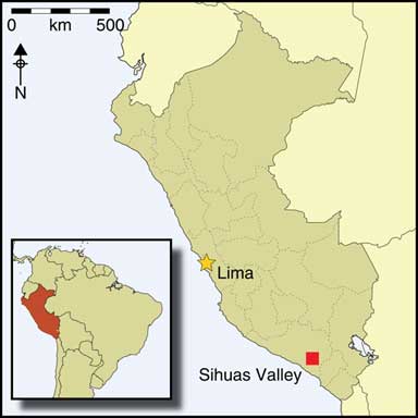
Here, we present the results of a study of the relationship between pathways and geoglyphs on the pampa above the Sihuas Valley in southern Peru (Figure 1). At the end of the Middle Horizon Period (AD 650–1050), local population expansion led to the extension of a network of pathways on the Sihuas pampa. Due to environmental conditions and relatively limited human impact since the Spanish conquest of the mid sixteenth century AD, these pathways can be studied in relation to surrounding geoglyphs and other anthropogenic features. Since 2014, we have surveyed the landscape surrounding the site of Quilcapampa (Figure 1) using a combination of high-resolution satellite imagery, unmanned aerial vehicle (UAV) mapping and field reconnaissance to identify and record these features. Original survey data have been incorporated into a geographic information system (GIS) to address a number of research questions, including the relationship between pathways and geoglyphs.

Figure 1 Map of the study area and the Sihuas Valley, Peru.
Pathways and geoglyphs in the ancient Andes
Two well-known anthropogenic features of the pre-Columbian Andes are its long-distance pathways and large-scale geoglyphs. The Qhapac Ñan, or ‘Beautiful Road’, was the road system that covered the expanse of the Inca Empire from present-day Ecuador to Chile (Hyslop Reference Hyslop1984). Built for foot traffic, the roads were renowned for their cobblestone paving, bedrock-hewn steps, rest stops and rope suspension bridges. Most parts of the roads, however, were of simpler construction, with many routes on the coast and high plains comprising well-marked trails in the dirt or sand (D’Altroy Reference D’Altroy2002: 242–47). The Qhapac Ñan incorporated pre-existing trails, and was used for both state and local business (Schreiber Reference Schreiber1991; Garrido Reference Garrido2016).
As pathways can be difficult to date, our understanding of earlier networks is limited. Llama caravans, however, were crisscrossing the Andes by the third millennium BC, and the Chavín, Tiwanaku and Wari cultures were organised largely around long-distance exchange (Schreiber Reference Schreiber1992; Conklin & Quilter Reference Conklin and Quilter2008; Janusek Reference Janusek2008; Tripcevich & Capriles Reference Tripcevich and Capriles2016: 2). As with Inca roads, much discussion of earlier networks has focused on the individuals or items moving along pathways, rather than the anthropogenic features located alongside them (e.g. Burger & Matos Mendieta Reference Burger and Matos Mendieta2002; Stanish et al. Reference Stanish, de la Vega, Moseley, Williams, Chavez, Vining and Lafavre2010). The association of Inca roads with sacred locations, such as rock shrines, is nonetheless well recognised (Dean Reference Dean2006; Christie Reference Christie2008). To propitiate the gods to guarantee a safe journey, travellers visited road-side locations and made offerings, a tradition that long pre-dates the Inca and continues to the present day (Flores Ochoa Reference Flores Ochoa1979; Núñez & Nielsen Reference Núñez and Nielsen2011). Geoglyphs, however, are not typically associated with this ritualistic tradition. In the Andes, geoglyphs are found both in the highlands and on the coast, and depict a wide range of geometric, zoomorphic and anthropomorphic themes (Ravines Reference Ravines1986; Hostnig Reference Hostnig2003). As with rock art generally, geoglyph designs are usually studied as the products of local people, and are examined either in isolation via iconographic studies that emphasise larger, more complex designs, or as an integrated ceremonial complex (e.g. Linares Màlaga Reference Linares Málaga2013; Stanish et al. Reference Stanish, Tantaleán, Nigra and Griffin2014).
The Nazca Lines are the most prominent example of Andean geoglyphs. The associations between geoglyphs, intentionally smashed pots, viewing platforms and other features on the pampa have been exhaustively studied (Aveni Reference Aveni2000; Lambers Reference Lambers2006). In contrast, pathways running across the pampa are noted, but are generally considered simply as the means to access the ritually significant geoglyphs (Ruggles & Saunders Reference Ruggles and Saunders2012: 1136). The only area where the association between geoglyphs, pathways and other anthropogenic features has been extensively considered is in northern Chile, although a systematic, quantitative analysis of the spatial relationship between geoglyphs and pathways has not been conducted for this region (Sepúlveda et al. Reference Sepúlveda, Marcela, Romero Guevara and Briones2005; Duffait Reference Duffait2012; De Sourza Herreros et al. Reference De Sourza Herreros, Méndez-Quiros Aranda, Catalán Contreras, Carrasco González and Baeza de la Fuente2017). Geoglyphs in northern Chile appear to have served as territorial makers for ethnic groups engaged in caravan trade (Briones et al. Reference Briones, Diaz, Mondaca and Clarkson1999, Reference Briones, Núñez and Standen2005; Briones Reference Briones2006).
Background to research area
The Andean coast is divided by rivers that drain from the mountains into the Pacific Ocean. The coastal plain is wider in southern Peru, creating a relatively flat pampa that meets the Andean foothills approximately 70km from the ocean (Kennan Reference Kennan2000; Thouret et al. Reference Thouret, Wörnwer, Gunnell, Singer, Zhang and Souriot2009). Erosion through the pampa by the Sihuas and other rivers has formed fertile valleys that have been exploited by agropastoral communities for thousands of years. As long-distance movement is easier on the relatively flat pampa, modern pedestrian travellers use trails that climb out of river valleys via ravines and ridgelines before crossing the coastal plain. Ancient rock art found along some of these routes suggests that they were used as early as the mid first millennium BC (Chumpitaz Llerena & Rodríguez Cerrón Reference Chumpitaz Llerena and Rodríguez Cerrón2014; van Hoek Reference van Hoek2014; Jennings et al. Reference Jennings, Berquist, Spence-Morrow, Bikoulis, Gonzalez-Macqueen, Álvarez and Bautista2018).
The Sihuas Valley and the Quilcapampa Geoglyph Survey project
Although the archaeology of the Sihuas Valley remains poorly understood, population levels were probably low in the region until the Middle Horizon period, when the first clear evidence for well-built architecture and, based on the introduction of luxury goods and differential burial practices, social stratification emerges (Santos Ramírez Reference Santos Ramírez1976; Linares Màlaga Reference Linares Málaga1990; de la Vera Cruz Reference de la Vera Cruz1996; Neira Avendaño Reference Neira Avendaño1998; Linares Delgada Reference Linares Delgada2009; Tung Reference Tung2012; Koontz Scaffidi Reference Koontz Scaffidi2017; Jennings et al. Reference Jennings, Berquist, Spence-Morrow, Bikoulis, Gonzalez-Macqueen, Álvarez and Bautista2018). The Sihuas Valley appears to have become an important regional trade centre in the Late Intermediate Period (AD 1050–1400) (Torero Reference Torero1975: 103; Szykulski Reference Szykulski2010: 234). Villages expanded dramatically at this time (Santos Ramírez Reference Santos Ramírez1976), with much of the valley’s arable land brought under cultivation. Population collapse in the wake of the sixteenth-century Spanish conquest paved the way for the vineyards that dominated the economy during the early colonial era (Buller Reference Buller2011).
Initial reconnaissance of the pampa occurred in 2014 as part of our ongoing excavation project at the Middle Horizon to Late Intermediate Period site of Quilcapampa (Bikoulis et al. Reference Bikoulis, Gonzalez-MacQueen, Spence-Morrow, Alvarez, Bautista and Jennings2016; Jennings et al. Reference Jennings, Berquist, Spence-Morrow, Bikoulis, Gonzalez-Macqueen, Álvarez and Bautista2018). These early field investigations were guided by visual inspection using sub-metre resolution (approximately 40cm2/pixel) World View 2 (WV2) satellite imagery. The success of this preliminary work led to the formation of the Quilcapampa Geoglyph Survey project to carry out survey and record more thoroughly the anthropogenic features on either side of the mid-Sihuas Valley. Areas with high archaeological potential within the survey region were then selected for UAV and pedestrian survey to confirm satellite observations and to provide greater resolution for additional analysis.
Two major findings from this initial ground survey work are particularly relevant to the current study. First, many of the Sihuas figural geoglyphs are too small or detailed to be identified accurately via satellite imagery; higher-resolution UAV imagery is needed to record these types of geoglyphs. Large features, such as the circular geoglyphs discussed here, are consistently visible in the WV2 imagery, and are confirmed by ground-truthing. Furthermore, our analysis of UAV and ground reconnaissance results from a sub-set of the survey area demonstrates that geoglyphs visible in the satellite imagery can serve as reliable indicators for areas of higher concentrations of anthropogenic features on the pampa (Bikoulis et al. Reference Bikoulis, Gonzalez-MacQueen, Spence-Morrow, Alvarez, Bautista and Jennings2016: 121). Examples of these concentrations of human activity in and around geoglyphs come from the site of Cujan Alta, where artefact caches, human mortuary remains and built-up features attest to repeated and prolonged site use (Figure 2).

Figure 2 Map of Cujan Alta, showing minor anthropogenic features.
The second major discovery from our work is that both visual inspection and spatial analysis demonstrates that geoglyphs cluster along the valley edge or rim, especially in proximity to important valley access points. There is a high positive spatial autocorrelation, or how close the geoglyphs are to each other, of the total corpus of circular geoglyphs (Bikoulis et al. Reference Bikoulis, Gonzalez-MacQueen, Spence-Morrow, Alvarez, Bautista and Jennings2016: 121). Based on this second finding, we speculate that the placement of geoglyphs on the landscape might be associated closely with the location of pathways more generally. This observation provided the initial impetus to test further the relationship between pathways and the circular geoglyphs.
Circular geoglyphs and pathways on the Sihuas pampa
Description of circular geoglyphs
As with most other geoglyphs in Peru, the circular Sihuas examples were made using ‘campo barrido’, a technique wherein surface stones and dirt are removed to expose the lighter-coloured soil beneath. In addition, 12 large-scale figural geoglyphs of various designs and representations were also identified, including the previously recorded Gross-Munsa, various zoomorphic representations and a winged human figure that the authors named the ‘bat-man’ (Figure 3). Ninety-two circular geoglyphs of varying dimensions, ranging from 3–55 m in diameter, have thus far been recorded in the survey area. Our subdivision within this category of geoglyph is based on the number of rings: single, double or multiple (three or more) (Figure 4). The multi-ringed geoglyphs are by far the largest, averaging 469m2, while the single- and double-ringed geoglyphs average 69m2 and 139m2, respectively (see Bikoulis et al. Reference Bikoulis, Gonzalez-MacQueen, Spence-Morrow, Alvarez, Bautista and Jennings2016).

Figure 3 Examples of figural geoglyphs: A) llama; B) ‘bat-man’; C) hooks; D) Gross-Munsa.

Figure 4 Examples of single (n=53), double (n=25); and multiple-ring geoglyphs (n=14).
Directly dating geoglyphs is highly problematic, as surface rocks are only moved a short distance to create the figures (e.g. Rink & Bartoll Reference Rink and Bartoll2005). We can nonetheless suggest a probable pre-Columbian date for most of the circular geoglyphs, based on three factors. First, circular geoglyphs are sometimes closely associated with similarly constructed figurative geoglyphs that stylistically relate to motifs observed in pre-Columbian pottery (Linares Màlaga Reference Linares Málaga2013: 768). Second, some of the circular geoglyphs are centred on rock cairns, themselves built upon fragments of Late Intermediate Period pottery and painted stone cobbles. Finally, some of the circular geoglyphs are bisected by tracks created by mule caravans (see discussion below), an animal that was introduced to Peru following the Spanish Conquest (Manrique Reference Manrique1983).
Description of pathways
The repeated footfall of humans and animals across the pampa has gradually exposed the lighter, underlying soil and created a network of pathways. Lines were traced from WV2 imagery and then compared to segments of pathways independently identified through UAV and ground reconnaissance. This comparison confirms that the courses of pathways can be reliably distinguished through inspection of satellite imagery alone (Figure 5). A total of 242 individual pathways were identified through visual satellite imagery identification (Figure 6). Most of these are ‘secondary’ pathways (n=196)—isolated segments or feeder routes that connect to 20 primary roads linking the Sihuas Valley to the neighbouring Vitor and Ocoña Valleys, or the coast to the mountains. In addition, we documented 16 colonial-era roads that are characterised by parallel mule tracks, rather than the single-file narrow pathways used by pre-Columbian llama caravans in rocky and hilly terrain (Tripcevich Reference Tripcevich2016: 224–25).
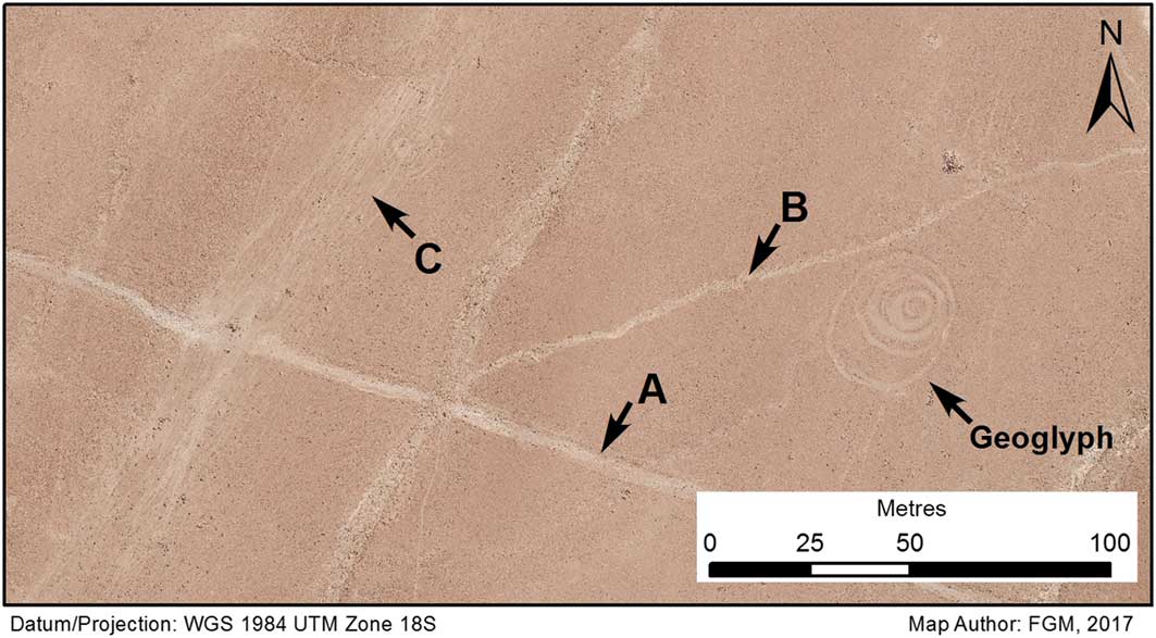
Figure 5 Maps showing examples of pre-Columbian and colonial road ways: A) primary; B) secondary; and C) colonial.

Figure 6 Map showing the locations of all ancient roads and circular geoglyphs.
The pathways, as with the geoglyphs, are difficult to date (Hassig Reference Hassig1991). Nonetheless, we suggest that many of them are pre-Columbian in origin, based on three considerations. First, ground reconnaissance has identified primary roads leading into the Sihuas Valley that also ran through Quilcapampa and other pre-Columbian sites (Jennings et al. Reference Jennings, Berquist, Spence-Morrow, Bikoulis, Gonzalez-Macqueen, Álvarez and Bautista2018); other researchers have noted relationships between ancient sites and pathways in neighbouring valleys (Cardona Rosas Reference Cardona Rosas2015). Second, Middle Horizon and Late Intermediate Period ceramic fragments, although sparse, have been found during ground reconnaissance along the edges of pathways; in most cases, these fragments come from storage vessels probably broken en route. Finally, colonial-era routes—littered with smashed ceramic vessels (botijas) that were introduced to carry wine after the Spanish conquest (see Rice Reference Rice2011)—cut across some of the pathways, suggesting their pre-Columbian origins.
Spatial connections between geoglyphs and pathways
Initial and impressionistic observation of our dataset suggested that the locations of geoglyphs and pathways were closely aligned. To test whether spatial proximity of circular geoglyphs to pathways was an important structuring feature of landscape use on the pampa, buffers of various distances were created around the identified roads (Figure 7). Previous analysis showed that the distribution of known geoglyphs was strongly spatially autocorrelated (Bikoulis et al. Reference Bikoulis, Gonzalez-MacQueen, Spence-Morrow, Alvarez, Bautista and Jennings2016: 121). As it is unclear, whether the mapped geoglyphs represent the original total, however, the normality of our sampling is uncertain. The locations of recorded geoglyphs were therefore compared using statistical bootstrapping methods (Monte Carlo, using 1000 iterations), which provide a method of approximating a normal distribution (Conolly & Lake Reference Conolly and Lake2004: 161–62). We used these ‘experimental distributions’ to test our observed geoglyph distributions to determine whether proximity to roadways was an important factor in the placement of geoglyphs (Fotheringham et al. Reference Fotheringham, Brunsdon and Charlton2000: 201–209).

Figure 7 Bar graph showing the cumulative frequency distribution of pre-Columbian and colonial geoglyphs at different buffering distances.
The statistical association between both colonial and pre-Columbian pathways to geoglyphs is highly significant (Table 1). As a very general yet powerful non-parametric test between two samples, the K-S Test was used as a ‘goodness of fit’ test to assess the difference between the expected (obtained from the Monte Carlo modelling) and observed site distributions. Results show that geoglyphs are located in very close association with pathways, in far greater frequency than would be expected if proximity to these features were not a factor. The connections of colonial paths to geoglyphs reflects the continued use of sierra-coastal routes that gained prominence in the Late Intermediate Period when—based on associated pottery—most of the circular geoglyphs were created (Jennings et al. Reference Jennings, Berquist, Spence-Morrow, Bikoulis, Gonzalez-Macqueen, Álvarez and Bautista2018). After the Spanish conquest, sierra populations became more isolated, with most of the wine and other coastal products flowing into Lima and other colonial centres (Buller Reference Buller2011). Yet mule caravans still linked highland and coastal valleys, and this traffic appears to have followed roughly the same paths across the pampa, until the mid twentieth-century expansion of vehicular road networks (Trawick Reference Trawick2003: 61–62).
Table 1 Results of Kolmogorov-Smirnoff (K-S) test between expected (Monte Carlo) and observed set geoglyphs, based on frequency within given buffering distance.

Discussion: created landscapes on the pampa
Bikoulis et al. (Reference Bikoulis, Gonzalez-MacQueen, Spence-Morrow, Alvarez, Bautista and Jennings2016: 126) demonstrated that geoglyphs cluster around locations where trails leave the Sihuas Valley; here we also found the highest concentrations of rock cairns, wind blocks, painted stone cobbles and ceramic scatters during our pedestrian survey (Jennings et al. Reference Jennings, Berquist, Spence-Morrow, Bikoulis, Gonzalez-Macqueen, Álvarez and Bautista2018). It appears that people spent more time in this ecotone than what would be suggested by its general lack of resources and other such purely utilitarian considerations. As the pathways across the Sihuas Valley linked together long-standing settlements, the circular geoglyphs associated with them were probably made en route by travellers walking between river valleys and settlements. The convergence of these features suggest long-term action as people moved through a landscape marked by the passage of others who had traversed the region long before.
The role of small-scale anthropogenic landscape features, such as the geoglyphs encountered on the Sihuas pampa, may be functionally analogous to apachetas—the stone piles left by travellers and known from across the Andes (Galdames Rosas et al. Reference Galdames Rosas, Choque Mariño and Díaz Araya2016). From the fifteenth century onwards, apachetas were the “miniature embodiments of Andean topography, designed to secure aid of the sacred landscape for a traveller’s journey” (Dean Reference Dean2006: 93). Inca apachetas were often piled stones that, together, mimicked the shape of nearby mountains that had come into view following a steep climb (Dean Reference Dean2006: 98; Christie Reference Christie2008). Contemporary herders and travellers propitiate a wide variety of natural and anthropogenic features on their journeys, taking a moment to rest and make an offering of a cobble, cigarette, alcohol, piece of cloth, coca or other items (Jett Reference Jett1994: 5; Nielsen Reference Nielsen2016: 234). The cresting of mountain passes and other inflection points in the landscape remain amongst the most spiritually charged moments on a traveller’s journey (Flores Ochoa Reference Flores Ochoa1979), just as they were for the Inca.
The large and elaborate geoglyphs that dominate the scholarly literature have been rarely linked with travel rituals. The Monkey, Hummingbird and other famous Nazca geoglyphs probably required significant time to plan and execute. There are examples of geoglyphs in Sihuas, such as the Gross-Munsa, that approach a comparable scale of investment. Most of the Sihuas geoglyphs, however, could have been produced easily in a few minutes by people removing the overlying sediment (e.g. Lambers Reference Lambers2006: 71). These more expedient geoglyphs tend to be found in locations where the region’s three snow-clad peaks would become visible to a traveller. They are often surrounded by small rock cairns, pottery smashes and painted cobbles that probably served ritual purposes. We therefore suggest that travellers created many of the circular geoglyphs in order to propitiate spiritual aid for their journey. As long-distance exchange increased in the Late Intermediate Period, so did the pace of ritual activity, creating much of the anthropogenic landscape that we see on the modern Sihuas pampa.
Conclusions
For the first time in the Andes, we present the results of a systematic survey that quantitatively demonstrates a spatial association between pre-Columbian pathways and geoglyphs. Using a combination of different data products collected from satellite imagery, low-altitude aerial survey and in-the-field reconnaissance, the Quilqapampa Geoglyph Survey project has documented and mapped over 100 geoglyphs in southern Peru, focusing in particular on circular examples. Geoglyphs served many purposes in the ancient Andes, some highlighting astronomical alignments, others serving as territorial markers or ritual pathways (Briones Reference Briones2006; Lambers Reference Lambers2006; Stanish et al. Reference Stanish, Tantaleán, Nigra and Griffin2014). Although the Sihuas geoglyphs also served a wide variety of purposes, our preliminary analysis suggested a clear association between many of the circular geoglyphs and ancient pathways. This initial observation is confirmed by the strong, statistically significant, spatial association between the two feature types. We therefore suggest that circular geoglyphs in Sihuas may have been created ‘on the go’ by people traversing the region, who sought the aid of various deities and cosmic forces along the way.
While the analyses reported here are encouraging, several areas for future development are clear. Further work surveying sections of road networks may uncover more datable material, which would necessarily alter both our temporal designation for pathways and their spatial relationships with geoglyphs. Additional analyses incorporating other types of geoglyphs may reveal different associations. Lastly, the present study does not include the location of other anthropogenic features, such as rock cairns, which are interspersed with geoglyphs across the landscape (see Figure 2). The incorporation of these additional features into further quantitative analyses may help to explain the strong association between geoglyphs and ancient roadways, and enable us to understand better these ubiquitous but previously neglected anthropogenic landscape features.


