


Introduction
The Epipalaeolithic period in Nubia and the Levant (c. 23000–11500 BP) encompasses a major turning point in human history. It is during this time that we see the first evidence for residential sedentism, and a shift from foraging to farming. Understanding the modus operandi of this transformation in food production remains a genuine challenge to archaeologists, and sites in north-eastern Africa and south-western Asia represent valuable sources of data with which to examine potential drivers of this important transition.
Affad 23 is a c. 16000-year-old site in the Middle Nile Valley of Sudan. It has yielded evidence of dwellings or shelters, well-defined activity zones including meat-processing areas, and a faunal assemblage confirming a specialised hunter-gatherer economy. Whether these structures and subsistence practices foreshadow the shift towards sedentism and an agricultural economy remains an open question, but the archaeology shows that the occupants of Affad 23 were not using conventional Epipalaeolithic stone tool technologies (e.g. microliths), but continued to exploit Levallois-like tools. This late use of Middle Palaeolithic technology, along with a highly organised camp configuration, points to an unusual adaptive strategy.
We present here the results of renewed investigations at Affad 23, building on an initial survey in 2003 (Osypiński et al. Reference Osypiński, Osypińska and Gautier2011). The new data suggest that occupation broadly correlates with the abrupt return of the African monsoon system c. 15 kya and the associated replenishment of the Nile from the overflowing of the Ugandan lakes.
The discovery of Affad 23
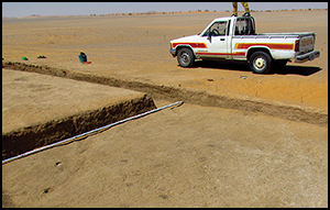
Archaeological research on a cluster of Terminal Pleistocene sites near the village of Affad in the Southern Dongola Reach (SDR) of Sudan (Figure 1) commenced in 2003 (Osypiński et al. Reference Osypiński, Osypińska and Gautier2011). This initial work yielded diagnostic assemblages of lithic artefacts and fossilised faunal remains primarily on the ground surface, the only stratified archaeology coming from a small (1m2) test pit. A new phase of survey coupled with full-scale excavation began in 2011. An approximately 10km2 survey around Affad (Figure 2) identified a total of 48 tool scatters with manufacture in the Levallois tradition, many of them marking occupation zones or areas used for hunting or scavenging activities.

Figure 1. Location of Affad 23. The lower image, looking south towards the modern Nile Valley, shows the site (indicated by the arrow and circle in aerial photograph) taken from the Nubian Sandstone plateau to the north (location of photograph shown by red dot). Aerial photograph courtesy of the Sudan Survey Department.

Figure 2. Topographic map of the central part of the Affad Basin with Terminal Pleistocene sites located, including Affad 23 at the centre of the image. The north-eastern trending ‘arm’ of the survey shows the transect of geological test pits used to reconstruct the palaeogeography of the site and its environs (drawn by P. Osypiński).
Excavations since 2012 (Figure 3) have revealed a series of small circular and sub-circular cut features within a spatially constrained area of about 25m2 (Trench 2012/B; Figure 4). Dense concentrations of fossilised faunal remains, dominated by kobus antelope, were recorded in the immediate vicinity of these features (Figure 4). Two further locations in which cut features were identified were also examined in 2013 and 2014. A large excavation area (450m2; known as 2013/F–I,Q; Figures 5 & 6) was opened up at the site of the 2003 test excavations (Figure 7), and another smaller one (150m2; known as 2013/M–L) approximately 35m to the south-east (Figure 8). These excavations confirmed that lithic artefacts and faunal remains were present not only on the surface, but also within secure stratigraphic contexts.

Figure 3. Plan of Affad 23 with marked excavated areas (clusters of cut features highlighted; drawn by P. Osypiński).

Figure 4. Plan of 2012/B trench with medium-sized antelope bone clusters, cut-features and combustion features indicated. Inset: concentration of articulated bones of kobus antelope (drawn by P. Osypiński, photograph by M. Osypińska).

Figure 5. Plan of Trench 2013/F–I,Q with lithic clusters, cut features and combustion features indicated. Contours relate to the upper surface of Unit 11.1, which broadly represents the topography of the site during occupation (drawn by P. Osypiński).

Figure 6. View of the north-west sector of Trench 2013/I with postholes in situ visible as dark fills against the yellowish-brown sands and silts of the alluvial and colluvial substrate. Inset: the laminated fills of one of the cut features (photographs by P. Osypiński).

Figure 7. Plan stratigraphy of the camp area at Affad 23 (50–100mm below present-day ground surface), indicating refitting links (after Osypiński et al. Reference Osypiński, Osypińska and Gautier2011: fig. 2). The black square marks the location of the 2003 test pit. Inset: key stratigraphic sequence of Affad 23 (Section 2013/H/10; GT11).

Figure 8. Plan of Trench 2013/L–M with animal bone clusters and cut features. Contours relate to the upper surface of Unit 11.1, which broadly represents the topography of the site during occupation (drawn by P. Osypiński).
Although stone-working sites have been recorded in the Middle Nile Valley (Marks et al. Reference Marks, Hays and De Heinzelin1968; Garcea Reference Garcea2003; Van Peer et al. Reference Van Peer, Fullagar, Stokes, Bailey, Moeyersons, Steenhoudt, Geerts, Vanderbeken, De Dapper and Geus2003; Masojć Reference Masojć2010; Wąs Reference Wąs2010), evidence for Palaeolithic settlement—providing data about the subsistence strategies adopted by groups exploiting this riverine environment—has yet to be identified. The story is no clearer outside the Nile Valley: north-eastern Africa has yielded only scant evidence of actual settlement prior to the Holocene (Vermeersch Reference Vermeersch2000; Banks et al. Reference Banks, Snortland, Cummings, Gatto and Usai2015). Only in the Levant region of south-western Asia do we see unequivocal evidence for settlement structures, such as Ohalo II in Israel (Nadel & Werker Reference Nadel and Werker1999) and Kharaneh IV in Jordan (Maher et al. Reference Maher, Richter, Stock, Macdonald, Jones and Martin2012), testifying to long-term (multi-seasonal) occupancy of constructed dwellings.
Late Quaternary evolution of the River Nile
The evolution of the Nile Valley in the Late Quaternary has attracted considerable research interest over the past several decades. Early work focused on identifying major aggradational and incisional events, and on linking these changes in river behaviour to broad-scale shifts in the north-eastern African climate (e.g. Wendorf et al. Reference Wendorf, Schild and Issawi1976; Adamson et al. Reference Adamson, Gasse, Street and Williams1980; Butzer Reference Butzer1980; Wendorf & Schild Reference Wendorf, Schild, Klees and Kuper1992). Recently, there has been a drive to generate high-resolution data, modelling the response of the river system to both long- and short-term climatic shifts, and in identifying the implications of these environmental changes for populations exploiting Nile Valley resources (e.g. Williams et al. Reference Williams, Adamson, Cock and McEvedy2000, Reference Williams, Williams, Duller, Munro, El Tom, Barrows, Macklin, Woodward, Talbot, Haberlah and Fluin2010, Reference Williams, Usai, Salvatori, Williams, Zerboni, Maritan and Linseele2015; Woodward et al. Reference Woodward, Macklin, Krom, Williams and Gupta2007; Williams Reference Williams2009; Vermeersch & Van Neer Reference Vermeersch and Van Neer2015). In the Terminal Pleistocene (Marine Isotope Stage 2), changes in river-system behaviour have been linked to climatic shifts around the onset of the arid Last Glacial Maximum (LGM; c. 18±3 kya), and during the abrupt switch to wetter conditions heralding the onset of the African Humid Period (c. 15 kya) (deMenocal et al. Reference deMenocal, Ortiz, Guilderson, Adkins, Sarnthein, Baker and Yarusinsky2000; Gasse Reference Gasse2000; Williams et al. Reference Williams, Talbot, Aharon, Salaam, Williams and Brendeland2006).
Williams and colleagues have shown that there was a phase of ‘very high’ energy flow at 30–25 kya in the main Nile Valley near Affad 23, bracketed by two phases of ‘high’ flow at 32 and 20.7 kya (Williams et al. Reference Williams, Williams, Duller, Munro, El Tom, Barrows, Macklin, Woodward, Talbot, Haberlah and Fluin2010: 1131). These correlate with wet phases (pluvials) identified in the African tropical hydrological record (Gasse Reference Gasse2000). Subsequently, arid conditions associated with the LGM are recorded in lowstands in Lakes Victoria and Albert in Uganda (Gasse Reference Gasse2000), because the White Nile outflow of water from these lakes was restricted, themselves fed by insolation-driven changes in African monsoon precipitation (deMenocal et al. Reference deMenocal, Ortiz, Guilderson, Adkins, Sarnthein, Baker and Yarusinsky2000).
A switch to humid conditions c. 15 kya is recorded in North African palaeohydrological (Gasse Reference Gasse2000), aeolian (deMenocal et al. Reference deMenocal, Ortiz, Guilderson, Adkins, Sarnthein, Baker and Yarusinsky2000) and Nile alluvial records (Williams et al. Reference Williams, Talbot, Aharon, Salaam, Williams and Brendeland2006; Williams Reference Williams2009). Rising water levels in Lake Victoria spilled over into Lake Albert from c. 16.25 kya, resulting in overflow to the While Nile some time prior to c. 15 kya, a chronology that Williams et al. claim is “entirely consistent with our inferred onset of high Nile floods in the Sudan” (2006: 2663). This abrupt return of the summer monsoon marked the beginning of a period of relative humidity in the Nile Valley, punctuated by short-lived phases of aridity, that lasted to around 5000 years ago (Woodward et al. Reference Woodward, Macklin, Krom, Williams and Gupta2007; Williams et al. Reference Williams, Williams, Duller, Munro, El Tom, Barrows, Macklin, Woodward, Talbot, Haberlah and Fluin2010).
Methods employed to reconstruct the Affad 23 settlement site
Artefactual material was precisely located in three dimensions using a Total Station. Archaeological cut features were recorded in plan and their stratigraphic relationships established relative to lithological layers, archaeological horizons and other cut features. Cut features were half-sectioned to record their profile and to describe fill type (Table 1; Figure 5).
Table 1. Structure of the lithic assemblage from Affad 23. Frequency of artefacts from the primary depositional context (Unit 11.3), and from lag deposit (number in brackets).

Identification of faunal elements to species level was undertaken using comparative bone collections of sub-Saharan fauna from the Royal Belgian Institute of Natural Sciences in Brussels and Palaeontology Research Unit, Ghent University, Belgium (Stuart & Stuart Reference Stuart and Stuart2006; Plug Reference Plug2014: 491–97).
Lithic technological traditions were assigned based on both typological methods and refittings. Raw material, morphology and dimensions of each artefact were recorded, as well as their position within the reconstructed chaîne opératoire. Refittings allowed the tracking of each worked nodule as it was dispersed, indicating the spatial relation between clusters of lithics and cut-features.
Geoarchaeological work was undertaken to provide information regarding the formation and preservation of the site, and to locate Affad 23 within the dynamics of the Quaternary landscape. To determine the nature of the buried topography, geological test pits (GTs) were excavated to record the sub-surface stratigraphy at the site and extract samples for OSL dating (Figure 2).
OSL samples were extracted from open sections in metal tubes, with both ends covered to avoid exposure to sunlight. OSL age estimates were undertaken in the Academic Laboratory Centre of the Institute of Geography, Jan Kochanowski University, Kielce, Poland. The OSL laboratory methodology and age estimates obtained can be found in the online supplementary material.
Placing Affad 23 in its cultural, environmental and temporal context
The largely level, present-day setting of Affad 23 is the result of sediment infilling of a relict topography associated with a range of former riverine environments, including wetlands and palaeochannels, recorded in both archaeological trenches and geological test pits (Figure 2). This area is bounded to the north by the relatively high-elevation Nubian Sandstone plateau, and to the south by the northern margins of the modern Nile floodplain (Figure 1).
Within this landscape, Affad 23 was located on an area of higher ground at the margins of a channel (or series of channels) adjacent to wetland environments. Evidence of these environments was observed in a number of geological test pits (GTs), including mottled, manganese-stained silts with frequent ferruginous root casts (GT1 & GT2), fluvial silts and fine sands (GT1, 3–5, 9 & 11), and channel sands (GT6) (Figure 2). Although fluvial geomorphic features were barely discernible at ground level or on satellite imagery, a geomorphological map published by Williams et al. (Reference Williams, Williams, Duller, Munro, El Tom, Barrows, Macklin, Woodward, Talbot, Haberlah and Fluin2010: 1120, fig. 3) indicates a linear feature very close (<20m) to Affad 23, originally surveyed and identified as a low-lying feature in the landscape around Affad in 2005 (N. Munro pers. comm.).
The archaeological material and cut features found at Affad 23 were recorded in association with interstratified alluvial and aeolian silts and sands, indicating changes in Nile river behaviour over a c. 6000-year period. Exposed at the base of the sequence in GT11 (Trench 2013/H/10), Unit 11.1 is a compact, calcareous silt, with an OSL age of 21.1±2.32 kya (UJK-OSL-36) (Figure 7). Given that the cold and arid conditions experienced in the Nile Valley during the LGM promoted increased aeolian dust flux and dune formation (Woodward et al. Reference Woodward, Macklin, Krom, Williams and Gupta2007; Williams et al. Reference Williams, Williams, Duller, Munro, El Tom, Barrows, Macklin, Woodward, Talbot, Haberlah and Fluin2010), infilling increasingly ephemeral flood channels, the well-sorted and homogeneous silts of Unit 11.1 may be windblown dust that has banked up and across the margins of a channel. In the Egyptian Nile Valley, Vermeersch and Van Neer (Reference Vermeersch and Van Neer2015) report damming of the river channels due to deposition of windblown sediment outpacing the scouring action of seasonal flood surges. Although the deepest parts of archaeological cut features penetrate the upper levels of 11.1, these features relate to archaeological activity recorded in sandy silt layers 11.2 and 11.3.
From c. 15kya, the climate ameliorated and the Nile experienced peak flows again, correlating with the abrupt return of the African monsoon system, increasing precipitation and runoff in the Ugandan and Ethiopian headwater regions: the onset of the African Humid Period (deMenocal et al. Reference deMenocal, Ortiz, Guilderson, Adkins, Sarnthein, Baker and Yarusinsky2000; Gasse Reference Gasse2000). An age of 15.9±1.75 kya (UJK-OSL-35) for Unit 11.3, a sandy unit from which much of the evidence for occupation was recovered, indicates the period during which Affad 23 was occupied by groups inhabiting the area. Around this time, the desiccated flood channels were re-activated, forming a multi-channel Nile river system for much of the year. This created and nourished adjacent wetlands, evidenced by manganese-stained silts and clays and frequent root casts observed in geological test pits (GT1 and GT2), corroborated by the presence of wetland-adapted fauna. The higher margins would have been a highly attractive area at the edge of this network of active channels and marshy low ground. In the White Nile, Williams et al. (Reference Williams, Usai, Salvatori, Williams, Zerboni, Maritan and Linseele2015) record gastropod shells recovered from alluvial clays, radiocarbon-dated to 15.4–14 cal kya, indicative of the increase in Nile flow at this time. Affad 23 was sufficiently elevated above the flooded valley for groups to construct camps of simple wooden structures. Such a staging post at the edge of the floodplain would have enabled short-distance forays into the resource-rich valley floor environment in search of wetland-adapted animals, such as the kobus antelope.
Alluvial silts recorded at the top of the sequence (11.4), and sealing some of the settlement features, dated to 15.30±1.68 kya (UJK-OSL-34), indicate that the site became flooded as the summer monsoon intensified and the channels regularly achieved peak flow. Evidence for human activity at this time drops sharply: Nilotic groups were perhaps forced out of the valley itself to exploit hinterland areas and higher ground.
This model of site formation, occupation and abandonment is somewhat at odds with a previous interpretation (Osypiński et al. Reference Osypiński, Osypińska and Gautier2011). We now know that the test pit explored in 2003 lay within the boundaries of a depression in the ancient topography. At this time, we assumed a straightforward and generally uniform stratigraphy across the entire site, and so when deeper artefacts (Level II, 2003) were identified within a sandy unit (part of Unit 11.3 within the ancient depression) and sealed within an archaeologically sterile silt (now known as 11.4), they were interpreted as evidence of an older occupation of the site. Since 2013, we have been able to confirm that Unit 11.3 is the only sedimentary unit related to Terminal Pleistocene settlement. The sediments exposed in plan in 2013 (Figure 7) include late-LGM silts (Unit 11.1); the sands on which settlement activities occurred (Unit 11.3); silt that seals depressions in the ancient topography (Unit 11.4); and Holocene lag deposits (gravels) containing redeposited ‘Khartoum Mesolithic’ archaeology (Osypiński et al. Reference Osypiński, Osypińska and Gautier2011).
The evidence for settlement: structures at Affad 23
Circular and sub-circular cut features, which we interpret as pits and postholes, were recorded within excavation areas 2012/B, 2013/F–I,Q and 2013/L–M. As mentioned above, in some locations, these features penetrated into the underlying silt units, but it is worth emphasising that they were cut from a level equivalent to Unit 11.3, representing the original ground surface on which settlement occurred. Where the ground surface gained elevation, 11.3 was sometimes truncated, and only the basal part of the fills of these features remained within the underlying silts (11.2, 11.1).
Cut features revealed in Trench 2012/B (Figure 4) were often recorded only in the upper part of 11.1 owing to the difficulty of discerning these features in plan within the relatively loose and friable archaeology-bearing sands of underlying Unit 11.3. Most of the features were small (<150mm in diameter) with a rounded base (Type IV). Two slightly larger (>200mm) features (Type V), and two with flat bases (Type II), were also recorded. The fills were generally homogeneous, compact and pale. Two small Type I features contained fills with two distinct layers: a lower layer comprising laminated dark brown silts, and an upper layer consisting of loose sands. Since only the lower truncated parts of these features were preserved, it is difficult to determine their function, although it is still possible to assess their patterning; for example, features B/2–B/5 exhibit a sub-linear arrangement approximately 2m in length, oriented broadly east–west.
The greatest numbers of settlement features were recorded in excavation area 2013/F–I,Q (Figure 5 & 6), and most of these were in the upper part of 11.1, which formed an undulating surface with a marked depression in the western part of the excavation area. Only three features were recorded in Unit 11.3 directly, owing to difficulties observing them in plan due to the loose and friable sediment into which they were cut.
Variations in fill type and stratigraphy probably relate to the speed of infilling. Multi-layered and dual-layered fills may be the result of water pooling in the depression and causing fine laminations, or due to windblown sand resulting in layering. This may provide an indication of how long the holes were left open to the sub-aerial environment after falling into disuse. Homogeneous, single fills indicate rapid burial beneath either alluvium or dune sand, or deliberate infilling following the removal of a stake or pole. All of the cut features recorded were situated in a belt approximately 10m wide, oriented NE–SW, running approximately through the centre of the excavation area.
Small cut features associated with clusters of faunal material were recorded in area 2013/L–M (Figure 8). These features were all recorded in Unit 11.3. Three of the four features were small, and the only Type II feature had a relatively small diameter (180mm), possibly justifying re-assignment to Type I status. These features were all flat-bottomed except for one with a convex base (Type IV). They were filled with homogeneous, light-coloured fills, similar to features from 2012/B.
The near-total absence of artefacts within the fills of cut features at Affad 23 is worth noting. Exceptions were two Levallois waste flakes in the fill of a probable pit H/23, and single pieces of similar debitage in three potential posthole fills I/25, I/35 and Q/5 (Figure 9a–e).

Figure 9. a–e) Lithics from the fills of cut features; f & g) representative examples of typical epi-Levallois tools found at Affad 23 (drawn by P. Osypiński).
The stone tool and faunal assemblages from Affad 23
The excavated features at the site yielded highly distinctive stone tool and faunal assemblages. Analysis of the lithic assemblages (Table 1) reveals that raw material was procured from the riverbed and pre-formed using the Levallois reduction strategy (Boëda Reference Boëda, Dibble and Bar-Yosef1995). Artefact refittings indicate specific spatio-functional zones within the camp at Affad 23. The testing of raw material (stone) quality and primary core-flaking steps appear to have been carried out opportunistically across the entire area, whereas the processing of blanks (i.e. completing the reduction sequence) and production of retouched tools took place in specific localised zones, 3–8m2 in size (marked as ‘lithic clusters’ in Figure 5). These zones do not overlap cut features or hearths directly, suggesting that specialised stone-working took place in specific areas demarcated from other activity zones. Given that significant parts of the chaîne opératoire are absent at Affad 23 (e.g. Levallois point production—one of the most typical tool forms), it is plausible that we are seeing evidence for a mobile settlement strategy, which is supported by the faunal assemblage.
A very well-preserved and environmentally diagnostic faunal assemblage is dominated by wetland-adapted species preferring perennial water-availability, good bush-coverage, and low trees and shrubs. Animals identified include several species of Bovidae including kobus antelope, bohor reedbuck, oribi, dik-dik and African buffalo (Table 2). Remains of hippopotamus and vervet monkey are also numerous, along with several bones of the greater cane rat and Varanidae. These observations fit well with the reconstruction of the valley floor environment at this time, with marshland present around the site from the beginning of the African Humid Period—when Nile flow was much higher than in the preceding LGM period—but before major periods of channel incision.
Table 2. List of identified species from Affad 23 (up to 2014).

Preliminary analyses suggest that Affad 23 was a camp used during seasonal low-water levels, and the distribution of some associated skeletal elements indicates localised meat-processing areas at Affad 23. The notable absence of fish, except for a single bone, lends support to Van Neer's (Reference Van Neer2004) hypothesis that late Pleistocene populations fished only in floodplain pools at the beginning or end of the high-water season. Furthermore, the absence of immature animal remains and a dominance of medium-sized antelopes might relate to dry season behaviours, when herbivorous animals tend to gather in large herds around remaining waterholes. If we were able to prove the existence of similar camps at the same elevation in the region, it might indicate a rotating settlement pattern linked to seasonal fluctuations in river level.
Affad 23 in its dynamic valley floor environment
Archaeological and palaeoenvironmental data suggest that Affad 23 was a temporary settlement with light structures, situated at the edge of a valley floor environment susceptible to both short-term (seasonal) and long-term (climate-driven) inundation by rising river levels. At the time of occupancy, 15.90±1.75 kya, the site was located on an area of high ground adjacent to active flood channels and wetland environments.
The abrupt return of the summer monsoon c. 15 kya caused river levels to peak, ultimately leading to site abandonment. In the final phases of the Pleistocene and early Holocene, the Nile adopted its present-day single channel morphology to the south of the site, and the low-lying area to the north of Affad 23 gradually infilled with alluvial, aeolian and colluvial sediments. Similar processes of channel abandonment coinciding with changes in settlement strategy are commonly reported in climatically marginal areas such as North Africa, the Arabian Peninsula and the Indus Valley (e.g. Staubwasser et al. Reference Staubwasser, Sirocko, Grootes and Segl2003; Giosan et al. Reference Giosan, Clift, Macklin, Fuller, Constantinescu, Durcan and Syvitski2012; Macklin et al. Reference Macklin, Woodward, Welsby, Duller, Williams and Williams2013).
The faunal assemblage at Affad 23 suggests that the valley floor environment was shrouded with a low vegetation of grasses, herbs and wetland flora. This multi-channel floodplain would have formed a much wider riparian corridor than the single-channel floodplain that we see today, providing sufficient wetland habitat to sustain a variety of floodplain-adapted animal species. The occupants of the site exploited a wide range of riverine resources, including chert river cobbles for stone tool manufacture, medium-sized ruminants for food, and various elements of the local flora for food, fuel and construction material. This picture accords well with adaptation strategies that have previously been proposed for Terminal Pleistocene Nilotic cultures (Wendorf & Schild Reference Wendorf, Schild, Klees and Kuper1992; Vermeersch et al. Reference Vermeersch, Van Neer, Gullentops, Kroeper, Chłodnicki and Kobusiewicz2006), in contrast to models of early Holocene dependence on fishing and gathering (molluscs are notably absent in the Affad collections). Unlike Lower Nubian cultures (e.g. Sebilian, Gemaian and Halfan) that exploited flake-oriented reduction strategies (Schild & Wendorf 2010), the technology at Affad 23 does not include recent innovations in stone tool production such as microliths or composite tools using backed implements.
The archaeology from trench 2012/B provides compelling evidence for the contemporaneous association of a series of small cut features (Table 3) and the articulated limb bones of a kobus antelope (Figure 4). The limb must have been buried rapidly as it would otherwise have been scavenged and the skeletal elements scattered. These articulated bones are indicative of carcass processing, including skinning and filleting to remove choice portions of meat from the bone. Other aspects of the processing might have required the use of ancillary equipment, such as frames for stretching hides or drying meat. This would be supported by the Affad stone tool repertoire, with a dominance of denticulated tools (45 per cent of all retouched Terminal Pleistocene forms at the campsite (Trench 2013/F–I,Q), and 75 per cent at the meat-processing area (Trench 2013/M–L); Table 1, Figure 9f & g) and a lack of heavy implements with which to chop larger bones. We suggest that the sub-circular cut features in excavation area 2012/B, and those in 2013/L–M between the concentrations of animal remains, should be interpreted as postholes for food-processing structures.
Table 3. Types of cut feature from Affad 23.

The cluster of features in area 2013/F–I,Q is situated between zones of intense stone tool manufacture. We believe that this area was the main settlement focus, where numerous light wooden structures for shade from the sun and/or wind were installed. The larger features have a rather different purpose to those that are smaller. The former are unlikely to be sunken hearths or fire-pits, such as those known from Arkin 5 or Sodmein Cave (Chmielewski Reference Chmielewski and Wendorf1968; Van Peer et al. Reference Van Peer, Vermeersch, Moeyersons, Van Neer, Pwiti and Soper1996; Van Peer & Vermeersch Reference Van Peer, Vermeersch, Mellars, Boyle, Bar-Yosef and Stringer2007), as no burnt material was associated with them. Although their function remains equivocal at present, there is a wealth of data indicating the use of pits for storage at Epipalaeolithic settlement sites such as Wadi Kubbaniya site KH26 in Middle Egypt, dated to the sixteenth millennium BP (Banks et al. Reference Banks, Snortland, Cummings, Gatto and Usai2015). At Affad, however, their use as storage pits seems unlikely given their secondary fills of clean and homogeneous windblown sand or silt laminations, suggesting the natural infilling of open hollows.
At Affad, Palaeolithic combustion features were recorded in the form of localised patches of baked sediment. These features did not penetrate deeply into the ground, and these possible hearths are not, therefore, evidence of repeated or intensive use of fire. Hearths may have been used as sources of smoke in the context of the possible hide- or meat-processing structures, either to reduce the number of flies in the area, to cure the meat, or both.
The lithic technology employed by the occupants of Affad 23 should be termed epi-Levalloisian, sensu stricto Arkell (Reference Arkell1949). The scarcity of research on Terminal Pleistocene sites in the area south of Lower Nubia emphasises the importance of Affad for understanding the prolonged use of technological traditions that may have been superseded elsewhere. As we have seen, the continued use of this older lithic tradition by the occupants of Affad some 16000 years ago was in sharp contrast to the evolution of blade manufacture recorded in Upper Egypt, including Taramsan (Van Peer et al. Reference Van Peer, Vermeersch and Paulissen2010) and the pan-Saharan blade tradition at Fakhurian, Idfuan, Afian, Isnan and Kubbaniya (Schild & Wendorf 2010). It is likely that technological innovations resulted from demographic and social factors, as well as shifts in the environmental conditions of Upper Egypt (Schild & Wendorf Reference Schild, Wendorf and Friedman2002). Affad 23, 500km to the south, appears to have been outside this sphere of influence, potentially highlighting a more stable environment in the south than that in Upper Egypt and the Levant.
Conclusion
Excavations at Affad 23 have produced numerous archaeological features that we interpret as postholes, pits and hearths: evidence consistent with a settlement site—most likely a seasonally occupied campsite complete with specific spatially segregated activity zones. Occupation of the site broadly coincides with the onset of the African Humid Period (c. 15000 BP). The faunal assemblage at the site is exceptionally discriminative, providing an excellent palaeoenvironmental framework from which to reconstruct the valley floor landscape around the site, as well as affording valuable insight into the subsistence strategies adopted by its occupants.
Our results shed new light on construction techniques, on the size and function of the settlement, and on the subsistence strategies used in the Terminal Pleistocene. Periodically waterlogged, the depositional environment led to the preservation of evidence of daily life on a Late Pleistocene site that is usually too ephemeral to survive. The built structures are likely to have been used both as shelters from the sun and wind, and as frames associated with the processing of hides and meat.
Affad 23 may not offer evidence of a broadly reduced mobility per se, but rather the adoption of a food-production strategy whereby mobile (temporary) food-procuring and -processing camps were situated adjacent to well-stocked hunting grounds. Whereas some Epipalaeolithic sites in the Levant and immediately adjacent areas show evidence of residential sedentism—or at least dwellings that were significant enough to suggest long-term occupation—the site of Affad 23 appears to have been occupied by mobile hunter-gatherers who recognised the benefit of investment in infrastructure and a punctuated mobility strategy in order to exploit fully a natural resource for subsistence purposes. The mechanism driving this process is unclear, especially given that we do not know where and when this practice started. It is possible that changes in Nile behaviour caused by the overspilling of the Ugandan lakes drove a final expansion of groups such as this, who were still using subsistence strategies rooted in the Middle Stone Age but were equipped with the skills to construct camps comprising significant structures and specialised activity zones.
Acknowledgements
The project was financed exclusively by the National Science Centre (‘Levallois Tradition Epigones in the Middle Nile Valley’ UMO-2011/01/D/HS3/04125). The authors would like to thank the Sudanese field workers, Huyam Khalid and the Sudanese National Corporation for Antiquities and Museums. MM thanks Neil Munro for his useful comments on previous survey work in the region. This manuscript was greatly improved by two anonymous reviewers.


