Introduction
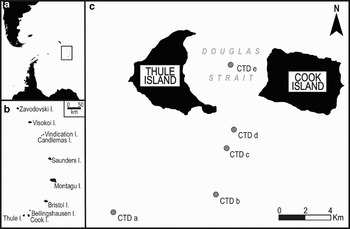
The Southern Thule island group (59.42°S, 27.23°W), comprising Thule, Cook and Bellingshausen islands is the southernmost cluster of islands in the South Sandwich Islands, an active intra-oceanic volcanic arc in the south Atlantic that forms the easternmost boundary of the Scotia Sea (Fig. 1). The South Sandwich Islands are the summits of several very large submerged volcanoes forming along the active edge of one of the Earth's smallest and fastest-moving tectonic plates - the South Sandwich Plate. The islands are all young, with an unconfirmed oldest age of 3 Ma (Baker et al. Reference Baker, Buckley and Rex1977) and each has been constructed from bathyal depths exceeding 2500 m to subaerial summits ranging between 200 and 1500 m above sea level (a.s.l.; Holdgate & Baker Reference Holdgate and Baker1979). Since their discovery in 1775, eruptions have been observed on most of the islands (Baker Reference Baker1990, Siebert & Simkin Reference Siebert and Simkin2002). The islands are remote, situated about 2000 km south-east of the Falkland Islands and a similar distance north of the Antarctic continent. They are also affected by a hostile weather regime, are poorly accessible by boat and are consequently visited only rarely. Contemporaneous observations are therefore very uncommon and are often only by satellite monitoring (Lachlan-Cope et al. Reference Lachlan-Cope, Smellie and Ladkin2001, Patrick et al. Reference Patrick, Smellie, Harris, Wright, Dean, Izbekov, Garbeil and Pilger2005). The islands are possibly the best example of a relatively primitive intra-oceanic island arc, one whose magmas formed through westward subduction of south Atlantic and Antarctic oceanic crust beneath the Scotia Sea plate (Barker Reference Barker and Taylor1995, Pearce et al. Reference Pearce, Baker, Harvey and Luff1995, Leat et al. Reference Leat, Smellie, Millar, Larter, Larter and Leat2003). Moreover, one of the islands (Montagu Island) has been in continuous eruption since late 2001, resulting in the construction of a growing area of new land (Patrick et al. Reference Patrick, Smellie, Harris, Wright, Dean, Izbekov, Garbeil and Pilger2005, Patrick & Smellie unpublished).

Fig. 1. Maps showing a. the location of the South Sandwich Islands within the South Atlantic, b. the South Sandwich Islands arc, and c. Thule and Cook islands with the positions of the CTD stations marked.
Although it has recently become possible to monitor volcanic activity remotely from satellite-derived radiometry (e.g. MODIS - Moderate Resolution Imaging Spectroradiometer, geological and geophysical observations provide the highest-resolution characterization of changes in the island group, and the best way of assessing the nature of past eruptions and the risks and hazards associated with an active oceanic island arc.
This paper summarizes several new volcano-tectonic observations of a small but important part of the South Sandwich Island group. Southern Thule, comprising three islands, two of which are largely snow- and ice-covered, contains several not yet described volcano-tectonic features that are probably representative of the volcanic geology of the entire volcanic island chain. In addition, we present the first multibeam (swath) bathymetry data of Douglas Strait, which contains the only confirmed submarine caldera in the South Sandwich arc, and results of a reconnaissance hydrological transect from the region.
Geological and oceanographical background
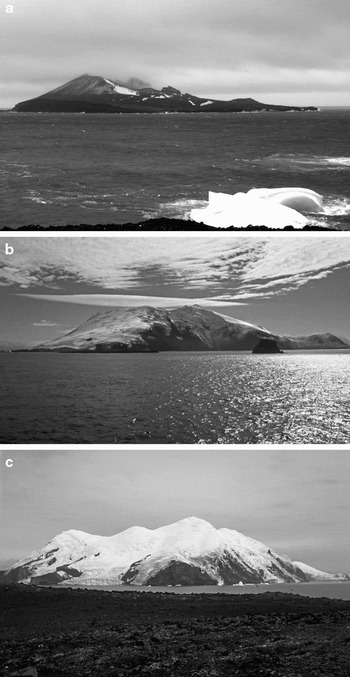
Thule, Cook and Bellingshausen islands are each separate volcanic centres constructed on the broad wave-cut summit of a single very large submerged volcano measuring about 30 km in basal diameter (Fig. 2a, b & c). Cook Island is the largest island, measuring about 6 km in length and rising to 1075 m a.s.l. It is roughly rectangular in outline, with several largely inaccessible fringing rock cliffs and bluffs and which culminates upward in several cone-shaped peaks (including Mount Harmer and Mount Holdgate) (Fig. 2c). Thule Island is also about 6 km in length but is triangular in outline and rises to just 725 m a.s.l. (Fig. 2b). It is dominated by the prominent stratocone of Mount Larsen. In addition to numerous inaccessible rocky coastal cliffs, two low-lying headlands are present at Beach Point and Hewison Point. Bellingshausen Island is considerably smaller and younger than the other two islands, measuring just 1.5 km in length and rising to only 253 m a.s.l. (at Basilisk Peak) (Fig. 2a). It is dominated by a broad perpetually steaming crater measuring about 500 m in diameter. Both Cook and Thule islands are largely covered in snow and ice whereas Bellingshausen Island is almost ice free. Eruptions have only been documented for Thule Island where, in March 1962, a steaming crater about 150 m across had opened up in the thickly ice-covered summit region west of Mount Larsen and ash was observed on the snow-covered south-west slopes of the island (Holdgate Reference Holdgate1963).

Fig. 2. Views of islands forming Southern Thule. a. Bellingshausen Island, viewed looking north. The island is small, largely ice free and dominated by a large steaming crater, and it is in a very young stage of formation. b. Thule Island, viewed looking north-west. The island is a well-formed symmetrical snow-clad stratocone with a prominent summit caldera in which a small eruption took place probably in 1961 or early in 1962 (Photo by R. Larter). c. Cook Island, the largest and probably oldest island in Southern Thule, viewed looking south-west. The island is heavily dissected around its coasts but several steep-sided snow-clad cones that were probably formed during spatter eruptions dominate the skyline. There is no evidence for a caldera or recent volcanic activity.
In consideration of the morphology of the two main islands, in particular the embayed cuspate eastern margin of Thule Island, which faces a similar but less pronounced embayed western margin on Cook Island, and a few reconnaissance hydrographic measurements, Baker (Reference Baker1990) proposed that the two islands were the subaerial remains of a single edifice that had possibly undergone caldera collapse in Douglas Strait. The presence of a marine caldera was confirmed by Smellie et al. (Reference Smellie, Morris, Leat, Turner and Houghton1998) using bathymetric, seismic and magnetometer data acquired in 1997. The bathymetrical data also revealed a shallower seafloor slope on the western interior of the basin, which was interpreted as evidence of a sediment mound derived from one or more landslips from the scarred cliff of eastern Thule Island (Smellie et al. Reference Smellie, Morris, Leat, Turner and Houghton1998).
Oceanographically, Southern Thule lies within the main belt of the Antarctic Circumpolar Current (ACC), the largest current system in the world (Klinck & Nowland Reference Klinck and Nowland2001) (Fig. 3). The ACC carries a core of Circumpolar Deep Water (CCPW) between 200 m and 4000 m that dominates the waters surrounding the Southern Thule but is too deep to influence the waters within Douglas Strait. The geometry of the Douglas Strait basin isolates all but the shallowest waters from exchange with the surrounding ocean. The hydrology of Douglas Strait is dominated by the seasonal variability of Antarctic Surface Water (AASW) and the impact of sea ice formation and melting. Southern Thule lies close to the average winter sea ice extent and experiences up to three months of sea ice cover each year.

Fig. 3. Map of the Scotia Sea region showing the regional bathymetry, the average position of the Polar Front (black dotted line), the seasonal sea ice limits (dark grey dotted and dashed lines) and the main routes of the Antarctic Circumpolar Current (solid grey lines).
Methods
Swath bathymetry
Detailed bathymetric data were acquired using an ‘EM120’ multi-beam echo sounder (swath bathymetry) system aboard RRS James Clark Ross during March 2006. The EM120 system sends a synchronous ping with up to 191 beams in an arc and calculates the distance covered by each beam of the ping, thus progressively building up a 3-dimensional image of the sea floor topography. The system was operated continuously and was regularly calibrated using sound velocity profiles derived from either CTD (conductivity, temperature, depth) casts or XBT (expendable bathythermograph) data. Sound velocities for the Douglas Strait swath data were calibrated using the temperature profile from a single CTD cast in the deep central basin (see Fig. 1 for location of CTD cast). Following acquisition and processing, the data were transferred to ArcGIS™ to facilitate mapping and to utilise the analytical tools available.
Hydrology
Five CTD profiles were measured using a SBE 911plus system (SEABIRD); one was situated in the deep central basin within Douglas Strait and four form a transect orientated away from the Thule and Cook islands (Fig. 1). These data provide a unique record of water mass properties and water column structure within the island group.
Results and discussion
New observations of volcanic activity and other volcanic features on the islands in Southern Thule
Observations obtained from a helicopter overflight in January 1997 determined that the flat summit region of Thule Island is a small ice-filled caldera about 1.7 km in diameter (Smellie et al. Reference Smellie, Morris, Leat, Turner and Houghton1998). A shallow dimple almost 500 m in diameter was evident in the snow near its centre on the northern side, at the approximate location of the 1962 crater. The dimple is also clearly shown in an ASTER image taken in September 2005 (Patrick & Smellie unpublished) indicating that it is a persistent feature. Similar pits are common and conspicuous on the surfaces of ice sheets overlying volcano-related geothermal sources, including within calderas (e.g. Gudmundsson et al. Reference Gudmundsson, Högnadóttir, Kristinsson and Gudbjörnsson2007), and, although the 1962 crater itself no longer exists, the presence of the dimple in the Thule Island caldera strongly suggests that volcanothermal heating has probably been persistent since the crater was originally formed. From its diameter, the potential for abundant meltwater production is high. Satellite observations also suggest that, in addition to a flank collapse into Douglas Strait postulated by Smellie et al. (Reference Smellie, Morris, Leat, Turner and Houghton1998), another similar sized and similarly undated major flank collapse might have taken place on the north-west side of the island, possibly in response to wave-related undercutting and erosion.
On Bellingshausen Island, observations in January 1997 indicated that several small east–west aligned explosion pits had formed on the south outer flank of the main crater since geological observations in 1964 (Holdgate & Baker Reference Holdgate and Baker1979, Baker Reference Baker1990). The main crater and cliffs on the east coast continue to steam weakly, with temperatures up to 101.7°C and sulphur encrustations on the crater floor. By contrast to the other two islands, there is no evidence for recent volcanic activity on Cook Island.
The three islands show very different morphologies. Bellingshausen Island is a very young island dominated by a prominent wide crater and the recent short-lived explosive activity is possibly distributed along a shallow east–west-aligned fissure. It is a new island in the earliest stages of its formation, and probably one of the youngest in the South Sandwich Islands. The symmetrical snow covered stratocone of Thule Island has an almost perfectly circular summit caldera and evidence of post-caldera resurgence (1962 crater). On the other hand, Cook Island appears now to be totally dead and its summit region comprises several steep-sided snow covered cones that are probably subaerial spatter cones. There is no evidence that a caldera has existed on that island, or else any caldera is completely infilled and obscured by post-caldera volcanic products.
Swath bathymetry
The high-resolution multibeam echo-sounder (swath bathymetry) image of Douglas Strait is presented in Fig. 4a. The image has a high level of bathymetric detail and the potential to resolve features hitherto unseen and therefore undescribed. As projected, the bathymetric image is orientated with west at the top of the image (i.e. looking from Cook toward Thule Island). It clearly shows a basin with steep margins surrounding a relatively featureless gently east-dipping to sub-horizontal sea floor at c. 620 m depth and a less steep flank at the top of the image (immediately below Thule Island). The new swath data confirm, and considerably improve, the crude reconnaissance geometry of the caldera described by Smellie et al. (Reference Smellie, Morris, Leat, Turner and Houghton1998). They further resolve variations in the meso-scale surface topography (1–100s of metres) of the sediment mound that rises westward and appears to be banked against the wall of Thule Island (Fig. 4b). The morphology of the outcrop suggests that it is a substantial hummocky debris pile, with numerous scattered surficial blocks and small hummocks. The fan-like outcrop covers much of the western half of the basin (Fig. 4b - black lines) and its morphology and surface features resemble those of debris fans, in particular the “blocky intermediate reach (often starting at the foot of headwall scarps) and a distal section of smaller blocks and a finer matrix” (Canals et al. Reference Canals, Lastras, Urgeles, Casamor, Mienert, Cattaneo, De Batist, Haflidason, Imbo, Laberg, Locat, Long, Longva, Masson, Sultan, Trincardi and Bryn2004). Like Smellie et al. (Reference Smellie, Morris, Leat, Turner and Houghton1998), we suggest that it is a sediment fan formed as a result of one or more collapses of the overlying flank of eastern Thule Island.

Fig. 4. Multibeam bathymetry data plotted in 3-dimensional view showing in a. an un-annotated ‘swath’ image of the Douglas Strait submarine caldera. In b. the likely debris fan is outlined by black dashed lines & arrows, and several small cone- or mound-like structures are marked with white solid lines and white arrows. A white dotted line is used to indicate the fresh-looking arcuate fault (possibly a very young nested caldera margin). In c. we have demarcated the minimum area of the debris fan used to calculate a minimum volume of the debris fan. All of the images are orientated along an approximately E–W axis, as if looking from Cook Island towards Thule Island.
We used spatial analyst tools in ArcGIS™ to define the area of the debris mound (Fig. 4c) and to calculate the minimum volume of sediment that it contains. We apply conservative boundaries to ensure a minimum volumetric measurement assuming that: a) the sediment mound lies directly upon the caldera floor, b) the caldera floor is flat and horizontal beneath the sediment mound, and c) the fault line of the nested caldera cross-cuts the sediment mound along the back wall of the debris slump. The calculations suggest that the minimum volume of sediment deposited into the caldera is c. 1000 m3 (Fig. 4c).
The inner surface of the steep caldera walls also shows a previously undescribed, conspicuous arcuate step-like feature between 300 and 500 m that can be traced continuously around half of the caldera walls (Fig. 4b - white dotted line). The feature is well defined, fresh looking and fault-like and is probably quite young. It appears to cross-cut and displace the basinal sediment mound at its apex. Although it cannot yet be validated, we suggest that the feature may be an arcuate fault related to a very recent younger phase of caldera collapse. Thus, the Douglas Strait caldera may be nested, i.e. a caldera forming within or overlapping an older caldera. In addition, three cone- or mound-like structures are present within the caldera, two on the sediment fan and one beyond the fan on the caldera floor (Fig. 4b - white solid lines marked with arrows). They occur at depths of c. 300–600 m. Even basaltic volcanic activity may be explosive at those relatively shallow depths (Kokelaar Reference Kokelaar1986) and the structures might be tephra cones or mounds formed of pillow lava. The basal diameter of the cone structures exceeds 100 m and makes them too large for purely fumarolic accumulations.
Hydrology
The CTD profiles of temperature and salinity are used to identify different water masses and record the structure and stability of the water column in and outside of Douglas Strait (see Fig. 1 for loction of CTD sites). The profiles from the outer slope all indicate a similar water column structure (Fig. 5a–d). In each, the waters below ~250 m are fairly homogenous becoming slightly cooler with depth. The surface waters are mostly homogenous to a depth of ~60 m, comprising a ‘surface mixed layer’ of relatively fresh, warm water (33.5 psu; ~0.0°C). Between ~60 m and ~250 m the waters are characterized by a thermal minimum (-1.0°C to -1.4°C) and a transitional horizon of increasing temperature and salinity that grades into the uniform waters below. The only changes evident along the transect outside the caldera is a strengthening pycnocline and a slight cooling and thickening of the thermal minima layer with distance offshore. The water mass properties recorded in the CTD profiles from the outer slope indicate a water column comprising Circumpolar Deep Water (CPDW) and Antarctic Surface Waters (AASW). Thus, below 250 m the temperature and salinity values fall well within the documented range for CPDW (0.0–0.8°C; 34.6–34.7 psu), whilst above 250 m the waters are typical of AASW with temperature and salinity characteristics derived from seasonal heating and cooling, and the advance and retreat of sea ice (Tomczak & Godfrey Reference Tomczak and Godfrey1994). The sub-surface temperature minimum reflects relict winter water, whilst the surface water preserves a meltwater signal and summer surface warming.

Fig. 5. CTD profiles showing temperature and salinity data for four stations established along a transect extending from the southern outer slope of Southern Thule (a.–d.) into the Douglas Strait caldera (e.).
Although the Douglas Strait caldera connects with the open ocean via two sills on its north and south flanks, they are very shallow (i.e. less than 30 m deep) and isolate the caldera from all but the shallowest waters. Moreover, the CTD cast from the deepest part of the caldera basin exhibits a markedly different water column structure to those acquired on the outer slope (Fig. 5e). The Douglas Strait water column has very cold waters (~-1.6°C, ~34.2 psu) below ~300 m, overlain by relatively warmer, fresher waters (~0.0°C, ~33.6 psu). However, the bottom waters are both more saline and cooler (~ -1.4°C,~34.2 psu) inside the caldera indicating that the basin has remained isolated from the warming influence of CPDW. In isolated basins, such as this caldera basin, convective cooling beneath sea ice will cool the entire water column. After summer melt-out, re-circulation may occur but only in the surface layer where wind and wave driven turbulence promote local circulation and shallow mixing, whilst the bottom waters are unaffected.
The presence of lower salinity and slightly warmer surface water in the caldera and off-shore is typical of a meltwater lens. Intriguingly, the base of the surface layer at localities outside the caldera is only slightly deeper than the shallow sill depth and offers the possibility that the meltwater originated primarily from within Douglas Strait, via the sills. Although the usual source of surface meltwater lenses in the Southern Ocean is sea ice, the sea around Southern Thule was free of ice by 24 December 2005 (Kaleschke 2007 at http://iup.physik.uni-bremen.de:8084/) and it is most unlikely that meltwater stratification derived from sea ice melting would be maintained until March 2006, when our survey was conducted. Other potential local sources of meltwater include glacier ice and snow on Thule and Cook islands and any grounded icebergs around the coastline. Given the duration of sea ice-free conditions we propose that melting of local ice and/or snow on the islands provide the primary source of meltwater around Southern Thule. This is further supported by Dierrsen et al. (Reference Dierssen, Smith and Vernet2002) who demonstrated that typical sea ice melt (derived from sea ice ~1 m thick) would reduce salinity by a maximum of ~0.5 psu. In their study, Diersson et al. (Reference Dierssen, Smith and Vernet2002) could not account for the > 0.8 psu freshening they recorded across the western Antarctic Peninsula shelf during late summer and they invoked a high influx of glacial meltwater to explain the discrepancy in density. The surface water salinities around Southern Thule also exceed the 0.5 freshening associated with sea ice melt and support a predominantly glacial source for the meltwater.
During the summer of 1982–1983 Perssinotto et al. (Reference Perissinotto, Laubscher and McQuaid1992) documented a similar meltwater lens, typically only 20–40 m, spreading offshore from islands in the South Sandwich chain that they attributed to run-off of seasonal snow and ice melt. The 2006 meltwater layer is approximately twice the thickness of the 1983 melt lens and may reflect a dramatic increase in meltwater run-off from the islands, potentially much larger than seasonal variability alone could explain. It is possible that glacier run-off in Southern Thule reflects a similar trend to the Antarctic Peninsula where recent regional warming is accelerating melt rates and causing widespread glacier retreat (Pritchard & Vaughan Reference Pritchard and Vaughan2007). Another plausible meltwater source on Southern Thule is the long-lived volcano-related melting at the base of the ice in the Thule Island caldera, since such melting can create large volumes of meltwater over time (e.g. Gudmundsson et al. Reference Gudmundsson, Högnadóttir, Kristinsson and Gudbjörnsson2007). Determining the relative importance and effectiveness of geothermal and/or atmospheric warming as a source of glacial melt on Thule Island is not possible without better meteorological, glaciological and geological constraints.
Although this paper only focuses on a small area of the South Sandwich volcanic arc, it highlights the inherently dynamic geological and hydrological setting of Southern Thule and demonstrates the need for a better appreciation and understanding of the volcanic, glaciological and geological context of these evolving and remote island outcrops.
Summary
This paper provides an updated view on the recent volcanic history and hydrological conditions of Southern Thule in the South Sandwich Islands. We present new observations of volcanic features on the islands themselves, two of which, at least, are active volcanoes, together with the first high-resolution bathymetric image of the Douglas Strait caldera. The latter is the only validated submarine caldera in the South Sandwich arc. The three islands are at different stages of evolution. The smallest, Bellingshausen Island, is small, snow free and dominated by a broad steaming crater. It has experienced recent minor fissure-related(?) explosive activity and is probably one of the youngest islands in the South Sandwich group. Thule Island is a symmetrical snow-covered stratocone with a small circular summit caldera. The results of an eruption within the ice-filled caldera were observed in 1962 and there is evidence for persistent geothermal activity at the eruptive site since then. By contrast, the snow covered Cook Island has neither a caldera nor any observed eruptions. It appears completely dead volcanically and its summit region is characterized by several cone-shaped peaks, probably original spatter cones.
The data now available for Douglas Strait confirm that a debris fan, probably derived by a major sector collapse of eastern Thule Island, has spread across the subhorizontal caldera floor. The new data also suggest that at least three small cone- or mound-like features are present within the submerged caldera and probably have a volcanic origin (probably pyroclastic cones or pillow mounds). The bathymetry also reveals, for the first time, a very fresh-looking arcuate fracture extending around the western flanks of the caldera and cross-cutting the apex of the debris fan. The fracture is interpreted as evidence for a young nested caldera that post-dates the formation of the debris lobe. All the caldera-related features are very fresh looking and they are probably no more than a few decades or possibly centuries in age. Although fractured surfaces and calderas are often associated with hydrothermal venting, our data were unable to detect any evidence for current hydrothermal activity.
The Douglas Strait caldera has a distinctive hydrological structure, comprising a layer of warmer surface water over distinctively cold bottom water. The caldera deep water was probably cooled during sea ice formation during winter and remains cold because of its geographical isolation by shallow sills from the warming influence of surrounding oceanic circumpolar waters. Finally, the surface waters surrounding Southern Thule appear to be characterized by a fresher surface layer that can be identified in all five CTD profiles. Sea ice melting is an unlikely explanation for the relatively fresh layer and we propose that its origin is linked to a glacial meltwater source on the islands themselves, possibly enhanced by volcano-related melting in the ice-filled summit caldera of Thule Island and/or regional warming trends, such as those documented in the Antarctic Peninsula. This may be an important result as it suggests that the glacial melt and retreat observed in the Antarctic Peninsula potentially extends much farther north and affects the sub-Antarctic islands at the eastern margin of the Scotia Sea.
Acknowledgements
In recognition of their help and support during the 2006 cruise, we would like to thank the officers and crew of RRS James Clark Ross and the Principal Investigator - Dr Katrin Linse. We also thank Captain Barry Bryant, the officers and crew of HMS Endurance for their support during fieldwork on the South Sandwich Islands in January 1997. Finally, we greatly appreciate the contributions made by Anna Hey and Elizabeth Petrie to this work.