Introduction
The Eocene epoch represents the most recent interval in Earth's history when atmospheric CO2 levels exceeded pre-industrial atmospheric levels (PAL) by 3–5 times (Pagani et al. Reference Pagani, Pagani, Huber, Liu, Bohaty, Henderiks, Sijp, Krishnan and DeConto2011 and references therein) and arguably provides the most relevant climatic analogue for Earth's future. Early Cenozoic geological records from Antarctica provide important information regarding high southern latitude environments during global greenhouse conditions but these records are rare.
Eocene outcrop in Antarctica is limited to the Antarctic Peninsula region where shallow marine and non-marine sequences are exposed on Isla Marambio (Seymour Island), James Ross Island, and King George Island (e.g. Francis et al. Reference Francis, Marenssi, Levy, Hambrey, Thorn, Mohr, Brinkhuis, Warnaar, Zachos, Bohaty and DeConto2008). Proxy environmental data obtained from these mid-latitude sites reveal important evidence of warm Eocene coastal environments. For example, palaeotemperatures derived from O18/O16 isotope studies on molluscs suggest sea surface temperatures reached c. 15°C in the early Eocene, cooling to c. 5°C by the late Eocene (Ivany et al. Reference Ivany, Lohmann, Hasiuk, Blake, Glass, Aronson and Moody2008). In addition, plant fossils from King George Island and islands in the James Ross basin suggest that mean annual temperature was c. 13°C in the middle Eocene (Poole et al. Reference Poole, Cantrill and Utescherd2005). Eocene strata have also been recovered in drill cores at several mid to high latitude locations around the Antarctic continent including the Antarctic Peninsula (Anderson et al. Reference Anderson, Warny, Askin, Wellner, Bohaty, Kirshner, Livsey, Simms, Smith, Ehrmann, Lawver, Barbeau, Wise, Kulhanek, Weaver and Majewski2011), Weddell Sea (Mao & Mohr Reference Mao and Mohr1992), Prydz Bay (O'Brien et al. 2001), offshore Wilkes Land (Escutia et al. Reference Escutia, Brinkhuis and Klaus2011), and southern Victoria Land (SVL) (Barrett Reference Barrett1989). While these cores provide valuable knowledge regarding temporal environmental changes they are mostly distal to the continental margin and offer limited samples of spatial environmental variability.
Glacial erratics found in coastal moraines at Minna Bluff and Mount Discovery (Harwood & Levy Reference Harwood and Levy2000) contain middle and late Eocene plant and marine fossils and provide samples of strata that were deposited in a range of marine settings along the Antarctic coastline (Harwood & Levy Reference Harwood and Levy2000, Francis et al. Reference Francis, Marenssi, Levy, Hambrey, Thorn, Mohr, Brinkhuis, Warnaar, Zachos, Bohaty and DeConto2008). Whereas the Eocene “McMurdo Erratics” lack stratigraphic integrity, they are significant as they offer a rare glimpse into Antarctica's climate during global greenhouse conditions from high palaeolatitudes (c. 78°S). Fossils recovered in the rocks are diverse and include a suite of molluscs, wood, and leaves and other macrofauna and flora that are uncommon in drill cores.
Previous studies suggested that the erratics were eroded in Quaternary time (Wilson Reference Wilson2000, and reference therein) from a deep subglacial basin (Discovery Deep, unofficial name), to the south and east of Minna Bluff (Harwood & Levy Reference Harwood and Levy2000) (Fig. 1). This hypothesis is supported by seismic data, which reveal a 500 m to 1 km-thick sequence of inferred sedimentary rocks beneath the Ross Ice Shelf offshore from the Skelton, Mulock and Robb glaciers (Crary et al. Reference Crary, Robinson, Bennett and Boyd1962, ten Brink et al. Reference Ten Brink, Bannister, Beaudoin and Stern1993). These seismic data suggest that a sedimentary basin filled with Cenozoic strata extends along the Transantarctic Mountains (TAM) front for several hundred kilometres south of Minna Bluff (Fig. 1). This inference is supported by reconstructions of Antarctic topography at the Eocene/Oligocene transition (Wilson et al. Reference Wilson, Jamieson, Barrett, Leitchenkov, Gohl and Larter2011), which show a narrow (c. 100 km wide), relatively deep (up to 1000 m) marine basin along the margin of the proto-Transantarctic Mountains. Direct evidence for a depocenter at late Eocene/Oligocene time is provided by drilling projects that have recovered core from the western Ross Sea (e.g. CIROS, Barrett Reference Barrett1989).
In this study we examined a suite of basement erratics collected from coastal moraines in southern McMurdo Sound within an area that contains relatively high concentrations of Eocene sedimentary erratics (Figs 1 & 2). Our aim was to identify the source of basement rock samples via petrographic analysis in an attempt to better constrain the region from which the Eocene rocks were probably derived. Furthermore, we wanted to utilize basement provenance data to examine patterns of grounding line flow and compare these with glacial flow models developed from clast provenance studies in the ANDRILL drill cores (Talarico & Sandroni Reference Talarico and Sandroni2011, Talarico et al. Reference Talarico, Pace and Sandroni2011, Reference Talarico, McKay, Powell, Sandroni and Naish2012). We also anticipate that results from this study may guide efforts to identify targets for future stratigraphic drilling to recover in situ Eocene rocks and reveal details regarding greenhouse environments and climate at high southern latitudes.

Fig. 1 Map showing the metamorphic pattern of the Ross Orogen in southern Victoria Land and the location of samples with petrographical features closely matching basement clasts examined herein. Also shown are locations of the ANDRILL-1B and -2A drill holes. Inset indicates location of the area examined in this study. LIMA base map image from http://lima.usgs.gov/ (accessed July 2011).
Fig. 2 a. Distribution of coastal moraines that contain Eocene sedimentary erratics (modified from Harwood & Levy Reference Harwood and Levy2000). b. Image of study area showing typical moraine morphology, which includes 15 m high debris piles. Mount Discovery shown in the background. c. & d. Examples of basement clasts that occur alongside the sedimentary erratics (c. biotite monzogranite, and d. thinly layered metasandstone).
Regional geological and topographic setting
Several major topographic features surround the study area and provide potential sources for the range of rock lithologies that are incorporated into the coastal moraines at the base of Mount Discovery. Major volcanic features in the region include Mount Discovery, Minna Bluff, Brown Peninsula, and Mount Morning, which are all part of the Erebus Volcanic Province of the McMurdo Volcanic Group (Kyle Reference Kyle1990). Extensive alkali volcanic activity associated with these features occurred during two main phases through the Neogene to Recent (Kyle Reference Kyle1990). The first phase, between 19 and c. 10 Ma, was dominated by eruption of trachytic rocks. The second phase began c. 10 Ma and was characterized by a shift from trachytic to basanitic and phonolitic volcanism. The major volcanic centres in McMurdo Sound are distributed within two suborthogonal lineament sets that trend NNE and WNW (Wilson Reference Wilson1999). Growth of the volcanic edifices began c. 20 million years ago and had a significant impact on current topography. In addition, localized volcanic loading caused the crust to flex, which formed relatively deep sedimentary basins around the margin of many of these volcanic centres (Aitken et al. Reference Aitken, Wilson, Jordan, Tinto and Blackmore2012).
The TAM range dominates topography to the west and south of the study site. The basement rocks of the TAM are primarily composed of Cambrian–Ordovician granitoids of the Granite Harbour Intrusive Suite (Gunn & Warren Reference Gunn and Warren1962). These granitoids, including both undeformed and foliated plutons, are emplaced within Proterozoic–Cambrian mainly metasedimentary rocks of the Nimrod Group (amphibolite facies schists, gneisses, marbles) (restricted to the upper Nimrod Glacier), the Byrd Group (very to low grade metalimestones, metaconglomerates and quarztites) (between Byrd and Nimrod glaciers) and, south of Byrd Glacier, the extensive Beardmore Group (very low to low-grade metagraywackes, metapelites, with local contact metamorphic overprints) (Gunn & Warren Reference Gunn and Warren1962, Stump Reference Stump1995). Basement rocks exposed in the Royal Society Range to the west of the study area (Fig. 1), comprise upper amphibolite-grade metasediments and orthogneisses (Koettlitz Group, Findlay et al. Reference Findlay, Skinner and Craw1984), deformed granodiorites of the Bonney Pluton, and minor mafic or alkaline intrusive rocks (Cooper et al. Reference Cooper, Worley, Armstrong and Price1997). The Mulock-Skelton glacier region is characterized by lower greenschist to lower amphibolite facies metasediments of the Skelton Group (Gunn & Warren Reference Gunn and Warren1962, Cook & Craw Reference Cook and Craw2001) and minor, mainly alkaline type granites and quartz syenites, including biotite ± hornblende porphyritic varieties (Cottle & Cooper Reference Cottle and Cooper2006, Carosi et al. Reference Carosi, Giacomini, Talarico and Stump2007). Farther south, between Darwin and Byrd glaciers, medium- to high-grade metasediments (banded gneisses, schists with Ca-silicate layers, migmatites, and minor amphibolite and marbles) and deformed (foliated to mylonitic) granitoids are common in the Horney Formation (Carosi et al. Reference Carosi, Giacomini, Talarico and Stump2007).
Pluton emplacement was followed by uplift and erosion, which formed the regionally extensive Kukri Peneplain. Devonian–Triassic sediments of the Beacon Supergroup were deposited on top of the Kukri surface. Both crystalline basement and sedimentary cover were intruded by large doleritic sills and dykes of the Ferrar Supergroup during a phase of Gondwana break-up in the Jurassic (Elliot Reference Elliot1992).
Sea floor bathymetry in the region south of Minna Bluff is dominated by “Discovery Deep” (Fig. 1), a large oval-shaped sea floor trench that reaches 1300 m below sea level (Robertson et al. Reference Robertson, Bentley, Clough and Greischar1982). The origin of this feature is uncertain although tectonic processes probably drove crustal deformation and basin formation (Robertson et al. Reference Robertson, Bentley, Clough and Greischar1982) and glacial erosion during ice sheet expansion may have modified the sea floor to produce current topography.
Field location and sample description
Glacial erratic boulders, cobbles, and pebbles examined in this study were collected within a c. 2 km2 area (centred around 78°15.877′S, 165°39.502′E) located along the north-east coast of Mount Discovery (Figs 1 & 2). The study area comprises broadly undulating ice-cored moraine ridges that occur landward of the tide-crack at the south-west margin of the McMurdo Ice Shelf (Fig. 2). Light coloured debris bands that contain high concentrations of granitic erratics (up to 50%, table 1 in Wilson Reference Wilson2000) form striking features that cross the surface in the study area (Fig. 2). These bands were targeted for this project as they typically contain abundant Eocene sedimentary erratics (Harwood & Levy Reference Harwood and Levy2000, Wilson Reference Wilson2000).
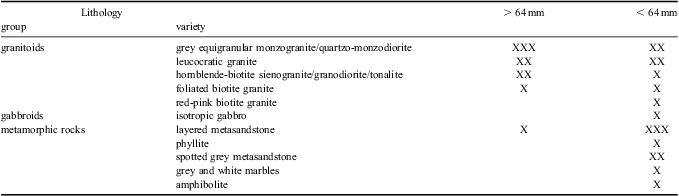
Table I Lithological composition of basement clasts (gravel fraction) in coastal moraine at the base of Mount Discovery.

XXX = very common, XX = common, X = rare.
Visual estimates of relative proportions of different lithological types within gravel-sized debris in the targeted moraine were conducted in the field. Gravel debris is typically dominated by volcanic material, which mainly occurs in the pebble fraction. Olivine bearing basalts, often with prominent vescicular textures, constitute the dominant lithology. At several sample locations the volcanic component also includes minor amounts of rusty red pebbles of felsic composition and cobbles and pebbles of dolerite, most probably sourced from the Ferrar Supergroup. Quarzarenite boulders, probably derived from the Beacon Supergroup, are also common. Other rock types within the gravel fraction include a range of basement lithologies (granitoids, gabbroids, and metamorphic rocks) and are the focus of this paper.
Boulder-sized basement clasts are subrounded to subangular in shape and range up to 2.5 m in their longest dimension. Granitoid boulders are abundant and metasandstones, while present, are less common (Fig. 2) (Table I). The dominant types of granitoid show either isotropic, equigranular or ipidiomorphic textures. Less common mafic-rich granitoids often contain microgranular mafic enclaves that reach up to several centimetres wide. Metasandstone boulders typically exhibit thin greenish quartz-rich layers and thicker grey violet mica-rich layers. The pebble and cobble fraction contains broader compositional variability than recorded in the boulder fraction. The most common rock type is layered metasandstone, which is petrographically similar to the boulders described above. Pebbles and cobbles of phyllite with cordierite poikiloblasts up to 1.5 cm in diameter are also common. Marble and amphibolite erratics are subordinate to other basement rock types.
Petrographic analysis
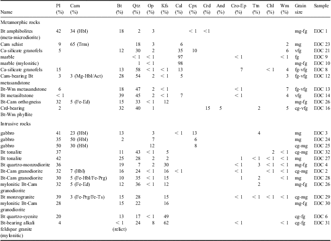
Twenty-four representative samples were selected from the suite of basement lithologies collected from the study site and were prepared for petrographical analysis. Sample thin sections were investigated through a petrological microscope. Metamorphic rock types include a variety of low-grade metasandstones, biotite-muscovite phyllite, actinolite/tremolite bearing schist, amphibolites, marble and calcium-silicate granofels. Igneous rock types include monzogranite, quartz-syenite, alkali feldspar granite, granodiorite, quartz-monzodiorite, tonalite, and gabbro (Table II). Six samples (EOC 12, 15, 23, 26, 28 and 30) were analysed for their microstructures and mineral compositions using an X-ray energy-dispersive system (EDAX-DX4) attached to a scanning electron microscope (Philips XL30) at the Dipartimento di Scienze della Terra of Siena (Italy). Analytical conditions were 20 kV of accelerating voltage, 25 μA of emission current, and a beam spot size of 0.2 μm. Natural minerals were used as standards. In each sample, at least 20 analytical spots from at least four crystals were collected for each mineral.
Table II Petrological features of basement clasts (gravel fraction) in coastal moraine at the base of Mount Discovery. Note: mineral abbreviations according to Kretz (Reference Kretz1983), with the addition of Opm to indicate opaque minerals.
Grain size: vfg = very fine-grained, fg = fine-grained, mg = medium-grained, cg = coarse-grained.
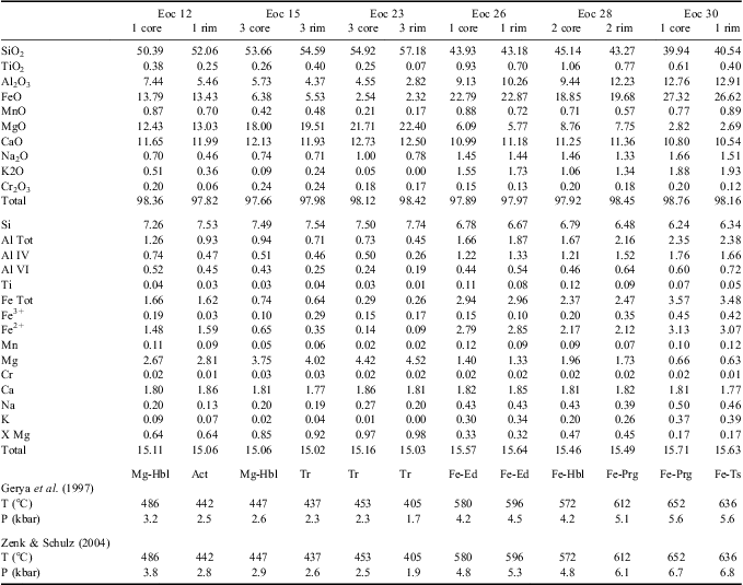
Results from an analysis of the core and rim of Ca-amphibole crystals are presented in Table III. This mineral is common in both intrusive igneous and metamorphic rocks from the region and has been used to constrain clast provenance in previous glacial reconstructions (Talarico et al. 2011).
Table III Representative core and rim compositions of Ca-amphibole and results of Ca-amphibole geothermobarometry for investigated erratics.

The suite of basement erratics comprise low-grade metasediments that include biotite ± muscovite or biotite-actinolite metasandstones, metasiltstones and phyllites (Fig. 3). Metasandstones are very fine- to fine-grained, interlobate granoblastic to granolepidoblastic in texture, with well-preserved bedding and clastic textures. Grains consist of quartz and feldspar, which are set within a recrystallized matrix comprising biotite, muscovite, calcite and rare chlorite. Biotite and muscovite lepidoblasts define continuous cleavage. Biotite metasandstone (sample EOC 12) is characterized by small randomly oriented amphibole (actinolite/Mg-hornblende) idioblasts. Phyllite (sample EOC 15) is heterogranular, very fine- to fine-grained with randomly oriented amphibole idioblasts (tremolite to hornblende or actinolite). Similar texture occurs in cordierite-bearing phyllite (sample EOC 16), in which cordierite poikiloblasts define a prominent spotted texture. Ca-amphibole schist (sample EOC 28) is equigranular, medium-grained, nematogranoblastic, with isoriented amphibole idioblast (tremolite to Mg-hornblende). Amphibolites are heterogranular, medium- to fine-grained, nematoblastic or decussate in texture. Marbles are inequigranular, fine- to medium-grained and showing subpoligonal to interlobate granoblastic textures with variably developed schistosity. Ca-silicate granofels are equigranular, very fine-grained, interlobate granoblastic in texture.
Fig. 3 Photomicrographs of low-grade to medium-grade metamorphic erratics (left column) and of petrographically similar lithologies (right column) from the Skelton glacier region (see Fig. 1 for location details). a. & b. Biotite-bearing metasandstone (a. clast EOC 13 (cross polarized light), and b. sample 2116T2 (Teall Island) (cross polarized light)). c. & d. Ca-silicate granofels (c. clast EOC 21 (plane polarized light), and d. sample 17123FR27 (Teall Island) (plane-polarized light)). e. & f. Marble (e. clast EOC 8 (cross polarized light), and f. sample 17103FR31 (upper Skelton Glacier) (cross polarized light)). g. & h. Amphibolite (g. clast EOC 1, and h. sample 2416F12 (Mount Rich-Darwin Glacier)).
Boulder–pebble sized igneous intrusive erratics are dominated by isotropic biotite ± hornblende granodiorite and foliated or mylonitic biotite granite/granodiorite and smaller numbers of un-deformed biotite alkali-feldspar granite, biotite quartz-monzodiorite, biotite tonalite and gabbro (Figs 4 & 5). Biotite + hornblende granodiorite samples are mainly heterogranular, coarse- to medium-grained, with hypidiomorphic textures. Some samples include poikilitic amphibole or secondary chlorite in their mineral assemblage. Granodiorite (sample EOC 28) shows hypidiomorphic granular texture with small randomly oriented amphibole (Fe-hornblende to Fe-pargasite). Foliated biotite granite and mylonitic biotite granodiorite specimens are heterogranular, fine- to medium-grained, with porphyroclasts set within a fine-grained interlobate granoblastic matrix consisting of neoblastic quartz and feldspars. Mylonitic granodiorites (samples EOC 26 and EOC 30) are heterogranular, fine- to medium-grained with isoriented biotite and amphibole (Fe-edenite in EOC 26, Fe-pargasite to Fe-tschermakite in EOC 30). Quartz-monzodiorite, quartz syenite, alkali feldspar granite and tonalite are heterogranular with hypidiomorphic textures. Samples of gabbro exhibit intergranular igneous textures with subhedral, zoned, complexly twinned laths of plagioclase and relic clinopyroxenes that are often completely replaced by hornblende.
Fig. 4 Photomicrographs (cross polarized light) of felsic intrusive erratics (left column) and of petrographically similar lithologies from the Skelton-Darwin glacier region (right column) (see Fig. 1 for location details). a. & b. Monzogranite showing phenocrysts of K-feldspar set in fine-grained quartz-rich matrix (a. clast EOC 29, and b. sample 2116F14 (Cooper Nunatak)). c. & d. Quartz syenite (c. clast EOC 6, and d. sample 24106F7 (Cheney Bluff)). e. & f. Mylonitic granodiorite showing a strained plagioclase (Pl) porphyroclast that is warped by a marked foliation defined by biotite and recrystallized quartz (e. clast EOC 26, and f. sample 214106F13 (Mount Rich, Carlyon Glacier area)). g. & h. Mylonitic alkali feldspar granite with strained microcline (Mc-I) porphyroclasts surrounded by subpolygonal granoblastic aggregates of neoblastic microcline and quartz (Mc-II + Qtz) (g. clast EOC 31, and h. sample 21106F11 (Cape Murray)).
Fig. 5 Photomicrographs (cross polarized light) showing examples of tonalite, gabbro and amphibolite erratics (left column) and petrographically similar lithologies (right column) from the Darwin-Carlyon glacier region (see Fig. 1 for location details). a. & b. Tonalite (a. clast EOC 27, and b. sample 2416F10 (Cooper Nunatak)). c. & d. Gabbro (c. clast EOC 3, and d. sample 2416F4 (lower Carlyon Glacier area near Fountain Bluff )).
Metamorphic facies analysis
The most common metamorphic rock types in the suite of basement erratics examined in this study are metasandstone and phyllite. These rocks exhibit biotite + muscovite ±calcite ± actinolite paragenesis, which is diagnostic of a regional metamorphic peak under greenschist-facies conditions (Bucher & Frey Reference Bucher and Frey1994). Slightly higher grade metamorphic conditions, ranging between greenschist and lower amphibolite facies, are indicated by mineral assemblages in samples of amphibolite (hornblende + Ca-rich plagioclase), Ca-silicate granofels (diopside + Ca-rich plagioclase), and fine- to medium-grained marble. Several metasandstone (e.g. sample EOC 12) and amphibole-bearing or cordierite-bearing phyllite samples (e.g. sample EOC 16) exhibit fabrics characteristic of contact metamorphism. Furthermore, the type of neoblastic mineral contained in the phyllite samples (i.e. cordierite or hornblende) suggest that thermometamorphic overprint occurred at hornblende hornfels conditions (Bucher & Frey Reference Bucher and Frey1994).
Quantitative constrains on the P-T conditions that occurred during the metamorphic evolution of erratics examined in this study (and therefore in their source rock units), were obtained by analysing Ca-amphibole composition, (after Zenk & Schulz (Reference Zenk and Schulz2004) and Gerya et al. (Reference Gerya, Perchuk, Triboulet, Audren and Sez'ko1997)).
Results of this analysis are listed in Table III and are consistent with the metamorphic facies assignments based on petrographic analyses. Furthermore, analyses indicate medium P conditions occurred during regional metamorphism and much lower P values characterized the contact metamorphic overprint.
Both petrographic features and metamorphic facies that characterize the suite of basement erratics can be compared with lithologically similar rocks exposed in the TAM to identify the most likely source for the erratics. We identify four potential source regions based on geological criteria defined by Stump (1995) in his review of the Ross Orogen: 1) Pensacola and Thiel mountains, 2) Queen Maud and Horlick mountains, 3) central TAM, and 4) SVL between Byrd and Ferrar glaciers. A summary of each basement erratic lithology and its potential parent unit is presented in Table IV.
Table IV List of basement erratic samples examined in this study, their lithology, and possible rock formation from which they may have been derived. Main source of outcrop data from Stump (Reference Stump1995, and references therein) and from Gunn & Warren (1964).
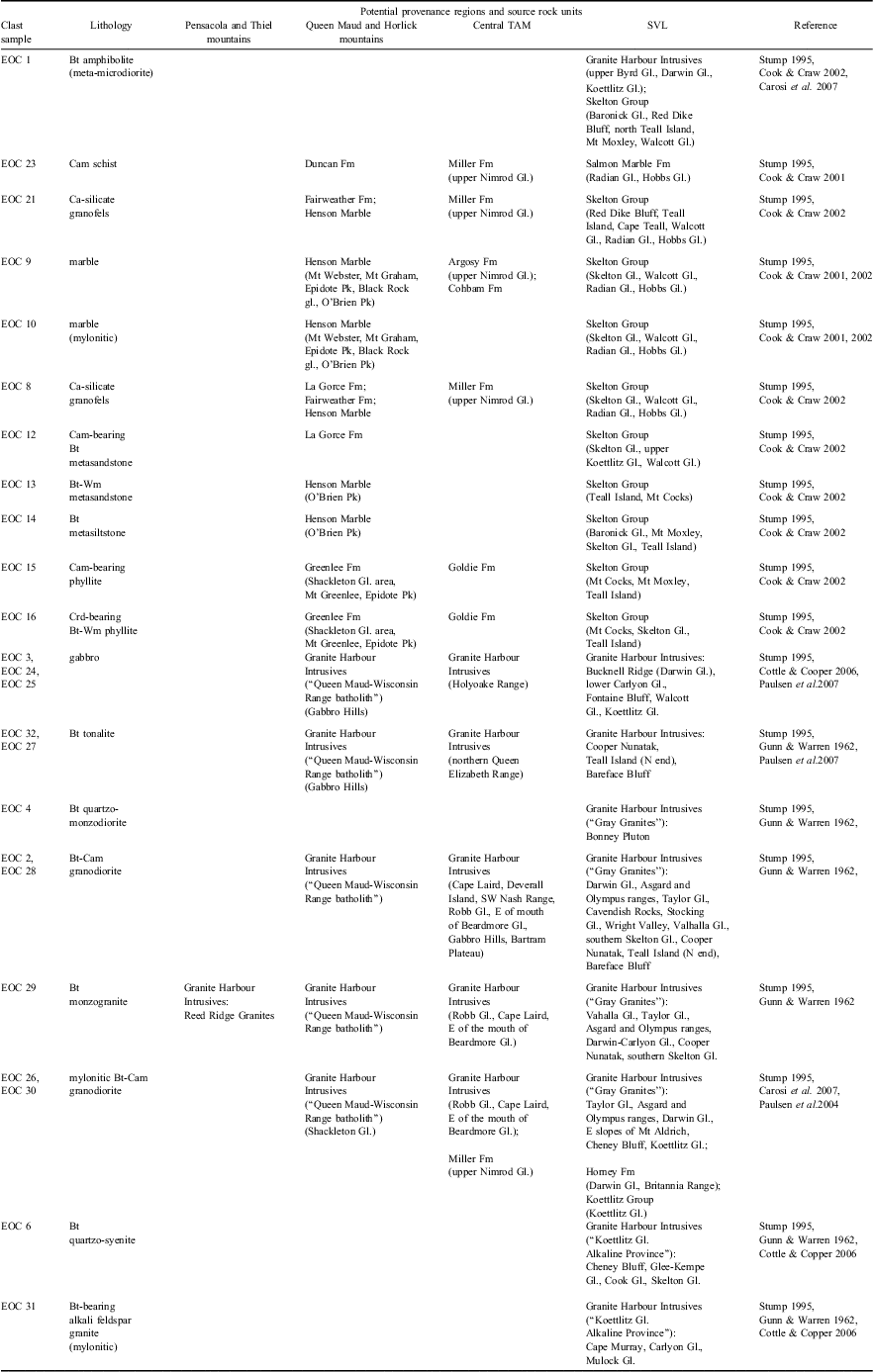
Black Rock glacier is an unofficial name. SVL = southern Victoria Land.
Rock units in the Pensacola and Thiel Mountains primarily comprise lithologies that are distinct from those in the suite of basement erratics and are unlikely to be the source (Table IV). Rock units exposed in the Queen Maud and Horlick mountains, central TAM and SVL all comprise lithologies that are similar to those in the suite of basement erratics (Table IV). However, there are many lithologies in the suite of basement erratics (i.e. quartz syenite, alkali feldspar granite, quartz monzodiorite) that are not known from the Queen Maud/Horlick Mountain region. Furthermore, some of the common rock types that occur in the Queen Maud/Horlick Mountain region (i.e. rhyolites, sandstone, and limestone) were not recovered in the suite of erratics. Therefore, we consider that the Queen Maud and Horlick mountains area is an unlikely source region. Moreover, rock units exposed in the central TAM comprise distinctive rock types including fossiliferous, sometimes weakly metamorphosed, limestones of the Byrd Group and amphibolite facies or higher grade metamorphic rocks (para- and ortho-gneiss, kyanite schists) of the Nimrod Group. None of these lithologies were recovered from the study area at Mount Discovery. Based on this review of broad-scale lithological characteristics we conclude that the SVL segment of the TAM represents the region from which the basement erratics were derived. Specifically, we suggest that the area between Carlyon and Skelton glaciers is the most likely source region as it includes intrusions of alkali-feldspar granite, quartz syenite and quartz monzodiorite (Stump 1995, Paulsen et al. 2004), all of which occur in the suite of basement erratics.
To test this initial interpretation we compared data from the suite of basement erratic samples with published information and over 600 hand specimens and associated thin sections from basement rocks collected from 45 localities in SVL. In particular, we compared petrographic features (Figs 3–5), modal mineralogical data (Table II), and rock microstructure. In addition, we compared the chemical composition of Ca-amphibole (e.g. Fig. 6). Results of these analyses highlight prominent similarities between the basement erratic samples and lithologies exposed in the region between Carlyon and Skelton glaciers.
Fig. 6 Compositional diagram showing the compositional variability of Ca-amphibole in investigated erratics and their similarity with samples of potential rock units in the region between Skelton and Mulock glaciers and Britannia Range (metamorphic rocks) (Talarico et al. Reference Talarico, McKay, Powell, Sandroni and Naish2012) and with southern Victoria Land intrusive rocks (Cottle & Cooper 2002 and references therein, Cook Reference Cook2007, Talarico et al. Reference Talarico, Pace and Sandroni2011).
Late Neogene glacial history and source of Eocene sedimentary erratics
Many previous studies have shown that provenance data are a useful tool to reconstruct glacial flow lines at the time of maximum advance of marine-based ice sheets across the Ross embayment. (Last Glacial Maximum (LGM): Stuiver et al. Reference Stuiver, Denton, Hughes and Fastook1981, Denton & Hughes Reference Denton and Hughes2002, Licht et al. Reference Licht, Lederer and Swope2005; Pliocene/upper Miocene: Talarico et al. Reference Talarico, Pace and Sandroni2011, Reference Talarico, McKay, Powell, Sandroni and Naish2012; middle–lower Miocene: Talarico & Sandroni Reference Talarico and Sandroni2011).
Our petrographic analysis indicates that basement erratics in coastal moraine at the base of Mount Discovery were carried into southern McMurdo Sound by ice most likely flowing from the Skelton, Mulock, and Carlyon glaciers. Basement erratics were probably eroded during one or more glacial advances, carried into the Ross Sea, and pushed north-westwards around Minna Bluff into southern McMurdo Sound by an expanded West Antarctic Ice Sheet (Fig. 7a). This inferred pattern of glacial flow is consistent with previous studies of Pleistocene glacial drift (Wilson Reference Wilson2000, Denton & Hughes Reference Denton and Hughes2002), upper Miocene–Pleistocene sediments in the AND-1B drill core (Talarico et al. Reference Talarico, McKay, Powell, Sandroni and Naish2012) and lower Miocene strata in the AND-2A drill core (Talarico & Sandroni Reference Talarico and Sandroni2011; Talarico et al. Reference Talarico, Pace and Sandroni2011).
Fig. 7 a. Reconstruction of the grounded ice sheet in the Ross embayment at the Last Glacial Maximum after Denton & Hughes (Reference Denton and Hughes2002). b. Ice flow pattern indicated by the provenance investigation on pebble to boulder-size clasts of basement rocks occurring in coastal moraines at the flank of Mount Discovery.
It is important to note that a different ice flow pattern was proposed by Stuiver et al. (1981) who indicate that major East Antarctic outlet glaciers exited the TAM, flowed from the Queen Maud Mountains northwards along the front of the TAM to SVL. However, this reconstruction suggests a much broader potential source region for the McMurdo erratics than is indicated by results from this study.
Furthermore, glacial reconstructions based on detailed provenance studies and glacial dynamic models by Licht et al. (2005) indicate that only flow lines from Byrd Glacier and outlet glaciers reached the McMurdo Sound area during the LGM.
Therefore, we further rule out the possibility that the basement gravel erratics were derived from areas south of the Byrd Glacier. This interpretation is consistent with the evidence discussed in the previous section. Outlet glaciers of the Skelton-Byrd glacier area are the most likely source region for the basement clasts in the moraine bands at Mount Discovery. These results suggest that the Eocene sedimentary erratics also come from an area near the Skelton and Carlyon glaciers.
Consequently these results support previous suggestions that the Eocene erratics were eroded from a deep subglacial basin (“Discovery Deep”) south of Minna Bluff (Harwood & Levy Reference Harwood and Levy2000). However, these new provenance data constrain the probable location of parent outcrop to the central and northernmost part of “Discovery Deep” (Fig. 7b).
Conclusions
Basement lithologies in the pebble- to boulder-size erratics in moraine bands at Mount Discovery are similar to rock units exposed in the Ross Orogen in SVL. A petrographic analysis of this debris indicates that gravel clasts are comparable to lithological units exposed between the Skelton and Mulock glaciers and immediately south of Carlyon Glacier. These new data refine inferences regarding the provenance of Eocene sedimentary erratics that also occur in the Mount Discovery moraines. Whereas, previous studies suggested an origin south of Minna Bluff, this study indicates that the sedimentary erratics were most likely eroded from the north and north-eastern portion of “Discovery Deep” and/or from grabens in basement highs immediately south-east of Minna Bluff. Future efforts to identify potential drill sites to recover in situ Eocene rocks should focus on the region offshore of Skelton and Mulock glaciers. Provenance data also support Pleistocene glacial reconstructions proposed in previous studies and further highlight the value that analyses of basement clasts add to studies of past ice sheet behaviour.
Acknowledgements
We would like to acknowledge M. Flowerdew, T. Paulsen and S. Rocchi for their helpful comments and suggestions. The ANDRILL Science Management Office at the University of Nebraska-Lincoln provided operational support during fieldwork. This research was carried out with the financial support of the Italian Programma Nazionale di Ricerche in Antartide and PRIN2008.