


Introduction
Tidewater glaciers on the western Antarctic Peninsula have undergone substantial termini retreat and flow acceleration in response to increased air and ocean temperatures over the last half-century or so (Vaughan et al. Reference Vaughan, Marshall, Connolley, Parkinson, Mulvaney and Hodgson2003, Cook et al. Reference Cook, Fox, Vaughan and Ferringo2005, Reference Cook, Holland, Meredith, Murray, Luckman and Vaughan2016). In addition, the retreat and loss of floating ice shelves on the western Antarctic Peninsula, including the Wordie, Müller and Wilkins ice shelves, have been attributed to the southerly migration of the −9°C isotherm in response to regional warming (Morris & Vaughan Reference Morris and Vaughan2003).
Studies of the former configuration and dynamics of glaciers and ice sheets are motivated by the need to constrain numerical models and provide a context for satellite-era observations of outlet-glacier retreat. Whereas aerial and satellite imagery reveal the changing extent of glaciers over the past few decades (e.g. Cook et al. Reference Cook, Holland, Meredith, Murray, Luckman and Vaughan2016), bathymetric data of the formerly glacierized seafloor can provide information about glacier behaviour prior to the widespread application of remote-sensing techniques (e.g. Anderson Reference Anderson1999, Shipp et al. Reference Shipp, Wellner, Anderson, Dowdeswell and Ó Cofaigh2002, Dowdeswell et al. Reference Dowdeswell, Canals, Jakobsson, Todd, Dowdeswell and Hogan2016). An important application of bathymetric data is that the identification and interpretation of submarine glacial landforms can reveal the style and relative rate of past ice retreat (Dowdeswell et al. Reference Dowdeswell, Ottesen, Evans, Ó Cofaigh and Anderson2008), which is important for predicting the likely future ice-sheet response to climatic change.
In contrast to Arctic and sub-Arctic fjords, where numerous geomorphic and stratigraphic investigations have revealed the complexity of glacimarine systems and enabled the development of detailed land-system models (e.g. Ottesen & Dowdeswell Reference Ottesen and Dowdeswell2006, Hjelstuen et al. Reference Hjelstuen, Kjennbakken, Bleikli, Ersland, Kvilhaug, Euler and Alvheim2013), high-resolution studies of the seafloor beyond tidewater glaciers on the Antarctic Peninsula are relatively sparse (Anderson Reference Anderson1999, García et al. Reference García, Dowdeswell, Noormets, Hogan, Evans, Ó Cofaigh and Larter2016, Munoz & Wellner Reference Munoz and Wellner2018). The lack of high-resolution bathymetry from Antarctic Peninsula fjords and embayments hinders our understanding of glacimarine processes and past ice dynamics in these locations. The observed retreat of glacier termini on the western Antarctic Peninsula has been interpreted to be caused, at least in part, by the increasing incursion of warm subsurface circumpolar deep water (CDW) across the continental shelf to the ice margin (Holland et al. Reference Holland, Jenkins and Holland2010, Cook et al. Reference Cook, Holland, Meredith, Murray, Luckman and Vaughan2016, Gunn et al. Reference Gunn, White, Larter and Caulfield2018). Access of warm subsurface waters to tidewater–glacier margins is controlled strongly by the water depth of the fjord or bay in which the glacier terminates (Walker et al. Reference Walker, Brandon, Jenkins, Allen, Dowdeswell and Evans2007, Jacobs et al. Reference Jacobs, Jenkins, Hellmer, Giulivi, Nitsche, Huber and Guerrero2012); this provides further motivation to map the depth of the seafloor beyond tidewater glaciers on the Antarctic Peninsula.
In this paper, we present very-high-resolution bathymetric data from close to the margin of a tidewater glacier in Darbel Bay, western Antarctic Peninsula (Fig. 1) in order to map and interpret the glacial landforms that are preserved on the seafloor. This area typically experiences significant sea-ice cover through the Antarctic summer, which has historically prevented the collection of bathymetric data. These data are discussed in relation to the pattern of past ice flow in Darbel Bay and processes of glacier-influenced sedimentation on the Antarctic Peninsula more generally. Furthermore, we use satellite imagery to investigate the age of the seafloor glacial landforms, document the recent termini retreat of the tidewater glaciers that drain into Darbel Bay and examine the controls on their short-term (annual to decadal) variable behaviour.

Fig. 1. a. Map of part of the western Antarctic Peninsula showing the location of Darbel Bay (red box). Background is International Bathymetric Chart of the Southern Ocean (IBCSO) bathymetry with 200 m contours (Arndt et al. Reference Arndt, Schenke, Jakobsson, Nitsche, Buys and Goleby2013). B = Bourgeois Fjord; DC = Danco Coast; L = Lallemand Fjord. b. Satellite image of Darbel Bay showing the locations of ten tidewater glaciers. Coloured lines show glacier-termini positions since 1974. Background is a LANDSAT 8 satellite image acquired in January 2016. Inset shows location of a. in Antarctica. WC = Widdowson Cove.
Geological and glaciological framework
Darbel Bay is a wide (up to 50 km) embayment on the western side of the northern Antarctic Peninsula (Fig. 1). Ten tidewater glaciers, with termini widths of between 1 and 9 km, drain into Darbel Bay from the Antarctic Peninsula Ice Sheet (APIS) in Graham Land. During the last glacial maximum (LGM) c. 25 000 years ago, the APIS expanded through Darbel Bay and across the c. 200 km-wide continental shelf (Fig. 1a) (Pudsey et al. Reference Pudsey, Barker and Larter1994, Larter & Vanneste Reference Larter and Vanneste1995, Anderson et al. Reference Anderson, Shipp, Lowe, Wellner and Mosola2002, Ó Cofaigh et al. Reference Ó Cofaigh, Davies, Livingstone, Smith, Johnson and Hocking2014, Lavoie et al. Reference Lavoie, Domack, Pettit, Scambos, Larter and Schenke2015). A well-preserved assemblage of glacial landforms, including mega-scale glacial lineations and drumlins that are produced subglacially, provides evidence that a fast-flowing ice stream extended through Biscoe Trough to the shelf break during the LGM (Lavoie et al. Reference Lavoie, Domack, Pettit, Scambos, Larter and Schenke2015).
The APIS retreated from the shelf break beyond Biscoe Trough between c. 17.5 and 14.0 ka (Heroy & Anderson Reference Heroy and Anderson2007, Ó Cofaigh et al. Reference Ó Cofaigh, Davies, Livingstone, Smith, Johnson and Hocking2014). Although the deglacial and Holocene histories of the glaciers that drain into Darbel Bay are uncertain, the neighbouring Lallemand Fjord (Fig. 1a) is known to have deglaciated by 8 ka and experienced open-marine conditions between c. 8.0 and 2.7 ka (Domack et al. Reference Domack, Ishman, Stein, McClennen and Jull1995, Shevenell et al. Reference Shevenell, Domack and Kernan1996). An advance of the Müller Ice Shelf in Lallemand Fjord occurred c. 400 years ago, which broadly corresponds with the timing of Little Ice Age cooling in the Northern Hemisphere (Domack et al. Reference Domack, Ishman, Stein, McClennen and Jull1995).
At present, warm (c. 3°C above the seawater freezing temperature) and saline CDW is prevalent across the Bellingshausen Sea continental shelf below a water depth of c. 200–250 m, and it is overlain by colder and fresher winter water and a surface mixed layer (Holland et al. Reference Holland, Jenkins and Holland2010, Cook et al. Reference Cook, Holland, Meredith, Murray, Luckman and Vaughan2016, Gunn et al. Reference Gunn, White, Larter and Caulfield2018). There are concerns that the thickness of the CDW layer is increasing in response to increased ocean heat content in the Bellingshausen Sea (Martinson et al. Reference Martinson, Stammerjohn, Iannuzzi, Smith and Vernet2008, Schmidtko et al. Reference Schmidtko, Heywood, Thompson and Aoki2014).
Methods
The bathymetric data used in this study were collected by the British Royal Navy ice patrol vessel HMS Protector in January 2018. A small survey motor boat (SMB), the James Caird IV, was used to acquire data covering an area of c. 1.5 km2 from close to the terminus of Philippa Glacier (Fig. 2). The SMB James Caird IV is fitted with a hull-mounted, Kongsberg EM2040 multi-beam echo-sounding system (MBES) that operates with frequencies in the 200–400 kHz range. Vertical and horizontal resolution are c. 1.0 and 0.5 m, respectively. The MBES performed well in water depths shallower than c. 290 m. Data processing to remove erroneous soundings and production of maps were performed with Caris and Fledermaus software.
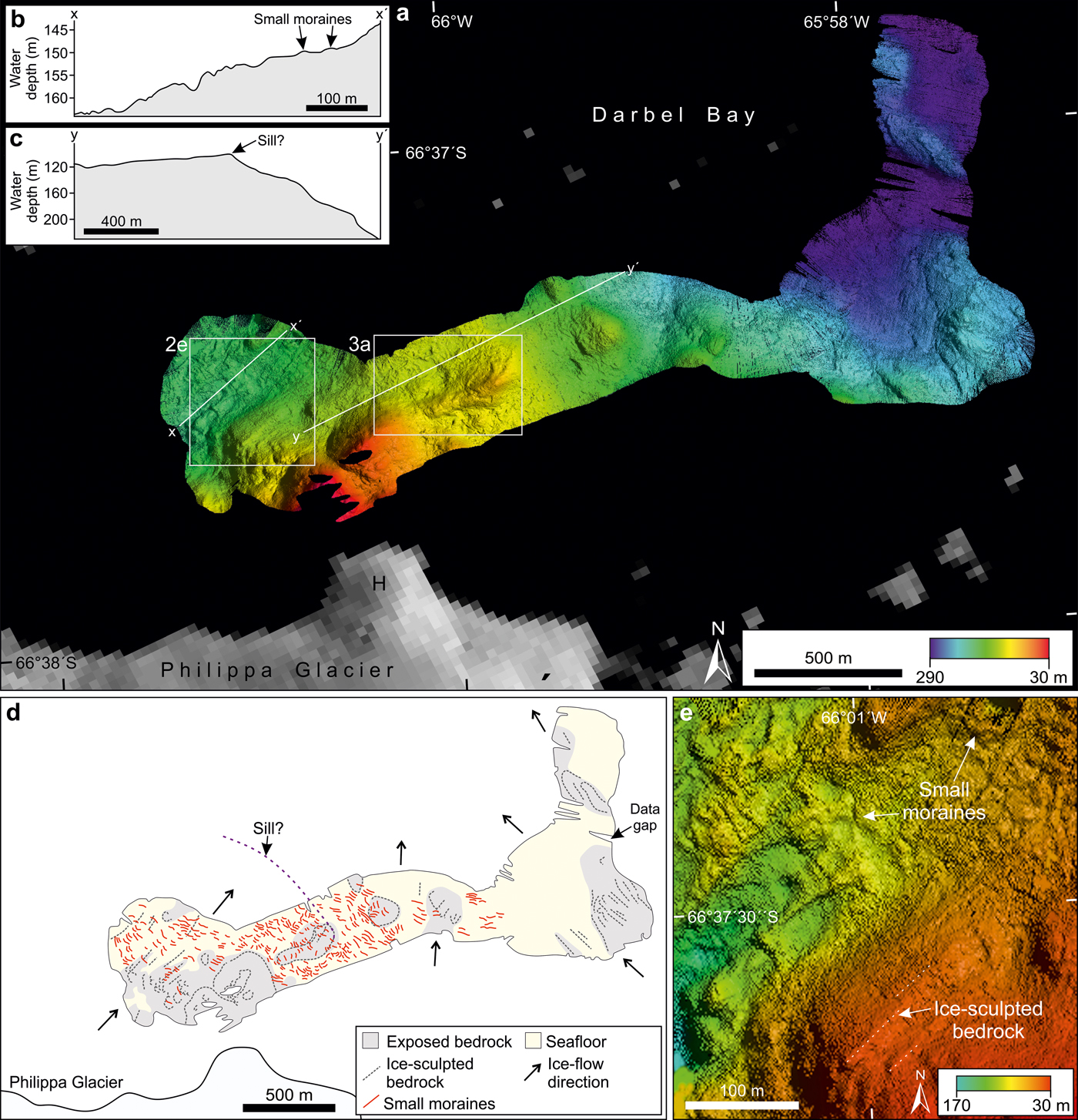
Fig. 2. a. Bathymetric data from the seafloor beyond the margin of Philippa Glacier. Grid-cell size = 2 m. Location is shown in Fig. 1b. H = headland in the ice margin. b. and c. Long profiles showing the changing seafloor depth away from the ice margin. d. The mapped distribution of submarine landforms in the area shown in a. e. Detail showing ice-sculpted bedrock and small recessional moraines. Grid-cell size = 2 m.
Glacier-terminus change information and glacier catchment areas were mapped from LANDSAT satellite images for the period 1974–2016 (Fig. 1b). The satellite images were acquired during the Antarctic summer, between January and March, and were downloaded from Earth Explorer (https://earthexplorer.usgs.gov).
Results
Bathymetry
Our bathymetric data show that the seafloor 0.5–1.0 km beyond the terminus of Philippa Glacier is between 140 and 170 m deep (Fig. 2a & b). The seafloor shallows rapidly, to c. 30 m, at the eastern lateral margin of the glacier, where data were collected to within 100 m of a prominent headland (Fig. 2a). The seafloor depth increases seaward of this bathymetric high, reaching c. 290 m at the northern limit of the dataset. Some areas of the seafloor have a rough and irregular character, which is interpreted as exposed or shallowly buried bedrock (Fig. 2d).
Two types of landforms are present on the seafloor beyond Philippa Glacier: elongate ridges and small transverse ridges.
Sets of parallel to subparallel elongate ridges made up of exposed or near-surface bedrock features are common in the study area (Fig. 2d & e). The seafloor immediately beyond Philippa Glacier has a south-west–north-east structural component, whereas linear seafloor elements to the north appear to be arranged in a south-east–north-west direction (Fig. 2d). The elongate bedrock ridges are a few metres high and can be traced for up to 200 m.
More than 250 small, subparallel ridges are identified in water depths of between 70 and 200 m (Fig. 2). The ridges are < 1–3 m tall, 10–20 m wide and spaced between 5 and 30 m apart (Fig. 3a & b). They have linear to arcuate geometries in plan form and occur as discontinuous segments that are < 50 m in length. The transverse ridges are identified as overprinting regions of the seafloor that are interpreted as exposed or near-surface bedrock (Fig. 2d). They have a generally south-east–north-west orientation, which is perpendicular to the ice-flow direction of Philippa Glacier (Fig. 2d).

Fig. 3. a. Detail showing recessional moraines beyond the margin of Philippa Glacier. Location is shown in Fig. 2a. Grid-cell size = 5 m. b. Long profile showing the dimensions of the recessional moraines (black arrows) shown in a. c. Bathymetric image showing recessional moraines beyond the margin of a tidewater glacier in Kollerfjorden, north-west Spitsbergen. Grid-cell size = 1 m. Modified from Burton et al. (Reference Burton, Dowdeswell, Hogan and Noormets2016). d. Long profile showing the dimensions of the recessional moraines (black arrows) shown in c. Modified from Burton et al. (Reference Burton, Dowdeswell, Hogan and Noormets2016). e. Comparison of morphological parameters of the recessional moraines shown in a. and c.
The seafloor immediately beyond the terminus of Philippa Glacier is interpreted to have been affected by glacial erosion during periods in which the glacier was more extensive than it is at present. Long profiles of the seafloor away from the ice front (Fig. 2b & c) suggest that a sill, or possibly even a large moraine, may be present c. 2 km seaward of the present-day terminus, beyond our data coverage (Fig. 2d).
The elongate bedrock ridges (Fig. 2d & e) are interpreted as ice-sculpted bedrock that indicates the direction of past ice flow. Bedrock is moulded and shaped as it is overridden by glacial ice, producing sculpted or streamlined bedrock forms, and this is a common feature of rocky areas of glaciated fjords and inner-shelf environments (Graham et al. Reference Graham, Larter, Gohl, Hillenbrand, Smith and Kuhn2009, Larter et al. Reference Larter, Graham, Gohl, Kuhn, Hillenbrand and Smith2009, Dowdeswell et al. Reference Dowdeswell, Canals, Jakobsson, Todd, Dowdeswell and Hogan2016, Munoz & Wellner Reference Munoz and Wellner2018).
The small, subparallel ridges on the seafloor beyond Philippa Glacier (Figs 2d, e, 3a & b) are interpreted as recessional moraines (sometimes referred to as De Geer moraines; Lindén & Möller Reference Lindén and Möller2005) and are orientated transverse to the past ice-flow direction inferred from ice-sculpted bedrock. These landforms are formed by the delivery and ice pushing of sediment during still-stands or re-advances of a grounded ice margin during overall retreat (Boulton Reference Boulton1986). Groups of similar-sized and evenly spaced moraines are commonly found beyond the termini of tidewater glaciers in Arctic fjords and marine embayments (e.g. Fig. 3c & d) (Ottesen & Dowdeswell Reference Ottesen and Dowdeswell2006, Burton et al. Reference Burton, Dowdeswell, Hogan and Noormets2016). The large number (> 250) and small size (< 1–3 m high) of the recessional moraines beyond Philippa Glacier indicate a relatively slow style of grounded ice retreat in which multiple short-lived re-advances of the ice margin were superimposed upon a general trend of retreat (Dowdeswell et al. Reference Dowdeswell, Ottesen, Evans, Ó Cofaigh and Anderson2008).
Satellite imagery
Satellite images provide evidence on the response of ten neighbouring tidewater glaciers to contemporary climatic changes along a c.100 km-long section of coastline in Darbel Bay (Fig. 1). Since 1974, all of the glaciers in the study area have either maintained a stable terminus position or have undergone overall retreat (Figs 1 & 4). Three different styles of outlet-glacier behaviour are recognized for the last c. 40 years: 1) near-stationary terminus position; 2) relatively small-scale fluctuations in terminus position with gradual overall retreat; and 3) significant (> 1 km), stepped terminus retreat.

Fig. 4. a. Bar chart showing the average change in glacier-terminus position for the ten tidewater glaciers in Darbel Bay since 1974. b. Morphological and physiographical parameters of the tidewater glaciers draining into Darbel Bay. c. Graph showing the weak positive relationship between the range of glacier-terminus fluctuation since 1974 and glacier drainage basin size. HG = Hopkins Glacier; KG = Keith Glacier; WG = Widdowson Glacier.
Three of the tidewater glaciers in Darbel Bay (Peter, Philippa and Cardell glaciers) have experienced very little variation in their termini positions over the past four decades (Figs 1 & 4).
Four of the glaciers (McCance, Drummond, Lampe and Erskine glaciers) have undergone an overall retreat of 0.5–2.4 km that includes relatively small-scale changes in termini positions (Figs 1 & 4). Small-scale changes in the plan-form shape of the ice margin are probably the result of iceberg calving and may be related to water-depth variations at the grounding line. Erskine Glacier experienced the greatest variation in plan-form terminus shape, with the disappearance, regrowth and subsequent breakup of a 2 km-long ice promontory occurring between 1986 and 2011 (Fig. 1b), which probably regrows to a shallower submarine pinning point.
Three of the tidewater glaciers in Darbel Bay (Widdowson, Hopkins and Keith glaciers) have undergone significant, stepped retreat since 1974 (Figs 1 & 4). The greatest retreat was experienced by Widdowson Glacier, which retreated c. 4.4 km between 1991 and 1999 (average retreat rate of 550 m/year), leading to the formation of Widdowson Cove (Fig. 1b). Hopkins Glacier has retreated c. 3.1 km since 1974, including significant terminus retreat of c. 1 km, between 1991 and 1999 (average retreat rate of c. 120 m/year). After remaining relatively stable since 1974, the terminus position of Keith Glacier retreated c. 1 km between 1999 and 2001 (average retreat rate of 500 m/year).
Discussion
The former pattern of ice flow beyond Philippa Glacier
Historical satellite images show that the assemblage of submarine glacial landforms beyond Philippa Glacier (Fig. 2d) was produced or last modified prior to 1974, when such imagery first became available. The distribution and orientation of ice-sculpted bedrock records the former pattern of ice flow when Philippa Glacier was more extensive than it is at present. Relatively fast-moving ice is interpreted to have extended in a north-easterly direction beyond Philippa Glacier and to have become confluent with north-westerly flowing ice in the deeper, central axis of Darbel Bay, which was fed by the other glaciers in the bay (Fig. 2d). The broad-scale bathymetry of the western Antarctic Peninsula suggests that ice in Darbel Bay may have nourished one or more of the ice streams that extended to the shelf break through Biscoe and Adelaide troughs during the LGM (Fig. 1a) (Ó Cofaigh et al. Reference Ó Cofaigh, Davies, Livingstone, Smith, Johnson and Hocking2014).
The small recessional moraines beyond Philippa Glacier (Figs 2, 3a & b) indicate the slow retreat of a grounded ice margin (Dowdeswell et al. Reference Dowdeswell, Ottesen, Evans, Ó Cofaigh and Anderson2008). The recessional moraines were probably produced during either regional deglaciation following the LGM or subsequent to a Holocene advance of the glacier terminus. Although it is uncertain whether the outlet glaciers of the APIS underwent a regional response to Little Ice Age cooling between c. 1300 and 1850, evidence for ice-sheet advance during this time has been recorded from Lallemand Fjord and Bourgeois Fjord, which are c. 60 and 100 km south of Darbel Bay, respectively (Fig. 1a) (Domack et al. Reference Domack, Ishman, Stein, McClennen and Jull1995, Shevenell et al. Reference Shevenell, Domack and Kernan1996, García et al. Reference García, Dowdeswell, Noormets, Hogan, Evans, Ó Cofaigh and Larter2016). On the Danco Coast to the north, moraines up to 30 m high and between 1 and 4 km beyond the present-day ice margin are interpreted to have been formed during the Little Ice Age (Munoz & Wellner Reference Munoz and Wellner2018). The tentative interpretation of a sill or large moraine c. 2 km beyond the present-day ice margin (Fig. 2c & d) suggests that it is possible that Philippa Glacier also experienced a re-advance during this time.
Processes and patterns of glacier-influenced sedimentation in Darbel Bay
Although similar glacial landforms have been reported previously from the continental shelf of Antarctica (e.g. Shipp et al. Reference Shipp, Wellner, Anderson, Dowdeswell and Ó Cofaigh2002, Klages et al. Reference Klages, Kuhn, Hillenbrand, Graham, Smith, Larter and Gohl2016), the moraines identified beyond Philippa Glacier are the first suite of relatively evenly spaced, small, recessional moraines reported from an Antarctic Peninsula fjord or embayment. This is probably a consequence of the generally coarse data resolution and incomplete data coverage from ice-marginal settings on the Antarctic Peninsula, rather than atypical behaviour of Philippa Glacier. The identification of subdued transverse features, including recessional moraines, on bathymetric images is important for understanding the rate and style of former ice retreat (Dowdeswell et al. Reference Dowdeswell, Ottesen, Evans, Ó Cofaigh and Anderson2008). The assumed absence of small, transverse features from the seafloor (e.g. due to coarse data resolution) could be misinterpreted as a signal of rapid grounding-line retreat.
The small size of the recessional moraines beyond Philippa Glacier, which have heights of < 1–3 m and widths of 10–20 m, show that tidewater glaciers on the Antarctic Peninsula can undergo short-lived adjustments in their grounding-line positions. It is possible that the moraines were formed annually, with minor ice-margin re-advances taking place, for example, in response to the suppression of iceberg calving by sea-ice buttressing during winter months (Boulton Reference Boulton1986, Dowdeswell et al. Reference Dowdeswell, Ottesen, Evans, Ó Cofaigh and Anderson2008).
The small, recessional moraines beyond Philippa Glacier have comparable dimensions and geometries to transverse-to-flow moraines that have been identified beyond the margins of several tidewater glaciers in Svalbard (Fig. 3) (e.g. Ottesen & Dowdeswell Reference Ottesen and Dowdeswell2006, Burton et al. Reference Burton, Dowdeswell, Hogan and Noormets2016). The environmental setting of a glaciated region provides a first-order control on the patterns and processes of sedimentation that occur at the ice margin (Dowdeswell et al. Reference Dowdeswell, Elverhøi and Spielhagen1998, Reference Dowdeswell, Canals, Jakobsson, Todd, Dowdeswell and Hogan2016). The similar size of the recessional moraines on the Antarctic Peninsula and Svalbard is therefore probably a consequence of the broadly similar climatic and oceanographic regimes of these regions, in which mass can be lost through surface-meltwater production, especially in summer months, as well as through iceberg calving and the melting of frontal ice cliffs. In contrast, glaciers in West and East Antarctica are restricted to minimal surface-meltwater production, whilst glaciers that terminate in the mild fjords of Chile and south-east Alaska lose the majority of their mass through surface-meltwater production and runoff (Dowdeswell et al. Reference Dowdeswell, Canals, Jakobsson, Todd, Dowdeswell and Hogan2016).
An interesting contrast between the recessional moraines in Darbel Bay and in the fjords of Svalbard is that the former occur as a series of discontinuous segments, whereas the latter tend to be continuous across the width of the fjord (Fig. 3). The discontinuous nature of the recessional moraines in Darbel Bay may be a consequence of limited and/or irregular sediment cover over bedrock beyond Philippa Glacier. In contrast, the moraines in the fjords of Svalbard appear to overlie a sedimentary substrate, which may have provided a more laterally extensive and/or thicker source of sediment for the formation of moraine ridges through ice-pushing of sediment during short-lived re-advances of the grounding line.
The preservation of subdued glacial landforms on the seafloor beyond Philippa Glacier shows that this area experiences relatively low rates of glacier-derived sedimentation. In agreement with other studies (e.g. García et al. Reference García, Dowdeswell, Noormets, Hogan, Evans, Ó Cofaigh and Larter2016, Munoz & Wellner Reference Munoz and Wellner2018), iceberg ploughmarks appear to be absent from the seafloor beyond Philippa Glacier, despite the proximity of the multi-beam data to the ice margin (Fig. 2). The icebergs that are calved today from Philippa Glacier probably have insufficient keel depths to ground on the seafloor given that, in contrast to floating ice shelves, grounded tidewater glaciers tend to produce relatively small icebergs of irregular shape (e.g. Dowdeswell & Bamber Reference Dowdeswell and Bamber2007). The absence of iceberg ploughmarks could also be explained by the prevalence of exposed or near-surface bedrock, which is more difficult than a sedimentary substrate for iceberg keels to incise, or the limited aerial extent of our dataset.
Controls on tidewater glacier retreat on the western Antarctic Peninsula
The tidewater glaciers that drain into Darbel Bay have undergone an overall trend of retreat since the first satellite observations in 1974 (Figs 1b & 4). The behaviour of these glaciers is in agreement with the general pattern of terminus retreat that has been observed for glaciers on the western Antarctic Peninsula since the 1960s (Cook et al. Reference Cook, Fox, Vaughan and Ferringo2005, Reference Cook, Holland, Meredith, Murray, Luckman and Vaughan2016). These changes have been interpreted as a response to an increase in mid-ocean water column (100–300 m water depth) temperature (Cook et al. Reference Cook, Holland, Meredith, Murray, Luckman and Vaughan2016), as well as atmospheric warming and increased summer melt (Morris & Vaughan Reference Morris and Vaughan2003).
The most significant termini retreat of the tidewater glaciers in Darbel Bay on a decadal scale took place between 1991 and 2001, with an average rate of terminus retreat of > 80 m/year (Figs 1b & 4a). This pattern is in agreement with the work of Cook et al. (Reference Cook, Vaughan, Luckman and Murray2014, Reference Cook, Holland, Meredith, Murray, Luckman and Vaughan2016), who identified widespread acceleration of glacier retreat on the western Antarctic Peninsula between 64°S and 70°S during this time. The acceleration of glacier retreat is interpreted to be a consequence of regional warming and the increased temperature and upwelling onto the shelf of CDW since the 1990s (Cook et al. Reference Cook, Holland, Meredith, Murray, Luckman and Vaughan2016).
Whereas the general trend of glacier-termini retreat in Darbel Bay is interpreted to be a response to regional atmospheric and oceanographic forcing, the asynchronous response of individual glaciers (Figs 1b & 4) is probably a consequence of local glaciological and/or topographical factors. It has been suggested previously that recent ice retreat has affected most markedly the extent of smaller ice bodies on the Antarctic Peninsula (Fox & Cooper Reference Fox and Cooper1998, García et al. Reference García, Dowdeswell, Noormets, Hogan, Evans, Ó Cofaigh and Larter2016). In contrast, we find a weak positive correlation between both drainage basin area and terminus width and the range of terminus variation since 1974 (R = 0.23 and R = 0.24, respectively) (Fig. 4b & c). The three glaciers that have experienced very little variation in their termini positions over the past four decades (Peter Glacier, Philippa Glacier and Cardell Glacier) have some of the smallest drainage basin areas in Darbel Bay (Fig. 4b & c). Larger glaciers may experience greater variation in terminus position as a result of their higher ice fluxes; for example, Erskine Glacier has the largest drainage area in Darbel Bay and has undergone periods of both significant advance and retreat during the past few decades (Fig. 1b).
It is likely that local topographical factors also play a significant role in controlling the rate and style of tidewater glacier retreat in Darbel Bay. Land promontories or islands can act as lateral pinning points for ice stabilization during retreat by increasing the lateral drag that is exerted on the glacier (Echelmeyer et al. Reference Echelmeyer, Clarke and Harrison1991). For example, Widdowson Glacier remained relatively stable at a narrow lateral pinning point between 1974 and 1991, before it retreated rapidly through the wider Widdowson Cove (Fig. 1b).
Stability of an ice terminus can also be encouraged by shallow vertical pinning points in the underlying bathymetry. At c. 140–170 m, our bathymetric data show that the seafloor beyond Philippa Glacier (Fig. 2a) is relatively shallow compared with other over-deepened regions of the seafloor beyond the termini of tidewater glaciers on the Antarctic Peninsula, which commonly reach depths of > 500 m (Domack et al. Reference Domack, Ishman, Stein, McClennen and Jull1995, García et al. Reference García, Dowdeswell, Noormets, Hogan, Evans, Ó Cofaigh and Larter2016). In addition to encouraging ice-margin stabilization through reducing the mass flow across the grounding line and slowing the rate of iceberg calving (Echelmeyer et al. Reference Echelmeyer, Clarke and Harrison1991, Schoof Reference Schoof2007), the relatively shallow seafloor beyond Philippa Glacier (Fig. 2a) may prevent the incursion of warm subsurface CDW, which is present below c. 200–250 m on the western Antarctic Peninsula shelf (Cook et al. Reference Cook, Holland, Meredith, Murray, Luckman and Vaughan2016), from reaching the ice front. Although the water depth beyond the other glaciers in Darbel Bay is unknown, it is possible that the relatively shallow seafloor beyond Philippa Glacier has led to reduced melting of the glacier terminus compared with glaciers that terminate in deeper areas of the embayment. Philippa Glacier may also have been less sensitive than neighbouring tidewater glaciers to the climatic and oceanographic changes that occurred prior to the availability of satellite imagery. The relatively slow style of ice-margin retreat that is interpreted to have occurred prior to 1974, as suggested by the small recessional moraines, may also be a consequence of the relatively shallow seafloor beyond this glacier.
Conclusions
• We present the first bathymetric data from Darbel Bay on the western Antarctic Peninsula. An assemblage of glacial landforms, which includes streamlined bedrock and small, recessional moraines, is mapped on the seafloor beyond Philippa Glacier (Fig. 2c). Elongate landforms show the direction of former ice flow through Darbel Bay during the LGM and/or deglaciation, whilst small, recessional moraines indicate the slow retreat of a grounded ice mass.
• Our very-high-resolution bathymetric data show, for the first time, that small (< 1–3 m high) recessional moraines are a part of the landform assemblage produced by tidewater glaciers on the western Antarctic Peninsula, despite the fact that these features have not been identified in marine embayments or fjords before. We suggest that small, recessional moraines may be present in other Antarctic Peninsula fjords and embayments, yet have not hitherto been readily identified because of either coarse bathymetric data resolution and/or limited data coverage.
• The small, recessional moraines in Darbel Bay, which were produced sometime prior to 1974, support inferences from the satellite record that tidewater glaciers on the Antarctic Peninsula can undergo short-lived re-advances in their grounding-line position. The moraines have similar dimensions to recessional moraines that have been identified beyond the margins of tidewater glaciers in Svalbard that may record annual responses to seasonal climatic variations.
• Satellite images show that, since 1974, the tidewater glaciers in Darbel Bay have retreated in line with the general trend of termini retreat that has been observed for glaciers on the Antarctic Peninsula and has been linked to the increased temperature and thickness of CDW. The greatest average rate of termini retreat in Darbel Bay occurred during the 1990s (Fig. 4a).
• However, the ten tidewater glaciers that drain into Darbel Bay have experienced contrasting styles of terminus retreat (Figs 1b, 4b & c). Accepting that the glaciers are likely to have experienced almost identical regional oceanic warming forcing, we attribute the contrasting glacier behaviour to depend mainly on the physiography of the local area, including seafloor depth and fjord width, rather than on the glacier catchment-area size. The importance of local topographical factors on tidewater–glacier dynamics provides strong motivation to collect further bathymetric data using high-resolution multi-beam systems from close to the margins of marine-terminating glaciers.
Acknowledgements
We thank Captain Matthew Syrett, the officers and the crew of the British Royal Navy patrol ship HMS Protector for their help with data acquisition. CLB was in receipt of a Junior Research Fellowship from Newnham College, Cambridge, during this work. KAH and RDL are supported by the Polar Science for Planet Earth programme, funded by the Natural Environment Research Council, UK. We thank two anonymous reviewers for their helpful reviews of this manuscript.
Author contributions
JAD, KAH and RDL devised the project. CLB, EP and OW collected and processed the data. CLB produced the figures and wrote the manuscript, with input from JAD, KAH and RDL.
Details of data deposit
The data will be located in the University of Cambridge's open-access repository.


