


Introduction
Several discoveries made in 1959–60 by the US Victoria Land Traverse (VLT) as part of the US Antarctic Research Program included the earliest significant recognition of contemporary global warming, and our consequent awareness of the ‘Anthropocene’ (Lorius et al. Reference Lorius, Merlivat, Jouzel and Pourchet1979, Lorius et al. Reference Lorius, Jouzel, Raynaud, Hansen and LeTreut1990). The VLT also discovered the Wilkes Land gravity anomaly, the Outback Nunataks, the USARP Mountains, the upper reaches of the Rennick Glacier, and the Wilkes Subglacial Basin (WSB) (Weihaupt Reference Weihaupt1961, Weihaupt et al. Reference Weihaupt, Stuart, van der Hoeven, Lorius and Smith2012). These features were named by the Advisory Committee on Antarctic Names (US-ACAN) in 1961 upon completion of the VLT. The WSB, an extensive lowland beneath the East Antarctic continental ice sheet, extends from its southern end in the vicinity of 82°00′S, 140°00′E, where it is approximately 20 km wide, northward to 67°00′S, some 1400 km to the Southern Ocean on George V Coast. Here the WSB is approximately 900 km wide between longitudes 136°00′E and 158°00′E, narrowing to its southern end and defining a triangular subglacial topographic feature that averages 400 km in width (Fig. 1).
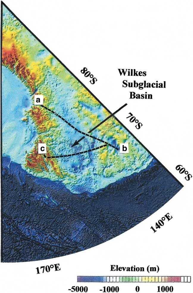
Fig. 1 BEDMAP2 map showing the Victoria Land Traverse route from a. the head of the Skelton Glacier at 78°00.0′S, 154°02.0′E, north-westward across the Victoria Land Plateau to b. 71°07.8′S, 139°11.0′E, and eastward to c. the Transantarctic Mountains at 72°15.1′S, 160°08.0′E (Weihaupt Reference Weihaupt1961, Weihaupt et al. Reference Weihaupt, Stuart, van der Hoeven, Lorius and Smith2012, Fretwell et al. Reference Fretwell, Pritchard and Vaughan2013).
Since its discovery, interest has been heightened in the relationships between the WSB, the Transantarctic Mountains (TAM) and the Ross Sea rift (RSR). The WSB in particular has been the subject of numerous investigations because of its enigmatic character (Armadillo et al. Reference Armadillo, Bozzo, Caneva, Manzella and Ranieri2007, Ferraccioli et al. Reference Ferraccioli, Armadillo, Jordan, Bozzo and Corr2009, Jordan et al. Reference Jordan, Ferraccioli, Armadillo and Bozzo2013). Inconsistency between gravity modelling, observed gravity, sedimentary basement geometry in the RSR basin, and their departure from traditional oceanic or continental crust (Karner et al. Reference Karner, Studinger and Bell2005), has led to interest in the continental complex of the WSB, TAM and RSR, and descriptions of the RSR and contiguous regions as ‘paradoxical’ (Karner et al. Reference Karner, Studinger and Bell2005). Stimulated by the International Polar Year 2007–08, several investigators have further described the WSB as poorly understood (Armadillo et al. Reference Armadillo, Bozzo, Caneva, Manzella and Ranieri2007), giving rise to differing explanations for its origin. These explanations have focused on the morphology and geology of the basin, possible thermal and isostatic uplift, craton margin rifting, magmatism, crustal architecture, buried fault patterns, magnetic lithospheric lineaments, sedimentary basins and subglacial lakes. Not significantly included in these investigations are non-tectonic features and processes, such as the climatic history of East Antarctica, alternating glacial and interglacial episodes, ice sheet modelling and dynamics, glacial erosion, basin deposition, marine processes, sea level change and related landscape modelling.
The scientific importance of the WSB lies in the fact that its origin, structure and subsequent history may have implications for the origin, structure and history of the TAM, the RSR, the Gamburtsev Subglacial Mountains and the East Antarctic craton, and also the palaeoclimatic and glaciological history of Antarctica.
Geologic and geographic setting of the Wilkes Subglacial Basin
Magmatism occurred in the Jurassic period, and separation of East Antarctica from Australia began in the Cretaceous with complete separation occurring in the Oligocene. Uplift and formation of the TAM occurred in late Cretaceous, and large scale RSR sedimentation occurred in late Eocene-Neogene from denudation of the TAM, followed by Neogene volcanic activity (Karner et al. Reference Karner, Studinger and Bell2005). Whereas the ages of many of the lithospheric features in the WSB proper are not known because of the overlying continental ice sheet, geophysical investigations reveal aeromagnetic lineaments, aeromagnetic buried fault patterns, rifting, back-arc structures, sedimentary basins, subglacial lakes, water-saturated sediments and subglacial topographic features. Seismic and gravity surveys (Weihaupt et al. Reference Weihaupt, Stuart, van der Hoeven, Lorius and Smith2012) revealed the subglacial topographic structure of the WSB for the first time (Fig. 2). These profiles, when referred to one another, showed a continental scale basin that slopes from near the South Pole northward to the coast of the Southern Ocean.
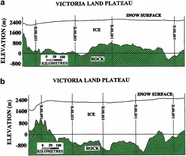
Fig. 2 Seismic-gravity profiles of the a. south leg and b. north leg of the Victoria Land Traverse (see Fig. 1) depicting the subglacial topography and the decrease in elevation of Wilkes Subglacial Basin from inland north toward the Southern Ocean (Weihaupt Reference Weihaupt1961, Weihaupt et al. Reference Weihaupt, Stuart, van der Hoeven, Lorius and Smith2012).
Although comparatively few geophysical investigations were conducted in the region of the WSB in the period 1960–2000, recent aerial surveys confirm the seismic and gravity findings of 1959–60, and the topography and dimensions of the basin (Fig. 3). These surveys include airborne radio echo-sounding of subglacial topography (Fretwell et al. Reference Fretwell, Pritchard and Vaughan2013) and airborne geophysical surveys revealing sub-ice geology (ten Brink et al. Reference Ten Brink, Hackney, Bannister, Stern and Makovsky1997, Studinger et al. Reference Studinger, Bell, Buck, Karner and Blankenship2004). Aeromagnetic surveys, providing valuable information about subglacial topography and crustal structure, reveal magnetic anomalies in the WSB lithosphere (Studinger et al. Reference Studinger, Bell, Buck, Karner and Blankenship2004), faulting along the margins of the WSB (Armadillo et al. Reference Armadillo, Bozzo, Caneva, Manzella and Ranieri2007), deep and shallow geophysical structures (Armadillo et al. Reference Armadillo, Bozzo, Caneva, Manzella and Ranieri2007), and subglacial structural lineaments (Ferraccioli et al. Reference Ferraccioli, Armadillo, Jordan, Bozzo and Corr2009). Of special interest is the BEDMAP work of Lythe et al. (2001) delineating the subglacial configuration of the WSB (Fig. 3a). This work is supplemented by that of Bamber et al. (Reference Bamber, Vaughan and Joughin2000) (Fig. 3b), as are aeromagnetic surveys of Ferraccioli et al. (Reference Ferraccioli, Armadillo, Jordan, Bozzo and Corr2009) (Fig. 3c) that improve and expand upon the geology, topography and configuration of the WSB. This work, now further enhanced by Fretwell et al. (Reference Fretwell, Pritchard and Vaughan2013) (Fig. 1), also emphasizes the importance of the elevation of the WSB relative to sea level, and the potential of sea level fluctuation and ocean invasion of the WSB lowland (Fig. 4a).
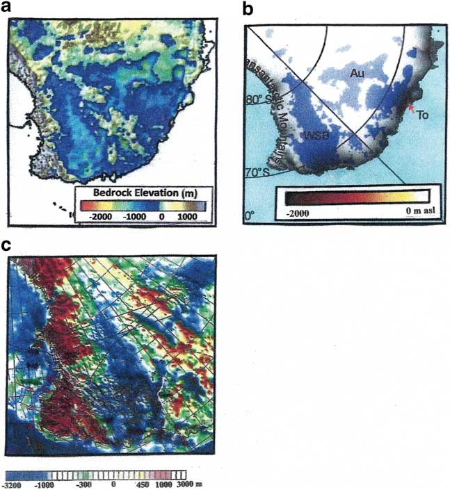
Fig. 3 Recent surveys conducted in East Antarctica now confirm the spatial dimensions, depth and general configuration of the Wilkes Subglacial Basin. a. BEDMAP1 radio-echo sounding (Lythe et al. 2001, Le Brocq et al. Reference Le Brocq, Hubbard, Bentley and Bamber2008). b. Continental ice sheet flow studies (Bamber et al. Reference Bamber, Vaughan and Joughin2000). c. Airborne survey (Ferraccioli et al. Reference Ferraccioli, Armadillo, Jordan, Bozzo and Corr2009).
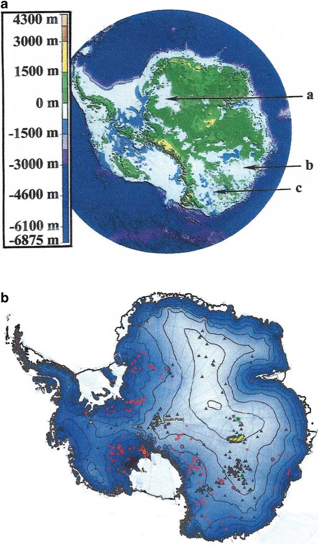
Fig. 4 a. Topography and bathymetry of the Antarctic continent showing relief and elevations above and below sea level in the a) Dronning Maude Land subglacial basin, b) Aurora Subglacial Basin, and c) Wilkes Subglacial Basin (Lythe et al. 2001, Cafarella et al. Reference Cafarella, Urbini, Bianchi, Zirizzotti, Tabacco and Forieri2006). b. The fourth inventory of subglacial lakes in Antarctica (courtesy M. Siegert). The red-circle lakes have been identified by ICESat surface uplift events and the black-triangle lakes have been detected by radio-echo sounding, the ice surface contour interval is 500 m (Wright & Siegert Reference Wright and Siegert2012).
Hypotheses of origin
The size of the WSB implies that its origin is due to large scale geologic processes operating on a continental or sub-continental scale. The initial hypotheses of origin have focused on lithospheric flexure (ten Brink et al. Reference Ten Brink, Hackney, Bannister, Stern and Makovsky1997), the WSB comprising thick continental crust and the ‘low’ of a lithospheric flexure that contrasts with the TAM as the flexural ‘high’ driven by extension within the RSR. Coupling of the WSB and the RSR to the central uplift of the TAM, and the differential flexural rigidity of thicker East Antarctica crust and the thinner Ross embayment are interpreted as reflecting contrasting thermal ages and geotherms of the two provinces. The TAM, the boundary between East and West Antarctica, has been described as divergent (ten Brink et al. Reference Ten Brink, Hackney, Bannister, Stern and Makovsky1997), with the WSB to the west of the TAM depressed 1 km below sea level and the Victoria Land basin to the east of the TAM as an area of extension in which 4–5 km of Cenozoic sediments have accumulated. This model, augmented by the isostatic effects of erosion and mass loss combined with thermal uplift of the TAM, is offered in support of hypothetical rifting reminiscent of foreland basins, ‘though remaining poorly understood’ (ten Brink et al. Reference Ten Brink, Hackney, Bannister, Stern and Makovsky1997).
Since these investigations, gravity modelling (Jordan et al. Reference Jordan, Ferraccioli, Armadillo and Bozzo2013) has revealed East Antarctic crustal thickness to be less than that predicted by the flexural model and c. 15 km less than that of the TAM. Studinger et al. (Reference Studinger, Bell, Buck, Karner and Blankenship2004) report a crustal thickness of c. 31 km, and sedimentary infill of less than 1 km in basins of the WSB, leading to the belief that the WSB contains a former broad back-arc basin and fold-and-thrust belts and craterform topography (Ferraccioli et al. Reference Ferraccioli, Armadillo, Jordan, Bozzo and Corr2009, Weihaupt et al. Reference Weihaupt, Rice and van der Hoeven2010). The large volumes of Jurassic tholeites imaged in the WSB and intruded and extruded over Beacon sediments, and graben-like features with up to 1.5 km sedimentary infill in the central basins suggest a rift setting (Ferraccioli et al. Reference Ferraccioli, Armadillo, Jordan, Bozzo and Corr2009), again instead of the flexural model.
The most recent data, from Jordan et al. (Reference Jordan, Ferraccioli, Armadillo and Bozzo2013), present aeromagnetic and aerogravity data from northern WSB in the vicinity of separation of the East Antarctic craton from south-eastern Australia. These data confirm a crustal thickness of 30–35 km, some 5–10 km thinner than under the TAM, and some 15 km thinner than postulated by flexural models for the southern WSB, and support the belief that inherited tectonic structures controlled the location of the WSB. Isostatic anomalies reveal tectonic structures along the eastern and western flanks of the WSB that appear to have controlled the location of the basin, suggesting that the WSB may be imposed on a back-arc region adjacent to the East Antarctic craton, that there may have been Jurassic to Cretaceous lithospheric extension prior to break-up from Australia (Escutia et al. Reference Escutia, De Santis, Donda, Dunbar, Cooper, Brancolini and Eittreim2005), and that Cenozoic glacial erosion may be a significant factor in thinning the northern Victoria Land crust (Thomson et al. Reference Thomson, Reiners, Hemming and Gehrels2013). Gravity and magnetic modelling favour a ‘broad extension (of the crust) beneath the enigmatic basin’ and suggest further that although the basin may be a ‘component of a flexural triad’, involving the WSB, the TAM and the RSR, the WSB is neither a flexural depression, a continental rift, nor extended crustal terrain (Armadillo et al. Reference Armadillo, Bozzo, Caneva, Manzella and Ranieri2007)! While emphasizing the complexity of the WSB, these several investigators conclude that thermal and uplift hypotheses are difficult to reconcile with the aerogravity data, pointing out that a reassessment of existing hypotheses is needed.
Given the enigmatic character of the WSB, and the uncertainty about its origin and geologic history, three alternative hypotheses remain: i) the WSB is a combination of tectonic processes that are not as yet fully understood nor elucidated, ii) the WSB is a consequence of large scale erosional or depositional events, or iii) it is a consequence of both. The evidence to date suggests the latter, that the WSB is the result primarily of tectonic processes and that post-tectonic processes have had a significant impact on the geology and configuration of the basin (Bamber et al. Reference Bamber, Vaughan and Joughin2000, Jordan et al. Reference Jordan, Ferraccioli, Armadillo and Bozzo2013). Erosional and depositional processes, acting independently or in concert, have the potential to explain much about the size, shape and subglacial topographic configuration of the WSB. The processes that suggest themselves are glacial and marine erosion and deposition subsequent to tectonism.
Post-tectonic processes
The ‘highly contentious stability’ of the continental ice sheet overlying the WSB (Ferraccioli et al. Reference Ferraccioli, Armadillo, Jordan, Bozzo and Corr2009), emphasizes not only its potential for the ice sheet having influenced the configuration of the WSB, but as well as its potential for collapse. Glacial erosion, dynamic and actively down-cutting, operates over comparatively short geological durations. Glacier and continental ice sheet movements have the capacity to substantially erode the subglacial surface (Pattyn Reference Pattyn2010) and are always accompanied by deposition. Long-term glacial erosion (normal ice sheet flow) and short-term glacial erosion (ice streams and glacial surge) may be augmented by the presence of water at the base of the ice mass (Rignot et al. Reference Rignot, Mouginot and Scheuchl2011). While the exact mechanisms of ice sheet dynamics are not yet known (Rignot et al. Reference Rignot, Mouginot and Scheuchl2011), the presence of water plays a crucial role in ice sheet stability (Llubes et al. Reference Llubes, Lanseau and Remy2006), and friction at the basal interface of an ice sheet plays a pivotal role in controlling ice dynamics. Hughes (Reference Hughes2009) points out that the glacial erosion and evolution of landscapes under the ice occurs only where the bed is not frozen, and basal water production may be a function in part of temperature increase from geothermal heat (Pattyn Reference Pattyn2010), the heat of friction, or heat introduced with increased water saturation levels. Siegert et al. (Reference Siegert, Taylor and Payne2005), on the basis of radar survey, identifies subglacial lakes and water-saturated basal sediment beneath the East Antarctic ice sheet that favour continental ice sheet movement. Wright & Siegert (Reference Wright and Siegert2012) identify 379 such subglacial lakes (Fig. 4b), most of which lie in East Antarctica, and lie prominently in groupings in the WSB. The water-related conditions at the base of the East Antarctic continental ice sheet appear therefore to be abundantly present, and correlate with the onset of enhanced glacial flow (Wright & Siegert Reference Wright and Siegert2012). Similarly, water-saturated basal sediments exist in the WSB, also favouring glacial processes in influencing the morphology of the WSB. Smooth subglacial topography noted in the WSB (Wright & Siegert Reference Wright and Siegert2012) reduces basal friction and promotes rapid ice sheet flow.
The triangular shape of the WSB, the non-equidimensional morphology with non-parallel boundaries, is uncharacteristic of a tectonic origin (Studinger et al. Reference Studinger, Bell, Buck, Karner and Blankenship2004), suggesting that a non-tectonic mechanism is needed to explain the triangular shape of the basin. Because continental ice sheet velocities and ice volumes downstream tend to be much greater than those upstream, downstream erosion tends to be greater than erosion upstream. In particular, the additive volumes of ice accumulating downstream are greater than those upstream, and the downstream swatches of moving ice are wider than those upstream. The anticipated subglacial erosion is therefore coincident with a triangular configuration, with an upstream apex and a downstream base much like the triangular shape of the WSB. Jordan et al. (Reference Jordan, Ferraccioli, Armadillo and Bozzo2013), on the other hand, suggest that both margins of the WSB are structurally controlled, and that the triangular shape results from the intersection of these two structures.
While major uncertainties exist about basal conditions, including the temperature field and geothermal heat flow (Pattyn Reference Pattyn2010), ice streams in the continental ice sheet are less likely than continental ice sheet advance or recession per se to create significant changes in the large scale configuration of the WSB, or in its subglacial topography. Jamieson et al. (Reference Jamieson, Sugden and Hulton2010) note that interior continental erosion prior to emplacement of the East Antarctic continental ice sheet is likely to have been less that 200 m, much like that of the Laurentian and Scandinavian shields. In contrast, the early East Antarctic continental ice sheet is likely to have been dynamic, with ice flow concentrated along fixed ice streams (Thomson et al. Reference Thomson, Reiners, Hemming and Gehrels2013), with consequent selective erosion of the ‘ice-hidden’ landscape. Erosional down-cutting along the continental margins may have been as much as 2.8 km due to high erosion rates caused by steep thermal gradients in basal ice (Jamieson et al. Reference Jamieson, Sugden and Hulton2010), and Whitehead & Clift (Reference Whitehead and Clift2009) note that thickened elevated continental crust is subject to severe erosion. Ice streams may in fact respond to or affect not only the subglacial topography (Truffer & Echelmeyer Reference Truffer and Echelmeyer2003), but the overlying ice sheet as well. The development of ice streams within a continental ice sheet often transforms the surface of the ice (Bamber et al. Reference Bamber, Vaughan and Joughin2000), creating substantial crevassing and large blocks in the continental ice sheet (Truffer & Echelmayer 2003), which have been noted in the East Antarctic continental ice sheet in near coastal regions (Weihaupt et al. Reference Weihaupt, Stuart, van der Hoeven, Lorius and Smith2012). Capable of creating dramatic change over comparatively short intervals (Bamber et al. Reference Bamber, Vaughan and Joughin2000), ice streams may represent a hundred-fold increase in velocity (Jezek Reference Jezek2002), with the result that significant subglacial topographic effects are likely (Bianchi et al. Reference Bianchi, Cafarella, De Michelis, Forieri, Frezzotti, Tabacco and Zirizzotti2003). Not only are significant topographic reconfigurations possible, but Earth's continental crust may be significantly thinned by erosion (Whitehead & Clift Reference Whitehead and Clift2009), depending upon the rate and mass of glacier or ice sheet movement. The presence of ice streams in the WSB continental ice sheet, in the form of the Mertz and Ninnis glaciers, is another example of non-tectonic processes in the WSB that may have influenced its morphology. These observations make apparent the potential influence of climatic and sea level variations that may ultimately have impacted the configuration of the WSB.
Climate and sea level change
Subglacial topographic smoothness is generally greater when the bed is below sea level (Siegert et al. Reference Siegert, Taylor and Payne2005), as in the case of much of the WSB. This basin is the only extensive subglacial region in East Antarctica that descends below -500 m elevation (Fig. 4a) (Fretwell et al. Reference Fretwell, Pritchard and Vaughan2013), a consequence of the processes that formed the WSB and of the isostatic adjustment that has accompanied lithospheric depression due to the load of the continental ice sheet. Should all or a portion of the East Antarctic continental ice sheet collapse, the ocean would invade the lowland, although isostatic rebound would eventually expel some portion of the sea from the WSB. Flooding from the Southern Ocean would be accompanied by marine erosion and deposition, and the WSB somewhat reconfigured. It should be noted that such sediments may be draped over features created by earlier tectonic events, thus modifying pre-existing subglacial topography.
WSB topography is ‘extremely smooth’ (Siegert 2005) compared to adjacent regions, also implying a role for sea level rise and marine deposition. The record of global sea level variations is coincident with the record of ice sheet growth and decline (Miller et al. Reference Miller, Mountain, Wright and Browning2011), further substantiating the likely influence of marine processes on the WSB. Global sea level fluctuations, responses to variations in continental ice sheet volumes, are therefore responses also to global climatic change.
Global climatic change, to a first approximation, is a function of solar activity and Earth's orbital parameters, i.e. orbital eccentricity, obliquity and precession. Each of these fundamental drivers of climate change affects the distribution and amount of incident solar radiation, enabling predictable pacing of the planet's climate in geological time, including potential past glacial activity and sea level fluctuations. The effects of plate tectonics are superimposed upon orbitally-induced variations, and include the effects of continental geography, oceanic gateways, bathymetry and volcanic greenhouse gas concentrations. These give rise to climatic episodes on million-year timescales, collectively giving rise to extremes of expansive warmth with ice-free poles and to extremes of cold with massive ice sheets at the poles (Zachos et al. Reference Zachos, Pagani, Sloan, Thomas and Billups2001, Mayewski et al. Reference Mayewski, Maasch, Yan, Kang, Meyerson, Sneed, Kaspari, Dixon, Osterberg, Morgan, van Ommen and Curran2006), including ‘extremes in Antarctic ice-volume and temperature’ (Zachos et al. Reference Zachos, Flower and Paul1997). Considering that the total removal of the Antarctic continental ice sheet is equivalent to a 57 m rise in sea level, and the return of the continental ice sheet equivalent to similar declines in sea level after ocean incursion, recession and isostatic response, the timing of glacial events is critical to unravelling the times of both ice sheet and marine modification of the WSB.
Whereas the Pleistocene and Holocene have seen some of the lowest sea levels in the Phanerozoic, global sea level increases of some 100 m or more occurred before the ice sheets developed, with specific increases of 250 m (53 Ma), 200 m (40 Ma) and 65 m (33 Ma). Significant global climatic cooling and the onset of glaciation in East Antarctica occurred in late Eocene (Escutia et al. Reference Escutia, De Santis, Donda, Dunbar, Cooper, Brancolini and Eittreim2005). The first significant permanent ice sheet appeared, therefore, c. 34 Ma. The latter part of the Oligocene then saw a warming trend that reduced the extent of the Antarctic continental ice sheet and increased global sea level between 27 Ma and 26 Ma, i.e. 45 m (26 Ma), 45 m (20 Ma) and 25 m (15 Ma), peaking in a mid-Miocene climatic optimum between 17 Ma and 15 Ma. This was followed in mid-Miocene (14–10 Ma) by a transition from a dynamic ice sheet regime to one of oscillatory ice sheets (Escutia et al. Reference Escutia, De Santis, Donda, Dunbar, Cooper, Brancolini and Eittreim2005), then by a gradual cooling and re-establishment of a major Antarctic ice sheet by 10 Ma and a consequent decrease in global sea level, and by sea level increases of 45 m (9 Ma) and 50 m (6 Ma) (Mosbrugger et al. Reference Mosbrugger, Utescher and Dilcher2005, Miller et al. Reference Miller, Mountain, Wright and Browning2011). This latter ice sheet persisted until early Pliocene and the appearance of a mild warming trend 3.2 Ma.
At least thirty continental ice sheet expansions to the coast and retreats to East Antarctica's subglacial highlands occurred after 34 Ma. Since 34 Ma, shorter intervals of major ice sheet growth and decline were superimposed upon these longer term trends at 35.0–31.0 Ma, 24.5–20.5 Ma, 16.5–12.5 Ma and 4.0–0.0 Ma, recording the frequency of alternating erosional and depositional events in the WSB, and the presence at times of ‘extremely dynamic’ ice sheets (Zachos et al. Reference Zachos, Pagani, Sloan, Thomas and Billups2001, Escutia et al. Reference Escutia, De Santis, Donda, Dunbar, Cooper, Brancolini and Eittreim2005). Likely modification of the tectonically-structured basin is, therefore, abundantly evident in the late Cenozoic climatic, glacial and sea level record.
These observations are also consistent with WSB ice sheet history derived from Earth's orbital geometry (Zachos et al. Reference Zachos, Pagani, Sloan, Thomas and Billups2001, Huybers Reference Huybers2009), from the record revealed by continental margin sediments (Escutia et al. Reference Escutia, De Santis, Donda, Dunbar, Cooper, Brancolini and Eittreim2005), oxygen isotope analyses (Mosbrugger et al. Reference Mosbrugger, Utescher and Dilcher2005), atmospheric carbon dioxide concentrations (Lüthi et al. Reference Lüthi, Le Floch, Bereiter, Blunier, Barnola, Siegenthaler, Raynaud, Jouzel, Fischer, Kawamura and Stocker2008, Schmitt et al. Reference Schmitt, Schneider, Elsig, Leuenberger, Lourantou, Chappellaz, Köhler, Joos, Stocker, Leuenberger and Fischer2012), atmospheric temperature (Escutia et al. Reference Escutia, De Santis, Donda, Dunbar, Cooper, Brancolini and Eittreim2005), palaeoclimate (Zachos et al. Reference Zachos, Pagani, Sloan, Thomas and Billups2001, Tripati et al. Reference Tripati, Roberts and Eagle2009), ice sheet advance and decline, and sea level fluctuations (Miller et al. Reference Miller, Mountain, Wright and Browning2011). We conclude that the location and fundamental configuration of the basin is a function of tectonic activity, and that post-tectonic processes have had a substantial role in the present configuration of the Wilkes Subglacial Basin.
Acknowledgements
We wish to thank colleagues who were members of the Victoria Land Traverse team, and who helped assure the success of that exploration. Among these are Alfred W. Stuart, William M. Smith, Arnold J. Heine, Louis Roberts, Alfred Taylor, Thomas Baldwin and Warren Jackman. We thank in particular readers of the paper, A. Vaughan, T. Hughes and T. Jordan who made very helpful suggestions, and who demonstrated a very professional and sincere willingness to be of assistance in the publication of this paper. We also wish to thank colleagues who kindly provided material for the figures, J. Bamber, L. Cafarella, H. Corr, F. Ferraccioli, P. Fretwell, A. Le Brocq and M. Siegert. Finally, we wish to thank the United States National Science Foundation for support of the original field investigations, the University of Colorado Denver, Delft University of Technology and the Laboratoire de Glaciologie et Géophysique de l'Environnement for resource and administrative support. We also thank the reviewers for their comments on the manuscript.


