


Introduction
Till deposits in the McMurdo Dry Valleys provide a terrestrial record of palaeoclimate in Antarctica. At high elevations (>1000 m) these deposits indicate that little has changed in the hyperarid, polar climate for the last 12.4 Myr (Lewis et al. Reference Lewis, Marchant, Ashworth, Hedena, Hemming, Johnson, Leng, Machlus, Newton, Raine, Willenbring, Williams and Wolfe2008, Lewis & Ashworth Reference Lewis and Ashworth2015). However, at low elevations (<500 m) numerous till deposits can be related to Quaternary glaciations, while core records from ANDRILL (McKay et al. Reference McKay, Browne, Carter, Cowan, Dunbar, Krissek, Naish, Powell, Reed, Talarico and Wilch2009) and small alluvial fans in the Dry Valleys (Ramsey et al. 2014 unpublished abstract) show evidence of periodic warmth since the Miocene. Deciphering this terrestrial record is difficult because of variations produced by elevation and difficulty in dating till deposits with tephra and cosmogenic nuclides.
The palaeoclimatic picture of the Dry Valleys is not complete without understanding the granite erratics at high elevation tills found in the Convoy and Asgaard ranges (Claridge & Campbell Reference Claridge and Campbell2002), in Arena and Beacon valleys (Linkletter et al. Reference Linkletter, Bockheim and Ugolini1973, Marchant et al. Reference Marchant, Denton and Swisher1993) and at Table Mountain (Ivy-Ochs et al. Reference Ivy-Ochs, Schluchter, Kubik, Dittrich-Hannen and Beer1995) (Figs 1 & 2). The problem in these areas is that granite bedrock presently crops out topographically below and glacially downstream from most of these erratics. In Beacon Valley, the significance of the erratics has become more important since Potter & Wilson (Reference Potter and Wilson1983) first reported buried ice, which Sugden et al. (Reference Sugden, Marchant, Potter, Souchez, Denton, Swisher and Tison1995) dated as >8 Ma in the central portion of the valley suggesting it was the source of the granite erratics.
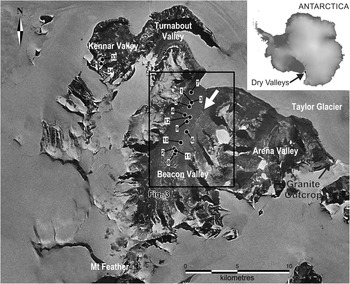
Fig. 1 Map shows location of Beacon Valley and adjacent valleys in the McMurdo Dry Valleys. Numbers (1–12, 33, 34) show the locations of granitic erratics analysed in Table I. The white arrow shows the ancient lateral moraine (see Fig. 4a) on the south-east flank of the Beacon Valley. Box indicates study area shown in Fig. 3. Base map from the United States Antarctic Resource Center (2003, http://usarc.usgs.gov/).

Fig. 2 Structure contours shown for the Kukri Erosion Surface (KES) in the Dry Valley area. Granite bedrock lies below this surface, which dips 1–3° to the west–north-west. Green areas show where the KES dips below the present ground and ice surfaces. Grey areas show where the KES lies above ground and ice surfaces. Data from Cox et al. (Reference Cox, Turnbull, Isaac, Townsend and Smith2012) were created using topographical survey data from the 1960s to 2000s by the United States Geological Survey and Land Information New Zealand.
In the Dry Valleys, granite basement crops out below the Kukri Erosion Surface (KES), which is at the base of the Beacon Supergroup (McKelvey et al. Reference McKelvey, Webb and Kohn1977) (Fig. 2). A number of studies (Linkletter et al. Reference Linkletter, Bockheim and Ugolini1973, Lewis Reference Lewis2000, Marchant et al. Reference Marchant, Lewis, Phillips, Moore, Souchez, Denton, Sugden, Potter and Landis2002, Bockheim Reference Bockheim2007) have reconstructed past glacial episodes in Beacon Valley, but they have not resolved the problems associated with the source of the granite erratics. Granite bedrock is absent within Beacon Valley and its nearest exposure is 10 km downstream (east) of the valley entrance (Fig. 1). While granite undoubtedly lies ~50 m below the Taylor Glacier at the mouth of Beacon Valley, none is subaerially exposed upstream (west) of the valley (McElroy & Rose Reference McElroy and Rose1987). Granite erratics have been reported in high elevations of Arena Valley (Marchant et al. Reference Marchant, Denton and Swisher1993), but they are absent in Turnabout and Kennar valleys, which are adjacent and west of Beacon Valley (Fig. 1). Given these constraints, it is difficult to understand how the present cold-based, flow regime of the Taylor Glacier, even during periods of known ice expansion in the last 4.4 Myr (Marchant et al. Reference Marchant, Denton and Swisher1993, Wilch et al. Reference Wilch, Denton, Lux and McIntosh1993) could deliver granite into Beacon Valley. This suggests that the granite erratics must have been emplaced by a completely different ice regime than exists at present.
The aim of this paper is to use lead (Pb) isotopes to fingerprint and help identify the bedrock source of the granite erratics. The abundance of granite erratics in the valley is quantified to determine the extent of their emplacement. The paper also explores the problems associated with the emplacement of these erratics in Beacon Valley. Where the granite erratics came from and how they were transported, will help determine palaeoflow directions at the time of emplacement and hence the glacial history of the Dry Valleys.
Background
Linkletter et al. (Reference Linkletter, Bockheim and Ugolini1973) attempted some of the first glacial reconstructions of Beacon Valley and used the granite erratics to identify till deposits. Webb (Reference Webb1974) proposed two possibilities for the source of the granite. He suggested that although a crystalline basement source was initially an appealing explanation, the absence of exposed basement granite in Beacon Valley would preclude this idea. His alternative explanation was that the granite derived from coarse, glacial diamicts of the Metschel Tillite, which contains erratics of gneiss, granite and sandstone, and crops out in Beacon and Kennar valleys (Fig. 1). If these diamicts were the source, then the granite erratics could have been locally derived rather than transported from a distant source into Beacon Valley by the Taylor Glacier. This explanation would eliminate the need for ‘up stream’ transport of the erratics.
Marchant et al. (Reference Marchant, Denton and Swisher1993) reported granite erratics in lower and central Arena Valley. They associated them with the Quartermain I (11.6–4.4 Ma) and Quartermain II tills (>11.3 Ma), and they believed that both tills represented an expansion of the Taylor Glacier. Lewis (Reference Lewis2000), Potter et al. (unpublished abstract) and Sugden et al. (Reference Sugden, Marchant, Potter, Souchez, Denton, Swisher and Tison1995) mapped the extent of the granite-bearing till, which appears to overlie parts of the buried ice in the centre of Beacon Valley, and referred to it as the ‘Granite Drift’ (Fig. 3). In their model, the granite and ice were externally sourced by an expansion of the Taylor Glacier before 8 Ma. They suggested that the Granite Drift evolved from the underlying ice, which has sublimated for a minimum of eight million years to produce a coarse-grained till on the surface. This model was further supported by Marchant et al. (Reference Marchant, Lewis, Phillips, Moore, Souchez, Denton, Sugden, Potter and Landis2002), who used cosmogenic 3He in depth profiles of the Granite Drift as evidence for a sublimation till. Their results strengthen the hypothesis of Sugden et al. (Reference Sugden, Marchant, Potter, Souchez, Denton, Swisher and Tison1995) that Beacon Valley has experienced relatively little modification under polar conditions since the late Miocene.

Fig. 3 Maps show clast abundance and composition of drift deposits in Beacon Valley. Dashed line is the extent of the Granite Drift as mapped by Lewis (Reference Lewis2000). a. Contours (5% intervals) show the percent abundance of granite erratics as counted from 60 transects (see text for details). Red star shows location of a 20 m core into the ancient buried ice. b.–d. Colour composition maps show percent of the clast types (granite, sandstone and dolerite) in the drift deposits. Colour shades of percent clasts are the same for each map.
Claridge & Campbell (Reference Claridge and Campbell2002) discussed the presence of granite erratics at numerous high elevation locations of the Dry Valleys. Rather than the eastward flowing ice of the present glaciers, Claridge & Campbell (Reference Claridge and Campbell2002) proposed that up-valley or north-west flowing ice deposited the erratics as the result of a grounded and much expanded Ross Ice Shelf, which reached far up the valleys. The direction of this ice flow was analogous to the Ross Sea glaciations in the Quaternary (Claridge & Campbell Reference Claridge and Campbell2002).
In our study, four stable isotopes of lead (204Pb, 206Pb, 207Pb, 208Pb) are measured on alkali feldspar minerals in the granite erratics to estimate their initial isotopic compositions. Pb isotopes, traditionally used for dating, can also be used to differentiate between magmatic sources of igneous complexes, as each magma will have a distinct Pb isotopic composition, which is inherited by the resulting crust (Connelly & Thrane Reference Connelly and Thrane2005). This is possible because alkali feldspars do not incorporate U and Th into their mineral chemistry. With no additional input of radiogenic Pb from the decay of U or Th, the Pb isotopic composition of the alkali feldspars is a measure of the initial Pb isotopic composition of the magma at the time of crystallization. The Pb isotopic composition of the Beacon Valley granite erratics can be compared with those from potential source rocks to establish a genetic relationship.
Methods
Fieldwork and samples
To constrain distribution of granite, sandstone and dolerite clasts, 60 random sites were selected on the drift in Beacon Valley. At each site, clast lithology was record directly below a 50 m tape in 1 m sections. Clasts were defined as >0.5 cm in average diameter, and anything smaller was not identifiable and recorded as sand. If granite erratics were present near the transect but not counted within any 1 m section, they were recorded as ‘trace’ granite. Different granite erratics were collected along the transect, and from hand samples, we described their grain size and mineralogy. Three distinct granite types were found and 12 representative erratics were selected for isotopic analysis (Table I). Variations in the mineralogy of the sandstone and dolerite clasts were observed but not recorded.
Table I Pb isotopic composition of samples analysed in this study.

Isotopic values for each sample are an average of three analyses on three different feldspars.
BV=Beacon Valley granite clasts, MT=Metschel Tillite, P=GNS Petlab rock collection, V=Victoria Valley and W=Wright Valley granite outcrops, 31660 & 31650=Victoria University of Wellington rock collection.
See text for definitions of clast type (G1, G2, G3) and pluton type (DV1a, DV1b, DV2).
na=not applicable.
To compare the erratics against possible source rocks, 20 samples were selected from granitic plutons, which are part of the Granite Harbour Intrusive Complex in the Dry Valleys (Table I). These samples were collected during fieldwork and from existing rock collections. Samples of the Metschel Tillite were taken in Kennar Valley, adjacent to Beacon Valley (Fig. 2). Although this tillite contains numerous granitic clasts, it was difficult to remove large pieces owing to the weathered nature of the clasts. These samples were epoxied and thin sectioned to examine the degree of weathering in the feldspars.
A map of the KES was made from a digital elevation model (DEM), which was generated at 40 m grid spacings from 50 m topographical contours. Mapped locations of the KES were collected as a series of XY point data, with an elevation Z assigned from the DEM grid. A grid of the KES was then interpolated from the XYZ point data and displayed as 100 m contours (see Cox et al. Reference Cox, Turnbull, Isaac, Townsend and Smith2012 fig. 22). All interpolations were completed in ArcGIS, using the Topo to Raster (for DEM) and Natural Neighbor (for KES) algorithms.
Beacon Valley ice samples
In 1998, Sletten (unpublished) cored 20 m of the buried ice beneath the Beacon Valley till, in the centre of the valley (red star, Fig. 3a). Unfortunately, this core melted in storage, but sediment from the melted portion was collected at ~1 m intervals for the length of the core (Sletten, personal communication 2004). These samples were combined, homogenized and split. The split sample was impregnated with epoxy and thin sectioned. Five hundred point counts were made of the thin section to identify the mineralogy and lithologies present in the sediment.
Isotopic analyses
Pb isotope ratios were determined on alkali feldspars by laser ablation, multiple-collector inductively coupled plasma, mass spectrometry (LA-MC-ICP-MS). Alkali feldspar has extremely low U/Pb and Th/Pb ratios meaning that the measured ratios record the initial Pb isotopic composition of the igneous samples. All samples were cut into rock slabs (2 cm2 by 0.5 cm thick) to ensure that numerous alkali feldspar crystals were exposed. In total, 34 samples were analysed with three analyses made on different feldspars in each sample (Table I). An external glass standard, NIST612, was used to correct raw Pb isotope ratios for instrumental mass fractionation by normalizing measured values to the reference values for this standard (Baker et al. Reference Baker, Peate, Waight and Meyzen2004). The standard was analysed before the first and after the third analysis for each sample, and was performed under the same ablation and instrumental conditions as the unknown samples.
Quoted errors for all the samples are internal 2 standard errors (2 s.e.). The most precise measurements are for the 207Pb/206Pb and 208Pb/206Pb ratios with average errors (2 s.e.) of ±0.0015 and ±0.00064, respectively. Because 204Pb is the least abundant of the four Pb isotopes, errors associated with 20xPb/204Pb ratios are greater than those without the 204Pb isotope and average errors (2 s.e.) for 206Pb/204Pb, 207Pb/204Pb and 208Pb/204Pb are±0.031,±0.026 and±0.070, respectively.
The presence of mineral inclusions in the alkali feldspars that were not exposed on the surface of the prepared rock slabs can, if ablated, produce more radiogenic Pb compositions than the alkali feldspar as they are potentially enriched in U and Th (e.g. apatite). Each analysis was screened for the presence of transient radiogenic Pb isotopic signatures and rejected if present. For example, three granite clast samples (BV-G1-T9, BV-G3-5 and BV-G4-2A) were excluded from interpretation, as all displayed radiogenic Pb values, particularly for the 208Pb/204Pb ratio. In addition, two samples (BV-G3-5 and P-49909) were analysed twice on the same scan line to test for anthropogenic contamination. Little variation of Pb isotopic composition in the second analysis of these samples indicated that no anthropogenic Pb was added to the surface of the rock slabs and alkali feldspars during sample preparation and analysis.
Results
Granite erratics in Beacon Valley
Granite erratics mapped on and around the floor of Beacon Valley range in size from small pebbles (>0.5 cm) to boulders (< 4 m) (Fig. 3). The highest concentration (up to 26%) of the erratics lies in a north–south elongate area (~0.5 km by 3 km) on the eastern flank of the valley and 100–200 m above the valley floor (Figs 1 & 4a). The erratics are present in the three eastern tributary valleys, but concentrations decrease southward along Beacon Valley. Their highest elevation is ~1850 m (a.s.l.), ~2 km south of West Beacon peak, and their southernmost extent is ~1350 m (a.s.l.) at the entrance to Farnell Valley. Although granitic clasts were found embedded in the upper surface of the massive ice, neither granitic fragments nor feldspars associated with granite were found in the cuttings from the 20 m ice core of the buried ice.

Fig. 4.a Large lateral moraine 3–4 m high on the south-east flank of Beacon Valley (white arrow in Fig. 1 shows location). b. The 4 m long boulder of granite type G4. c. Weathered granite clasts in Metschel Tillite in Kennar Valley. d. Granite erratic type G1. e. Granite erratic type G3. f. Granite erratic type G4. Ellipses show areas of laser ablation on feldspar minerals.
Three types of granite erratics (G1, G3, G4) were identified in the field and vary spatially throughout the exposed till (Table II, Fig. 4; for clast counts see Table S1 found at http://dx.doi.org/10.1017/S0954102017000013). Fine-grained, light felsic (G1) erratics are the most abundant (94% of all granite erratics) and widely distributed (Fig. 4d). Medium grained granodiorite (G3) erratics are scarce (5.5% of all granite erratics) and occur mainly as small pebbles (Fig. 4e). Coarse-grained, pink granite (G4) erratics are rare and were found only in four locations as mainly large (2–4 m) boulders (Fig. 4b & f). Because granite types G3 and G4 were scarce, representative samples of these were collected from either side of the transect line. No recognizable patterns in distribution of the three types of erratics were apparent from mapping clast abundance in the valley.
Table II Description, occurrence and correlation of granite clasts in Beacon Valley.

a Mineralogy is an average point count for four samples.
b Tentatively determined from trace element chemistry (see text and Fig. 4c).
In both Pb isotope plots (Fig. 5a & b), over half (more than seven samples) of the erratics lie within analytical error of the plutons. The granite clasts have a wide range of isotopic values, compared to that of the granite plutons. In general, the G4 erratics have smaller Pb isotopic variations than the G1 and G3 erratics.

Fig. 5 Plots show Pb isotope and geochemical compositions of granite erratics and granite suites from the Dry Valleys. Pb isotopic data (a. & b.) are presented in Table I, and geochemical data (c.) are from Allibone et al. (Reference Allibone, Cox and Smillie1993), Cox et al. (Reference Cox, Parkinson, Allibone and Cooper2000) and Williams (Reference Williams2006). c. Shows a possible correlation between granitic suites and clast types. Crosses in a. and b. show analytical error; analytical errors were not reported for the data in c.
The G4 erratics show distinct Pb isotopic variations from core to rim in the feldspar minerals. These variations are outside the average errors for each isotopic ratio, and this indicates that there is significant isotopic heterogeneity in the alkali feldspars. Most probably, this isotopic zoning is a primary magmatic feature indicating that the melt source for the magma changed throughout the time of crystallization. Unfortunately, this heterogeneity in the erratics precludes their correlation to an individual Dry Valley pluton. This problem cannot be solved by more measurements on either the erratics or the basement plutons.
Granite plutons in the Dry Valleys
The Dry Valley plutons trend NW–SE (Fig. 6). The largest is the Bonny pluton, which is ~100 km long and 25 km wide. Pb isotope data of the alkali feldspars of the granite pluton samples produce a generally consistent and small range of values (Table I Id. 13–32, Fig. 5a & b). The largest range of values was generated by the 208Pb/204Pb ratios (37.400 to 38.053), and consequently, they have the largest average error (0.56). The most precisely measured ratios, 207Pb/206Pb and 208Pb/206Pb, produced the narrowest range (0.8649 to 0.8765 and 2.0815 to 2.1329, respectively) and the smallest average errors (0.0181 and 0.0058, respectively).

Fig. 6 Map shows granite samples used in this study (numbers listed in Table I). These are superimposed on a simplified map of three petrological suites of granites as defined by Allibone et al. (Reference Allibone, Cox and Smillie1993) for Dry Valley plutons. Grey areas represent outcrop and white areas represent ice. The granitic suites are extrapolated only a short distance below the ice. Granite outcrop was not analysed but is considered to be part of the DV1a suite. Box indicates study area shown in Fig. 1.
Cox et al. (Reference Cox, Parkinson, Allibone and Cooper2000) measured Pb isotopes on whole rock samples of Dry Valley granites. A comparison of these whole rock analyses to the alkali feldspar samples used in our study, reveals distinctly higher 206Pb/204Pb values for the whole rock samples. This is expected because U in any mineral of the whole rock samples would decay and produce 206Pb over time, whereas the alkali feldspars do not contain U. Although different, these two Pb isotope datasets are internally coherent and support the fingerprinting method (see Fig. S1 found at http://dx.doi.org/10.1017/S0954102017000013).
Allibone et al. (Reference Allibone, Cox and Smillie1993) identified 15 major plutons and numerous dike swarms in the Dry Valleys region. Based on field relationships, geochemistry and age from a dataset of 66 samples, they divided these plutons into three general petrogenetic suites: Dry Valleys 1a (DV1a), Dry Valleys 1b (DV1b) and Dry Valleys 2 (DV2). Using Nd, Sr and Pb isotopes, Cox et al. (Reference Cox, Parkinson, Allibone and Cooper2000) confirmed these three geochemical suites and suggested that they evolved time-transgressively from distinct source rocks. This complex relationship between the suites is further exacerbated by cross contamination from crustal and mantle material. In their entirety, the geochemical parameters used by Allibone et al. (Reference Allibone, Cox and Smillie1993) and Cox et al. (Reference Cox, Parkinson, Allibone and Cooper2000) indicate three suites, but it is not possible to show distinct petrogenetic suites with a limited number of parameters. For example, the plot of Rb vs Nb + Y, used by Cox et al. (Reference Cox, Parkinson, Allibone and Cooper2000) to show distinct source rocks, produces significant overlap in the suites (Fig. 5c).
Metschel Tillite
Exposures of the Metschel Tillite are limited to areas around Beacon Valley. Stratigraphically, it is in the middle of the Beacon Supergroup and has an age between Carboniferous and Permian. In Kennar Valley, the Metschel Tillite occurs as a diamictite composed of sandstone, siltstone, gneiss and granite clasts set in a massive, silty green matrix (Fig. 4c). Clasts make up ~5% of the diamictite and maximum clast size is ~30 cm. Most of the clasts are heavily weathered and well cemented within the surrounding matrix. Petrological analysis shows that some of the minerals in the granite clasts have been replaced by clay. However, careful selection of alkali feldspar grains, prior to laser ablation, avoided most alterations and provided relatively consistent Pb isotopic values, which showed initial compositions.
Discussion
Source of erratics
Major and trace elements show a reasonable correlation between the three types of erratics and the three types of Dry Valley plutons. Of all the plots used by Williams (Reference Williams2006), the plot of Rb vs Nb + Y probably shows this relationship the best (Fig. 5c). Despite overlaps of the three plutons seen on this plot, granite clast types G1, G3 and G4 show a rough similarity to pluton types DV1b, DV1a and DV2, respectively. This correlation is tentative because of the small number of erratics measured and the variability in geochemical composition of the granite basements.
Granite clasts from the Metschel Tillite have elevated values of radiogenic Pb and never fall within error of either the values for the basement granites or the Beacon Valley granite clasts (Fig. 5a & b). Field observations also confirm the Metschel Tillite is an unlikely source for the Beacon Valley granite clasts. Clasts in the tillite are heavily weathered and small in size relative to the Beacon Valley clasts (maximum diameter 30 cm in the Metschel Tillite vs 4 m in the drift). The distinct isotopic composition of the Metschel Tillite clasts suggests they are not derived from the Dry Valley plutons. Based on estimates of palaeoflow direction for the time of deposition (Barrett Reference Barrett1981), the granite clasts of the Metschel Tillite may be related to the Dry Valley granite equivalents in central Victoria Land; the Wilson Terrane of Dry Valley plutons.
Granite erratics in Beacon Valley lie mostly within the boundaries of the Granite Drift as mapped by Lewis (Reference Lewis2000) and Sugden et al. (Reference Sugden, Marchant, Potter, Souchez, Denton, Swisher and Tison1995) (Fig. 3). The concentration pattern of the granite erratics in Beacon Valley gives little clue about their source. For example, one would expect their concentration to increase towards the Taylor Glacier if it were the source, but this is not the case. The greatest abundance of granite erratics is roughly associated with the prominent lateral moraine (white arrow in Fig. 1, Fig. 4a), which was mapped by Linkletter et al. (Reference Linkletter, Bockheim and Ugolini1973) and McKelvey & Webb (Reference McKelvey and Webb1959) on the eastern flank of Beacon Valley. The distribution of the granite erratics depends on: i) their distribution in the transporting ice, ii) flow directions of the transporting ice and iii) the sublimation rate of the transporting ice. Given that these parameters are largely unknown, the enigmatic pattern of granite clasts should not be surprising.
The abundance of the granite erratics also appears to be affected by the abundance of the two other major clast types, Ferrar Dolerite and Beacon Supergroup sandstones. Both dolerite and Beacon Supergroup crop out on all of the valley walls, and their abundance may simply be controlled by local erosion and topography. Different erosion rates of the major clast types may also affect the distribution patterns. To understand the effects of erosion and dilution, a 3D analysis of the till is necessary, whereas our traverse count only gives an approximation of 2D at the present surface (Table S1). In addition, it is not clear why so little granite exists on the west flanks of the valley where Linkletter et al. (Reference Linkletter, Bockheim and Ugolini1973) mapped old soils and till. However, this lack of granite erratics may be related to the significant difference in geomorphology between the west flank of Beacon Valley with steep rectilinear slopes and east flank with hanging valleys, which must relate back to when valley erosion was active.
The Pb isotopic data strongly suggest that the granite erratics in Beacon Valley derive from Dry Valley plutons. While these data cannot identify specific plutons, elemental data allow tentative correlation of the types of clasts to one of three granitic suits, which were defined by Allibone et al. (Reference Allibone, Cox and Smillie1993) and Cox et al. (Reference Cox, Parkinson, Allibone and Cooper2000). However, this correlation is not apparent from the granitic suite map of the Dry Valleys (Fig. 6). For example, the most common granitic clast (G1) in Beacon Valley correlates to suite DV1b. This is unexpected because the aerial extent suite DV1b is small and farther from the mouth of Beacon Valley than the other two suites. The rarest granitic clast (G4) tentatively correlates to suite DV2, which is close to Beacon Valley. Clast type G3 makes up only 5% of the erratics, yet it correlates to the DV1a suite, which is the most extensive and abundant of the suites. Although extrapolating granite plutons under Taylor Glacier farther than several kilometres is not possible, DV1a is also the most likely suite to lie under the ice at the mouth of Beacon Valley. Several factors may have caused these disparate relationships: i) the clast–suite correlation is incorrect, ii) the granitic source is under the East Antarctic Ice Sheet (EAIS) and has not been mapped, and iii) the mapped area of the suites has been modified through erosion. The small sample number of clasts and plutons may simply not allow resolution of these issues.
In the present ice flow regime, all the exposed granitic bedrock in the Dry Valleys is either topographically lower or downstream of Beacon Valley (Fig. 2). However, most previous work (Linkletter et al. Reference Linkletter, Bockheim and Ugolini1973, Sugden et al. Reference Sugden, Marchant, Potter, Souchez, Denton, Swisher and Tison1995, Lewis Reference Lewis2000, Potter et al. 2003 unpublished abstract) has assumed that the ice, which deposited the granite erratics, flowed into Beacon Valley from the north during an expansion of Taylor Glacier. Sugden et al. (Reference Sugden, Marchant, Potter, Souchez, Denton, Swisher and Tison1995) suggest that the relatively small concentration of granite erratics on low parts of the valley floor may result from minor expansions of the Taylor Glacier since the deposition of the Granite Drift. Using geomorphology and soil development, Linkletter et al. (Reference Linkletter, Bockheim and Ugolini1973) described four expansions of the Taylor Glacier. They found that most of the granite erratics were in the oldest glacial deposits above the present valley floor, whereas the younger advancements, closest to the Taylor Glacier, appeared to have little or no granite at all. At this point, our geochemical data cannot offer more information on the source of the granite erratics than what has been speculated upon in the literature. This literature also allows speculation on the age of the granite, and hence its problematical relationship to the massive ice.
Age of granite erratics vs age of massive ice: an unresolved problem
To deposit granite-bearing tills at high elevations (1850 m) in Beacon Valley, the Taylor Glacier had to be a minimum of 500–600 m thicker than present. Studies of the glacial deposits in Arena (Brook et al. Reference Brook, Kurtz, Ackert, Denton, Brown, Raisbeck and Yiou1993, Marchant et al. Reference Marchant, Denton and Swisher1993), Kennar (Swanger et al. Reference Swanger, Marchant, Schaefer, Winckler and Head2011) and Taylor valleys (Wilch et al. Reference Wilch, Denton, Lux and McIntosh1993, Higgins et al. Reference Higgins, Hendy and Denton2000) show that since 3.47–4.4 Ma Taylor ice has been no higher than 475 m above its present elevation. In addition, cold-based moraines of the Ferrar Glacier have been only 125 m higher than present since 4 Ma (Staiger et al. Reference Staiger, Marchant, Schaefer, Oberholzer, Johnson, Lewis and Swanger2006). Modelling the EAIS for cold polar conditions also shows that only limited thickening of the Taylor Glacier is possible (Huybrechts Reference Huybrechts1993, Denton & Hughes Reference Denton and Hughes2002). Thus, all published data strongly suggest that the granite erratics were deposited in Beacon Valley before 4.4 Ma.
Sugden et al. (Reference Sugden, Marchant, Potter, Souchez, Denton, Swisher and Tison1995), Lewis (Reference Lewis2000) and Potter et al. (2003 unpublished abstract) argue that the glacier, which emplaced the massive ice in central Beacon Valley, also deposited the granite-bearing drift. The best evidence for this is that granite erratics are embedded in the surface of this ice (Lewis Reference Lewis2000, Marchant et al. Reference Marchant, Lewis, Phillips, Moore, Souchez, Denton, Sugden, Potter and Landis2002). However, we could not find any fragments of granite in the drill cuttings from the only core known to have penetrated the massive ice. Ash found in the Granite Drift overlying the ancient ice dates from at least 8 Ma (Sugden et al. Reference Sugden, Marchant, Potter, Souchez, Denton, Swisher and Tison1995, Marchant et al. Reference Marchant, Lewis, Phillips, Moore, Souchez, Denton, Sugden, Potter and Landis2002), and this requires that the granite erratics be at least this old. In addition, Lewis (Reference Lewis2000) found a small number of glacially moulded granitic clasts in the Granite Drift. This represents the best evidence to indicate that the granite erratics were deposited by wet-based ice.
Work by Lewis et al. (Reference Lewis, Marchant, Ashworth, Hedena, Hemming, Johnson, Leng, Machlus, Newton, Raine, Willenbring, Williams and Wolfe2008) and Lewis & Ashworth (Reference Lewis and Ashworth2015) indicates the age of the granite clasts should be even older than 8 Ma. This work shows that at high elevations in the Dry Valleys, mean summer temperatures cooled 8°C from ~14.1–12.4 Ma, which was the transition period from warm-based to cold-based glaciation. Thus, the granite erratics, which were deposited by wet-based ice, were likely to have been deposited before 12.4 Ma, when the Dry Valleys entered its present hyperarid polar climate. While ice sheet models (e.g. Gasson et al. Reference Gasson, DeConto, Pollard and Levy2016) show polythermalice, which may produce glacially moulded clasts, occurred after 12.4 Ma, it is difficult to understand how this ice could deposit erratics at high elevations (1850 m) above Beacon Valley. This conclusion brings us to the crux of the problem.
Several studies (Hindmarsh et al. Reference Hindmarsh, van der Wateren and Verbers1998, Stone et al. 2000 unpublished abstract, Ng et al. Reference Ng, Hallet, Sletten and Stone2005) have questioned the extreme age of 8.1 Myr for the massive ice. In the most comprehensive study to date, Liu et al. (Reference Liu, Sletten, Hagedorn, Hallet, McKay and Stone2015) determined that the modelled sublimation rate of ground ice in Beacon Valley averaged 0.09 m ma-1 for the last 200 ka. Given the maximum thickness of ancient ice may have been 350–450 m higher than the present surface (Potter et al. 2003 unpublished abstract), this rate indicates all of the ice would have sublimated in 5 Myr. Even with the slowest possible sublimation rate, 40 m of ice would be lost in 1 Myr (Liu et al. Reference Liu, Sletten, Hagedorn, Hallet, McKay and Stone2015). Thus, physical laws controlling sublimation suggest the massive ice simply cannot last for 8 Myr (Liu et al., Reference Liu, Sletten, Hagedorn, Hallet, McKay and Stone2015), let alone having lasted from before 12.4 Ma. This age also exceeds the maximum estimate of 8 Myr determined by Kowalewski et al. (Reference Kowalewski, Marchant, Levy and Head2006), Schafer et al. (Reference Schafer, Baur, Denton, Ivy-Ochs, Marchant, Schlucher and Wieler2000) and Marchant et al. (Reference Marchant, Lewis, Phillips, Moore, Souchez, Denton, Sugden, Potter and Landis2002) for complete sublimation of the massive ice.
The disparity in age between the granite erratics and massive ice is essentially a stratigraphic problem of how to emplace old rocks over young ice. At this point, the evidence for the granite erratics being older than 12.4 Ma seems stronger than the massive ice being this old. However, to emplace younger ice under the Granite Drift, which also contains several tephra deposits with ages in the vicinity of 8 Ma, is equally challenging. Unfortunately, our geochemical data cannot shed much light on this problem. Geochemical analyses of other granitic erratics as shown in Fig. 2 may help pinpoint their bedrock source and better define ancient patterns of glacial flow.
Conclusions
This study presents the first quantitative attempt at reconciling the source and emplacement of granite erratics in Beacon Valley. Detailed mapping of the valley shows three types of granite erratics, which are not present in equal amounts and do not show spatial patterns. Pb isotopic analyses eliminate the Metschel Tillite as a source and indicate they derive from the Dry Valley plutons. Our limited study tentatively ties the erratics to suites of plutons, but it does not allow a direct tie of the erratics to specific plutons because of i) the geochemical variability of the plutons and ii) the limited number of erratics that were analysed.
The long-standing argument that massive ice in Beacon Valley deposited the granite erratics needs to be re-examined. This is because published data suggest the granitic erratics under present climate conditions must be older than 12.4 Ma, yet ice physics indicate that the massive ice cannot be this old. Granite erratics at high elevations in the western Dry Valleys have only been reported (in passing) from a few locations. A targeted search may reveal that they are more common and provide additional evidence for the timing and flow direction of a Miocene ice sheet. The analyses of other granitic erratics in the Dry Valleys may help to resolve the disparity in age between the granite erratics and massive ice in Beacon Valley.
Acknowledgements
Martin Bizzarro and the Danish Lithosphere Centre provided time and facilities for the isotopic analyses. Richard Wyzoscanski provided XRF analyses for GW thesis. Thanks to Martin Schiller and Ron Sletten for help in the field. Critical reviews by Doug Kowalewski and an anonymous reviewer greatly improved the manuscript. Thanks also to Stewart Bush for thin sections and John Patterson for sample photographs. John Simes and Mo Turnbull (GNS) provided additional samples. The Transantarctic Association and the Antarctic Development Fund of the ARC, Victoria University provided travel and accommodation funding, while Antarctica NZ provided logistical support to event K047 in the 2005–06 season. This work is condensed largely from a BSc Hons thesis by the senior author at Victoria University of Wellington.
Author contributions
WWD extensively re-wrote the original manuscript, re-drafted the figures and directed the project. GW performed the analytical work and provided a first draft of the manuscript taken from her BSc Hons thesis. MH provided GPS maps and generated Figs 1, 3, 4, 5 & 6. SCC provided Fig. 2 from the Q-map of southern Victoria Land and determined the structure contours for the Kukri Erosion Surface. JAB helped with and provided instrument access for the in situ Pb-Pb analyses of the feldspar crystals.
Supplemental material
Supplemental materials including a figure and a table will be found at http://dx.doi.org/10.1017/S0954102017000013.


