


Introduction
Antarctic subglacial lakes are pockets of water that lie beneath the East and West Antarctic ice sheets. They exist because background levels of geothermal heating (of the order of 50 mW m-2 in East Antarctica, and 70 mW m-2 in West Antarctica) are sufficient to melt the ice sheet base in its thicker regions. Basal water then flows under gravity and overburden ice pressure and collects within hydrological sinks. Subglacial lakes have been shown to have a variety of scales, ranging from those occupying major subglacial troughs several tens of kilometres long, to small lakes < 1km long located in broad flat regions or subglacial highlands (Dowdeswell & Siegert Reference Dowdeswell and Siegert1999).
The first subglacial lake was discovered in 1967 near to the Russian Sovetskaya station in East Antarctica (Robin et al. 1970). Six years later the first inventory of 17 Antarctic subglacial lakes, all within the Dome C/Ridge B region, was published (Oswald & Robin 1973). These discoveries were made during the first phases of the airborne radio-echo sounding (RES) collaboration between the UK Scott Polar Research Institute, the US National Science Foundation and the Technical University of Denmark (SPRI/NSF/TUD), which acquired over 400000 km of analogue RES data across ∼40% of the ice sheet between 1967 and 1979. Subglacial lakes are identifiable on analogue RES records due to their bright, flat and smooth appearance, compared with reflections from the surrounding bed. Subglacial lakes identified by RES are not distributed randomly or uniformly beneath the ice sheet, though they are widely spread. They are most often located close to (< 200 km from) the ice divide, where surface slopes and therefore hydrological potential gradients are low. They may also be associated with the stoss face of major subglacial obstacles or found beneath the heads (or bodies) of ice stream tributaries and fast flow features (Siegert & Bamber Reference Siegert and Bamber2000).
Interest in subglacial lakes faded during the 1980s, until it was re-ignited by the discovery that Vostok Subglacial Lake (henceforth Lake Vostok) was both large and deep. ERS-1 satellite data, depicting the characteristic flat surface of a floating ice body, were combined with SPRI RES data to show the existence of a single large lake (Ridley et al. Reference Ridley, Cudlip and Laxon1993). The lake was confirmed to exist below the Vostok Station by the reanalysis of a 1960s seismic sounding which found an ice thickness of 3741 m underlain by a water depth of 510 m (Kapitsa et al. 1996). A second inventory of 77 lakes, still based on the SPRI/NSF/TUD dataset, was published in the same year (Siegert et al. Reference Siegert, Dowdeswell, Gorman and McIntyre1996). The combined effect of these works was to renew interest in Antarctic subglacial lakes as: 1) extreme habitats for microbial life, 2) locations where sedimentary records of ice and climate history might be found, and 3) components of the basal hydrological system.
Over the next decade US, Soviet and Italian airborne geophysical explorations extended the survey coverage of Antarctica significantly so that by the time of the third and most recent inventory (Siegert et al. Reference Siegert, Carter, Tabacco, Popov and Blankenship2005) the total number of known subglacial lakes, based on the same identification techniques as in Siegert et al. (Reference Siegert, Dowdeswell, Gorman and McIntyre1996), had grown to 145.
Since that time three significant advances make a revision of the subglacial lake inventory both appropriate and necessary. First, several new RES campaigns have been undertaken, filling a number of the major data gaps. Second, new methods of analysing RES data, including more rigorous identification techniques for finding subglacial lakes, have been developed. Third, time-dependent analyses of ice surface elevation changes have allowed the identification of basal water bodies experiencing both gain and loss of water to be detected. This third advance has fundamentally changed our appreciation of Antarctic subglacial hydrology and its role in modifying ice flow dynamics. The result of these advances is that the total number of known subglacial lakes has more than doubled since the inventory of Siegert et al. (Reference Siegert, Carter, Tabacco, Popov and Blankenship2005). Here, we present the fourth inventory of Antarctic subglacial lakes which is both updated and expanded to include these new discoveries. The time series of discoveries is illustrated in Fig. 1, showing the growth in the number of known subglacial lakes since the 1960s.

Fig. 1 A timeline of subglacial lake discoveries showing key events, horizontal bars show the total number of known subglacial lakes in published inventories.
Advances since the last inventory
New lakes discovered by the reanalysis of existing data
Several regional-scale surveys that pre-date the last inventory have been reanalysed with more rigorous lake identification techniques. This approach has identified lakes which had previously been missed and, in some instances, also led to the joining of previously separate lake reflections as single larger lakes. Carter et al. (Reference Carter, Blankenship, Peters, Young, Holt and Morse2007) reanalysed data from the Support Office for Aerogeophysical Research (SOAR) campaigns from 1998–2001. They produced an algorithm to objectively assess subglacial lake locations and, from this, classified lakes as ‘definite’, ‘dim’, ‘fuzzy’ and ‘indistinct’. Definite lakes fulfil the criteria of absolute and relative brightness, specularity and hydraulic flatness expected of a subglacial lake. Dim lakes have bright RES reflections relative to their surroundings and are hydraulically flat but have an absolute reflectivity less than would be expected for an ice-water interface. The model used to correct for englacial absorption of radio wave energy has been shown, however, to introduce a significant degree of uncertainty into the calculations of absolute reflectivity (Matsuoka Reference Matsuoka2011) and, in a few cases where detailed study has been possible due to the proximity of an ice core, ‘dim’ lakes have been promoted to ‘definite’ lakes (Carter et al. Reference Carter, Blankenship, Young and Holt2009). Because lakes included in previous inventories fall into both ‘definite’ and ‘dim’ categories, we have chosen to include both ‘definite’ and ‘dim’ lakes in the present inventory. Fuzzy lakes lack a specular reflection and indistinct lakes are no brighter than the surrounding bed, characteristics that should not be subject to significant uncertainty. Features in both these categories are difficult to distinguish in radar images and would generally not have been included in previous studies or in work which does not use the Carter algorithm. Carter et al. (Reference Carter, Blankenship, Peters, Young, Holt and Morse2007) suggested that ‘fuzzy lakes’ may in fact be areas of saturated basal sediment, perhaps containing small ponds, and that ‘indistinct lakes’ may be highly polished bedrock or exceptionally fine-grained sediment. Some of these sites may be features of the subglacial hydrological system but they are unlikely to be true subglacial lakes. We have therefore chosen not to include them in the inventory.
The Siegert et al. (Reference Siegert, Carter, Tabacco, Popov and Blankenship2005) inventory included 29 lakes from the SOAR survey of the Wilkes Basin-Dome C corridor (WLK) and 11 lakes from the survey of the area around Lake Vostok (LVS). Reanalysing the original data, Blankenship et al. (Reference Blankenship, Carter, Holt, Morse, Peters and Young2009) recorded 37 definite or dim lakes in the WLK survey and 13 in the LVS area. In several cases multiple lake records identified in the previous inventory have been shown to be from single large lakes (e.g. lakes 101, 105, 106 and 107 of Siegert et al. (Reference Siegert, Carter, Tabacco, Popov and Blankenship2005) were found to be several lines over a single lake, no. 101 in the present inventory). Several other lakes that were previously included in the inventory have been classified as either fuzzy or indistinct, or were not identified by Carter's algorithm at all. In addition, the same lake identification techniques applied to the Pensacola-South Pole Transect survey (PPT) have identified 37 new lakes. The net result of this reanalysis is an increase of 45 lakes compared with the previous inventory.
Lake discoveries from new RES data
Since the last inventory several new geophysical surveys have been undertaken, adding significantly to the aerial coverage of RES data in Antarctica. The data collected have resulted in the identification of many new subglacial lakes. In approximate chronological order these surveys and findings are as follows:
• Italian RES in the area around Dome C continued in 2003/04 and resulted in the discovery of ten lakes not included in the previous inventory, one of which has an unconfirmed link with SPRI lakes 22 and 42/43 that would form a single larger lake (Cafarella et al. Reference Cafarella, Urbini, Bianchi, Zirizzotti, Tabacco and Forieri2006, Forieri et al. Reference Forieri, Tabacco, Cafarella, Urbini, Bianchi and Zirizzotti2008).
• Russian ground-based RES at Lake Vostok between 1998 and 2006 was directed at determining an accurate outline of the lake. In addition to this a total of 29 water-filled cavities around the margins of Lake Vostok were discovered that vary in length from ∼500 m to > 10 km and are apparently unconnected to the main lake (Popov & Masolov Reference Popov and Masolov2007).
• Between 2008 and 2010 the ICECAP project mapped the bed topography of the Aurora Subglacial Basin in the region west of Dome C, in the process of which they traversed several previously known subglacial lakes and discovered 11 new ones (Wright et al. Reference Wright, Young, Roberts, Schroeder, Bamber, Dowdeswell, Young, Le Brocq, Warner, Payne, Blankenship, van Ommen and Siegert2012).
In addition to these airborne geophysical projects, a number of long-range ground traverses carrying RES equipment have detected subglacial lakes. Russian traverses between Mirny and Vostok stations have crossed two subglacial lakes, Pionerskoe subglacial lake (unofficial name, 9 km long) and Komsomolskoe subglacial lake (unofficial name, 4.3 km), each named for the station to which it is closest. The US-ITASE 2006/07 traverse from Taylor Dome to the South Pole also found two new lakes (Welch et al. Reference Welch, Jacobel and Arcone2009) and the Norwegian-US IPY traverse encountered one new lake in the upper part of the Recovery ice stream catchment (Langley et al. Reference Langley, Kohler, Matsuoka, Sinisalo, Scambos, Neumann, Muto, Winther and Albert2011).
Anomalously flat ice surface features found from satellite altimetry have led four large new lakes (Recovery lakes A–D) to be postulated at the head of the Recovery ice stream and linked to the initiation of enhanced ice flow (Bell et al. Reference Bell, Studinger, Shuman, Fahnestock and Joughin2007). Recent ground-based RES found Recovery A to be water-filled for only a small fraction of the area identified from the ice surface morphology and Recovery B to be completely drained (Langley et al. Reference Langley, Kohler, Matsuoka, Sinisalo, Scambos, Neumann, Muto, Winther and Albert2011). As Recovery D is also expected to be largely drained of water, due to its inhomogeneous appearance in MODIS imagery and lack of a downstream ridge feature evident on the other lakes (Bell et al. Reference Bell, Studinger, Shuman, Fahnestock and Joughin2007), it is still a matter of conjecture as to what these features actually represent. We include them in the inventory but with dimensions only where they are proven by direct RES measurement.
Detailed investigations of previously known lakes
Local ground-based geophysical studies have added significantly to our knowledge of a small number of previously known subglacial lakes. A summary of these investigations is as follows:
• A comprehensive ground-based geophysical survey of Ellsworth Subglacial Lake was undertaken in preparation for a borehole access project. This revealed the lake to have a depth of 156 m at its deepest point and a surface area of 28.9 km2 (Woodward et al. Reference Woodward, Smith, Ross, Thoma, Corr, King, King, Grosfeld, Tranter and Siegert2010).
• Seismic and gravity inversion studies have continued to refine the dimensions of Lake Vostok, which is now known to have a maximum depth of 1067 m and a surface area of 14 000 km2 (e.g. Masolov et al. Reference Masolov, Popov, Lukin, Sheremetyev and Popkov2006, Filina et al. Reference Filina, Blankenship, Thoma, Lukin, Masolov and Sen2008). Similar studies at Concordia Subglacial Lake reveal a maximum depth of 126 m and a surface area of 600–800 km2 (Filina Reference Filina2007).
• A dedicated seismic field investigation of the lake near to South Pole Station has revealed the lake to have a sediment floor and a maximum water depth of 32 m (Peters et al. Reference Peters, Anandakrishnan, Holland, Horgan, Blankenship and Voigt2008).
In two further cases, lakes included in the last inventory from short or incomplete RES transects have been greatly extended based on their associated ice sheet surface features. Lake Sovetskaya (unofficial name; SPRI-1 in Siegert et al. Reference Siegert, Carter, Tabacco, Popov and Blankenship2005) is now thought to be around 75 km long and around 1600 km2 in surface area, while 90°E lake (unofficial name; recorded in the 2005 inventory as LVS/WCx/X37b) is estimated to be 123 km long with an area of 2000 km2 (Bell et al. Reference Bell, Studinger, Fahnestock and Shuman2006).
Increased understanding of subglacial hydrology
Perhaps the most significant developments since the last inventory have been in our appreciation of the subglacial hydrology of Antarctica. Localized ice sheet surface height changes have been detected on monthly timescales and are ascribed to the movement of subglacial water pockets. This area of study has undergone something of a revolution as previous ideas of subglacial lakes as isolated bodies have been transformed by the discovery of active subglacial hydrological systems capable of discharging several cubic kilometres of water per year within the largest drainage basins on the continent.
The first subglacial water flow events to be detected from space were made through the interferrometric analysis of radar altimetry data on the Kamb and Bindschadler ice streams on the Siple Coast of West Antarctica (Gray et al. Reference Gray, Joughin, Tulaczyk, Spikes, Bindshadler and Jezek2005). Since then radar altimetry has been used to identify sources and sinks of subglacial water transfer deep in the interior of East Antarctica (Wingham et al. Reference Wingham, Siegert, Shepherd and Muir2006). It is, however, repeat-pass laser altimetry using the GLAS instrument on board the ICESat satellite that has really demonstrated the frequency and scale of subglacial water movements in Antarctica. An analysis of all repeat tracks during the period of operation (2003–08) identified a total of 130 sites where two or more satellite measurements indicated either drainage or accumulation of subglacial water, i.e. 130 ‘active subglacial lakes’ (Smith et al. Reference Smith, Fricker, Joughin and Tulaczyk2009). Many of these ‘active lakes’ form clusters associated with fast flow features in both East and West Antarctica and in several cases, as with other studies (e.g. Wingham et al. Reference Wingham, Siegert, Shepherd and Muir2006, Fricker et al. Reference Fricker, Scambos, Bindshadler and Padman2007, Fricker & Scambos Reference Fricker and Scambos2009, Fricker et al. Reference Fricker, Scambos, Carter, Davis, Haran and Joughin2010), there is evidence for a connected hydrological system in the form of the near simultaneous filling and draining of lakes connected by predicted subglacial flowpaths.
Lakes identified by their satellite altimetry signature have yet to be verified as permanent, sizeable bodies of water, however. By the nature of their detection as ‘active lakes’, their water depths are likely to change considerably over the filling/discharging cycles. Unfortunately, there is very little cross-over in the records of lakes detected through RES and those detected by altimetry. This may be due, in part, to the large separation of both flightlines (> 25 km in most regions) and of ICESat tracks (> 13 km north of 80°S) (Smith et al. Reference Smith, Fricker, Joughin and Tulaczyk2009) and to the prevalence of either surface or basal crevassing near the sites in question, which can make RES data difficult to interpret (Wright & Siegert Reference Wright and Siegert2011). Of the 130 lakes so far detected solely by time-dependent satellite altimetry, there is only a single case (PPT-16/lake Mercer) where the site indicated by surface height change coincides with a lake previously identified in a RES record (as a ‘dim lake’ by Carter et al. Reference Carter, Blankenship, Peters, Young, Holt and Morse2007). Several lakes in the catalogue of Smith et al. (Reference Smith, Fricker, Joughin and Tulaczyk2009) have recently been surveyed by RES and found not to exhibit the characteristic bright, flat, specular reflections of subglacial lakes. These have therefore been included in the new inventory as ‘drained’ lakes (Welch et al. Reference Welch, Jacobel and Arcone2009, Langley et al. Reference Langley, Kohler, Matsuoka, Sinisalo, Scambos, Neumann, Muto, Winther and Albert2011, Wright et al. Reference Wright, Young, Roberts, Schroeder, Bamber, Dowdeswell, Young, Le Brocq, Warner, Payne, Blankenship, van Ommen and Siegert2012). Many ‘active lakes’ are situated in areas of relatively high regional ice surface slope and, therefore, of high hydraulic gradient, which is unlikely to be conducive to the substantial and permanent ponding of water. It is possible that many of these sites are shallow and transient features of the subglacial hydrological system that store water for only short periods of time. As yet the evidence is inconclusive and, therefore, all of the lakes identified by Smith et al. (Reference Smith, Fricker, Joughin and Tulaczyk2009) are included in the present inventory but with dimensions only where they have been verified by other methods.
The new (fourth) inventory
The new inventory is contained in Table S1, which can be found at http://dx.doi.org/10.1017/S095410201200048X. The minimum criterion for inclusion of lakes in the inventory is that information on their position and method of discovery should have been published in the peer-reviewed literature prior to December 2011. Every effort has been made to include the original reference for each lake's discovery and also references for the most up-to-date information in each case (Table S1, column 11). New discoveries are occurring regularly due to improvements in technology and with new airborne geophysical surveys, hence the need for a cut-off date for inclusion.
This inventory contains 379 Antarctic subglacial lakes. The amount of information varies between records, but as a minimum the position of the lake in WGS84 co-ordinates is included (Fig. 2; Table S1, columns 3 & 4). Further information including the length of the longest measured RES reflector, lake width, water depth, surface area, volume and thickness of overlying ice are also included where they are available (Table S1, columns 5–10).
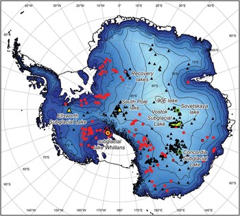
Fig. 2 Map of Antarctica showing the locations of all lakes included in the current inventory. Colours/shapes indicate the type of investigations undertaken at each site: Black/triangle = radio-echo sounding, yellow = seismic sounding, green = gravitational field mapping, red/circle = surface height change measurement, square = shape identified from ice surface feature. Vostok Subglacial Lake is shown in outline.
The inventory lists lakes in the (approximate) chronological order in which their discovery was published. In cases where recent work has produced more accurate estimates of lake parameters, or additional information has become available about a particular lake, the records have been updated from previous inventories but the position of the lake in the table remains unchanged. The reanalysis of the SOAR aerogeophysical surveys (Carter et al. Reference Carter, Blankenship, Peters, Young, Holt and Morse2007) has meant significant changes to the lower half of the Siegert et al. (Reference Siegert, Carter, Tabacco, Popov and Blankenship2005) table. As a result, ‘tally’ numbers (Table S1, column 1) greater than 100 in the present inventory are different to those of the previous version (and therefore also differ from e.g. Popov & Masolov Reference Popov and Masolov2007). Where two lakes identified in different surveys are separated by less than the length of either one they are assumed to be from the same lake. In such cases only the earlier record has been included in the inventory. Where more than one record exists for the same lake, the longest reported dimension is included in the ‘length’ column, and ‘width’ and ‘area’ are only included where an estimate of the shape of the lake surface has been made.
Acknowledgements
APW and MJS acknowledge funding from the UK NERC (NE/D003733/1) for the US-UK-Australian ICECAP program. We thank two anonymous referees for helpful and constructive comments.
Supplemental material
The inventory will be found at http://dx.doi.org/10.1017/S095410201200048X


