


INTRODUCTION
Archaeological research in the northern Maya lowlands has a long history. The state of Yucatán presents an extensive registry of archaeological sites, many of which have been explored mainly through salvage investigations and archaeological rescue as a consequence of real estate, tourist, and urban and industrial infrastructure developments, mainly in the areas of contemporary urban growth, as is the case of the city of Mérida. The growth and modernity of the current city has caused the exploration and investigation of settlements located in this territory, resulting in the registration of smaller settlements than those already known as T'ho and Dzibilchaltun.
In this article, we use the term Ichcaanziho region as the geographical space that includes the current municipality of Mérida (urban area and the small peripheral towns) that in pre-Hispanic times was inhabited by settlements that have been classified into various types according to their monumentality and distribution of structures. It should be noted that the term Ichcaanziho presents variations in terminology according to research positions using epigraphic data and ethnohistoric and/or linguistic sources, which we will not address in this article. The term Ichcaanziho, which we use in this research, is cited in the texts of Chilam Balam de Chumayel (García Campillo Reference García Campillo1995; Ligorred Reference Ligorred1998; Roys Reference Roys1957), while other place names as Ichcansihó are related to linguistic data (Barrera Vázquez Reference Barrera Vázquez1980) or, in the case of Ichkaantijoo, with ancient glyphs (Góngora Salas Reference Góngora Salas2015).
The results of research carried out to date in this region have provided new data that help illuminate the dynamics and social complexity of minor archaeological settlements. According to the classification proposed by Garza and Kurjack (Reference Garza Tarazona and Kurjack1980), these sites conform to Range IV, characterized by having few monumental structures (Garza Tarazona and Kurjack Reference Garza Tarazona and Kurjack1980:37) and a link with the highest ranking sites in the region such as T'ho and Dzibilchaltun through social, political, and economic relationships as observed in ceramics, lithic, and shell artifacts (Figure 1; Ancona Aragon et al. Reference Ancona Aragón, Aguilar, Pantoja Díaz, Arroyo, Salinas and Álvarez2018; Gómez Cobá and Pantoja Díaz Reference Gómez Cobá, Pantoja Díaz, Domínguez Carrasco, Gallegos Gómora, Torres Armijo and León Méndez2018; Góngora Aguilar and Pantoja Díaz Reference Ford2003; Maldonado et al. Reference Maldonado, Góngora, Echeverría, Domínguez Carrasco, Gómora, Torres and Méndez2019; Rovner and Lewenstein Reference Rovner and Lewenstein1997).

Figure 1. Map of the region of Ichcaanzihó with the location of the sites of the project PARME. Map courtesy of Proyecto Arqueológico Región de Mérida, Ancona Aragon, and Sergio Uribe.
Likewise, our research has allowed us to glimpse a complex development in the area, since most of the sites began their development in the Middle Preclassic (800–700 to 300 b.c.) and Late Preclassic (300 b.c. to a.d. 250). The Early Classic is characterized by a demographic boom and monumental constructive activity in the “megalithic” style (Andrews and Robles 2008; Ligorred Reference Andrews and Robles Castellanos2008, Reference Ligorred2014; Robles and Andrews Reference Robles Castellanos and Andrews2018; Quiñones Loria Reference Quiñones Loria2001, Reference Quiñones Loria2012; Uriarte Reference Uriarte Torres2016), and in the Late Classic (a.d. 600–850/900), activity construction was represented by residential foundations and vaulted structures, showing peculiar features of Puuc architecture. At the end of this period, called Terminal Classic (between a.d. 850/900 to 1050/1100), some of these sites were abandoned and towards the Postclassic (a.d. 1050/1100 to 1542) the main settlements had a quite depleted population (Robles Castellanos Reference Robles Castellanos2000:28; Robles Castellanos and Andrews Reference Robles Castellanos, Quezada, Castellanos and Andrews2013).
The last decade of research in the northeast of Mérida, in particular an area of 763 hectares (7.63 km2) analyzed in this sample, where the sites of Oxmuul, Cuzam, and Polok Keej are located, has provided information related to the organizational forms of past societies within their landscape and the different social, domestic, and ritual practices of these communities (Ancona Aragon et al. Reference Ancona Aragón, Aguilar, Pantoja Díaz, Arroyo, Salinas and Álvarez2018; Gómez Cobá and Medina Martín Reference Gómez Cobá and Martín2014; Gómez Cobá and Pantoja Díaz Reference Gómez Cobá, Pantoja Díaz, Domínguez Carrasco, Gallegos Gómora, Torres Armijo and León Méndez2018; Gómez Cobá et al. Reference Gómez Cobá, Pantoja Díaz and Zaldivar2017; Medina et al. Reference Medina Martín, Cobá, Pantoja Díaz and Stanton2014; Pantoja Díaz Reference Pantoja Díaz, Paredes, Zaldívar Rae, Arroyo, Salinas and Álvarez2018b; Pantoja Díaz and Toscano Hernández Reference Pantoja Díaz and Toscano Hernández2009; Pantoja Díaz et al. Reference Pantoja Díaz, Gómez, Medina, Hernández and Domínguez2007, Reference Pantoja Díaz, Martín, Gómez Cobá, Gamboa Angulo, Arroyo, Paiz and Mejía2012, Reference Pantoja Díaz, Martín, Gómez Cobá and Stanton2014, Reference Pantoja Díaz2018; Rivera Escamilla Reference Rivera Escamilla2012; Zaldívar et al. Reference Zaldívar, Pantoja Díaz and Gómez Cobá2015).
The main objective of our research in the northeast of the territory of Mérida is identifying the level of social complexity of these rural communities. By social complexity, we mean the processes of changes that lead the first occupants to become people with settlements and social structures that give way to privileged groups or minor elites (Lohse and Valdez Reference Lohse, Valdez, Lohse and Valdez2004; Joyce Reference Joyce1994:182) i.e., those groups of people with the ability to control, organize, and politically or economically manipulate a social group and therefore the sociocultural environment in which they develop as a consequence of the intensification of production, demographic growth, and technological development. This research contrasts with earlier studies, which focused on assigning settlement ranges based solely on the spatial extent of sites, architectural volume, and settlement densities (Garza and Kurjack Reference Garza Tarazona and Kurjack1980:19). Our work goes beyond characterizing the extension of the sites in northeast Mérida and contributes to understanding the sociopolitical and economic aspects of them (Figure 1).
THE RURAL VERSUS THE URBAN
Contemporary social researchers such as González Arellano and Larralde Corona (Reference González Arellano and Corona2013) ask: what is rural? While a difficult question to answer, they mention that the historical characteristics of rural society are essentially the predominance of agricultural work, low population density, scarce social differentiation, and social mobility (González Arellano and Larralde Corona Reference González Arellano and Corona2013:142).
Suffice to mention that the relationships and influences that have occurred between rural and urban space have led archaeology to develop theories and concepts that explain rural processes in the Maya area. Smith (Reference Smith, Schwartz and Falconer1994:144) alludes that the term “rural” is commonly used to designate individual sites or small areas with predominantly agricultural activities or entire regions with relatively dispersed populations and/or far from large cities. In both cases, rural is opposed to urban, a comparison that has led to misinterpretations (Blanton et al. Reference Blanton, Kowalewski, Feinman and Appel1982; Cloke Reference Cloke, Cloke, Marsden and Mooney2006).
An excessive focus on urban contexts, and their location within this dichotomy, has often led scholars to characterize urban areas as complex with specific and spatially restricted features such as social stratification and skilled labor, while rural areas were treated as simple and homogeneous, focused on the production of consumer goods and agricultural activities.
The aforementioned has led to the generalized idea that cities and urban populations depend on the surplus generated by rural communities, which is used to support the elite, religious specialists, professional bureaucrats, specialized artisans, and other agents who lend services without producing staple foods (Redfield Reference Redfield1953; Schwartz and Falconer Reference Schwartz and Falconer1994:1). Derived from the previous perception, meanings have arisen with a marked emphasis on the fact that residents of urban centers have a better lifestyle and greater economic well-being compared to people who live in rural areas (Ciudad Ruíz and Ponce de León Reference Ciudad Ruiz, Ponce de León, Ruiz, Ponce de León and Martínez Martínez2001; Hutson Reference Hutson2016; Hutson and Welch Reference Hutson Scott and Welch2019; Mejía Reference Mejía, Arroyo, Méndez Salinas and Ajú Álvarez2016; Schwartz and Falconer Reference Schwartz and Falconer1994:1).
There has been a growing drive, however, especially since the 1980s, to understand the social complexity of non-elite Maya communities called rural or plebeian (Arroyo Reference Arroyo, Lohse and Valdez2004; Ciudad Ruiz Reference Ciudad Ruíz1983; Joyce Reference Joyce1994; Lohse and Valdez Reference Lohse, Valdez, Lohse and Valdez2004). Some scholars have recognized that rurality is characterized by more than just agriculture (see Lamb [Reference Lamb, Hutson and Ardren2020] for a review), and instead have proposed that it is a complex sociocultural fabric that takes into account a diverse set of activities, such as agriculture, general goods production, commerce, and services. This understanding leaves behind the evolutionary dichotomy between rural and urban, which is now difficult to apply to rural settlements and populations, as well as to their diverse and integrated economic systems. This leads us to consider that the rural is no longer seen as something opposite to the urban (e.g., García Bartolomé Reference García Bartolomé1991; Schwartz and Falconer Reference Schwartz and Falconer1994; Yaeger and Robin Reference Yaeger, Robin, Loshe and Valdez2004). Instead, it is now understood that in ancient Maya cities there was a relationship of interdependence with their hinterland, which is integrated through domestic units (households), that were responsible for their own subsistence and could produce surpluses for exchange (Douglass Reference Douglas2002:4; Hixon and Mazeau Reference Hixson, Beach, Luzzadder-Beach, Dahlin and Hutson2017:169–196).
To explain the emergence of social complexity and inequality in the Maya lowlands, Ford (Reference Ford2003) argued that the first agrarian populations of the Preclassic, which settled in unpopulated regions, had low internal competition, because basic resources such as land and water were equally accessible. These societies showed low economic differentiation, social organization that was based on the family, and a subsistence-based economy. Competition increased as these pioneer populations grew, thus causing unequal access to resources (Ford Reference Ford1993:40 Quezada et al. Reference Quezada, Castellanos and Andrews2013:32; Robles Castellanos Reference Robles Castellanos, Quezada, Castellanos and Andrews2013:66–67). During the Late Classic period, the distribution of resources created conditions of inequality between social groups differentiated by their social conditions. If population growth was continuous, competition for resources would intensify and promote economic and political inequalities, and centralization indicative of a hierarchical settlement system within models of increasing social complexity (Ford Reference Ford2003:117–118), giving a pattern to what is now called “rural.”
Although Fletcher (Reference Fletcher2009:3) has also recently proposed that Maya urbanism belongs to a new comparative urban type that he calls “low-density, agrarian-based urbanism,” he avoids the urban/rural dichotomy, making that functional relationships unite urban and peripheral populations with institutions that make up social and political communities as the central aspect of the research (Marken et al. Reference Marken, Ricker, Rivas and Maxson2019:13–14; Smith Reference Smith and Smith2003).
To explain the differences in the socioeconomic complexity of households, various theories have been applied. One of them focuses on the role of environmental resources (Ford Reference Ford2003; Sanders and Price Reference Sanders and Price1968), postulating that domestic units located in areas with poor and non-fertile soils try to solve their demands differently from others that are located in soils fertile for food production. In some situations, commoners and non-elite populations intensify the production of non-agricultural goods. Households located on fertile lands, however, were able to produce enough food for their consumption needs and generate surpluses used to obtain essential non-local products, as well as high-value goods through exchange systems (Alexander Reference Alexander2000:262–264; Ford Reference Ford2003:13–19), leading to the creation of the so-called minor nobles (Marcus Reference Marcus, Lohse and Valdez2004:261) who controlled rural communities. Other theories go beyond ecological explanations (Ford Reference Ford2003; Ford et al. Reference Ford, Clarke, Morales, Arroyo, Méndez Salinas and Paiz2015; Garza and Kurjack Reference Garza Tarazona and Kurjack1981; Hixson et al. 2017:139; Sanders Reference Sanders and Culbert1973; Sanders and Price Reference Sanders and Price1968) to consider the interaction of these resources with sociocultural factors such as organization of the house and home, ritual practices, and collective memory (Inomata Reference Inomata, Lohse and Valdez2004; McAnany Reference McAnany1995; Michelet and Becquelin Reference Michelet, Becquelin, Ruiz, Ponce de León and Martínez Martínez2001; Wilk and Ashmore Reference Wilk and Ashmore1988).
The correlation between rural household organization, wealth, and agricultural potential has been demonstrated through archaeological and ethnographic studies (Ford et. al. Reference Ford, Clarke, Morales, Arroyo, Méndez Salinas and Paiz2015; Sanders and Price Reference Sanders and Price1968; Vogt Reference Vogt, Lohse and Valdez2004).These studies have shown that households corresponding to economically privileged social groups and a more prolonged occupation were located on fertile lands and were conserved over time (Dunning Reference Dunning, Lohse and Valdez2004:107; Robles Castellanos Reference Robles Castellanos, Quezada, Castellanos and Andrews2013; Vogt Reference Vogt, Lohse and Valdez2004:37). This may be due to inheritance of land from generation to generation, or because the original members incorporate entire households or members of other households who can help with agricultural work and thus increase production (Douglas Reference Douglas2002:5–7, 2019; McAnany Reference McAnany1995:99).
In the archaeological record, these domestic units are distinguished from others by the larger size of their residential structures and the greater diversity found within their domestic complexes, indicating the inequality among its inhabitants. In this case, the “founder's household wealth” theory proposes that fertile agricultural soils supported the success of some households and not others (Hageman Reference Hageman2016:214–216; Michelet and Arnauld Reference Michelet, Arnauld and Ponce de León2006; Yaeger and Robin Reference Yaeger, Robin, Loshe and Valdez2004:164). The accumulation of wealth based on the first occupation can be evidenced by a residential unit established before its neighbors that, over time, increases in size and complexity. The material and intangible resources of households, including claims to founding ancestors, can be inherited from generation to generation and kept in their collective memory to legitimize and maintain their status (Douglas Reference Douglas2002:7–8; McAnany Reference McAnany1995:99).
We agree with the criticism by Lohse and Valdez (2004:2) of the assumption that the rural population is necessarily “commoner” and the common recourse to use elite groups as a comparative metric in investigations of rural people and places. In such cases, elite populations tend to identify themselves through the acquisition of exotic goods and luxury goods, with architecture with high investments of labor and a privileged mortuary treatment, while the “commoners” are described with opposite qualities (Lohse and Valdez Reference Lohse, Valdez, Lohse and Valdez2004:2). The data collected within a region of study demonstrate that material culture is neither socially nor spatially discrete to portions of urban contexts. Thus, in the present study, we use the aforementioned fundamentals and concepts to guide our investigations on how sites within the Ichcaanziho region developed in rural areas, through their complexity over time.
METHODOLOGY
The research at the Oxmuul, Cuzam, and Polok Keej sites was salvage archaeology, a form of archaeology used “when the material evidence of human groups from the past is likely to be affected by public or private infrastructure works” according to Mexican legislation (Instituto Nacional de Antropología e Historia Reference Instituto Nacional de Antropologia e Historia2017). One of the main advantages of salvage archaeology in Mexico is the opportunity to carry out investigations in areas where archaeological sites have not been previously reported and where there is little possibility of conducting large-scale investigations. Depending on the infrastructure project, a sample of the site will be explored, which makes it possible to study a wide range of pre-Hispanic constructions, especially in many cases the periphery of the settlements, as well as the possibility of creating archaeological reserves in the nuclei of sites for their protection and conservation and future research (Ligorred Reference Ligorred2018; Pantoja Díaz Reference Pantoja Díaz2018b).
Our study focused on a polygon located in the northeastern part of the municipality of Mérida, between the modern small village of Chichí Suárez and Sitpach. In the surroundings, the sample includes other archaeological sites such as Techoh to the east, Flor de Mayo to the southeast, and Pacabtun to the west. According to the classification system established for the Archaeological Atlas of the Yucatan State, Flor de Mayo is categorized as a Rank III site, while Techoh and Pacabtun were classified as Rank IV (Figure 1; Garza and Kurjack Reference Garza Tarazona and Kurjack1980).
The first phase of the investigation was based on the recognition of the surface features, which allowed us to obtain the cartography of the study polygon and to visualize the distribution of the sites. The next stage consisted of the systematic archaeological excavation, focused on analyzing the architectural characteristics of pre-Hispanic buildings, the detection of special contexts, and the identification of occupational sequences through the study of architecture. Various analyses of the artifacts recovered in the excavations were carried out. Ceramics were classified using the type-variety system, commonly used in the Maya area, and were also studied through the analysis of formal and decorative attributes. Malacological materials were classified by biological taxonomic identification and typological classification, and visual analysis was utilized for the provenance of lithic materials.
ARCHITECTURAL EVIDENCES OF THE COMPLEXITY OF THE SETTLEMENT
In our settlement analysis, two aspects were taken into account: the type of structures and their dispersion in the territory, which allowed us to observe associations to identify architectural groups (Figures 2 and 3). In total, 686 archaeological structures were registered, which were classified by the typology used in northern Yucatan and by PARME (Proyecto Arqueologico Region de Mérida; Pantoja Díaz Reference Pantoja Díaz2018b; Pantoja Díaz and Jiménez Álvarez Reference Pantoja Díaz, Álvarez, Hernández and Domínguez2007:224–225; Sabloff and Tourtellot Reference Sabloff and Tourtellot1991:14; Sierra Sosa Reference Sierra Sosa1994) that are described below (see Lamb [Reference Lamb2022] for a classification of similar architectural remains).

Figure 2. Typology of the structures of the PARME project. Images courtesy of Pantoja Diaz and Miguel Salamar.

Figure 3. Location of the Cuzam, Oxmuul, and Polok Keej sites. Courtesy of Archive PARME.
Excavations were carried out to address the ways in which these various building classes were spatially distributed in the region over time. Of the archaeological structures recorded during the study, 50.4 percent (N = 346) were excavated, of which only 155 (23 percent) were relatively dated based on the analysis of the ceramics.
Buildings predominantly of domestic or minor architecture were classified into two main categories—the platform and the foundation—with variants determined by morphological and constructive characteristics, the pyramidal platform variant (Figures 2 and 4a) being the least represented (N = 4, 0.58 percent). These buildings represent the largest constructions on record and are the ones with the highest height and construction volume. They measure between 12 and 23 m long, 11 and 27 m wide, and three and seven m high. Due to their large dimensions and the presence of architectural features such as front staircases, rounded corners, talud panels, and altars as superstructures, these pyramids probably performed a civic-ceremonial function as shrines and altars (Figure 4).
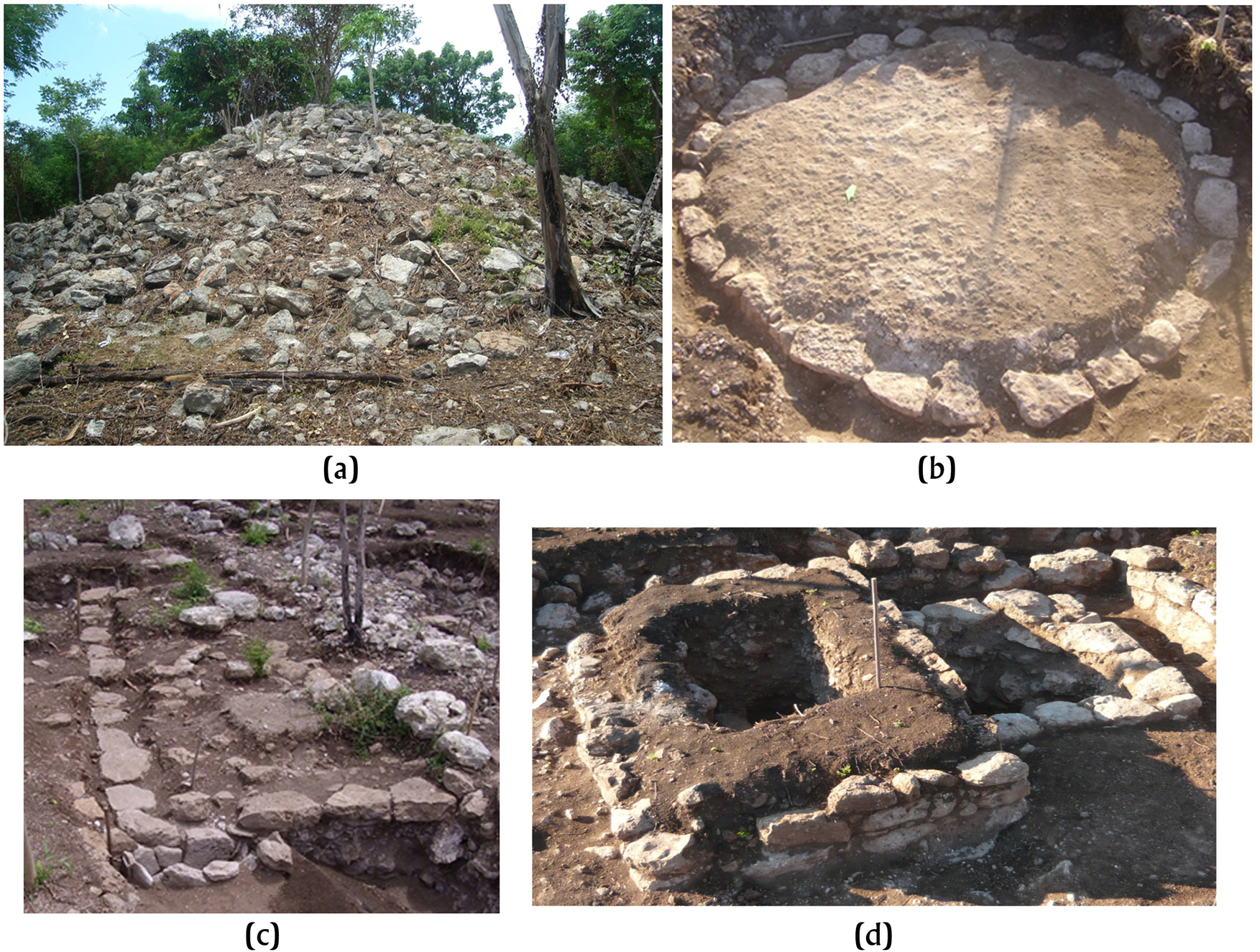
Figure 4. (a) Pyramidal platforms. (b-d) Domestic and ritual Preclassic substructures uncovered during excavations at the Oxmuul and Polok Keej sites. Photographs courtesy of Archive PARME.
The next category is the basal platform or basamento (N = 217), which represents 31.56 percent of all registered buildings (Figure 2). These buildings consist of a raised space with retaining walls on all sides, made with carved stones and having variable construction characteristics. Based on their architectural form and the archaeological materials recovered, it can be inferred that their function and use correspond to residential units with buildings constructed with perishable materials. This form of residential architecture is commonly found throughout the northern lowlands (e.g., Kurjack Reference Kurjack1974; Lamb Reference Lamb2022; Ringle and Andrews Reference Ringle, Andrews, Ashmore and Wilk1988; Quintal Suaste Reference Quintal Suaste1993). Another less elaborate platform variant was called leveling, which is the result of an adaptation of the topography of the terrain. A leveling consists of an artificially raised surface that takes advantage of a natural rise in the terrain, such as rocky outcrops or a slope of natural elevation, using small stones and earth without using retaining walls, which creates an adequate circulation space (Figure 2; Pantoja Díaz Reference Pantoja Díaz2018a:13).
The foundation structures are constructions that would have directly supported a building made of perishable materials such as wood and palm roofs. The foundation structures are distinguished from the platforms by to their surface area, almost equal to the space of the constructions they supported, and, in some cases, low masonry walls of up to 0.60 m made up of two or three courses of stone.
The last category, a type of minor construction, is a type of foundation called a Ch'iich ’mound (Figure 2). Ch'iich mounds are small, low mounds formed by concentration of small stones, without any stone delimitations serving as retention walls. Their dimensions vary, but they should not exceed five meters in diameter and their height ranges from 0.20 to 0.50 m at the most. They varied in construction material from small, stones 1 cm in diameter to stones the size of a fist (Andrews and Ringle Reference Andrews and Ringle1992; Pantoja Díaz Reference Pantoja Díaz1997; Ringle and Andrews Reference Ringle, Andrews, Ashmore and Wilk1988).
The minor constructions were found in a high percentage with respect to the platforms and levelings. This is the case of foundations (N = 211, 32.17 percent), which were outnumbered by Ch'iich mounds (N = 244, 35.57 percent). In general, Ch'iich mounds and foundations are associated with residences and domestic activities. Regarding the second facet of the settlement analysis, the three defined sites, Oxmuul, Cuzam, and Polok Keej (Figure 3), are discussed throughout the next section concerning the diachronic changes in the settlement patterns of Ichcaanziho, the participation in regional and long-distance exchange, domestic economies, and local social relations.
THE CHANGING CULTURAL LANDSCAPE OF ICHCAANZIHO
From the 155 excavated structures, a total of 137,408 ceramic sherds were recovered. They were analyzed using the type-variety classification system in order to identify their chronological occupation and intercultural relationships. Of the total of sherds studied, 99 percent were identified through typology, and their distribution was examined to detect possible patterns in the acquisition of certain ceramic goods.
Particular attention has been paid to the differences between the larger structures, made up of the main architectural groups, and the smaller buildings that extend outward from the central areas. To date, no studies have been conducted on ceramic production in the region, so it is not possible to make any inferences on this issue.
The analysis of lithic artifacts, including chert (N = 713), obsidian (N = 264), limestone (N = 193), greenstone (N = 30), in addition to the 883 shell artifacts, evidences the production activities in the framework of subsistence household economies. Here, we observe a lack of surpluses that exceed the family's consumption needs. Lithic and shell artifacts also attest that households were able to purchase imported goods, such as jade, obsidian, and shell, from both the Pacific and lake environments, as well as those from the Gulf and the Caribbean.
PRECLASSIC: MIDDLE PRECLASSIC (800/700–300 b.c.) AND LATE PRECLASSIC (300 b.c–a.d. 250)
Ceramic and architectural data revealed that the earliest occupation in the study area dates to the Middle Preclassic. A total of 75 structures are associated with this period, while 54 buildings were dated to the Late Preclassic, which indicates that 83 percent of all the buildings registered in our study area were occupied from the Middle Preclassic.
The buildings of these periods correspond to substructures covered by later construction events and consist of small, basal platforms and foundations with walls of one or two courses of rectangular stones. Some of these foundations were completely covered with stucco (Figures 4b–4d).
The recovered Middle Preclassic ceramics belong to the Joventud, Dzudzuquil, Chunhinta (Ucu), Sabán (especially the unslipped Sabán type) ceramic groups and, less frequently, Pital. The Middle Preclassic represent 6 percent (N = 7,920) of all the materials analyzed and generally fit into the Early Nabanché sphere, which predominated in northern Yucatan (Figure 5). The Late Preclassic ceramics represent 15 percent (N = 20,386) of all the materials analyzed and the most abundant ceramic groups are Sierra, Polvero, Unto, Tipikal, and Saban (especially the Striated Chancenote type). Less frequent are the Flor and Escobal groups. As in the Middle Preclassic, the Late Preclassic inhabitants of Ichcansihó used local vessels that have been reported at other sites in northern Yucatan. The number of vessels imported from other regions of the Maya area such as central and southern Campeche, however, increased during the Late Preclassic. Imported ceramics include the Sierra and Polvero groups that exhibit a well-adhered, waxy slip. This differs from the northern Yucatan slips, which are distinguished by their chipped appearance. Other examples of ceramics acquired through regional exchange are the Flor and Escobal groups (Figure 5). Most of the Preclassic buildings fulfilled domestic functions, evidence by the presence of utilitarian ceramics, metates, and edible mollusks. A greater concentration of buildings dating from this early period was found in the central part of each site (Oxmuul, Cuzam, and Polok Keej). Preclassic structures at these sites were built at bedrock elevations throughout the landscape (similar to what Ciudad Ruíz [Reference Ciudad Ruíz1983:14] reports at Agua Tibia, Guatemala, and Arroyo [Reference Arroyo, Arnauld and Breton2013:171] in sites on Guatemala's Pacific coast, among others). Each group of Preclassic structures was associated with a natural well that reached groundwater levels. Such wells were the only water sources to which the ancient settlers would have had access, due to the absence of cenotes (Figure 6). During this first period, buildings such as the ball court located in Polok Keej, in the northern part of the study area, and the pyramidal platforms in this area, had civic-ceremonial functions (Figure 7). Other particular building where civic-ceremonial activities were carried out were Structure 461 located in the Chan Muuch architectural group within the Oxmuul site (Figure 8a). During its exploration, eight substructures were registered; including a two-level circular structure and a set of three foundations distributed in a triadic arrangement, in addition to four miniature constructions that represent pyramids and buildings with stylistic features of the Peten and made of masonry, stone walls brought together with lime mortar, and covered with stucco (Pantoja Díaz et al. Reference Pantoja Díaz2018). Similar miniature buildings have been reported in the vicinity of Oxkintok (Ancona Aragón et al. Reference Ancona Aragón, Uc and Morales2014). The ceramic analyses determined that Structure 461 had a prolonged occupation from the Middle Preclassic that extended to the Postclassic, with substructures dating to the Middle and Late Preclassic. The four architectural miniature replicas (Figure 8b) in particular date to the final part of the Late Preclassic or Protoclassic.
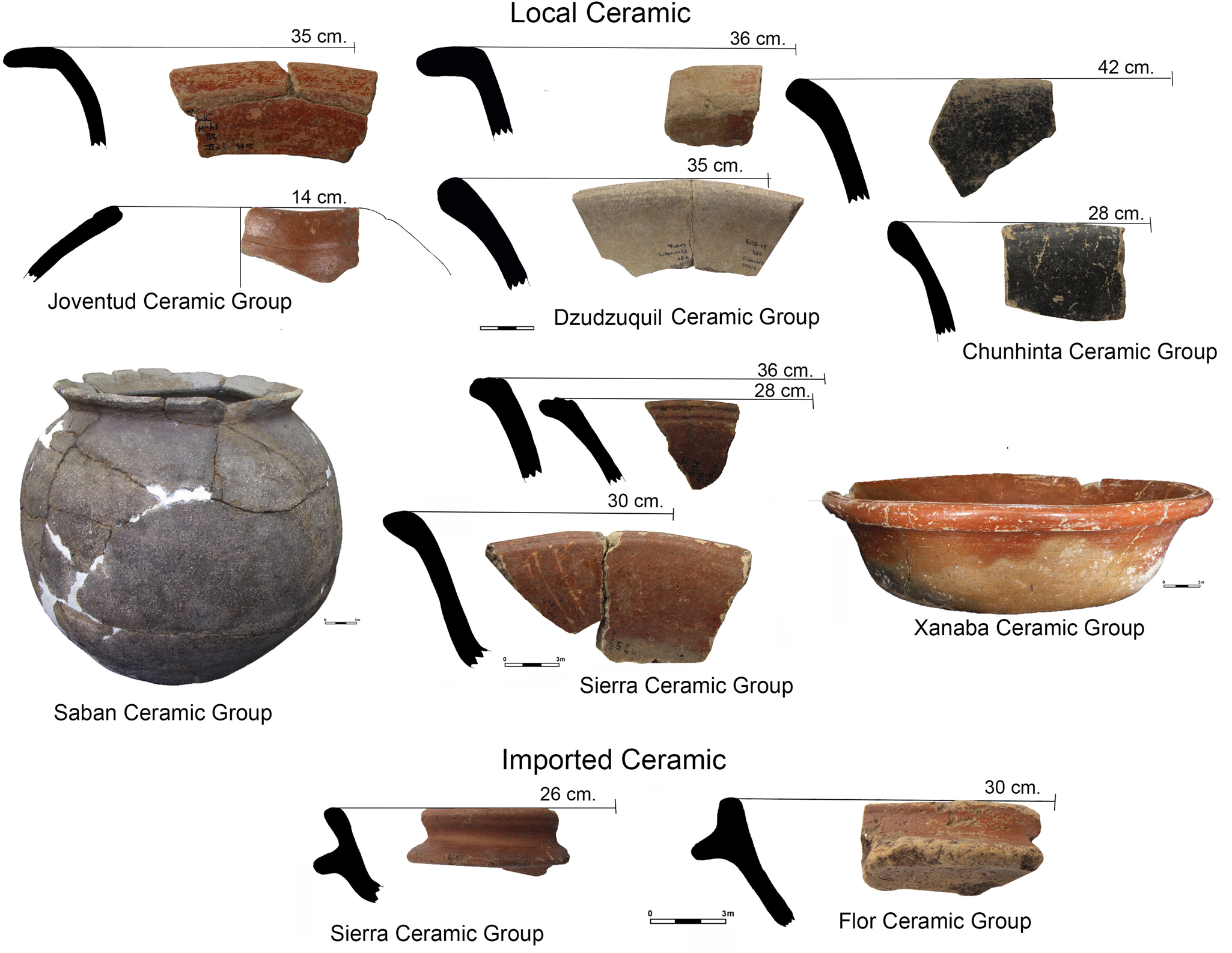
Figure 5. Middle Preclassic and Late Preclassic Ceramics of the PARME project. Images courtesy of Ancona Aragon and Archive PARME.

Figure 6. Map of the Oxmuul site and residential group Chan Much, showing natural wells that reached groundwater levels. Wells associated with Structure 315 of Oxmuul. Photographs and drawings courtesy of Archive PARME.

Figure 7. Map of Polok Keej. Map courtesy of Pantoja Díaz, Sergio Uribe, and Archive PARME.

Figure 8. (a) The Structure 461 within the Architectural Group Chan Much that belongs of the site Oxmuul. (b) Substructures of miniature architectural replicas of the Structure 461 of the site Oxmuul. Photographs and images courtesy of Pantoja Díaz and Archive PARME.
Another Preclassic civic-ceremonial building was Structure 317, which had at least one direct primary, containerless burial (Burial 42) found in the building's fill, as well as secondary burials placed in urns (e.g., burials 74 and 75; Figure 9a).

Figure 9. (a) Funeral burial in substructures Preclassic in the Structure 317 of Oxmuul and funeral urn found in situ in Cuzam Structure 380 of the Late Preclassic Period; (b) vessel clean and restored; (c) green stone bead, and (d) obsidian blades. Photographs courtesy of Archive PARME.
Cremated bones were found inside some of the aforementioned burial urns, for example in Structure 390. In Oxmuul, 96 burials were excavated, three primary burials were identified in Polok Keej (the rest could not be identified), and in Cuzam 25 burials were found, four of which were secondary.
Structure 390 at Cuzam was a civic-ceremonial building and, also provided relevant temporal data in both ceramics and burial contexts. A rectangular vessel of the Polvero Negro type was recorded, which appears to have served as a mortuary urn and contained cremated human remains, lithic artifacts such as jadeite beads, and prismatic obsidian blades from San Martín Jilotepeque (Figure 9b). The rectangular shape of the vessel is uncommon in the northern lowlands. This urn indicates that the inhabitants of the house had resources that allowed them to access prestigious goods that guaranteed them a privileged position with respect to other social groups.
EARLY CLASSIC (a.d. 250–600)
Settlement patterns show various changes during the Early Classic. While 23 percent (N = 36) of the structures built in the Preclassic had no evidence of Early Classic occupation, most of the buildings continued to be occupied during this time. In addition, it was observed that, in general, the stones used in Early Classic architecture have larger dimensions than those used during the Preclassic. While settlements were more dispersed during the Preclassic, Early Classic populations built structures closer to existing, high-status residential groups.
The evidence also suggests that previous residents renovated their houses, expanding them to greater dimensions. The new phases of the civic-ceremonial buildings covered the older ones, and the builders carefully buried the previous construction phases without dismantling them. Preclassic buildings were expanded and turned into platforms, thus acquiring larger surfaces. These new buildings acquired domestic functions. This evidence was found in Structures 317 and 461, which were preserved and the collective memory of these buildings appear to have persisted, since they were not affected by subsequent renovations or burials. The Early Classic settlement consists in large concentrations of structures that make up the architectural nuclei of Oxmuul, Cuzam, and Polok Keej.
Of all ceramic materials, 15 percent (20,684 sherds) date to the Early Classic. The most common ceramic groups pertaining to the Early Classic are Oxil, Timucuy, Shangurro Hunabchén, Maxcanu, Chuburna and Dzidzibachí, and in lesser quantities, Triunfo, Balanza, Águila, Tituc, Carolina, Acu, Chencoh, and Kochol (Figure 10a). Based on the typological distribution of the ceramic groups, it appears that residents of our study area used vessels of the regional tradition from the northern Yucatan settlements (they approximately represent 13 percent of the total of the Early Classic), including (a) common ceramics at sites within Mérida and its surroundings, and (b) ceramics from western Yucatan where sites such as Oxkintok are located (Varela Reference Varela Torrecilla1998; see Lamb [Reference Lamb2022] for a similar ceramic repertoire). Only 2 percent of the Early Classic ceramics are related to vessels that came from distant regions such as the eastern region of the Yucatan peninsula and the south and center of Campeche (Tzakol ceramic sphere).

Figure 10. Early Classic ceramics and lithics. (a) Early Classic ceramics; (b) obsidian blades; (c) flint artifacts; and (d) limestone artifacts. Images courtesy of Gongora Aguilar and Archive PARME.
During the Early Classic, residents acquired obsidian in the form of bifacial tools and prismatic blades. The macroscopic analysis of the obsidian recovered from that period of time indicates these artifacts came from Chayal (N = 10) and Ixtepeque (N = 7) in Guatemala (Figure 10b), which suggests that the inhabitants of the interior portions of northern Yucatan participated in the long-distance exchange through redistribution systems (Braswell Reference Braswell, Glascock, Laporte, Arroyo and Mejía2007; Nelson Reference Nelson, Serra Puche, Olguín and Zabé1994).
Inhabitants also produced their own chert blades for self-consumption, as evidenced by the presence of cores and flakes found in domestic structures of the three monumental architectural complexes. In addition to producing their own flakes, residents also acquired stone bifaces, notably oval-tipped tools (Peniche May et al. Reference Peniche May, Aguilar and Díaz2006; Rovner and Lewenstein Reference Rovner and Lewenstein1997; Sheets Reference Sheets, Hester and Shafer1991). Some tools showed signs of recycling and maintenance. The macroscopic characteristics observed in the material of the bifacial tools suggest that they were possibly obtained in areas near the well-known workshops south of Yucatan in the Puuc or in the Río Bec region (Figure 10c; Rovner Reference Rovner1975). Finally, tools made of limestone, such as hand mills, metates, hammer stones, smoothing stones, and rounded stones, found in residential groups reveal activities related to food processing and carving (Figures 10c and 10d). The Early Classic lithic assemblage shows that, in addition to intrafamily production and consumption, Early Classic households participated in regional and long-distance commercial economies.
LATE CLASSIC (a.d. 600–850/900) AND TERMINAL CLASSIC (a.d. 850/900–1050)
During the Late Classic and Terminal Classic, most (90 percent, N = 140), of the explored structures were occupied from earlier times such as the Preclassic and/or Early Classic. During the Late and Terminal Classic, only five structures were built, which were associated with residential groups of continuous occupation (Figure 11). In the Late Classic, 59 percent of the structures occupied consisted mainly of platforms (N = 51).

Figure 11. Map of the Cuzam and its residential groups. Map courtesy of Archive PARME.
In contrast to Early Classic builders, who covered pre-existing Preclassic structures, Late Classic occupants took advantage of the pre-existing walls of earlier structures to increase the horizontal area of the structures through building extensions, allowing their platform to have more superstructures and common spaces such as patios and circulation areas (Figure 12b).

Figure 12. (a) Terminal Classic architecture, C” plan constructions that are simple or in tandem from Oxmuul site; (b) hypothetical reconstruction of structure 317 of Oxmuul. Images courtesy of Miguel Salazar and Archive PARME.
We observe architectural changes such as the presence of double-sided masonry walls, as well as constructions with a “C” plan that appear in the Terminal Classic (Huchim Herrera and García Ayala Reference Huchim Herrera and Ayala2000:137–144), either simple or in tandem, such as those observed in Puuc architecture (Figure 12a). These structures are indicators of late periods and the presence of external contacts to the Maya area, as well as a reflection of exchange (Arnauld Reference Arnauld, Ruiz, Ponce de León and Martínez Martínez2001; Barrera Rubio Reference Barrera Rubio1989; Barrera Rubio et al. Reference Barrera Rubio, Peraza, Pantoja, Delgado and Estrada2001; Huchim Herrera and García Ayala Reference Huchim Herrera and Ayala2000; Pantoja Díaz et al. Reference Pantoja Díaz, Martín, Gómez Cobá and Stanton2014; Tourtellot Reference Tourtellot, Wilk and Ashmore1988). Of all the registered buildings dated in these periods, 24 percent consisted of levelings while only 16 percent (N = 14) of the structures were foundations and Ch'iich mounds.
The Oxmuul, Polok Keej, and Cuzam settlements reached their peak occupation during the Late Classic, that is, the structures were more concentrated and formed residential units. The population density was manifested through architecture, with the use of larger houses with superstructures that shared common areas such as courtyards for domestic activities. Civic-ceremonial structures also grew and pyramidal platforms stood out in the landscape, although the Polok Keej's ball court underwent only minor modifications. Late Classic burials were found in structures that can be defined as residential units of higher status, classified in this way by their dimensions and construction characteristics. The use of funerary cists was common during this period (Figure 13) and mainly primary burials were found, observing, in some cases, that the secondary burials were placed in the same burial spaces as the primary ones.

Figure 13. Burials of individuals deposited in cist. Photographs courtesy of Archive PARME.
These mortuary contexts revealed many segments of the occupying pre-Hispanic population, as men, women, adults, and children were found with paraphernalia and offerings made of local and imported materials (Medina et al. Reference Medina Martín, Cobá, Pantoja Díaz and Stanton2014). Infants were deposited inside ceramic urns (Figure 14) that were, for the most part, jars from the Chuburna and Ich Canziho groups. These vessels were modified to introduce human bones and then covered with plates or fragments of other vessels (Gomez et al. 2019; Pantoja Díaz et al. Reference Pantoja Díaz, Martín, Gómez Cobá, Gamboa Angulo, Arroyo, Paiz and Mejía2012:267).One particular case is the discovery of vessels from the Ich Canziho ceramic group found in Structure E-317 that seem to have been manufactured with the purpose of serving as urns.

Figure 14. Burials of individuals infants that were deposited inside ceramic urns. Photographs courtesy of Archive PARME.
Individual residences exhibited between one and four burials and, only in one case, more than one hundred individuals buried with Structure E-317 at Oxmuul. Bowls, plates, and miniature vessels were part of the funeral kit (Zaldivar et al. Reference Zaldívar, Pantoja Díaz and Gómez Cobá2015) and the funeral paraphernalia consisted of earrings, beads, pendants, and rings, as well as other luxury items that were mainly made of shell (Figure 15a), animal bone (Figure 15b), and greenstone. Regarding the ceramic materials of the Late Classic (42 percent, N = 57,834 sherds) and the Terminal Classic (19 percent, N = 26,429 sherds), two assemblages were identified through the type-variety classification, as well as through formal and decorative attributes. The first assemblage (Figure 16) is composed of vessels commonly found in all residential units, consisting in Ich Canziho, Muna, Chuburna, Teabo and Ticul ceramic groups. Within these groups, the predominant forms were the following: (1) Ich Canziho jars with striations on the body; (2) Muna dishes, jars, plates, and bowls with decorations dominated by the simple monochrome slip (Muna slate type) and the decoration with black paint (Black Sacalum on slate type); (3) Chuburna dishes, plates, bowls, and pans decorated with a simple mottled brown slip; (4) Teabo bowls decorated with the monochrome red slip that distinguishes the ceramic group, and (5) Ticul small vessels, such as dishes, and bowls, decorated with the monochrome slip that distinguishes the ceramic group.

Figure 15. Different shell ornaments and animal bones. (a) Freshwater shells from the Usumacinta river region; (b) seashells of the Caribbean Province; (c) zooarchaeological artefacts in recovered in mortuary contexts. Photographs courtesy of Gomez Coba and Archive PARME.

Figure 16. Late Classic and Terminal Classic ceramics (first assemblage). Images courtesy of Ancona Aragon and Archive PARME.
The second assemblage is a selection of ceramics only identified in larger residential units (such as Structures E-317 and E-461, which were also ceremonial in early periods).This assemblage presents the four previously mentioned groups (Muna, Chuburna, Teabo, and Ticul) but with very elaborate decorations (Figure 17a). These groups include vessels such as tripod plates/bowls, high-walled bowls, composite silhouette bowls, and miniature jars with complex decorations such as geometric shapes, pseudo-glyphs, and panels with anthropomorphic designs (Figure 17). Although their distribution extends to many sites in the north of Yucatan, these vessels are part of a local tradition in the study region since this area is where there is a greater presence of these ceramics. This second set, however, also includes a variety of groups and types represented in less quantity, such as Dzitya, K'inich, Maxcanu, Egoista, Infierno, Arena, Baca, Nimun, Saxche, Chimbote, Cui, and Palmar. These vessels were acquired through exchange with regions such as central and southern Campeche and the northwest coast of Yucatan.

Figure 17. Late Classic and Terminal Classic ceramics (second assemblage). Images courtesy of Ancona Aragon, Guillermo Kantú, Aurea Hernandez, and Archive PARME.
By the end of the Late Classic and throughout the Terminal Classic, the Oxmuul, Cuzam, and Polok Keej sites acquired a significant number of vessels through long-distance exchange with regions such as the Usumacinta River. Here, the Chablekal, Yalkox, Silho, and Balancan groups figure prominently. For our sites, we identified the existence of unique vessels, adorned with glyphs and representations of the elite, specifically among vessels from the Chablekal and Yalkox groups (Figure 17). This is evidence of the high economic power of its former inhabitants.
Lithic materials from the Late Classic and Terminal Classic show that obsidian prismatic blades were made from imported polyhedral cores. Casual flake production and modification of flakes to create preforms for prismatic blade tips is also evident. These were found with greater frequency in Structures 317, 461, 465, and 408. Most of the recovered obsidian comes from El Chayal (N = 112). Significant quantities of Ixtepeque obsidian were also imported (N = 87). Obsidian materials from central Mexico come from Pico de Orizaba, Veracruz (N = 8), Pachuca (N = 6), and Ucareo/Zaragoza (N = 16).
The ability to acquire obsidian from these more distant sources shows the high purchasing power of social groups and their participation in long-distance trade through distribution nodes (Figures 18a and 18b), thus reflecting the existence of mechanisms of economic circulation of a variable nature (Morgado Rovira Reference Morgado Rovira2009) probably of low intensity, adhering to the proposal of Rice (Reference Rice, Brumfiel and Earle1987:77, 85), who mentions that the exchange of some goods such as obsidian would have been restricted to the domestic sphere and that a central authority would have acted as a redistributive entity.
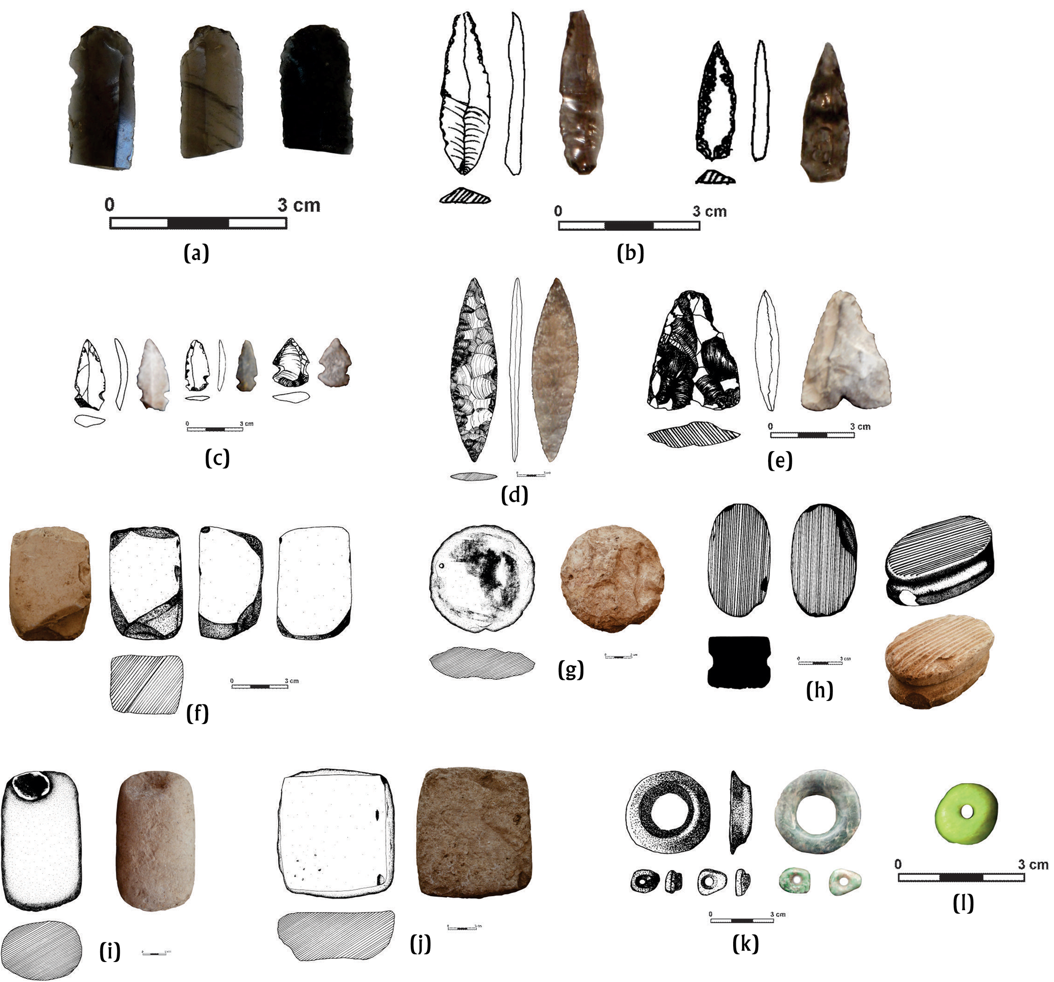
Figure 18. Lithic artifacts of the Late Classic and Terminal Classic period. (a) Obsidian razors; (b--e) flint artifacts; (f--j) limestone artifacts; (k and l) green stone artifacts (second assemblage). Images courtesy of Gongora Coba and Archive PARME.
Simultaneously, the artifacts show an increase in the production of percussion blades and casual flakes, consumption of bifacial tools such as oval and lanceolate tips, and recycling of these bifacial forms to elaborate Celts (Figures 18c–18e). Limestone artifacts show significant changes, better finish, workmanship, and more variety of tools such as polishing stones, discs, and bark beaters. Smoothing stones were related to construction, while limestone discs were used as caps for bee hives (Paris et al. Reference Paris, Castrejon, Walker and Lope2020). Bark beaters were used in making paper. Stone artifacts appear more frequently (60E percent, N = 116) in larger structures such as E-317, E-465, and E-480. The most common stone artifacts found were manos (hand-ground stones), spherical stones, and metates (Figures 18f and 18g).
The inhabitants of the Oxmuul, Cuzam, and Polok Keej also acquired imported greenstone objects. These include beads, earspools, and pendants (Figures 18k and 18l), which were recovered from mortuary contexts of residential complexes in Structures E-317, E-461, E-468, and E-475 (from Oxmuul). The acquisition of imported goods during this period is also reflected in the presence of shell ornaments made from freshwater mollusk species of the Unionidae family. These mollusks are found in the rivers and tributaries of the Usumacinta River on the current border of Mexico and Guatemala. Unionidae shell objects were deposited mainly in mortuary contexts (Gómez Cobá and Pantoja Díaz Reference Gómez Cobá, Pantoja Díaz, Domínguez Carrasco, Gallegos Gómora, Torres Armijo and León Méndez2018).
POSTCLASSIC (a.d. 1200–1450)
The evidence of a Postclassic occupation was minimal, indicated by the presence of ceramics from this period, recovered in only 26 buildings. Structure E-469 was the only building with architectural features of the Eastern Coast or “Costa Oriental” style (Zúniga Carrasco Reference Zúñiga Carrasco2016). The presence of the Postclassic is observed in structures with long occupational sequences that extend from the Preclassic to the Classic. Evidence of this late occupation focused on the central areas of the main architectural precincts, possibly indicating pilgrimage.
Postclassic ceramics represent two percent of all ceramic materials (N = 2,911) and only the Mama and Navula groups were identified (Figure 19). These groups have been previously reported in various settlements within the northern Maya lowlands, such as Mayapan (Smith Reference Smith1971).
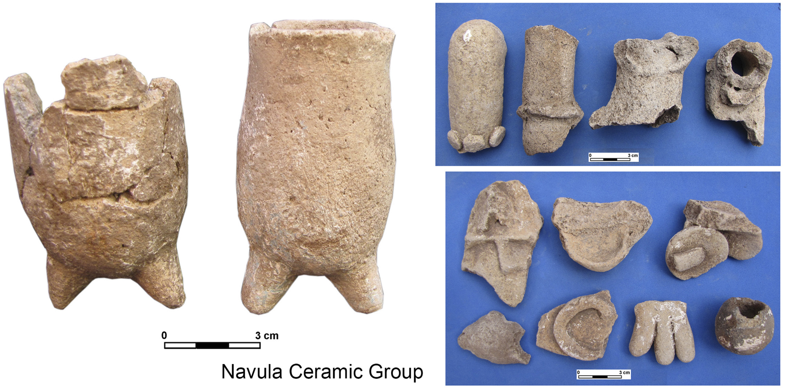
Figure 19. Postclassic ceramics of the PARME project. Photographs courtesy of Ancona Angora and Archive PARME.
DISCUSSION
The results obtained in the archaeological research carried out by PARME in the northern Mayan lowlands, particularly in the northeast section of the so-called Ichcaanziho region allowed us to get closer to understanding the social development of the rural settlements that surrounded cities such as T'ho and Dzibilchaltun that could have functioned as regional capitals throughout the occupation of Oxmuul, Cuzam, Polok Keej, as well as small hamlets which make up different architectural ensembles. This information was derived from the analysis of the settlement pattern, the architecture, the funerary contexts and the various recovered artifact classes.
Preclassic monumental architecture in the study area was minimal, owing to the rural nature of the settlement, compared to settlements such as Komchen (Andrews Reference Andrews1989; Andrews and Ringle Reference Andrews and Ringle1992) and Xtobe and Poxila (Anderson Reference Anderson, Robles Castellanos and Andrews2003; Ceballos Gallareta and Robles Castellanos Reference Ceballos Gallareta and Castellanos2012) located in the northwest sector of the Mérida region. The Middle Preclassic ceramic repertoire of Oxmuul, Cuzam, and Polok Keej, however, was similar to those reported in these sites with monumental architecture in northern Yucatan and shows a regional distribution with low levels of imports.
The evidence of minor architecture in the Preclassic corresponds to the settlements that present a dispersed settlement pattern, associated with natural features such as wells connected to the water table. Following Dunning (Reference Dunning, Lohse and Valdez2004), ecological conditions were determining factors for this period. The few existing civic-ceremonial structures remained during the Early Classic, while other buildings were covered by new construction events in which structural modifications changed their use and function, giving them a residential character, showing thus the social complexity of these settlements. It was observed that domestic units grew, demonstrating greater organization and investment in labor and technological advances in construction systems. We can infer that the water-controlling groups were maintained over time by linking to the founding families (Douglas Reference Douglas2002), which legitimizee their claims to these important resources over time (see also Lemonnier and Arnauld Reference Lemonnier and Arnauld2022). Technological development in construction techniques is reflected in the construction of various containers (cisterns or chultunoob, granaries, and other types of stone containers), kilns for the production of lime, and the exploitation of local resources such as sascab.
According to the arguments of Ford (Reference Ford2003) previously mentioned, these social groups could have exchanged with the urban places of the region, such as Dzibilchaltun, Flor de Mayo and T'ho, their agricultural surplus for imported goods. One way of explaining the arrival of such goods is that the minor elites of the rural centers had interaction with urban centers. These rural elites provided urban settlements with agricultural surplus and, as a consequence, the groups of higher status in these small sites acquired through exchange products that came from afar since the rural settlements controlled key resources such as land, lime, and agricultural products among others. In this way, they reached an economic position that allowed them to acquire sumptuous items through long-distance trade.
Cities like T'ho and Dzibilchaltun that occupied higher positions within the settlement hierarchies presumably attracted and controlled a greater variety of products (e.g., polychrome ceramics, obsidian, and chert, among others) compared to the rural settlements. Despite this, some rural families with more status were also able to acquire these goods and lived in important architectural groups located near the central geographically privileged areas, such as the Sajal identified in a funerary offering at the Oxmuul site (Figure 17). Throughout the investigations in the Maya area, it has been suggested that rural sites were under the hegemony of large sites such as capital cities T'ho and Dzibilchaltun. According to Izquierda y de la Cueva (Reference Izquierdo y de la Cueva2018), however, a heterarchical political and economic organization may have occurred in these complex rural sites during the Late and Terminal Classic.
FINAL CONSIDERATIONS
The archaeological evidence recovered in the investigations in the settlements studied in the northeast of the Ichcaanziho region, particular in Oxmuul, Cuzam, and Polok Keej, allowed interpreting through diachronic investigations in these rural communities, which began in the Middle Preclassic as scattered and simple settlements. This also let us to observe and reveal housing complexes whose genesis was the conditioning of the environment, dependent on natural resources, observed through architectural and settlement patterns.
Through the material evidence found in the rural sites of Oxmuul, Cuzam, and Polok Keej, we can affirm that a small group of people had the ability to acquire prestigious goods, despite forming small communities, regardless of their interference in the systems commercial distribution. This social phenomenon not only suggests that it arises in the largest and most urbanized cities. These rural settlements presented a social complexity palpated by their regional economic dynamics. This role allowed them to become semi-autonomous political entities with their own methods of organization and social control, without ceasing to be in interaction with nearby capitals such as T'ho or Dzibilchaltun through a hegemonic relationship or, in the case of Flor de Mayo, a heterarchical organization.
The data analyzed from Oxmuul, Cuzam, and Polok Keej showed that they overcame the threshold of rural area towards the Late and Terminal Classic. The notion of the rural does not correspond solely to a geographical delimitation, the production of consumer goods, or the amount of population. Rather, “rural” refers to a complex social and economic fabric, in which commoners achieved greater purchasing power including imported prestigious goods, thus creating minor elites or commoners with status.
It was possible to observe, through the constructive and architectural characteristics of our study region, the influences of larger entities. Although on a smaller scale compared to the characteristics found in nearby regional capitals such as Komchen, Acanceh, Dzibilchaltun, and, further afield, Oxkintok, where the architectural influence of the southern Mayan lowlands or Peten is visible, these characteristics were replicated in some of the constructions, specifically in the representations of miniature buildings.
It is possible that, in the various periods analyzed, these communities evolved without leaving their rural environment based on the number of smaller structures, production areas (furnaces) and quarries, aquifers represented by wells and cenotes, that were controlled by social groups to maintain a higher status within the settlement. Finally, the inhabitants of the studied sites replicated on a smaller scale various social, ritual, and economic patterns reported in urban centers, as observed in funerary patterns, ceramic tableware, and various objects and tools, without leaving their essence of homogeneous communities focused on production and social conditions, as discussed by various scholars of the Maya culture.
RESUMEN
Durante la última década, las investigaciones arqueológicas llevadas a cabo por el Proyecto Arqueológico Región de Mérida (PARME) a través del Instituto Nacional de Antropología e Historia (INAH), se han centrado en los sitios periféricos del actual municipio de Mérida. En este escrito nos centraremos en la sección noreste abarcando un polígono que tiene una superficie de 7,19 km2 en el cual se ubican los sitios menores que podemos interpretar como rurales, tales como: Oxmuul, Cuzam y Polok kéej. Dicha área fue explorada en diversas temporadas como resultado de proyectos de salvamento y rescates arqueológicos, realizándose trabajos de recorrido de superficie con el objetivo de crear la cartografía, excavaciones sistemáticas y análisis descriptivos de los materiales arqueológicos. Uno de los objetivos fue entender e interpretar la organización social de las antiguas comunidades periféricas a los sitios de mayor rango como T'hó y Dzibilchaltún. Los resultados obtenidos, se presentan de manera diacrónica con el objetivo de explicar el papel que jugaron estos sitios dentro de la economía política de la región, que los convierte en sitios rurales complejos hacia el final del periodo clásico.
ACKNOWLEDGMENTS
We thank the National Institute of Anthropology and History for giving us the opportunity to investigate the Maya area, and its INAH Center in Yucatan for the support in the necessary steps to protect and investigate the archaeological sites that are in continuous affectation by the urban development of the city. We are very grateful to Dr. Céline Lamb, who awakened our interest to investigate in depth the subject of rurality in prehispanic times and her great support during the preparation of this manuscript. We are also grateful to all the researchers who are members of the PARME team, whose work, dedication, and commitment enrich the research in the region of Mérida.


