


INTRODUCTION
Networks of power, trade, allegiances, and sometimes family ties inextricably link polity centers and the communities in their countryside, and yet the objectives, experiences, and responses of the occupants of the hinterlands during times of stress can be starkly different. Here we first document the ties between the powerful Maya urban center of Copan and the hinterland secondary center of Río Amarillo (and its associated groups) during the Late Classic period (a.d. 600–900). We follow with a discussion of the collapse of each center and the relative resilience of the hinterland area after the disintegration of the centralized governance. While both these centers were burned and initially abandoned in the Terminal Classic, at least some of the rural commoners living in the area around Río Amarillo continued to thrive into the Early Postclassic period (a.d. 900–1100), and possibly later. The unbroken occupation of some groups lasting at least from the Late Classic through the Early Postclassic period exhibits a resilience that has not been identified elsewhere in the Copan Valley, nor in the adjoining El Paraíso Valley (which was also integrated into the Copan polity). We hypothesize that the rural people in the Río Amarillo East Pocket were able to survive longer due to the diversity of environmental resources, a higher annual rainfall, and the lower density settlement pattern.
The pre-Columbian polity of Copan was located in the Copan Valley in western Honduras (Figure 1). From east to west, the valley spans five fertile pockets identified as Río Amarillo East, Río Amarillo West, El Jaral, Santa Rita, and Copan, which includes the Principal Group (Figure 2). The two largest areas of fertile valley floor are found in the Copan Pocket and the Río Amarillo East Pocket, which holds the secondary center, Río Amarillo.

Figure 1. Map of southeast Mesoamerica with sites and obsidian sources mentioned in the text. Map by Mauricio Díaz.

Figure 2. Map of the Copan Valley. Map by Timothy Pugh and Yuko Shiratori after Turner et al. (Reference Turner, Johnson, Mahood, Wiseman, Turner and Poole1983:Figure T-13) and Webster (Reference Webster2002:Figure 47).
COLLAPSE AND RESILIENCE
Archaeologists have explored the regeneration, resilience, and transformation of Mesoamerican polities following the Classic-period collapse in the southern lowlands and elsewhere (Demarest at el. Reference Demarest, Rice and Rice2004; Graham Reference Graham, Awe, Morris and Jones2004; Iannone et al. Reference Iannone, Prufer and Chase2014; Meehan Reference Meehan2019; Schwarz Reference Schwarz2013). The cessation of monument building and stelae dedication, the breakdown of trade networks that redistributed highly valued exotic goods between elites, and the end of polities controlled by “holy kings” are some of the characteristics that mark the end of the Classic period (Rice et al. Reference Rice, Demarest, Rice, Demarest, Rice and Rice2004:11). The concept of the Maya Collapse has been questioned by a number of scholars (Aimers Reference Aimers2007; McAnany and Gallareta Negrón Reference McAnany, Negrón, McAnany and Yoffee2009). The Maya culture did not die out, nor did the entire southern lowland population disappear; rather, as McAnany and Gallareta Negrón argue (Reference McAnany, Negrón, McAnany and Yoffee2009:164), a “societal transformation” occurred. Some polities, such as Lamanai (Graham Reference Graham, Awe, Morris and Jones2004), were not abandoned and clearly demonstrate a cultural and political transformation within their center. We feel comfortable, however, calling what occurred at the Copan polity center a collapse following Renfrew's (Reference Renfrew1984:367–368) definition, which includes these criteria: “1. Collapse of central administrative organization of the early state…2. Disappearance of the traditional elite class…3. Collapse of the centralized economy…[and]…4. Settlement shift and population decline.” While some inhabitants of Copan's Principal Group may have migrated elsewhere, it is likely that many people died, and it is certain that the political dynasty that governed the urban center broke down as did the trade networks facilitated and controlled from the center. In Copan there is no sign that a regeneration of complexity began during the Postclassic (such as has been found in the Peten Lakes Region [Schwarz Reference Schwarz2013]). In many sections of the Copan Valley and in the nearby El Paraíso Valley, centers were initially abandoned and then reoccupied for brief periods of time (Canuto and Bell Reference Canuto and Bell2013; Fash et al. Reference Fash, Fash, Ramos, Underhill and Salazar2016; Manahan Reference Manahan2004, Reference Manahan, Stanton and Magnoni2008). In the case of the Copan Pocket, the settlement patterns and material culture during the Postclassic reoccupation differ from those of the Late Classic period, indicating that a new population migrated into the region (Manahan Reference Manahan2004).
Río Amarillo during the Classic period is best described as a hinterland secondary center of Copan surrounded by a “shallow rural” area (Halperin Reference Halperin1990; Iannone and Connell Reference Iannone, Connell, Iannone and Connell2003; Lamb Reference Lamb, Hutson and Ardren2020). While the site undoubtedly functioned as an administrative center to marshal the production efforts of the local farmers, the experiences of these farmers were rural experiences removed from the elite pageantry and rituals of the Copan urban center. Of particular note, while a Preclassic center in the Río Amarillo West Pocket, Los Achiotes (Figure 2), has a ball court, Classic-period Río Amarillo does not, nor did the Classic-period centers of the El Paraíso Valley (although Las Orquídeas, a Preclassic site in the El Paraíso Valley, also had a ballcourt; Sharer et al. Reference Sharer, Canuto, Bell, Love and Kaplan2011). Fox (Reference Fox1996:484) has proposed that ball courts were tools of social integration in Mesoamerica. The restriction of Classic-period ball court rituals within the Copan Valley to the polity center would have drawn people from the countryside to the urban center for such significant events and emphasized this center as a focus for elite ritual. Ball courts are not restricted to the Maya area and are found in many parts of Honduras representing a diversity of cultures (Begley Reference Begley, Goodwin, Johnson and Figueroa2021; Fox Reference Fox1996; Hendon Reference Hendon2010; Sion et al. Reference Sion, Arguijo, Rodas, Velásquez, Arroyo, Méndez and Ajú2020), thus the absence of the ball court is not a reflection of a cultural difference between the populations on the margins of Copan and those in the center.
Gonlin (Reference Gonlin, Schwartz and Falconer1994) has described the residential groups around the Río Amarillo center as rural households. Her work in the Río Amarillo East Pocket led her to conclude that the rural inhabitants were less dependent on the center than the center was on them. Rural spaces may be essential to major centers for food and also as places for acquiring other important natural resources (Redfield Reference Redfield1953; Wolf Reference Wolf1955; Woods Reference Woods2011).
Some inhabitants of the Río Amarillo East Pocket were more resilient in the face of whatever catastrophe befell the Copan Maya than people elsewhere in the region (Gonlin Reference Gonlin, Schwartz and Falconer1994; McNeil et al. Reference McNeil, Barrios, Burgos, Velásquez, Díaz, Goodwin, Johnson and Figueroa2021). Resilience and transformation are sometimes separated as two difference reactions. Resilience works to maintain the system and transformation turns it into something else (Pearson and Pearson Reference Pearson and Pearson2012). With human societies it is hard to separate these two. Cultures are dynamic and the negotiations between different communities (and even individuals) are always in flux. While we can see in Río Amarillo that groups around the center were resilient, meaning that they survived the collapse of the center, their experience was also transformational because these groups no longer had to negotiate with elites, they were more self-sufficient, and their trading partners changed.
Iannone et al. (Reference Iannone, Prufer and Chase2014) have particularly well-explored the resilience of communities in the hinterlands of the Maya area, but without a focus on intra-polity resilience. The “transformational event” at the end of the Classic period and its impact on rural and hinterland settlements within larger polities requires more examination. Of note is Meehan's (Reference Meehan2019) analysis of the rural reactions to the collapse at the Zapotec site of Río Viejo, Oaxaca, where she documents changes in cotton production and obsidian access.
Some scholars argue that hinterland communities are less innovative than those of the center (van der Leeuw Reference van der Leeuw, Costanza, J. Graumlich and Steffan2007), and therefore less able to adapt to problems that may arise. We hypothesize that innovation is not dependent on whether a population was located in the urban center, or in the hinterlands/rural areas, but rather an interplay of the source of stress and the resources available to address that stress. If a prime mover behind the political and demographic collapse was a drier climate, then the wettest section of the valley, where there is more rainfall and the largest standing bodies of water (coupled with a lower population), would provide the greatest opportunity to innovate and survive.
THE COPAN POLITY, ITS ECOLOGICAL HISTORY, AND EXPLOITATION OF NEARBY AREAS FOR AGRICULTURAL PRODUCTION
Archaeologists believe that the population of the Copan Valley during the majority of the Preclassic (1300 b.c.–a.d. 100) was not culturally Maya (Manahan and Canuto Reference Manahan and Canuto2009; Sharer Reference Sharer, Metz, McNeil and Hull2009; Sharer et al. Reference Sharer, Canuto, Bell, Love and Kaplan2011). Researchers have first identified Maya settlement patterns in the second century a.d. during the Protoclassic period (Sharer Reference Sharer, Metz, McNeil and Hull2009:130–131). In a.d. 427, K'inich Yax K'uk’ Mo’, a Maya lord born at the site of Caracol in Belize (Figure 1; Price et al. Reference Price, Burton, Sharer, Buikstra, Wright, Traxler and Miller2010; Stuart Reference Stuart2007b), arrived in the Copan Valley and either by force or agreement founded Copan's Classic-period Maya dynasty (Fash Reference Fash2001). He may have received the emblems of office from Teotihuacan in highland Mexico (Stuart Reference Stuart, Carrasco, Jones and Sessions2000, Reference Stuart, Bell, Canuto and Sharer2004, Reference Stuart2007b). Late Classic depictions show him with the goggled eyes of the god Tlaloc, strongly linking him to this site. Following his death, a reverence for K'inich Yax K'uk’ Mo’ was woven into the political life of the Copan polity (Fash Reference Fash2001; Ramos Gomez Reference Ramos Gomez2006).
Fash (Reference Fash1983, Reference Fash2001) proposes that while K'inich Yax K'uk’ Mo’ was revered, it was Ruler 12, K'ahk' Uti' Witz' K'awiil (a.d. 628–695) who united the Copan polity into a state. During his rulership, he may have continued Copan's hegemony over the secondary center of Quirigua (Figure 1), located in what is now the Department of Izabal, Guatemala, as evidenced by the mention of his name on Quirigua Altar L in a.d. 653 (Fash Reference Fash2001:104), and expanded the urban center's control over the entire Copan Valley, including the Río Amarillo East Pocket, as evidenced by Río Amarillo Altar 1 and Altar 2, discussed below. K'ahk' Uti' Witz' K'awiil also may be responsible for the construction of the El Paraíso secondary center in the adjoining valley (Canuto and Bell Reference Canuto and Bell2013).
Some of the centers revitalized or founded within the Copan polity in the seventh century were paired with older centers with settlement patterns culturally distinct from the Maya (Canuto and Bell Reference Canuto and Bell2013; Vlcek and Fash Reference Vlcek, Fash, Urban and Schortman1986). There is a great deal of heterogeneity in the formation of the paired centers. Canuto and Bell (Reference Canuto and Bell2013:2) suggest that some of the diversity is due to the complexity of integrating and controlling a landscape populated with different ethnic groups. Excavations at paired minor centers in the El Paraíso Valley have revealed that the site of El Paraíso was constructed most likely in the seventh century as a Copan “outpost” to oversee the longer-lived center of El Cafetal, whose settlement pattern deviates significantly from the Maya style. Canuto and Bell (Reference Canuto and Bell2008, Reference Canuto and Bell2013) propose that the role of El Paraíso was to ensure the production of extra grain for the burgeoning polity center and to control one of the most direct routes between Copan and Quirigua.
Copan faltered politically by the ninth century a.d., as did most of the southern lowland Maya polity centers (Rice et al. Reference Rice, Demarest, Rice, Demarest, Rice and Rice2004). The sixteenth ruler was Yax Pahsaj Chan Yopaat, who controlled the polity from a.d. 763–810 (Martin and Grube Reference Martin and Grube2008:206). He did not erect any stela, but he did dedicate altars and construct new buildings (Fash Reference Fash2001), at least one of which is found at the site of Río Amarillo (Saturno Reference Saturno2000).
Webster et al. (2000:162, 165), through a large mapping and test-pitting program, projected that the peak population of the Copan Valley occurred between a.d. 750–799. The density of house mounds in the Copan Pocket suggests that at least 75–80 percent of the valley population occupied this area (Webster et al. Reference Webster, Freter and Gonlin2000:165) severely curtailing the land available for agricultural production. Analysis of a sediment core from the Petapilla Pond—six km northeast of Copan's Principal Group—shows a fairly even ratio between herb pollen representing open spaces and arboreal pollen representing forested spaces during the Late Classic period, suggesting a sustainable control over the environment that was likely achieved by augmenting the food required for the Copan Pocket population with comestibles grown outside of this section of the valley (McNeil Reference McNeil2006). It is possible that the polity ruler orchestrated the ecological use of the landscape.
Sometime following the death of Ruler 16, the polity experienced a dramatic population decline and political collapse. The last date found in the Copan Valley appears on the unfinished Copan Altar L and corresponds to a.d. 822 (Fash Reference Fash2001). Structures within the Acropolis and Group 10L-2, the royal palace complex, locally known as El Cementerio, were sacked and burned sometime thereafter (Andrews and Bill Reference Andrews, Bill, Wyllys Andrews and Fash2005; Fash et al. Reference Fash, Andrews, Manahan, Demarest, Rice and Rice2004). While an exact date cannot be acquired in a pollen core without a volcanic ash layer, pollen ratios in sediment layers from the Petapilla Pond show a period of rapid reforestation, which McNeil (Reference McNeil2006) proposes follows the collapse of the Copan polity. This reforestation episode is preceded by a spike in cattail pollen, which likely suggests a significant drop in water within the pond occurring immediately prior to the largescale abandonment of the Copan Pocket (McNeil Reference McNeil2006; McNeil et al. Reference McNeil, Burney and Burney2010).
Scholars have widely published various versions of drought hypotheses (Folan et al. Reference William J., Mathryn Josserand and Hopkins1983; Gill Reference Gill2000; Haug et al. Reference Haug, Günther, Peterson and Sigman2003; Hodell et al. Reference Hodell, Brenner, Curtis and Guilderson2001, Reference Hodell, Brenner and Curtis2005; Iannone Reference Iannone2014; Kennett et al. Reference Kennett, Breitenbach, Aquino, Asmerom, Awe, Baldini, Barlein, Culleton, Ebert, Jazwa, Macri, Marwan, Polyak, Prufer, Ridley, Sodemann, Winterhalder and Haug2012), proposing that at least one factor in the breakdown of the southern lowland Maya urban centers was one or more significant dry periods. Most recently, Kennett et al. (Reference Kennett, Breitenbach, Aquino, Asmerom, Awe, Baldini, Barlein, Culleton, Ebert, Jazwa, Macri, Marwan, Polyak, Prufer, Ridley, Sodemann, Winterhalder and Haug2012:791), in their analysis of stalagmite layers from Yok Balum Cave, Belize, found evidence that a drying trend began in the Maya area in a.d. 640 and reached its driest levels from a.d. 1020 to 1120. They identified a “multidecadal drought between a.d. 820 and 870,” which would have impacted the abilities of the southern lowland polities to produce sufficient food to feed their populations. They propose that food insecurity led to increased competition and warfare.
Work by Longyear (Reference Longyear1952) and Manahan (Reference Manahan2004) found evidence that Postclassic people reinhabited the Acropolis and El Bosque areas for a period of approximately 150 years. Manahan (Reference Manahan2004) proposed that this occurred 50–100 years after a complete abandonment of Copan's center and that these inhabitants were not Maya due to a distinctly different housing style. He termed this population a “post-collapse society.” Research in the last decade at the site of Rastrojón has revealed the same pattern of abandonment and reoccupation at that site, which also lies within the Copan Pocket (Fash et al. Reference Fash, Fash, Ramos, Underhill and Salazar2016).
THE RĺO AMARILLO EAST POCKET
From 2011 to 2017 the Proyecto Arqueológico Río Amarillo, Copan (PARAC) conducted excavations of Late Classic and Postclassic period contexts at Río Amarillo (Figure 3a), Quebrada Piedras Negras (which may be its paired center) (Figure 3b), and groups associated with them on the pocket floor and in the surrounding hillsides (Figures 3–5). PARAC excavations refined the place of the Río Amarillo East Pocket in the greater geopolitics of the region during the Classic period and revealed the impact of the collapse on this area during the Postclassic period. Work by Barrios et al. (Reference Barrios, Velásquez, McNeil, Díaz, Elías, Arroyo, Méndez and Ajú2019), as well as that of Pahl (Reference Pahl and Pahl1987:237) and Freter (Reference Freter1988), has demonstrated that the Río Amarillo East Pocket reached its largest pre-Columbian population during the Late Classic period. This article focuses on the site center of Río Amarillo (hereafter referred to as Río Amarillo) and another site in its environs, Site 5 (which we also call E Turtar Inb'utz, “The Beautiful Place”).
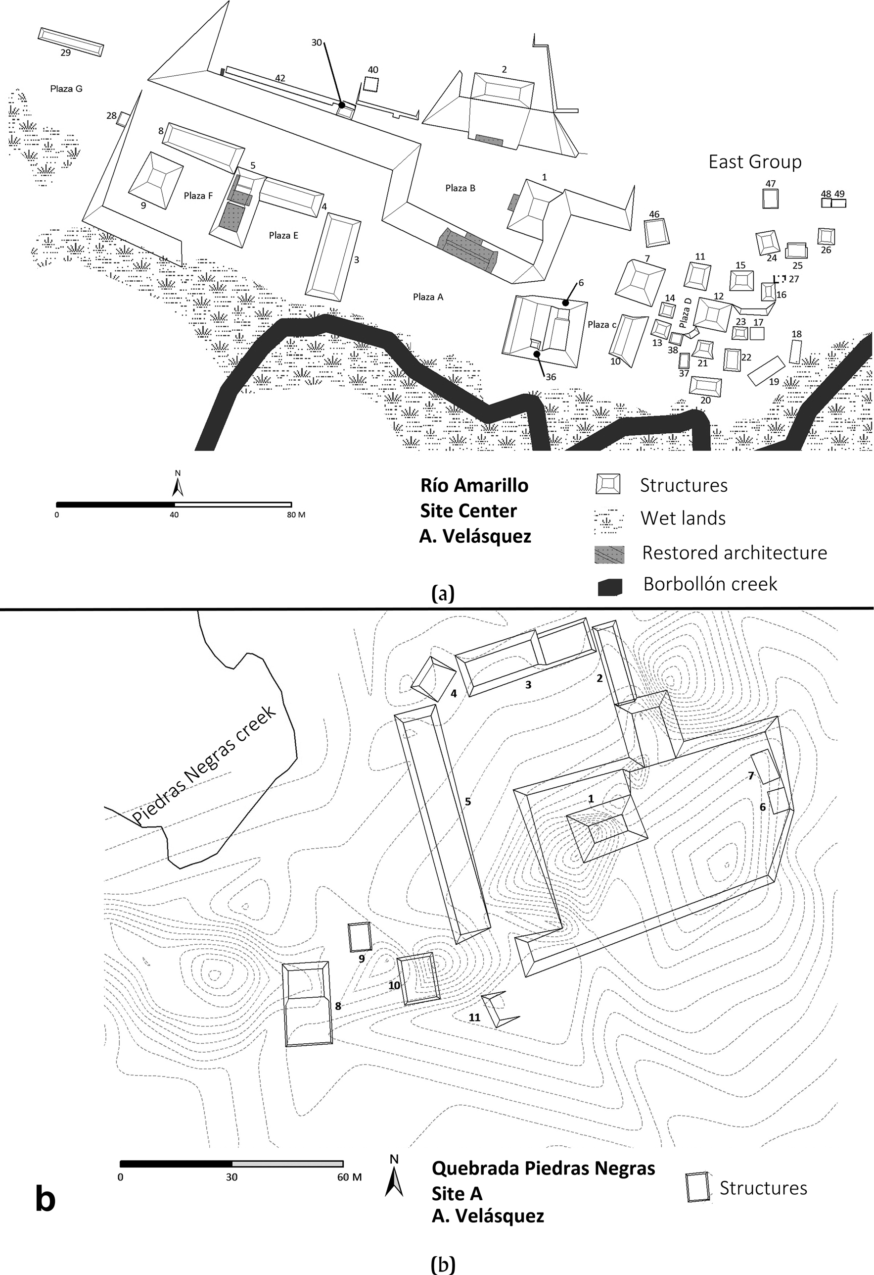
Figure 3. (a) Site layout of Río Amarillo. (b) Site layout of Quebrada Piedras Negras. Maps by Antolín Velásquez.
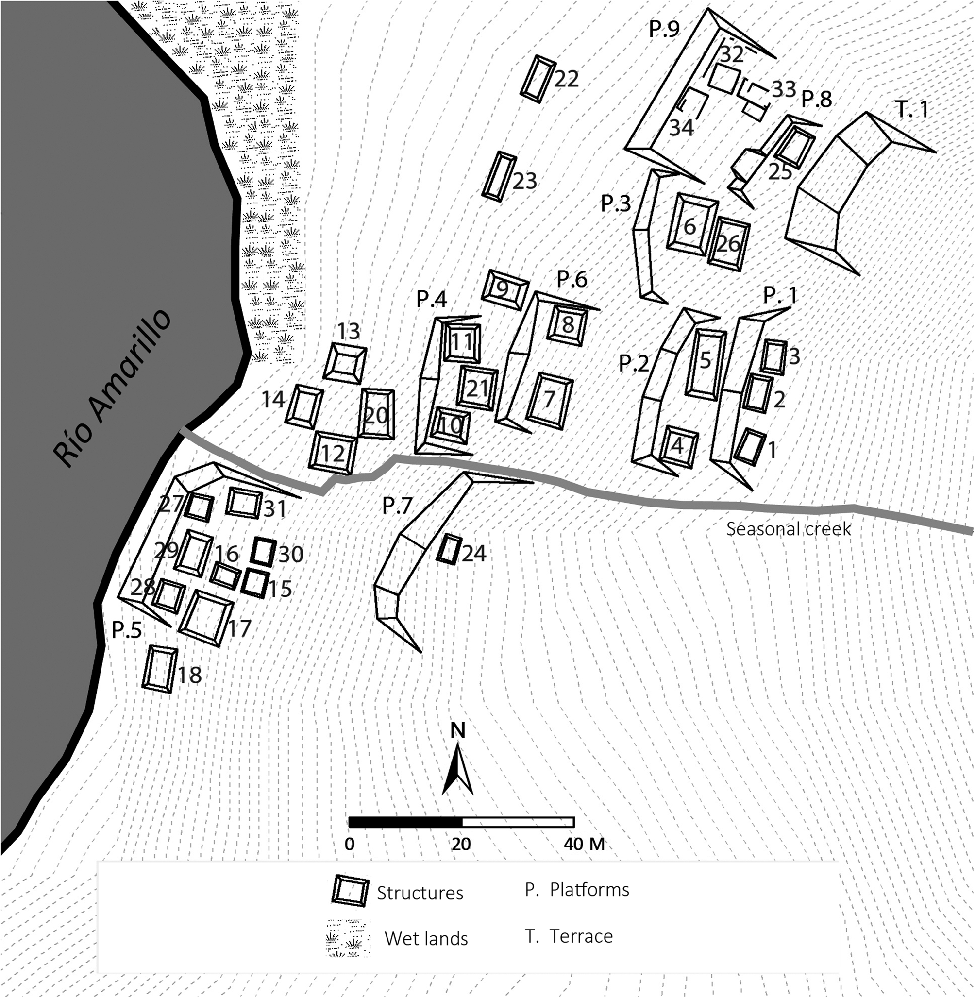
Figure 4. Site 5. Map by Antolín Velásquez.

Figure 5. Sites mapped by Proyecto Arqueológico Río Amarillo, Copan (PARAC) in the Rio Amarillo East Pocket. Map by Antolin Velásquez.
The Río Amarillo East Pocket lies approximately 20 km northeast of Copan (Figure 2). It may have been a stopping point for travelers going to the site of El Paraíso and then on to Quirigua (Barrios et al. Reference Barrios, McNeil, Díaz, Arroyo, Méndez and Ajú2018), but it also lies on the road to El Puente (Figure 1), another secondary center of Copan (Nakamura et al. Reference Nakamura, Aoyama and Uratsuji1991). Its strategic location would have made it a valuable point of control for goods coming from Maya sites such as Quirigua, and also from diverse cultures located in the interior of Honduras in areas such as the Sula Valley, Naco Valley, Comayagua Valley, and Lake Yojoa, where the large pre-Columbian site of Los Naranjos is located (Figure 1). Vessels, mold-made figurines, whistles, and metates from these Honduran regions (Beaudry Reference Beaudry1984; Gerstle Reference Gerstle1988; Hendon et al. Reference Hendon, Joyce and Lopiparo2014; Schortman et al. Reference Schortman, Urban and Ausec2001; Spink Reference Spink1983) likely passed through El Puente, before moving through Río Amarillo and into Copan, but food resources grown in the Río Amarillo East Pocket may have been more important to the support of the Copan polity.
A Valley Pocket with Abundant Natural Resources
The climate of the Río Amarillo East Pocket is currently much wetter than the Copan Pocket, receiving on average more rain annually (Figure 2; Turner et al. Reference Turner, Johnson, Mahood, Wiseman, Turner and Poole1983:54, Figure T-13). While pine and oak trees grow in the hills as they do in the Copan Pocket, this area also contains a remnant of a cloud forest, Cerro Negro (Komar et al. Reference Komar, Arce, Begley, Castañeda, Eisermann, Gallardo and Marineros2006), as well as a rain forest, El Gobiado (House et al. Reference House, Rivera, Vilchez, Soler, McNeil and Barrios2012), which would not be possible in the environs of the Copan Pocket. Both were likely far larger during the pre-Columbian period. This pocket is the only place in the valley where these forest types are found and would have provided the polity inhabitants with access to greater overall biodiversity, including some highly valued items of trade. For example, cloud forests are the habitat of the quetzal bird, whose feathers were synonymous with wealth and power in pre-Columbian Mesoamerica, adorning royalty and elites.
The Río Amarillo River, as well as the smaller rivers and streams that feed into it such as the Río Blanco, the Quebrada Borbollón, and the Quebrada Piedras Negras, and some less permanent water sources, would have been equally precious for the production of agricultural foods to send to the burgeoning population to the west. The Río Amarillo East Pocket contains two natural ponds, the Laguna de Las Sierras and the Laguna Especial, both of which are older and deeper than any other bodies of water in the valley. Sediment from the bottom of a core taken from the Laguna de Las Sierras has a conventional radiocarbon age of 8320 ± 40 BP (Beta-167235; organic sediment; δ13C = −23.9%), and calibrated dates of 7512–7302 cal b.c. (p = .856), 7228–7193 cal b.c. (p = .067) and 7284–7254 cal b.c. (p = .031). All radiocarbon dates reported in this article were calibrated at 2σ with the program IntCAL20 (Bronk Reference Ramsey2009; Reimer et al. Reference Reimer, Austin, Bard, Bayliss, Blackwell, Bronk Ramsey, Butzin, Cheng, Edwards, Friedrich, Grootes, Guilderson, Hajdas, Heaton, Hogg, Hughen, Kromer, Manning, Muscheler, Palmer, Pearson, van der Plicht, Reimer, Richards, Scott, Southon, Turney, Wacker, Adolphi, Büntgen, Capano, Fahrni, Fogtmann-Schulz, Friedrich, Köhler, Kudsk, Miyake, Olsen, Reinig, Sakamoto, Sookdeo and Talamo2020). Sediment from the base of the Especial core had a conventional radiocarbon age of 11,870 ± 30 BP (Beta-491220; organic sediment; δ13C = −26.4%), and calibrated dates of 11,771–11,657 cal b.c. (p = .552) and 11,845–11,779 (p = .402) cal b.c. The Laguna de Las Sierras is fed by two deep springs, which would not have been impacted by a drier climate.
Settlement Pattern of the Río Amarillo East Pocket
PARAC mapped 12.35 km2 of the Río Amarillo East Pocket, identifying 63 sites and test-pitting 50 of them. Based on their location, 34 sites have been assigned to the secondary center of Río Amarillo, 23 to secondary center of Quebrada Piedras Negras, and 6 to other population entities known as La Leona and Gotas de Sangre/El Gobiado (Figures 2 and 4). The sites of Río Amarillo and Quebrada Piedras Negras have a dispersed settlement pattern with a relatively low level of structures when compared with the Copan Pocket, which has 142 structures per km2 and 3,441 mounds identified in an area of 24 km2 (Fash Reference Fash1983:399; Freter Reference Freter, Schwartz and Falconer1994). Río Amarillo and its associated sites encompass an area 6 km2 and contain 225 structures; in other words there are 37.5 structures per km2. Quebrada Piedras Negras encompasses 3.70 km2 and has 125 structures, amounting to 33 structures per km2.
The Río Amarillo East Valley Pocket experienced a dramatic population increase in the Late Classic period. Based on an analysis of pre-Columbian ceramics found in test pits excavated by PARAC, 33 of the 50 sites were first occupied in the early part of the Late Classic period (a.d. 650–750) and the area reached its peak population during the Late Coner phase of the Late Classic period (a.d. 750–820) when 41 of the sites were occupied. Of these, 39 continued to be used in the Postclassic period, supporting a level of resilience undocumented elsewhere in the valley.
THE CENTER OF RĺO AMARILLO
Archaeologists have previously excavated the secondary center of Río Amarillo (Organización Integral de Desarrollo de Honduras 2010; Pahl Reference Pahl and Pahl1987; Saturno Reference Saturno2000). Pahl (Reference Pahl1975), Vlcek (Reference Vlcek1978), Gonlin (Reference Gonlin, Schwartz and Falconer1994, Reference Gonlin, Douglass and Gonlin2012) and Freter (Reference Freter, Schwartz and Falconer1994) all conducted mapping in this pocket, and the latter two also excavated some of the groups outside of Río Amarillo, as has PARAC (Figure 5). Pahl (Reference Pahl and Pahl1987:Figure 6) dug deep test pits into the lower plazas and was able to create a site layout for the Early Classic period and to detect some earlier Late Classic structures beneath the last level of construction in Plaza A.

Figure 6. (a) Río Amarillo Altar 2. (b) Río Amarillo Altar 1. Drawings by Alexandre Tokovinine.
While the Copan Acropolis was built on the valley floor, Río Amarillo was constructed into the hill of Cerro La Canteada, placed at the confluence of the Quebrada Borbollón and the Río Amarillo River. There may be multiple reasons for this construction choice. Foremost, it is a more defensible position. The center of El Paraíso was also built on a hillside (Canuto and Bell Reference Canuto and Bell2013). Second, Río Amarillo is raised up off the valley floor protecting it from the larger annual rainfall, which sometimes inundates the areas along the river.
Researchers have mapped 36 mounds, which represent household and ceremonial structures, at the site center (Figure 3a; McNeil et al. Reference McNeil, Barrios, Burgos, Erquicia and Shibata2015; Pahl Reference Pahl and Pahl1987; Saturno Reference Saturno2000). Río Amarillo has seven plazas (A–G). The site was constructed on two levels. Plazas A, E, and F are in the core ritual area on the lower level. Off to the east of Plaza A lies the East Group (EG), a residential area of tightly spaced groups.
An impressive stairway connects Plaza A to Plaza B, which composes the core ritual area on the upper level. Structure 1, a pyramidal platform once capped by a building, is found on the eastern side of Plaza B. To the north of Plaza B is Structure 2, the valley's tallest pyramidal platform found outside of Copan's Acropolis (Saturno Reference Saturno2000:157), although some of its height was achieved by taking advantage of the naturally elevated topography. Structure 2 is faced with cut-stone blocks, which once held a building with a foundation of river cobbles and walls of bajareque (wattle-and-daub). Directly west of Structure 2 lies a cut-stone block faced platform (the West Platform) with a stairway connecting its surface to Plaza B. West of the platform there is a 42-m wall made of river cobbles stacked approximately 1.2 meters thick. Even though it is located on a promontory that varies in height, the top of this wall maintains a consistent level, with the wall measuring from 0.4 to 1.1 m high to compensate for changes in the landscape. It appears to have served as the foundation for a secondary wall of bajareque, which rested on top of it. The remains of the wall lead to the end of a promontory that overlooks the entrance to the site. It may have been meant to add protection for the upper section of the site, but the fact that it does not continue on the western side of the promontory is confusing. Ceramics found along the northern side of the wall date it to the Late Classic period.
Controlling Hinterland and Rural Resources: The Late Classic at Río Amarillo
By the onset of the Late Classic period, the presence of Copan is visible at this site in the introduction of new architectural styles, inscribed altars, iconography, ceramics, and Ixtepeque obsidian. There are two periods when Copan's presence is most strongly apparent, one at the beginning of the Late Classic period—most likely during the reign of Ruler Twelve (but possibly beginning during the reign of Ruler 11)—and a second during the reign of Ruler 16.
Connections between Copan and Río Amarillo in the Early Late Classic Period
The West Platform was constructed at the beginning of the Late Classic period. It is faced with cut-stone blocks and has a seven-stepped stairway following an architectural style more reminiscent of Copan than of Río Amarillo, where structures were predominantly produced of river cobbles. A radiocarbon assay on a section of charred botanical material from the platform's base produced a conventional radiocarbon age 1370 ± 30 BP (Beta-468575; charred wood; δ13C = −24.5%) and calibrated dates of 604–685 cal a.d. (p = .872) and 743–760 cal a.d. (p = .063) and 766–773 cal a.d. (p = .02). Ceramics from the Early Classic period at Copan are from the Acbi ceramic phase, and those of the Late Classic period are from the Coner ceramic phase. The transition between Acbi and Coner occurs between a.d. 600–650 (Andrews and Bill Reference Andrews, Bill, Wyllys Andrews and Fash2005). Ceramics from a level above the base of the West Platform are a mix of Early and Late Coner phase pottery.
Structure 2 appears to have been constructed at the same time as the West Platform. Copan Ruler 11, K'ahk’ Uti’ Chan, who reigned from a.d. 578–628, or his successor Ruler 12, K'ahk Uti’ Witz’ K'awiil, could have undertaken these monumental constructions at Río Amarillo.
Inscriptions found on Late Classic altars at Río Amarillo also tie these monuments to the beginning of the Late Classic period. Altars 1 and 2 were placed in Plazas A and B. Each bears a hieroglyphic inscription but no other hieroglyphic inscriptions in stone have been found at Río Amarillo. These would appear to be the work of the Copan center. Both of the altars have been damaged over the years complicating their translation and analysis. Schele (Reference Schele1987) and Riese (Reference Riese, Boone and Willey1988) published preliminary observations on the hieroglyphic texts on the altars. The surviving fragment of the text on Altar 2 (Figure 6a) mentions the death of an individual with a Copan emblem glyph, whose name resembles those of Copan Rulers 11 and 12. It is unclear, however, whether the text contains an unusual spelling or refers to an altogether new member of the same royal house.
Altar 1 provides a clearer connection to Copan's Ruler 12. The better-preserved inscription on Altar 1 (Figure 6b) contains a Copan-style haab +1 Calendar Round (Tokovinine Reference Tokovinine2010) that falls on a number of Gregorian dates in the seventh and eighth centuries (Riese Reference Riese, Boone and Willey1988:87; Schele Reference Schele1987). The date of a.d. 643 is the best option because part of the narrative on the altar overlaps with the text on Copan Stela 10 that describes baktun mid-station rituals in a.d. 633 (Schele Reference Schele1987). The text on the altar also mentions a “western kaloomte’ of Wiinte’ Naah”. This title usually refers to the Copan dynastic founder, K'inich Yax K'uk’ Mo’, but its context on the altar is unclear because that side of the monument sustained the most damage. The ownership of the altar is ascribed to a certain “youth K'esem Taaj,” the son of a three-k'atun Copan lord. Ruler 12 of Copan was indeed close to his third k'atun of life at that time, although Stuart's (Reference Stuart2007a) reconstruction of his possible birth date in a.d. 604 implies that Ruler 12 was less than two years short of that age grade in a.d. 643 (Franco Reference Franco2019). Regardless of the identification of the protagonist's father as Ruler 12, the significance of the inscription is that Río Amarillo was governed in the seventh century by a junior member of the Copan royal house.
Connections between Copan and Río Amarillo Towards the End of the Classic Period
Ruler 16, Yax Pahsaj Chan Yopaat, likely commissioned the last level of buildings in Plaza A—Structures 3, 5, 8, and 9 (Saturno Reference Saturno2000). Canuto and Bell (Reference Canuto and Bell2008) suggest that there was a disruption in Copan's power over El Cafetal and El Paraiso when the thirteenth ruler, Waxaklajuun Ubaah K'awiil, was decapitated by K'ahk’ Tiliw Chan Yopaat, the head of the vassal state of Quirigua in a.d. 738. PARAC is still exploring whether a similar disruption may have taken place at Río Amarillo. Whether or not this is the case, during the reign of the sixteenth ruler a revitalization of Copan's connection to Río Amarillo can be found in the construction of the cut-stone block architecture in Plaza A. The exterior of at least one of these buildings, Structure 5, was composed of ornate mosaic sculptures.
Ruler 16 and the Glorification of the Founder of Copan's Classic-Period Dynasty
Structure 5, first excavated by Pahl (Reference Pahl and Pahl1987) bore iconography associated with Teotihuacan and K'inich Yax K'uk’ Mo’. Figures dressed as Teotihuacan warriors adorned the building along with crossed bundles motifs, and a war serpent shield similar to the one held by K'inich Yax K'uk’ Mo’ on Altar Q and Structure 10L-16 at Copan (Fash Reference Fash2011:163). Saturno (Reference Saturno2000) uncovered Witz masks designating this building as a sacred mountain. Sculptural elements identical to those of Structure 5 can be found on Copan Structure 10L-16, Structure 10L-22, and Structure 10L-26, as well as Structure 10L-29 in Group 10L-2 (the Royal Palace Complex at the southern foot of the Acropolis), suggesting that sculptors from the polity center produced this building façade during the reign of Ruler 16 (Saturno Reference Saturno2000). Copan's investment at Río Amarillo demonstrates the importance this area held for the polity. In addition to a possible reference to the founder of Copan's Classic-period dynasty on Altar 1 and clear references to him on Structure 5, researchers found yet another representation in the EG.
The East Group, Río Amarillo
The East Group (EG) off to the side of Plaza A is composed of six residential courtyards (Plaza D, and Patios A–E) in a style similar to the neighborhood of Las Sepulturas, which is located just to the east of Copan's Principal Group, but the Río Amarillo neighborhood is much smaller and the quality of its material culture less fine. The platforms within the EG, which are predominantly made of river cobbles (with a scattering of cut-stone blocks), exhibit evidence of wattle-and-daub superstructures and are smaller in size than the cut-stone faced structures of Las Sepulturas.
The EG settlement style and architecture appears to be Maya, with some adaptations that may be rooted in the earlier Preclassic valley traditions. The most notable of these architectural elements is a series of small ramps produced from clay unsupported by any stones (Figure 7) found in Patio C. Archaeologists have also found earthen platforms (of various design) unsupported by masonry at Preclassic sites in the Copan and El Paraíso Valleys (Manahan and Canuto Reference Manahan and Canuto2009), although no ramps have been documented. This series of sloping earthen terraces led to a platform which holds Structures 15 and 16. Of these, PARAC excavated only Structure 15.

Figure 7. Profile of ramp-connecting Structures 15 and 23, Patio C of the East Group, Río Amarillo. Drawing by Luis Canán.
The design and artifacts associated with Structure 15 suggest that it was the nexus for ritual practices in the EG, and that it may have been the home of a ritual practitioner. A front staircase consisting of three steps allowed entry into a room with a simple masonry bench of river cobbles. The interior contained artifacts associated with ritual activity: three alujadores (wide, smooth river stones, which locals say were used to flatten the leaves of tobacco for cigar production) and a quartz pendant. Both quartz crystals and cigars are widely associated both prehistorically and enthohistorically with Maya ritual practitioners and curing rites (Brady and Prufer Reference Brady and Prufer1999; Davis-Salazar and Bell Reference Davis-Salazar, Bell, Laporte, Escobedo, Arroyo and de Suasnávar2000; Groark Reference Groark2010; Hull Reference Hull, Loughmiller-Cardinal and Eppich2019).
Structure 15 recalls Structure 12 at Joya de Ceren in El Salvador (Figure 1), which researchers have also proposed as the home of a diviner (Sheets Reference Sheets2002). Each of these structures has the largest amount of spindle whorls (possibly indicating female ritual activity) in their respective sites. Scattered around Structure 15 are pieces of broken figurines and censer fragments including pieces of a censer lid in the form of K'inich Yax K'uk’ Mo’ (Figure 8a). Censers were commonly smashed as part of Maya rituals. This one ended up on the southwestern corner of the structure at the end of its use life. The censer lid, while not as finely produced, is similar in form to a censer lid of K'inich Yax K'uk’ Mo’, with the goggled eyes of Tlaloc, which was found smashed outside of Ruler 12's tomb in the Copan Principal Group (Figure 8b; Fash Reference Fash2001:107). The presence of this censer demonstrates that inhabitants of the EG also revered the founder of the Copan Classic-period Maya dynasty, and that the iconography broadcasting his power in the Río Amarillo East Pocket was not limited to the elite ritual core of Río Amarillo. The sherds in the layers of sediment associated with the censer fragments are Late Coner (a.d. 750–820).
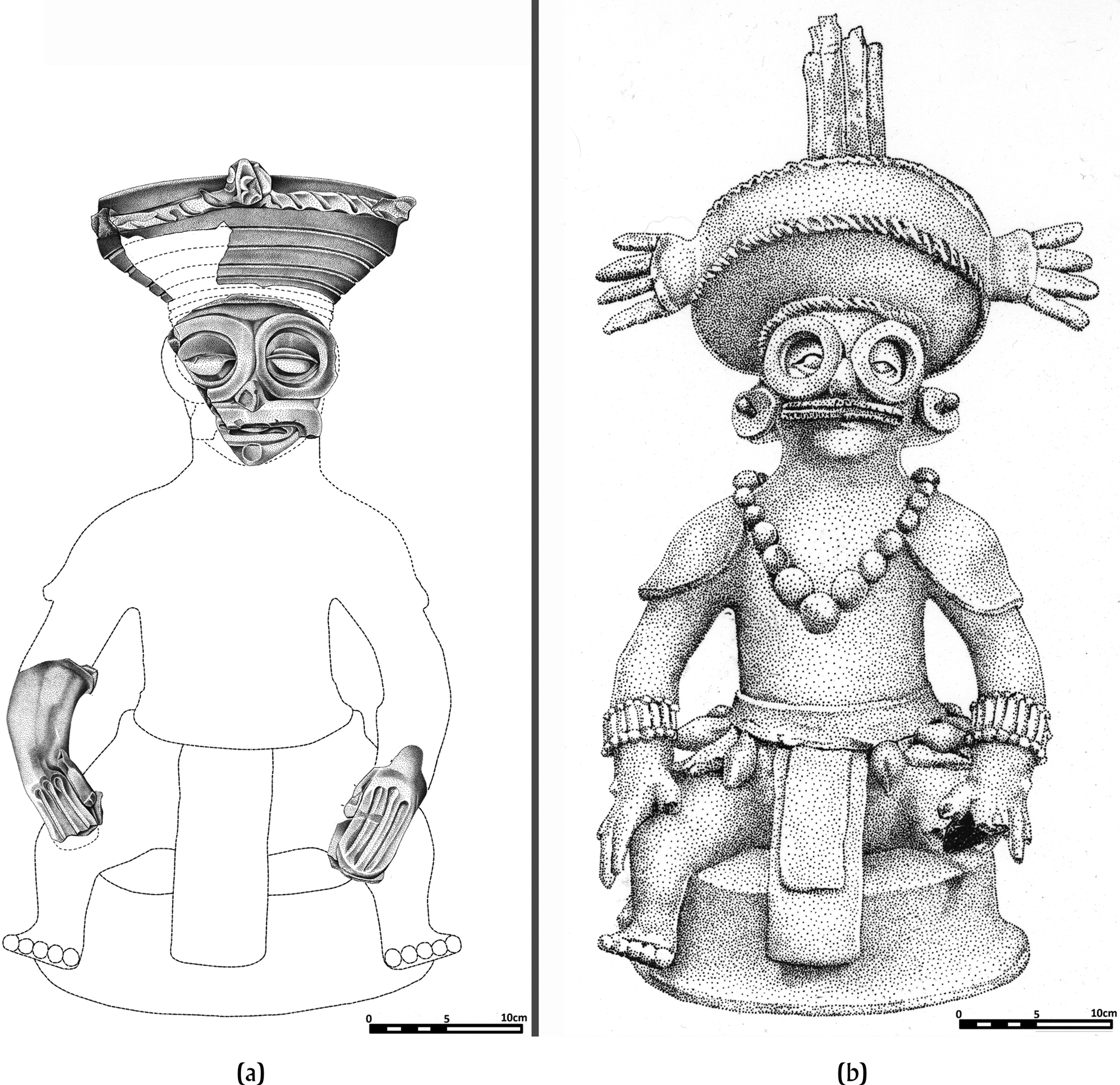
Figure 8. (a) Censer lid from Structure 15. Río Amarillo, Copan Valley. Drawing by Elvin Arias. (b) Censer lid from Ruler 12's tomb from the Copan Acropolis. Drawing by Eliud Guerra.
Late Classic Material Culture at Río Amarillo and Site 5
The analysis of obsidian and ceramic artifacts from Río Amarillo and Site 5 reveals economic connections between these sites and Copan. Although some ceramic artifacts were traded along networks independent of the Copan center, lithic artifacts demonstrate that the Río Amarillo East Pocket inhabitants had access to various types of microcrystalline silicate nodules that provided them with some self-sufficiency when it came to stone tools, including weapons.
Obsidian
Beyond sculptural and other cultural affinities, Río Amarillo was tied into an obsidian blade-core exchange almost certainly controlled by elites in the Copan center during the Late Classic. PARAC's research supports Aoyama's (Reference Aoyama1999) argument for a Classic-period state-controlled distribution of Ixtepeque blade-cores. Río Amarillo was a participant in it, although perhaps in a less direct way than the more closely positioned subsidiary-groups, such as Las Sepulturas and Rastrojón (Figure 2). Blade sizes and obsidian debitage ratios at Río Amarillo resemble those from Group 9N-11 at Las Sepulturas, which is significant because small quantities of production debitage from around platforms, ritual caches of production debitage, and platforms likely used for blade production, make 9N-11 a good candidate for a blade producing group in close proximity to the Copan Acropolis. Nevertheless, slightly smaller average blade sizes and a higher frequency of used macrodebitage at Río Amarillo suggest that residents did not enjoy the same access to obsidian as households closer to the Acropolis. Interestingly, the sites situated around Río Amarillo, such as Quebrada Piedras Negras, had little access to the more massive blade-cores that were reduced at state-subsidized groups, such as Rastrojón. This pattern suggests that Río Amarillo had a much stronger connection to the center and a different politico-economic relationship with Copan than did Quebrada Piedras Negras. Río Amarillo and its other small peripheral sites reflect a sort of microcosm of the regional obsidian distributions emanating from the Copan center.
Chert, Chalcedony, and Jasper
Meissner and his team revealed Late Classic and Early Postclassic cultural patterns in their analysis of microcrystalline silicate artifacts, which include flaked cherts, chalcedonies, and jasper. The surrounding geology of Río Amarillo has a wealth of knappable raw materials in cobble form often found in eroding banks of creeks and rivers. Surveys of extant chert sources near the central area of Río Amarillo found mainly poor-quality cherts, suggesting residents may have relied on Quebrada Piedras Negras for chert acquisition and initial stages of reduction (McNeil et al. Reference McNeil, Barrios, Meissner, Velásquez, Arroyo, Salinas and Álvarez2017; Meissner et al. Reference Meissner, Marino and Gomberg2017). In all, researchers have recovered and analyzed 21,402 pieces of lithic debris from four settlements in the Río Amarillo East Pocket.
In general, settlements in the Río Amarillo East Pocket tended to have higher proportions of debitage to formal lithic tools (bifaces, knives, dart points) when compared to Late Classic centers closer to the Copan ceremonial core such as Rastrojón (Meissner Reference Meissner2018:29), indicating that they were producing these tools. Rastrojón had high proportions of formal tools compared to debitage, suggesting finished artifacts may have circulated into the site via Copan or other exchange mechanisms.
Late Classic Ceramics
The Late Classic ceramics of Río Amarillo and Site 5 were predominantly Coner, the Copan Late Classic ceramic phase. Ceramics from the Honduran Ulua/Yojoa polychrome tradition, a ceramic type imported from outside the Maya area to the east of the Copan Valley, were found in both the EG of Río Amarillo and in Site 5, although the EG had a slightly higher percentage consisting of 0.65 percent (449 sherds) to 0.43 percent (84 sherds) of the Classic-period ceramic assemblages. The percentage of Ulua/Yojoa polychromes in both areas is lower than that found in Las Sepulturas or Group 10L-2, the Copan royal palace complex (Bill Reference Bill1997). Maya ceramics imported from Peten, Guatemala, which are found in the Copan Pocket, are not found in the Río Amarillo East Pocket. Bill (Reference Bill1997) noted that Ulua/Yojoa polychromes become more common in the valley during the Late Classic period and are likely a product of increasing trade connections with this area.
Perhaps more interesting for understanding how Río Amarillo interacted with both Copan and its other neighbors was the presence of the Cafetal ceramic group, which was first identified at the site of El Cafetal in the El Paraíso Valley by Bill (Reference Bill, Canuto and Bell2005). Archaeologists have not found this ceramic type in the Copan Pocket and this likely reflects a trade interaction sphere that did not involve the polity center. The ceramic group's origin of production is still unknown, although it was likely near or in the site of El Cafetal, El Paraíso Valley, given that it comprised 50 percent of the sherds found there (Bill Reference Bill, Canuto and Bell2005). Cafetal ceramics were found in the Río Amarillo East Pocket during the Late Classic through to the Early Postclassic (a.d. 900–1100) period. Out of an assemblage of more than 10,149 Late Classic sherds in the EG of Río Amarillo, 11.38 percent were from the Cafetal Group, while at Site 5, out of more than 5,241 Late Classic sherds, 12.25 percent were Cafetal. These ceramic types were largely composed of jars and small serving bowls.
Signs of Destruction and Collapse at Río Amarillo
The site of Río Amarillo shows signs of burning and destruction at the end of the Classic period in keeping with a similar pattern at the Copan urban center (Fash et al. Reference Fash, Andrews, Manahan, Demarest, Rice and Rice2004). Structure 2, the highest in the site, had sections of barro quemado (“burned earth,” normally from wattle-and-daub structure walls) on its surface and the area behind it to the north had a substantial portion of burned earth with surviving wood impressions, suggesting that the highest structure was scorched and fell backward. The wattle-and-daub upper wall of the long wall west of the West Platform was also burned and fell forward.
Clear signs of Late Classic/Terminal Classic destruction are less easy to discern in the EG. However, Structure 26, a residential building in Patio D, had the remains of an elaborate Ceiba censer adorned with thorns smashed down its front steps (Figure 9). The Ceiba pentandra tree holds ritual significance for the Maya and is often depicted as a World Tree. Censers of this style have been found in the Copan Pocket (see Willey et al. Reference Willey, Leventhal, Demarest and Fash1994:183, Figure 117), and Ceiba censers of various styles are common throughout the Maya lowlands (Rice Reference Rice1999). This censer may have been destroyed during the same event that felled Structure 2 and the upper section of the West Wall. Unlike the incomplete and highly fragmented K'inich Yax K'uk’ Mo’ censer lid, the Ceiba censer was nearly complete and appeared to be resting in the place where it had initially been smashed.

Figure 9. Ceiba thorn censer from Structure 26, East Group, Río Amarillo, Copan Valley. Drawing by Elvin Arias. Photograph by Walter Burgos.
The Postclassic ceramic assemblage excavated by PARAC from the EG is small, consisting of only 227 sherds (none of which are Cafetal), with 31 percent of them concentrated around Structure 15. One Postclassic figurine head found in the debris of Structure 15 resembles figurines from the Late Postclassic (a.d. 1300–1523) Roble phase of the Naco Valley (Schortman and Urban Reference Schortman and Urban2011:1, 201, Figure 8.6), suggesting that people remained in the area who remembered this structure's importance as a locus of ritual practice and returned there to make offerings for hundreds of years.
SITE 5, E TURTAR INB'UTZ: SIGNS OF RESILIENCE
Small house mounds once connected Río Amarillo to another site 200 m away on the north side of the hill called Site 5, which contains at least 33 structures (McNeil et al. Reference McNeil, Barrios, Burgos, Erquicia and Shibata2015, Reference McNeil, Barrios, Burgos, Velásquez, Díaz, Goodwin, Johnson and Figueroa2021). Data from its upper section support a thriving, uninterrupted occupation at least from the Late Classic through the Early Postclassic period (Figure 4). Most of Site 5 is built into a steep incline. Boxes of river cobbles were used to anchor the structures into the hill (McNeil et al. Reference McNeil, Barrios, Burgos, Rodríguez, Macario, Landau, Bracken, Maher, House, Wolf, Iliam Rivera and Soler2012), a practice found at other Maya sites within the valley and at the site of El Paraíso (Canuto and Bell Reference Canuto and Bell2013:9). While the entire hillside was used during the Late Classic period, the focus of Postclassic activity is higher up. This may have been a defensive choice.
Architecture at the site mixes Maya-style construction with some elements found in El Salvador and further east in Honduras. For example, Platform 4 holds a Late Classic structure that had earthen-stepped terraces with river cobble retaining walls (Figure 10a). Although it is only a modest residential building, the style of this platform recalls the large pyramidal platform of Los Naranjos's Structure IV (Figure 10b; Barrios et al. Reference Barrios, McNeil, Burgos, Landau, Macario, Ramírez, Bracken, Arroyo and Salinas2013; Baudez and Becquelin Reference Baudez and Becquelin1973; McNeil et al. Reference McNeil, Barrios, Burgos, Velásquez, Díaz, Goodwin, Johnson and Figueroa2021).

Figure 10. (a) Reconstruction of Structure 10, Site 5, Río Amarillo East Pocket, Copan Valley. Drawing by Walter Burgos Morakawa. (b) Los Naranjos Structure IV. Photograph by Edy Barrios.
Platforms 1, 2, 3, 8, and 9, as well as Terrace 1, are further up the steep slope of the hill in Site 5 (Figure 4). This area contains structures with an uninterrupted occupation stretching from at least the Late Classic to the Postclassic period. Terrace 1, which was devoid of artifacts but held deep sediments, may have functioned as a kitchen garden. Early Classic ceramics were found in one test pit and on Platform 1, but the majority of the material culture came from the Late Classic, Terminal Classic, and Postclassic periods. We excavated over 60 percent of Platform 9 with a grid of 70 2 × 2 m units. These excavations found three small structures and two retaining walls on the north and west ends of the platform (Figure 11). What remained of these structures were river cobbles resting on earthen floors. We recovered more than 10,000 ceramic sherds that largely comprised utilitarian forms, including comal fragments with layers of burned food remains. The platform held 60 projectile points of chert or obsidian, and microdebitage, flakes, and cores.
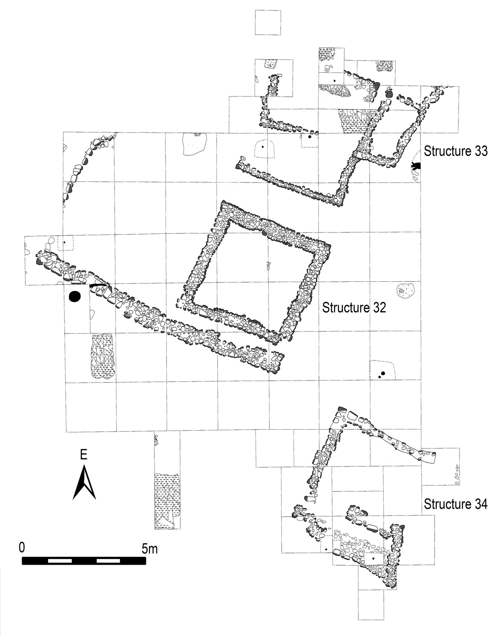
Figure 11. Plan view of Structures 32, 33, and 34 at Platform 9, Site 5, Río Amarillo East Pocket, Copan Valley. Drawing by Luis Canán.
A ramp paved with small stones connected Platform 9 to Platform 8 (Figure 12a). An Ulua polychrome vase of the Travesia Bombero type (Figure 12b; see Joyce Reference Joyce2017:Figure 17), was offered in its center. This vessel type was produced from a.d. 650–750 (Rosemary Joyce, personal communication 2017). Unlike the one found in the EG, this ramp was not stepped and recalls constructions at the site of La Florida, La Venta Valley (23.5 km to the northeast of Río Amarillo; Nakamura et al. Reference Nakamura, Aoyama and Uratsuji1991) and others at Quelepa in El Salvador (Andrews Reference Andrews1976).

Figure 12. (a) North profile of the ramp at Site 5, Río Amarillo East Pocket. Drawing by Luis Canán and Jacob Welch. (b) Ulua cylinder used as offering. Drawing by Elvin Arias.
South of the ramp on Platform 3 lies Structure 6, which is particularly instructive for demonstrating the uninterrupted occupation of this area from the Late Classic through to the Postclassic period. The southwest corner of Structure 6 had an offering beneath it, which consisted of two nested Late Classic bowls belonging to the Coner ceramic phase: a small jar resting in a red-on-orange Chilanga bowl (McNeil et al. Reference McNeil, Barrios, Bill, Burgos, Macario, Arroyo and Salinas2013). Another offering was left on the stairway of the building in a termination ritual. A greenstone axe was placed on the steps with two cut-stone blocks resting over it (likely salvaged from the Río Amarillo center), hindering (but not entirely halting) entrance to the structure. Barro quemado was found distributed throughout the mound indicating that its wattle-and-daub superstructure was burned. We assume this happened following the termination ritual. Late Classic, Terminal Classic, and Postclassic ceramics were associated with the structure. Charcoal from the termination event returned a conventional radiocarbon age of 940 ± 30 BP (Beta-468576; charred wood; δ13C = −26.8%), which calibrated to 1028–1172 cal a.d. (p = .954). The offering on the stairs suggests that the departure of the inhabitants was planned.
Excavations of Platform 1's Structure 1 and 2 recovered primarily Late Classic, Terminal Classic, and Postclassic ceramics (with a small amount of Early Classic ceramics). Structure 2 held the remains of a round oven with charred bones (likely animal) inside (Carolyn Freiwald, personal communication 2014). The conventional radiocarbon age of charred wood from the oven was 960 ± 30 BP (Beta-468573; δ13C = −24.6%), which calibrated to 1025–1159 cal a.d. (p = .954), suggesting that Platform 1 was abandoned at the same time as Platform 3.
Postclassic Material Culture
The Postclassic material culture reveals changes wrought by a resilient community adapting to a different life within the Copan Valley. Although the range of obsidian types are the same at Site 5 during the Postclassic, some Pachuca from highland Mexico is found, suggesting participation in long-distance trade networks. More intensive localized production of chert and jasper tools also begins in the Early Postclassic, which suggests a departure from earlier segmentary production techniques involving multiple centers (Meissner et al. Reference Meissner, Marino and Gomberg2017). Changes in the projectile point technology, including the adoption of the bow-and-arrow, likely related to shifts in food acquisition as demand for hunting increased in forested areas. The utility of the bow-and-arrow for local defensibility can not be ruled out. The majority of ceramics found at Site 5 in the Postclassic period are not the same as those favored in the Copan Pocket during the same period, and many are likely of local production. This suggests that, for the most part, the individuals of the Río Amarillo East Pocket were not engaging in the same trade networks as the populations that reinhabited the Copan Pocket and that the people of the Río Amarillo East Pocket were more self-sufficient.
Postclassic Obsidian
The obsidian practices changed drastically after the collapse of the Copan state. The inhabitants no longer produced blades but instead scavenged debitage to make flake cores and bifacial projectile points. Site 5 has a small percentage of blades made of obsidian from the Pachuca source in highland central Mexico, which must have been imported from the Pacific or Caribbean coasts during the Postclassic. It remains to be determined if Mexican obsidian arrived from the north or southwest, but given the trade connections between Chichen Itza and central Mexico during the Terminal and Early Postclassic, a Caribbean origin may be more likely.
Postclassic Chert and Jasper Artifacts
The onset of the Early Postclassic period reveals a dramatic change in raw microcrystalline silicate procurement for Río Amarillo residents, including the use of Type A chert (a chemically distinctive chert with chalky weathering) and increased use of Type B jasper (yellow brown with chalcedony inclusions). These changes at Site 5 represent a shift in local procurement and may reflect exchange networks broadening out from the Río Amarillo East Pocket. Type B jasper may have been available in the vicinity of Quebrada Piedras Negras, whereas the source area of Type A has yet to be identified. Such changes in procurement have not been found in Early Postclassic contexts at sites closer to Copan like Rastrojón (Meissner Reference Meissner2018). Additionally, the Postclassic contexts of Site 5 indicate more intensive on-site reduction with complete sequences of biface reduction and thinning present (Meissner et al. Reference Meissner, Marino and Gomberg2017). At this time, smaller lithic projectile points appear in small frequencies, likely indicating a technological change to the use of the bow-and-arrow. Such changes, however, do not appear to have replaced dart and spear points entirely as such tools continued to be manufactured at Site 5.
Postclassic Ceramics
The Postclassic ceramic phase in the Copan Pocket is called Ejar (Bill Reference Bill and Braswell2014; Manahan Reference Manahan2003). Ejar-phase ceramics were found in limited amounts in the El Paraíso Valley (Canuto and Bell Reference Canuto and Bell2008), but are rare in the Río Amarillo East Pocket. The ceramics of the Río Amarillo East Pocket are dissimilar enough to warrant a different name, which will follow once more analysis is completed. Cafetal ceramics made up 0.66 percent (282 sherds) of the assemblage of more than 11,553 Postclassic sherds at Site 5, so while this ceramic type was still being acquired by the occupants of the Río Amarillo East Pocket, they were more reliant during the Postclassic on what were likely locally produced wares.
DISCUSSION
The Río Amarillo East Pocket provides insight into the societal transformation experienced by a hinterland center and the rural groups scattered around it from the Late Classic through the Early Postclassic period. Here we can see a process of the control, collapse (of the secondary center), and resilience of many of the groups surrounding it. Archaeologists have not found Postclassic resilience among the inhabitants in the area immediately surrounding the Copan urban center which was abandoned for decades following the collapse (Manahan Reference Manahan, Stanton and Magnoni2008).
The architectural forms, iconography, limited hieroglyphic inscriptions, and obsidian trade at Late Classic Río Amarillo evince strategies of control by Copan. As the population of commoner farmers in this pocket grew, so did the elaboration of the site of Río Amarillo. Architecture previously unknown in the pocket, such as the cut-stone block façade of the Pyramidal Platforms of Structures 1 and 2, the West Platform, and the impressive stairway that connects Plaza A and B brought some of the consequence of Copan into the hinterlands, where structures were previously made solely of river cobbles and wattle-and-daub.
Evidence supporting the dedication of Altar 1 during the time of Ruler 12, as well as a wealth of data regarding his expansionist policies (Card and Zender Reference Card and Zender2016) suggests that he was likely responsible for Copan's increasing control over the Río Amarillo East Pocket during the seventh century. The inscription on Altar 1 states that a son, possibly of Ruler 12, was in charge at the site of Río Amarillo for at least a time during this century.
A renewal of Copan's power during the reign of Ruler 16 is marked by the creation of Structure 5 (with the aid of Copan sculptors) (Saturno Reference Saturno2000), and its other contemporary, although less ornate, cut-stone block buildings. Structure 5 is defined as a sacred mountain by Witz masks and recalls the power of K'inich Yax K'uk’ Mo’ and his links to Teotihuacan, key ideological tools employed by Ruler 16 in his building program within the Copan Pocket (Fash Reference Fash2011; Maca Reference Maca, Marken and Fitzsimmons2015; Plank Reference Plank2004; Stuart Reference Stuart, Bell, Canuto and Sharer2004). This first king of the Classic-period Copan dynasty may be referenced on Altar 1, and a censer lid effigy of him found in the East Group demonstrates that its inhabitants also revered him.
The occupants of Río Amarillo were integrated into the Copan polity, but their relationship to Maya centers likely ended there. Copan's apparent strategy of control meant that residents did not receive ceramics imported from Peten, which are found in neighborhoods nearer to Copan (although are less common in the latter half of the Late Classic period) (Bill Reference Bill1997, Reference Bill and Braswell2014). They did receive small amounts of Ulua/Yojoa polychromes, which may have reached them directly through trade routes from the interior of Honduras, or which could have been gifted to them from Copan. Ixtepeque obsidian access also appears to have been doled out by the polity elites. Additionally, Río Amarillo occupants may have been restricted from holding particular elite ritual events. This valley pocket does not have a ball court, suggesting that viewing or participating in these types of rituals required traveling to the urban center of Copan.
The Río Amarillo East Pocket would have been impacted by drier regional conditions during the Late Classic, but the higher degree of rainfall and the presence of two ponds that remained wet during the Late Classic to Postclassic transition, may have made the difference in outlasting negative climatological changes. To this day, dry periods in the valley are more harshly experienced in the Copan Pocket than in the Río Amarillo East Pocket. The fertile valley floor could have remained viable for the growth of agricultural crops. Río Amarillo East's tropical rain forests and cloud forest, which may have served as resource reserves for Copan's center and supplied many other valued goods including animal pelts, feathers, medicinal plants, and possibly old-growth tropical wood for construction needs, would have been a bounty to the Postclassic population.
The burning and destruction at the site of Río Amarillo echoes similar processes found in Copan's center (Fash et al. Reference Fash, Andrews, Manahan, Demarest, Rice and Rice2004). Perhaps the local population harshly rejected control by this center when the power of Copan faltered. Unlike the inhabitants in the Copan Pocket, at least some of the people of the Río Amarillo East Pocket continued to thrive in this section of the valley for 200 or more years, moving from their role in the economic and political fabric of the Copan polity to a community freed from the need to produce significant surplus resources for Copan elites and their subordinates.
More work needs to be conducted to understand the size of the Postclassic population and to determine whether there was an out-migration to some other locations in the eleventh or twelfth century. Perhaps the occupants of Site 5 moved to another site within the pocket. The Late Postclassic figurine head found at Structure 15 suggests that at least some people remained far into the Postclassic, and that they remembered the ritual house in the East Group, and on occasion returned there to worship.
The inhabitants of the Río Amarillo East Pocket engaged in trade networks that were external to Copan during the Late Classic period connecting them to other groups who also survived in the hinterlands. This is most clearly exemplified in the presence of the Cafetal ceramic type, which is not found in Copan, and which may originate at the site of El Cafetal (Bill Reference Bill, Canuto and Bell2005). With the breakdown of the center of Copan, these ceramics continued to be used and traded in small amounts into the Postclassic period. The people who lived at Site 5 during this time were using trade networks that brought small amounts of obsidian blades from the Pachuca source in highland Mexico, as was common throughout southeastern Mesoamerica (e.g., Joyce Reference Joyce1991; McFarlane Reference McFarlane2005; Schortman and Urban Reference Schortman and Urban2011). The majority of the ceramics found at Site 5 during the Postclassic are likely of local production following Copan's breakdown.
Analysis of chert demonstrates that this material was accessible, and even abundant, in this section of the valley. Site 5's occupants were producing their own points and using both spears and bows and arrows. The accessibility of meat resources, which may have been beyond the means of rural populations during the Late Classic period, likely became more easily attainable with the loss of the elites. However, no bones survived in the burials excavated by PARAC to test this hypothesis.
CONCLUSIONS
The site of Río Amarillo was closely allied to Copan and suffered a similar end in the Terminal Classic period. At least 39 groups in the Río Amarillo East Pocket, however, continued to be occupied during the Postclassic period. All of these sites may not follow the pattern found at Site 5. Future analysis needs to move beyond reviewing the data from test pits to more extensive excavations to determine the longevity and extent of the Postclassic occupation.
Evidence from Site 5 supports a greater degree of resiliency than has been found among the Copan Pocket inhabitants. The cessation of pressure from Copan to produce surplus food may have allowed the population of the Río Amarillo East Pocket to better weather whatever stresses were occurring in the valley, including drought. The higher amount of rainfall, the presence of two ponds, the richness of resources (including forest types) and lithic raw materials, may have cushioned the experiences of these residents during the vicissitudes that caused the dramatic political and population collapse seen elsewhere in the region.
RESUMEN
Este artículo documenta la transición del período clásico tardío al posclásico en el sitio al interior de la política de Copán de Río Amarillo y un grupo residencial asociado, el Sitio 5. Durante el período clásico tardío, las evidencias indican que Río Amarillo operó como un centro administrativo para la política de Copán con el probable objetivo de asegurar el crecimiento de cultivos para la creciente población de la capital regional. En el período clásico terminal, el centro de Río Amarillo, al igual que el de Copán, fue incendiado, saqueado y en gran parte abandonado. Sin embargo, a diferencia de la población de Copan, algunos grupos residenciales continuaron siendo ocupados hasta el final del período posclásico temprano. Aquí nos enfocamos en el Sitio 5, el cual demuestra resiliencia, con ocupación continua hasta el siglo XII, brindando una ventana a una existencia rural, viviendo fuera de la sombra de Copán.
Diversos edificios en el centro del sitio probablemente se construyeron bajo los auspicios de las élites de Copán. Los elementos iconográficos tienen asociaciones con Teotihuacan y demuestran reverencia a K'inich Yax K'uk ’Mo’, el fundador de la dinastía Maya de Copán. La Estructura 5 tenía figuras vestidas como guerreros de Teotihuacan, motivos de bultos cruzados y un escudo de serpiente de guerra similar al que sostenía el fundador en el Altar Q de Copán. La tapa de un incensario que se encontró destrozada en la zona residencial del Grupo Este también tenía el retrato del fundador Maya de Copán.
Los habitantes de Río Amarillo y el Sitio 5 compartían muchos tipos de artefactos con Copán durante el clásico tardío. La cerámica de la Fase Coner domina, e Ixtepeque es la fuente de obsidiana más común. Sin embargo, una participación en una red de comercio exterior que pasó por alto a Copán se encuentra con la presencia del grupo cerámico Cafetal.
En el Posclásico Temprano, el Sitio 5 contiene abundante evidencia de la vida de estos habitantes rurales, quienes producían puntas de lanza y de flecha de pedernal, y reelaboraron navajas de obsidiana del período clásico y participaron en redes comerciales de larga distancia que les permitía adquirir navajas de obsidiana de Pachuca desde México. La cerámica de este período respalda el uso continuado del grupo Cafetal, pero se compone principalmente de artículos locales. Una terraza en la sección más alta del sitio contiene suelos profundos y pocos artefactos, suponemos que contenía un pequeño huerto.
Pozos de prueba realizados en 25 grupos en Río Amarillo contienen cerámica del clásico tardío hasta el posclásico. Es posible que todos estos sitios no representen una ocupación ininterrumpida durante estos períodos.
Varios factores pudieron haber ayudado a los habitantes rurales del Posclásico a sobrevivir en comparación a los que se encontraban más cerca del centro: la distancia de los habitantes de Río Amarillo con Copán; la mayor precipitación anual; la diversidad de recursos naturales que incluyen un bosque lluvioso tropical y un bosque nuboso; y las dos lagunas más grandes del valle. Estos recursos pueden haber amortiguado la vida de estos residentes durante las vicisitudes que provocaron el dramático colapso político y poblacional de los centros, particularmente si la sequía tuvo un papel en este evento.
ACKNOWLEDGMENTS
We thank the Instituto Hondureño de Antropología e Historia for their support, in particular Eva Martinez and Hector Portillo, who encouraged us to work at the site of Río Amarillo, and Fernando Lopez and Eliud Guerra for their continued assistance. Our work was supported by National Science Foundation Grant #1431002, and by PSC-CUNY Awards (#64507-00 42, #68813-00 46, and #60826-00 48). This research could not have been accomplished without the talented PARAC laboratory technicians at CRIA, the excavators and excavation assistants, and the PARAC laboratory director, Jackeline Quinoñez. We appreciate the time that Samuel Pinto, Agapito Carballo, Cassandra Bill, and Paola Torres contributed to ceramics analysis. Silvia Elías, Lindsay Powel, Mark Marino, Aileen Fernandez, Courtney Powel, Amanda Regensburger, and David McCormick assisted with the analysis of lithics. Antolín Velásquez López and Justin Bracken produced maps for PARAC. Students from the City University of New York and the Universidad Nacional Autónoma de Honduras, Tegucicalpa helped both in excavation and laboratory analyses. We are thankful that John Alonzo Bodden Figueroa and Polly Smyth journeyed to Copan to help with extracting sediment cores. We also thank the community of La Castellona for their assistance. John Byram, William L. Fash, Barbara Fash, Jacob Welch, Marshall Becker, Ellen E. Bell, and three anonymous reviewers provided important comments on this article, and Bruce Bruschi and Lauren Marra provided invaluable publishing assistance.


