


INTRODUCTION
An abundance of evidence shows that territorial disputes fundamentally shape relations among states. For instance, territorial disputes are known to increase states’ chances of militarily clashing and the conflicts that result are often more severe (Hensel Reference Hensel and Vasquez2000; Reference Hensel2001; Holsti Reference Holsti1991; Kocs Reference Kocs1995; Luard Reference Luard1986; Senese Reference Senese2005; Vasquez Reference Vasquez1993; Reference Vasquez1995). In fact, Gibler (Reference Gibler2012) provides evidence that even the well-known democratic peace is actually a territorial peace. Disputed borders are also found to depress international trade flows (Simmons Reference Simmons2005) and to affect foreign direct investment flows (Lee and Mitchell Reference Lee and Mitchell2012). In sum, there is no shortage of evidence that territorial disputes are important to understanding international relations. While it is clear that disputed borders are associated with a wide range of adverse outcomes, we know comparatively little about their origins. This article begins to fill the gap in the literature by providing theory and broad-based evidence that explains the origins of contemporary territorial disputes.
Prominent ideas about what drives territorial disputes mostly focus on characteristics like natural resources that confer value to states. However, geographers have long argued that the historical status of territory is an important factor driving what territory states dispute (Hill Reference Hill1945; Murphy Reference Murphy1990). While political scientists have recognized the importance of historical status in territorial disputes (Goertz and Diehl Reference Goertz and Diehl1992; Kocs Reference Kocs1995) and measured various aspects of it (Hensel and Mitchell Reference Hensel and Mitchell2005; Huth Reference Huth1996), much remains to be learned about the role of history in general and its central role in the emergence of disputes in particular. Examination of prominent territorial claims suggests the need to put emphasis on the role of historical boundary precedents in claim emergence and also indicates the limits of a focus on features that make territory “valuable.” For instance, Ecuador’s former territorial claim against Peru did not neatly enclose oil resources near the border and missed at least a third of oil deposits close to the border. Moreover, there was no claim against Colombia despite a large oil deposit just a few kilometers across that border (Murphy Reference Murphy1990). If Ecuadorian leaders’ objective was to draw a claim to enclose economically valuable oil deposits, they did a poor job. Rather, the Ecuadorian claim followed historical precedent set by a former Spanish colonial boundary. The argument and evidence we put forth here suggest that the Ecuador-Peru case is typical of broader patterns. We argue that neighbors dispute territory when competing historical borders provide precedents to which leaders can tie prospective claims.
A key reason leaders draw territorial claims along historical precedent is because such claims are easier to justify both internationally and domestically. Accordingly, when a state’s boundaries are near competing historical precedents, as in the Ecuador-Peru case, this provides leaders with increased opportunity to make claims. If leaders can argue that they are reclaiming the historically “correct” border, this justification is much more palatable to domestic and international audiences than arguments that emphasize the need for more land, population, or resources. Moreover, drawing a claim along an identifiable linear frontier, i.e., an historical boundary, helps leaders demonstrate that they have limited aims, whereas claims that cite the need for land, people, or resources do not. However, the idea that precedents facilitate justification does not explain why leaders would want to prospectively integrate neighboring territory bounded by historical precedent.
We identify two main possibilities for why leaders have incentive to claim territory along historical precedents. First, consistent with the conventional wisdom, it is possible that leaders dispute along historical boundaries because these lines are systematically located in areas of value to states. Thus, leaders continue to pursue the same territories that states sought historically because they are strategically located or contain valuable prizes such as militarily and economically important iron ore deposits. In this explanation, the historical boundaries themselves are not central to why leaders want the territory in question. A second and more novel possibility is that historical precedents are the source of incentive for leaders that claim territory along them. Building on the institutional theory of borders, this explanation posits that leaders have incentive to dispute along historical precedents because old borders have persistent effects on behavior even after formally removed from the map. Old borders’ persistent coordination effects make integration of territory along well-established historical precedents significantly less costly and less uncertain in terms of consequences. Consequently, historical precedents “stand out” to leaders and make attractive potential claims compared to claims with no precedent.
In this article, we provide the first broad evidence that most contemporary territorial disputes arise directly from historical border precedents as well as evidence over why states claim precedents. To measure historical border precedents, we introduce new data on the density and variability of borders between the Peace of Westphalia (1648) and the French Revolution (1789). We use these data to measure the proximity of old boundaries to contemporary international borders after the Congress of Vienna (1815), which allows us to empirically assess the connection between pre-1790 historical border precedents and territorial claims after 1815. We provide evidence that leaders systematically claim territory bounded by precedents. To distinguish between the two explanations for why leaders have incentive to claim along historical lines, we perform a number of tests. First, we control for spatial variation in economic development, the presence of resources and military utility, as well as key geographic factors. We also test for an interaction between spatial variation in territorial value and the presence of historical precedents. Furthermore, we use variation in the origins and histories of border precedents that helps us distinguish between the two explanations for why leaders have incentive to dispute along historical precedents. The results overwhelmingly suggest that leaders’ incentives to dispute along historical precedents are the result of boundaries’ persistent effects on coordination and not simply the product of perpetual conflict over territories of relative economic or military value.
The remainder of the article proceeds as follows. In the next section, we situate this article in the literature, specify two explanations for why territorial claims follow precedents and outline their divergent empirical expectations. Then, we describe the research design and data that we use to measure boundaries and boundary changes pre-1790, and the information we use to measure territorial claims after 1815. Next, we present results from analysis of two measures of the emergence of territorial claims, and provide additional tests of our theory by exploiting theoretically salient variation in the origins of historical boundary precedents.Footnote 1 We conclude the empirical sections with brief discussion of the historical precedents that fueled territorial dispute between Soviet Russia and Poland after World War I. Finally, we summarize our contributions and provide suggestions for future research.
OLD BORDERS AND TERRITORIAL CLAIMS
The vast majority of research on territory and conflict examines either how territorial disputes affect militarized conflict (Hensel Reference Hensel and Vasquez2000; Holsti Reference Holsti1991; Kocs Reference Kocs1995; Luard Reference Luard1986; Vasquez Reference Vasquez1993; Reference Vasquez1995), or how disputants manage and potentially resolve their claims (Hensel Reference Hensel2001; Huth and Allee Reference Huth and Allee2002; Huth, Croco, and Appel Reference Huth, Croco and Appel2011; James, Park, and Choi Reference James, Park and Choi2006; Mitchell Reference Mitchell2002; Mitchell and Hensel Reference Mitchell and Hensel2007). Despite this literature’s clear demonstration of the centrality of territorial disputes to patterns of conflict and cooperation, we have comparatively little evidence about the origins of territorial claims.
As making claims carries significant costs, leaders are quite selective in staking claim to a neighboring state’s territory. Accordingly, the relatively small set of claims made by leaders tend to be the most credible and attractive territorial claims out of the infinite set of potential claims. We argue that the set of potential claims that leaders find attractive and plausible are bounded by two key factors: the opportunity and incentive to make a claim.Footnote 2 First, leaders are attentive to how other international actors and their own domestic audience will react to a claim. Claims that are not seen as credible or justified by the leaders of third states or that do not resonate with a leaders’ domestic constituency carry higher costs and are much less attractive. Second, leaders are also attentive to how attractive a potential claim is to prospectively integrate into their territory. For instance, what are the economic, political, or military implications of redrawing a state’s boundary around a given territorial claim?
Historical Precedents and the Opportunity to Make Claims
Claims that are bounded by an identifiable frontier and have a well-accepted justification signal that a leader is not expansionist and dangerous for regional stability and security. Accordingly, most leaders try to make clearly bounded claims with plausible justification to signal that they are not an expansionist or unlimited aims type (Goemans and Schultz Reference Goemans and Schultz2014). Claims that are tied to specific historical precedents aid leaders in demonstrating that territorial demands are bounded by clear limits. Drawing claims along an historical precedent provides a linear bound on a claim, whereas justifications based on factors like ethnic kin or military utility do not clearly imply a single linear boundary (Carter Reference Carter2016). For example, ethnic groups intermingle and are never perfectly separable by a linear boundary, which means any line will necessarily still leave populations on the “wrong” side (Carter and Goemans Reference Carter and Goemans2011). Furthermore, claims are costly (e.g., Vasquez and Henehan (Reference Vasquez and Henehan2001) or Simmons (Reference Simmons2005)) and to make a credible claim leaders heavily invest in the specifics of a given argument over why their position on a claim is “right.” The costs make it difficult for leaders to develop one claim and then quickly discard it in favor of another. This helps clarify why claims are highly selective in terms of the territory they enclose, tend to last a long time before resolution, and are empirically rare.
In addition to the strategic reasons undergirding claims tied to historical precedent, historically justified claims are often viewed as more legitimate by other states. Following the Peace of Westphalia, states’ justifications for territorial claims began to reflect the salience of territorial sovereignty that had become the basis for the international state system. Territorial claims were commonly grounded in the principle of sovereign rights and almost always made reference to how the territory in question historically belonged to the challenger (Murphy Reference Murphy1990, 534–7). The historical basis for territorial claims became embedded in international law, with legal principles such as uti possidetis that reflect the importance of territories’ historical status gaining prominence (Carter and Goemans Reference Carter and Goemans2011; Huth, Croco, and Appel Reference Huth, Croco and Appel2011; Ratner Reference Ratner1996; Shaw Reference Shaw1996; Sumner Reference Sumner2004).Footnote 3 Moreover, historical justifications, such as reference to a former treaty settlement, are noted by geographers to be the most common and often the most powerful justifications for claims (Burghardt Reference Burghardt1973; Murphy Reference Murphy1990). Given the wide use of historical justifications and their integration into some of the key legal principles relevant to territorial claims, they have special appeal in the international system (Huth, Croco, and Appel Reference Huth, Croco and Appel2011; Reference Huth, Croco and Appel2012; Reference Huth, Croco and Appel2013).
Claims based on historical precedents also have appeal to domestic audiences in part because they are relatively easy to rhetorically link to national identity. When a piece of a neighbor’s territory historically belonged to a potential challenger state, or simply had not always been a part of the potential target state, a leader can more easily argue that a territorial claim is meant to retake territory that history suggests belongs to her state and people. Accordingly, beginning in the 19th century the justification of claims tied to historical precedents have many times been draped in the language of ethno-nationalism. Even if the precedents that bound claims have little to no historical connection to nationality or ethnicity leaders still often invoke national identity in discussing historical precedents. This is an important point since pre-1790 historical precedents are generally not closely tied to ethnicity.Footnote 4 However, the idea that they are is still often propagated and can be disseminated among the population via popular press (Anderson Reference Anderson1991; Deutsch Reference Deutsch1953) and schooling (Darden Reference Darden2013). The precedent cited by Romanian elites claiming Walachia, Moldavia, and Transylvania in the 1860s and 1870s as the basis for the Romanian state is a case in point. In this instance, the historical precedent of Michael the Brave was real, but its significance in terms of national identity was largely constructed (White Reference White1999, 119–35).
Historical Precedents and the Incentive to Make a Claim
The idea that areas with competing historical precedents experience more territorial claims because claims based on precedent are easier to justify raises two questions. First, why do leaders have incentive to make territorial claims bounded by precedent that, if successful, will have them integrate this territory into their state?Footnote 5 Second, provided that leaders have incentive to dispute along historical precedents, why would all precedents be equally attractive? On the first question, we provide two possible answers: (1) leaders’ incentives to dispute along precedent is a product of borders’ persistent effects on coordination and (2) perpetual conflict over valuable territory explains why lands bounded by precedents are attractive to leaders. Finally, we address the second question by outlining how variation in precedents’ histories facilitates assessment of which of these two possibilities has more empirical veracity.
The Persistent Coordination Effects of Historical Boundaries
The institutional theory of boundaries conceptualizes borders as institutions that delineate jurisdictions and, when effective, coordinate individuals’ expectations and behavior. In terms of borders’ effectiveness as institutions, a growing body of evidence shows that not all borders, or potential borders, are “created equally” (Carter and Goemans Reference Carter and Goemans2011; Owsiak Reference Owsiak2013; Schultz Reference Schultz2014; Simmons Reference Simmons2005). Rather, well-established borders are much more effective and increasingly coordinate political and economic behavior as they become better known among the local population. Once borders are in place for long enough to become well established, they coordinate individual behavior across multiple dimensions (Carter and Goemans Reference Carter and Goemans2011; Goemans Reference Goemans, Kahler and Walter2006; Simmons Reference Simmons2005). For example, economic actors build trade networks around existing boundaries because these jurisdictional lines dictate the transaction costs, e.g., tax rates or tariffs, of doing business in one locale versus another (McCallum Reference McCallum1995; Simmons Reference Simmons2005; Trefler Reference Trefler1995).
The connection between historical boundaries and subsequent territorial claims derives from boundaries’ coordination of multiple facets of economic and political behavior. Coordination around well-established political boundaries is persistent even after borders change, as it is difficult for all relevant actors to abruptly alter their economic and social behavior in accordance with new jurisdictional lines. Locally, individuals often continue to coordinate around old boundaries because their existing networks still provide economic or political incentives to do so (Gavrilis Reference Gavrilis2008). In other words, as political boundaries remain in place for a period of time and become established, they exhibit increasing returns to coordination as more and more individuals condition their behavior on them (Pierson Reference Pierson2000; Reference Pierson2004). Political boundaries are a good example of an institution that generate such increasing returns across time; their efficacy and importance increases as more individuals learn to effectively coordinate their behavior relative to them. This also makes their influence more costly and difficult to quickly reverse (Pierson Reference Pierson2000, 254). Moreover, the incentive to swiftly re-coordinate behavior on newer boundaries is significantly weakened in areas that have experienced more volatility in borders. Accordingly, well established political borders are likely to exhibit path dependence in the sense that once the population learns to coordinate around them, their effect on behavior will be quite persistent, a dynamic that is most pronounced in areas where boundaries have changed more often.
Old boundaries that are well established have especially sticky effects on behavior in areas where boundaries have frequently changed, as these frequent border changes fuel uncertainty over the permanence of a new border. This uncertainty decreases incentive to coordinate behavior around newer borders. Consequently, current border institutions are less stable and effective when they are near well-established historical precedents, an effect that is amplified when these well-established precedents are in areas that experienced a number of historical boundary changes. There is ample evidence that old boundaries continue to be remembered and to affect behavior after they are “removed from the map.” For instance, Wolf (Reference Wolf2005) demonstrates that the pre–World War I partition borders in Poland continued to be one of the best predictors of internal economic patterns during the interwar period despite the fact that they were defunct as formal institutions.
We identify two main ways in which persistent coordination around well-established historical lines fuel territorial claims along historical precedents. First, persistent coordination around old borders and the accompanying uncertainty in border regions where significant portions of the population are not conditioning behavior around new borders often leads to disputes and conflict at the local level that can escalate to the national level. The existence of disagreement and dispute among the population in the border region provides impetus and incentive to states to make territorial claims along established precedents. For example, local disputes over jurisdictional issues at the Sino-Vietnamese border in the mid-1950s directly led to the involvement of the two national governments and confusion and disagreement at the local level contributed to subsequent claims over the border.
As early as November 1956, questions arose at local levels regarding the management of certain border areas lying between China’s Guangdong and Guangxi Provinces and Vietnam’s Hai Ninh, Lang Son, and Cao Bang Provinces. Although the nature and scope of the dispute has never been disclosed, presumably it resulted from the ambiguous delineation of administrative responsibilities. Consultation between local representatives of the two sides inevitably touched upon the boundary issue, which they could not resolve, and the matter was referred to central authorities for consideration (Chang Reference Chang1985, 21).
Confusion over the location of the border derived in part from competing precedents over its location. China and France signed a border agreement in 1887 that drew a new boundary, which was again modified in 1895 (Day Reference Day1987, 309–10). Additional adjustments were made between the French and Chinese as a result of trade agreements (Day Reference Day1987, 310). However, locals were not accustomed to coordinating around the boundary identified by the 1887 agreement or any of the subsequent agreements although some functions did slowly begin to correspond to the latest frontier. In the end, there was considerable uncertainty among the population over the true location of several portions of this 1,200 kilometer border, which led to incidents such as construction projects by the Vietnamese on the “wrong side” of the boundary (Chang Reference Chang1985, 20–2). Although this border was relatively peaceful at the time of the first known local incidents in 1956, formal claims were made by both China and Vietnam in 1976 and the two states fought a war in part over territorial issues three years later (Chen Reference Chen1987; Duiker Reference Duiker1986).Footnote 6
A second and more general reason why persistent coordination around established precedents fuels territorial claims is that these historical boundaries are relatively attractive for leaders to prospectively integrate into their own state.Footnote 7 As more of the population living near the border coordinates their behavior around an historical precedent, the cost of implementing the precedent as a “new” boundary lowers.Footnote 8 State administrators enjoy significantly lower transaction and adjustment costs, as arrangements and local institutions that many already have experience with can be revived and reused (Carter and Goemans Reference Carter and Goemans2011). Along these lines, Wolf, Schulze, and Heinemeyer (Reference Wolf, Schulze and Heinemeyer2011) argue that post-WWI treaties were not as disruptive to trade in central Europe as most presumed because the new borders were drawn around prior trade district borders that shaped existing trade patterns. A growing body of evidence from political science also demonstrates that the integration of new territory along pre-existing international lines leads to a much more stable and effective boundary (Huth, Croco, and Appel Reference Huth, Croco and Appel2011). For instance, territorial settlements that follow historical precedent are less prone to subsequent dispute and conflict (Carter and Goemans Reference Carter and Goemans2011; Reference Carter and Goemans2014; Prorok and Huth Reference Prorok and Huth2015) and are significantly less disruptive of trade flows (Carter and Goemans Reference Carter and Goemans2015; Wolf, Schulze, and Heinemeyer Reference Wolf, Schulze and Heinemeyer2011). The idea that historical precedents have persistent effects on economic and political behavior makes sense of these empirical findings and importantly also suggests a novel mechanism behind why leaders have incentive to dispute along precedents.
This theory provides us with clear expectations over where leaders will dispute historical precedents and what types of precedents leaders will tend to claim. First, it is clear that well-established historical boundaries are especially attractive to leaders as potential new boundaries. Historical boundary precedents can only have persistent coordination effects if they were in place long enough to coordinate behavior in the first place. Thus, we expect a precedent that was an international border for 40 or more years to have greater effects on behavior than a precedent that was in place for five years. Accordingly, we expect the link between historical precedents and territorial claims to be strongly conditional on whether there are precedents that were international borders long enough to become well-established institutions. Second, coordination on well-established precedents will be especially persistent in areas that experience multiple boundary changes. Numerous boundary changes generate uncertainty over both function and the probability that any new border will remain in place in the long run. The Sino-Vietnamese example illustrates this dynamic, as the French and Chinese changed the location of the boundary several times in ways that confused a significant portion of the local population and impeded recoordination on one of the newer lines. In sum, we expect areas that have better established precedents and that have experienced more variability in historical boundaries to be especially prone to territorial claims.
The idea that well-established boundaries exhibit increasing returns to coordination suggests that their effects on behavior are difficult to quickly reverse. However, over longer periods of time the effects of even well-established historical precedents should wane as newer boundaries become more familiar and generational changes slowly erode the effects of precedents. Moreover, leaders whose states are potential targets of territorial claims have incentive to try to consolidate their current borders, which can help to speed the process by which influential precedents wane in importance. It is important to emphasize that leaders are strategic in their consolidation of border regions and have incentive to work particularly hard to integrate areas that are at high risk for claims. Thus, our argument implies that leaders will focus on border regions where portions of the population continue to coordinate behavior along historical precedents rather than the current boundary (Aleprete Jr. and Hoffman Reference Aleprete and Hoffman2012; Carter Reference Carter2010). This is especially true in Europe starting the early 19th century, as a heightened need for a steady stream of taxes, conscripts and materials pushed states to implement more direct rule over their citizens and control over their territories (Dincecco Reference Dincecco2011; Dincecco, Federico, and Vindigni Reference Dincecco, Federico and Vindigni2011; Hoffman and Rosenthal Reference Hoffman and Rosenthal1997; Karaman and Pamuk Reference Karaman and Pamuk2013; Tilly Reference Tilly1992, 114–126). States employ a variety of tactics to try to push more of the population to coordinate around the current border. For example, the Vietnamese used forced migration of ethnic Han populations at the Chinese border in the late 1970s in an attempt to consolidate their border region (Chang Reference Chang1985), while many European states in the mid-19th century used literacy and education (Anderson Reference Anderson1991; Darden Reference Darden2013; Deutsch Reference Deutsch1953) in addition to repression (Downing Reference Downing1992) to bolster national loyalties and consolidate territorial control. The idea that persistent coordination is central to the emergence of territorial disputes suggests that states will work particularly hard to consolidate their borders in areas with well-established historical precedents. Moreover, state efforts should be especially pronounced in areas that have experienced more variability in borders historically as these are the areas we expect the coordinative effects of well-established precedents to be especially persistent.
In sum, the view that persistent coordination around historical precedents provides incentive to make territorial claims implies that the attractiveness of these precedents to leaders decreases with their age for two related reasons. First, the attractiveness of all established historical precedents slowly wanes with age as the population changes in the border area and new borders slowly become familiar. Second, the waning effect of historical precedents should be quickened in areas especially ripe for claims, i.e., with high historical border variability, due to states’ strategic efforts to consolidate new borders and stave off or weaken claims. Accordingly, we expect claims to be less attractive in areas with older precedents and also expect the negative effects of precedent age to be greater in areas with greater variability in historical borders.
Alternative Sources of Incentive: Historical Boundaries and Valuable Resources
Our empirical expectations are different if perpetual conflict over areas that are particularly valuable provide incentive for leaders to make claims along precedent rather than persistent coordination effects. If historical precedents reflect border changes that are the result of perpetual conflict over valuable land, the presence of territory of special economic or military value should be central to whether or not a given historical precedent is attractive to a leader. Thus, the inclusion of key measures of whether territory has especially valuable characteristics should account for subsequent claims and subsume any effect of there being competing historical precedents. Moreover, if historical precedents still play a role in facilitating justification but incentive derives from the fact that precedents enclose sought-after resources, there should be interactive effects between measures of territorial value and the presence of historical boundaries. Finally, the idea that the propensity for military conflict plays a central role in the link between historical precedents and territorial claims is also consistent with the idea that states perpetually fought over these valuable lands historically and continue to do so in later periods.
The conventional wisdom that states draw territorial claims to enclose the territories with the highest economic, political or military value also leads to very different expectations over how variation in the histories of precedents affects subsequent claims. First, the presence of more historical precedents in particularly valuable areas should reflect very frequent and spatially concentrated border changes that result from continual disputation by states. This implies that precedents in these areas are not in place long enough to become well institutionalized. Second, the age of an historical precedent is not significant to why leaders have incentive to dispute it under the perpetual conflict explanation. Rather, it is the valuable resources that the territory contains which provides the incentive to make claims. Moreover, perpetual conflict over valuable territories implies that the spatial distribution of precedents would be correlated across historical periods in the areas dense with precedents and subsequent claims.
RESEARCH DESIGN
Assessment of the influence that historical borders have on territorial claims is a nontrivial task, as it requires new data on the location of all relevant historical international borders. Moreover, care is needed in choosing the period to measure historical boundaries in as well as the subsequent time period to examine how these precedents affect the emergence of territorial claims. We focus on historical boundaries and subsequent territorial claims in Europe.
A focus on Europe has several advantages. First, the advent of the modern system of territorial states occurred in Europe in the 17th century and subsequently spread (or was exported) to other regions of the globe. Specifically, scholars typically point to the 1648 Treaty of Westphalia, which ended the Thirty Years War, as marking the advent of the modern sovereign state.Footnote 9 A focus on historical borders in Asia, the Western Hemisphere, or Africa during the 17th and 18th centuries would provide less variation in historical boundaries, as the territorial state became the dominant form of political organization significantly later in those regions. Furthermore, Europe’s status as the region that “birthed” the modern territorial state makes the findings of our study relevant to the rest of the world, as we might expect similar patterns elsewhere during later periods.
Accordingly, we measure historical precedents with data on all European borders after 1650, just subsequent to the Peace of Westphalia and up until 1789, which marks the start of the French revolution. A focus on the period from 1650 to 1789 has several advantages. First, it allows us to analyze the role of international borders that existed during the initial periods of state formation under the Westphalian model. Second, it facilitates the analysis of all territorial claims after the Congress of Vienna (1815). For the last several decades, the field of international relations has focused on international conflict, territorial claims, and numerous other topics from 1816 onwards, which facilitates comparison of our results to those in the existing literature.
An additional advantage to measuring historical boundaries prior to 1790 is that we largely sidestep objections that these historical borders are simply picking up the distribution of nationalities or ethnic groups. The earliest historical period commonly used to discuss the beginnings of nationalism is the start of the French Revolution, which is subsequent to our measurement of historical borders. In any event, Weber (Reference Weber1976) shows that even in France, the country most often identified with the emergence of nationalism, a coherent national identity did not fully develop until the spread of railroads and national publications facilitated increased interaction across regions and localities in the 1870s (see also Anderson (Reference Anderson1991) and Sahlins (Reference Sahlins1989)).Footnote 10 Of course, leaders might often use nationalism and ethnic identity in making territorial claims after 1815 (as discussed above); however, these pre-1789 historical boundaries have little to do with the distribution of nationalities.Footnote 11 We provide several robustness checks in the Online Appendix that help demonstrate this empirically.
DATA
Our research design requires data on the history of European state boundaries between 1650 and 1789 and territorial claims in Europe after 1815. We create our theoretically key independent variables using newly collected data on the existence and shape of European states (Abramson Reference Abramson2016). To measure territorial claims after the Congress of Vienna, we use the Issues Correlates of War (ICOW) data (Hensel Reference Hensel2001; Reference Hensel2013).
Territorial Changes in Europe
Our main variables of interest capture the density and variability of political boundaries after Westphalia and before the French Revolution. To measure these outcomes we use data collected by Abramson (Reference Abramson2016) that describes the existence, location, and boundaries of every European state before 1790. These data define states based upon the Weberian definition as quasi-monopolists of violence and use three criteria to distinguish between states, statelessness, and other forms of political organization. We treat political units as territorial states if they meet all three of the following criteria:
-
1. No Direct Military Occupation
If a territorial unit is militarily occupied by a foreign power, according to this coding scheme it ceases to exist. Similarly, if a political unit successfully conquers a piece of territory, this newly occupied territory is treated as a part of the conquering state. For example, when the Ezzelino or Pallavicini families were able to effectively wield military control over several Italian city-states, they are thus coded as the amalgamation of these units into a single state.
-
2. The Capacity To Tax
The power to expropriate resources, or the ability to take from another that which she has produced or owns, is the coercive authority central to statehood. Accordingly, the capacity to tax is used as evidence of the state’s monopoly over coercion. So, for example, when Worms (1184) or Lubeck (1226) ceased to pay imperial taxes and (demonstrably) gained rights to collect taxes and tolls within their boundaries, they are subsequently treated as independent states. Moreover, this allows us to distinguish states from other forms of political organization such as Leagues that maintain a limited capacity to generate revenue. With this perspective it is apparent that the Holy Roman Empire was marked by substantial political fragmentation, capturing the proliferation of the political units that maintained “full jurisdiction. . . rights of legislation, privileges of coining money, levying tolls and (collecting) taxes (Bryce Reference Bryce1920, chap. xiv).”
-
3. A Common Executive
An important feature of a unified territorial state is sharing a common executive. Many early-modern states were composites of, sometimes, geographically and institutionally disparate groups. That is, although they shared a common executive many subnational groups maintained distinct parliaments and other subnational institutions granting particular rights and prerogatives to certain regions or groups and not to others. For example, although they belonged to the Spanish state Castile, Aragon, Valencia, and Navarre maintained distinct parliamentary bodies each with separate and distinct political and economic rights. When there exist semiautonomous groups like this that share a common executive we treat them as a single state, as long as they also satisfy the prior two criteria.
We use this definition of what political units are considered territorial states in post-Westphalia Europe to identify the relevant set of historical boundaries. The data describing international boundaries for all states in post-1650 Europe are measured in five year panels and are taken from a number of sources. We use Geographic Information Systems (GIS) to measure the density and variability of international boundaries, as the location of boundaries is inherently spatial. Two of the main sources from which the GIS boundaries are constructed are the Centennia Historical Atlas (Reed Reference Reed2008) and the Euratlas Digital Atlas (Nussli Reference Nussli2010). The Nussli data is measured in one-hundred year panels whereas the Reed atlas utilizes a much higher frequency approach, taking observations in tenths of years. The boundaries are used as defined by both datasets aligning them at every hundred-year mark based upon the coding scheme defined above. The Nussli data matches the Reed data nearly perfectly at 100-year intervals. Because the Reed data is not geo-referenced, GIS compatible shape files are built by manually constructing the boundaries from reprojected images provided by the atlas and then referencing each observation using the European Alpers Equal-Area projection system.
The Nussli data have been used in several prominent publications and are quite accurate (Stasavage Reference Stasavage2011a; Reference Stasavage2011b; Blaydes and Chaney Reference Blaydes and Chaney2012). Nevertheless, even after combining the data from these digital sources there are still a number of imperfections, for example, units coded as independent states are absent from the reconstructed shape files. These tend to be small independent principalities, ecclesiastical units, and city-states that were not picked up by the historical geographers who created the digital reproductions from which the maps are constructed. In order to rectify these flaws and prevent the potential problems that could plague any statistical analysis based on the uncorrected data, a number of historical and contemporary primary source maps are used to create high frequency boundary changes for these missing units. From this combination of secondary and primary cartographic sources boundaries for all political units that are not present on the initial maps from the Nussli and Reed data are projected that meet the coding criteria. Using known pieces of physical geography, known political boundaries, and the location of cities and towns to properly reference these maps, shape files are created that, with a high degree of accuracy, reflect the geographic scale of each unit. For each of these units the history of their boundary changes is tracked, i.e., expansions and contractions, and the shape files are adjusted accordingly.
Our units of observation are arbitrarily located 225 × 225 kilometer grid squares (approximately 50,000 square kilometers).Footnote 12 There are several important inferential and measurement advantages to the use of grid squares as a unit of analysis, which we clarify with comparison to the commonly used dyadic unit of analysis. First, the shape and location of arbitrary grid squares are not plausibly endogenous to the variety of political, economic, and military factors that determine the shape and location of a dyad’s boundary. In fact, the same reasons that make Europe the most theoretically interesting region for this study, e.g., its long history of experience with the territorial state, also elevate our concerns about endogeneity if we use post-1815 dyadic borders as our unit. It is important to note possible concerns with the grid-square approach, such as their size. If we choose grids that are too large, a grid might contain historical boundaries that are far from contemporary borders, making the association with claims in the same grid spurious. However, our grid squares are not especially large relative to the size of European states, as a 50,000 square kilometer area is similar in size to current Bosnia and Herzegovina or Slovakia.Footnote 13 This was a factor in our choice of grid-square size, with the other factors being measurement issues and the fact that making grid-square units too small can artificially decrease standard errors.
Measurement of our key variables within grid squares ensures that we do not rely too much on the precise spatial location of our historical data relative to contemporary boundaries. While our data is quite accurate, political boundaries were somewhat less precise in the 17th and 18th centuries relative to the 19th and especially 20th centuries (Biggs Reference Biggs1999; Branch Reference Branch2014). Placing historical precedents in grid squares largely sidesteps these potential pitfalls.Footnote 14 In contrast, the use of post-1815 dyadic boundaries to define our unit makes the precise spatial accuracy of all variables relative to these boundaries essential, while the grid-square units allow us to demonstrate that any results are not sensitive to perturbing the location and size of the units.
To more concretely demonstrate that the grid squares are superior in our application, we also construct all of our data using the post-1815 dyad as the unit of analysis. We are careful to construct the dyadic test in a way that shows our grid-square analysis does not suffer from several potential drawbacks. First, given that most territorial claims made by a state are proximate to its current borders, we want to ensure that our results with grid squares do not reflect historical boundary precedents that are actually far from borders, e.g., 200 kilometers, and associate these with unrelated territorial claims. To do this we create dyadic data with 50 kilometer buffer zones around each post-1815 state’s border and limit our measurement of historical boundary precedents to these areas close to current borders.Footnote 15 We replicate the analysis of our main results, i.e., Table 1 below, using the post-1815 dyad as the unit of analysis and find very similar results, which are reported in our Online Appendix. Estimation of models using the post-1815 dyad as the unit of analysis also makes possible systematic evaluation of our argument that selection on unobservables is more of a threat to inference in the dyadic analysis than the grid-square analysis. Specifically, we subject each of these approaches to the statistical test developed by Oster (Reference Oster2013), which allows researchers to evaluate the degree to which unobservable factors are likely to bias estimates of their key variable. The results, reported in the Online Appendix, suggest that the grid-square estimates are very robust to potential violations of the exogeneity assumption, while the dyadic analysis are not robust at any specification of the test.Footnote 16
TABLE 1. The Effect of Historical Borders on Territorial Claims

Notes: ***p < 0.01, **p < 0.05, *p < 0.1.
Robust standard errors in parentheses.
Using these data and the grid square as our unit we construct our primary measure of the presence of competing historical border precedents. We start by measuring the density of historical borders in each grid square in five-year panels. We use this information to create two measures. First, we create Historical Border Density, which captures the mean density of historical borders from 1650 to 1789 on a given grid-square unit. Second, we create our primary measure of competing historical precedents, Historical Border Variability, which captures temporal variation in the density of borders over the 140 years preceding the French Revolution. Thus, while the density measure identifies areas that have higher levels of average border density, the variability measure identifies areas that experience more variation in border density from 1650 to 1789.
We construct measures of border density and variability for each grid square as follows. Every five years between 1650 and 1789, for each grid-square i, we observe the length of borders within its bounds. Because there is variation in the amount of land within each grid square (some include coast) we then divide the length of borders by the area of landmass contained within each unit, yielding a measure of border density for unit i in period t, which we call Historical Border Density it . We take the mean of the measure across all t to produce our averaged measure Historical Border Density i for each unit i.
Given our measure of average Historical Border Density i , we are able to construct a measure of the variability of border density across time. A measure of border variability allows us to assess whether areas near post-1815 international borders that experienced more border changes across time, and thus have multiple historical precedents, are especially prone to territorial claims. Border variability for each territorial unit i is measured as follows:
 $$\begin{eqnarray*}
&&\text{\emph {Historical Border Variability}}_i\nonumber\\
&&\quad = \sum _{t=1}^T\sqrt{(Density_{it} - \overline{Density}_i)^2}.
\end{eqnarray*}$$
$$\begin{eqnarray*}
&&\text{\emph {Historical Border Variability}}_i\nonumber\\
&&\quad = \sum _{t=1}^T\sqrt{(Density_{it} - \overline{Density}_i)^2}.
\end{eqnarray*}$$
Thus, Historical Border Variability i effectively captures how variable borders are across time for each grid square.Footnote 17 As noted above, variability is our most theoretically important measure, as it identifies whether there are multiple historical precedents. However, Historical Border Density i is an important control variable in all of our models, as it identifies the density of state boundaries in a given grid square. Thus, inclusion of Historical Border Density i in our regression models ensures that our key measure of Historical Border Variability i does not just proxy for the density of states and borders in a given grid square. To account for the fact that Historical Border Density i and Historical Border Variability i are right skewed, we take the natural logarithm of both measures.
Given the central theoretical importance of competing historical precedents, we also develop an alternative measure that identifies each particular boundary change. To produce a measure at the grid-square level, we identify all j boundaries in a given grid square i in each time period t. We create Border Changesit by giving a value of 1 to each boundary j that changes in time period t, and a value of 0 to each boundary j that remains in place, then taking the sum across j. To create a measure of the number of historical precedents in each grid square i, we sum across t, which yields Border Changesi = ∑ T t = 1 Border Changesit . Thus, Border Changes i measures the number of historical precedents in each grid square.
Given that Border Changes i specifically identifies each boundary change, we also use it to construct measures of how long historical precedents were in place as international boundaries and how old each historical precedent is. To measure the duration of precedents as boundaries in each grid square we first calculate the amount of time each border j was in place in each grid square i. We then take the average of this measure across all borders in each grid square to produce Average Border Duration i . Given that Border Changesi measures the volume of precedents in an area and Average Border Duration i tells us how long the average border remained in place on a given unit before becoming a precedent, estimation of the interaction between Border Changesi and Average Border Duration i identifies whether leaders systematically make claims over better established precedents in areas where boundaries are historically quite variable.
Our measurement of how old precedents are in each grid square is analogous to the construction of Average Border Duration i . Specifically, for each precedent j in grid square i we calculate how many years passed between the time the border changed (and became a precedent) and 1815. Given this information for each of j precedents in grid square i, we take the average age of all precedents in grid square i to obtain Average Time Since Last Change i . To assess whether leaders systematically make claims over more recent precedents in areas with more historical boundary variability, we estimate an interaction between Border Changesi and Average Time Since Last Change i .Footnote 18
Territorial Claims in Europe
We use the ICOW data to locate all territorial claims in Europe from 1816 (Hensel Reference Hensel2001; Reference Hensel2013). These data describe the actual piece of territory that is being claimed in each dispute, but do not provide geocoding of the territorial claims. Given that we need geocoded claims to accurately assess whether they are proximate to pre-1789 historical borders, we geocode each territorial claim and assign every post-1815 territorial claim in Western Europe to grid squares.
We use the geocoded ICOW data to generate two main dependent variables that measure key aspects of the emergence of territorial disputes in Europe after 1815. First, for every territorial unit we count the number of territorial claims made on it by states after 1815. The number of territorial claims in an area is a straightforward measure of the opportunity and incentive that leaders have to dispute territory. Second, to capture how quickly territorial claims arise, we measure the amount of time from November of 1815 until the first territorial claim is made upon a given unit. The notion that more recent precedents are more attractive suggests that claims over historical precedents should be made more quickly than claims that do not follow precedent.Footnote 19
Finally, for every claim in the Hensel (Reference Hensel2001; Reference Hensel2013) dataset we record whether or not the claim follows a precedent. Since our measures of historical border variability and density are recorded up until 1790, to avoid post-treatment bias we only include historical precedents that occurred before 1790.Footnote 20 We then measure both the number of claims for which there existed previous historical precedent or not and the timing of the first claim for which there existed a historical precedent and the timing of the first claim without prior precedent.
Alternative Sources of Incentive: Measuring the Value of Territory
To assess the idea that perpetual conflict over territory of great value explains why leaders dispute along precedent, we collect several key measures of territorial value that are consistent with prominent arguments in the literature. In any event, measurement of variables that might explain both the variability in historical borders as well as territorial claims after 1815 facilitate estimation of an unconfounded relationship between historical precedents and claims.
It is plausible that territory of special economic value is more likely to be contested by states (Huth Reference Huth1996). To capture the economic potential of a given piece of territory we include three covariates measuring economic development. First, following an extensive literature in economic history we include the size of the urban population in the year 1600 living within a given unit as a proxy for its overall level of development.Footnote 21 The urbanization data are taken from the data provided by Bairoch, Batou, and Pierre (Reference Bairoch, Batou and Pierre1988) which describe the population sizes of the about 2,200 towns which at some point had 5,000 or more inhabitants between 800 and 1800. Territorial units with more urban centers and greater urban population are more economically prosperous and valuable.
Second, we include a count of the number of iron production centers taken from the exhaustive data set built by R. Sprandel on the location of iron forges in preindustrial Europe (Sprandel Reference Sprandel1968, 93–220). Iron ore production is especially important as it was a key to both industrialization and economic development and has long been a central feature of military capabilities. Iron production is central to the production of weaponry and armaments during the entire period relevant to our study (McNeill Reference McNeill1984) and is a key feature of the widely used Composite Index of National Capabilities (CINC) data (Singer, Bremer, and Stuckey Reference Singer, Bremer and Stuckey1972).
Third, given the importance of agricultural production on wealth historically, we also account for agricultural economic potential. We measure the rain-fed suitability to produce agricultural output across Europe, which captures the capacity for a given piece of territory to produce agricultural output without extensive irrigation. We derive our agricultural development data from the FAO’s GAEZ combined land suitability dataset (FAO Reference FAO2000). This data provides a good measure of how economically valuable different areas are due to their ability to produce a relatively predictable food supply.
We also account for features of natural geography that might make territory more attractive because they confer military and economic value. For instance, geographers and historians have long argued that rivers make effective and defensible borders (e.g., Keegan (Reference Keegan1994)). Hew Strachan (Reference Strachan1983, 11) notes that waterways were of vital strategic importance to advancing armies during the 17th and 18th centuries, noting the importance of rivers as defensible points. In a similar vein, Goemans (Reference Goemans, Kahler and Walter2006) details how Philip the Fair of France chose four rivers as France’s “natural boundaries” in the early 14th century. Historians such as Strachan (Reference Strachan1983) also detail rivers’ essential role in transport and communication, which makes control of rivers of significant economic value. We account for the special value attached to territory with rivers by controlling for the length of rivers within a given territorial unit.
In addition to rivers, mountain ranges have been viewed as natural frontiers that are especially defensible and valuable in border areas (Hensel Reference Hensel2001). We account for how mountainous an area with spatial data on terrain ruggedness collected by Shaver, Carter, and Shawa (Reference Shaver, Carter and Shawa2016). The ruggedness data is created by first dividing the globe into identical one kilometer by one kilometer grid squares. Second, the absolute elevation change between each grid square and all contiguous grid squares is calculated. Given a ruggedness measure for each 1 × 1-km grid square, we are able to calculate the mean level of ruggedness in each 225 × 225-kilometer grid square. This provides us with highly detailed and accurate data about the topographical features of territory that are widely thought to be important to military strategy and border formation.
We also account for a wide range of geographic features specific to each territorial unit by including measures of latitude and longitude. Controls for latitude and longitude measure any other omitted spatial variables that confer special economic, military, or political value to particular territories. We do two things with our latitude and longitude measures to ensure that our results are not affected by some omitted spatial measure of value. First, we include latitude and longitude as linear variables. While the simplicity of this approach is nice, it is possible that any omitted variables that vary spatially do so in complex and nonlinear ways across Europe. To deal with this possibility, we also estimate the effects of latitude and longitude using very flexible nonparametric regression splines. This approach allows the shapes of the effects for either latitude or longitude to take a wide range of shapes across the map of Europe. This strategy helps ensure that inclusion of latitude and longitude controls for any additional unmeasured geographic features that make territory in some regions more valuable prizes than in others.
Finally, we also construct five different measures of ethnicity for states within each grid square. For example, following Huth (Reference Huth1996) and others, we measure the number of post-1815 dyads in a given grid square in which a group has a plurality among the population of one state, but is a minority in the neighboring state. We do not find evidence that any of these measures influence our findings, so we relegate all of the details and results to the Online Appendix in the interest of space.Footnote 22
THE NUMBER AND TIMING OF TERRITORIAL CLAIMS
We begin with the effect of historical boundary variability on the total number of territorial claims made on a given piece of territory. The geographic distribution of territorial claims are mapped in the left-hand panel of Figure 1, while Historical Border Variability i is mapped in the right-hand panel. The boundaries of Europe in 1650 are also mapped in each panel. The map of Historical Border Variability i in the right-hand panel of Figure 1 demonstrates a lot of spatial variation in pre-1790 historical boundaries. It is also clear that boundaries vary in many areas relative to their starting point in 1650. From visual inspection, there is a clear spatial relationship between where historical boundaries are most variable and where more territorial claims emerge.Footnote 23

FIGURE 1. The Number of Territorial Claims across Territory (Europe (1650))
To be more systematic, we estimate several regression models to assess the effect of competing historical precedents on the number and timing of territorial claims. Table 1 shows the results of ordinary least squares and negative binomial models of the number of territorial claims. We first report simple bivariate model specifications that only include Historical Border Density i or Historical Border Variability i . Thus, models 1 and 2 only include Historical Border Density i , while models 3 and 4 only include Historical Border Variability i . Next, we include both measures in models 5 and 6. Finally, we repeat the pattern of model specification for these two variables from models 1–6 in multivariate specifications that also include all of our other measures of territorial value, i.e., models 7–12. This specification strategy helps us to demonstrate three key things about the effect of Historical Border Variability i . First, we can establish that Historical Border Variability i is not a proxy for the number of borders or states by showing that its effect is not influenced by inclusion of Historical Border Density i . Second, the inclusion of our measures of territorial value in models 7–12 helps us determine whether the effect of Historical Border Variability i in models 3–6 are a product of it being a proxy for these included measures of territorial value. Third, comparison of the coefficients in the bivariate models with those of the full models in columns 11 and 12 helps as conclude that the effect of Historical Border Variability i is not driven by systematic connection with omitted measures of territorial value. As noted by Altonji, Elder and Taber (Reference Altonji, Elder and Taber2005), comparison of the size of coefficient estimates on a variable before and after including other important covariates provides a good heuristic for whether selection on omitted variables drives an estimate.Footnote 24 Oster (Reference Oster2013) builds on this idea with a formal test of whether an estimated coefficient is robust to selection on unobservable variables, which we also implement. We take the same approach in our analysis of claim timing in Table 2.
TABLE 2. The Effect of Historical Borders on the Timing of the First Territorial Claim

Notes: ***p < 0.01, **p < 0.05, *p < 0.10.
Robust standard errors in parentheses.
Across specifications that include our measures of economic and military value we find that the relationship between the existence of multiple historical precedents and the number of territorial claims is both statistically and substantively significant. The magnitude of the effect of Historical Border Variability i on the number of claims is large, as a one standard deviation increase in this variable from its minimum increases the predicted number of claims from 0 to more than 3. Furthermore, when we include both density and variability in the same specification (columns 5–6 and 11–12 in Table 1) or include both measures along with the measures of territorial value, the estimated effect of border variability remains very similar to what it is in bivariate specifications. The robustness of the effect of Historical Border Variability i to the measure of mean density in models 5–6 and 11–12 nicely demonstrates that it does not reflect borders being more variable in some areas simply because there are more borders in these grid squares.Footnote 25 The robustness of the coefficient on Historical Border Variability i to inclusion of all other measures of territorial value demonstrates that it is not a proxy for these measures and that it is not very plausible that it is a proxy for omitted measures of territorial value (Altonji, Elder, and Taber Reference Altonji, Elder and Taber2005). Moreover, the formal test developed by Oster (Reference Oster2013) reveals that our finding is robust to the most difficult possible specification of this test.Footnote 26
The models in Table 2 represent two complementary approaches to the analysis of how historical boundary variability affects the timing of territorial claims. First, in the odd numbered columns we estimate the simplest possible model, regressing the number of months from November 1815, when the Treaty of Paris was signed, until the first territorial claim was made in a unit with OLS. However, the OLS model does not correct for grid squares that never experience a claim, i.e., right-censored units. Thus, we also estimate Cox proportional hazard models that correct for right censoring to ensure this does not bias our results. The OLS and Cox proportional hazard estimates are summarized in Table 2. Note that a negative coefficient in the OLS models indicates a variable is associated with claims being made quickly in a grid square, while the opposite is true for the Cox models where the coefficient indicates the influence of a variable on the hazard rate for claims.
The results across all 12 model specifications in Table 2 are substantively consistent with those in Table 1.Footnote 27 The magnitude of the estimates for mean density and variability are similar across the models if we only include one of these two measures, e.g., model 2 or 4, but the effect of variability is robust across all specifications while the effect of mean density washes out when we also include variability in the specification, e.g., models 11 and 12. This again nicely demonstrates that the presence of multiple historical precedents drives the emergence of territorial claims. Moreover, the coefficient on Historical Border Variability i again easily survives the formal robustness check developed by Oster (Reference Oster2013).
Several of the measures of territorial value also attain statistical significance in some specifications, although no variable is as consistently associated with claims as Historical Border Variability i . The length of rivers is positively associated with the number and timing of territorial claims, which is consistent with the notion that rivers are of economic and military value (Strachan Reference Strachan1983). Urban population is also significant in the OLS models of the number of claims, although it fails to attain significance in the negative binomial models. Urban population is also associated with quicker claims being made on a unit, although the coefficient is not always significant. Terrain ruggedness has significant effect across all specifications except the negative binomial model of the number of claims that includes all other regressors, i.e., model 12 in Table 1. We find that agricultural productivity is a significant predictor of claim timing in Table 2, but find that it has no effect on the number of claims in an area.
These results in conjunction with those of Table 1 suggest that economic and military factors do affect the number of claims, as many historians and much of the existing literature suggest. The fact that we condition on variables that measure economic and military significance and that these variables are also important makes clear that historical border variability is not just serving as a proxy for military or economic value. The latitude and longitude indicators that control for any additional features that make some territory more attractive to leaders perform inconsistently across the specifications. Moreover, the results do not change from those reported here if we estimate the effects of both latitude and longitude on claim emergence nonparametrically, which allows a lot of flexibility in estimation of the effect of being in different parts of Europe. This gives us further confidence that our results do not suffer from an omitted spatial variable that measures territorial value.Footnote 28
We also estimate interactions between each of our measures of territorial value and Historical Border Variability i to assess the idea that historical precedents provide opportunity to make a claim, while value indicators such as Iron Production provide incentive. However, none of these interactions reach statistical significance in the models of the number of claims and we only find a modest interactive effect between Historical Border Variability i and river density when we examine claim timing. This is the case regardless of whether we estimate a separate model for each interaction or if we interact each measure with Historical Border Variability i in a single model. Regardless of our approach Historical Border Variability i remains statistically significant with a substantively similar effect on the number of claims.Footnote 29
As an additional assessment of the idea that perpetual conflict over especially valuable territory drives the connection between precedents and claims, we construct a test of whether militarized conflict propensity drives the estimated relationship to Historical Border Variability i . We test this idea using the causal mediation framework developed by Imai et al. (Reference Imai, Keele, Tingley and Yamamoto2011), which allows us to statistically identify whether the effect of historical borders on the number and timing of territorial claims is mediated by an intervening post-treatment variable, in this instance post-1815 militarized conflict. We operationalize the observed propensity for conflict as the the count of militarized interstate disputes taking place within each of our grid squares after 1815.Footnote 30 If the effect of Historical Border Variability i operates through MID propensity, then we will observe a large mediating effect of MIDs and a diminution of the direct effect of historical variability. However, the estimated direct effect of Historical Border Variability i on the number and timing of claims is essentially identical to what we find in Tables 1 and 2 and we find no evidence of a mediating effect through MID propensity. These results are fully described in the Online Appendix.
Historical Border Variability and Claims Drawn Along Precedent
The results presented thus far show that areas with multiple historical precedents experience a significantly higher volume of territorial claims that are made more quickly. However, we do not explicitly distinguish among claims that are drawn along historical precedents and claims that do not follow precedent in Tables 1 or 2. Thus, it is conceivable that the territorial claims made near multiple historical precedents are not actually drawn along these historical lines. To demonstrate that our findings are the result of leaders drawing claims along historical precedents, we separate claims that follow precedent and claims that do not follow precedent and replicate the main models in Tables 1 and 2. Out of the 133 distinct territorial claims in the data, 85, or around 65%, follow historical precedents.
The results when we distinguish between precedent-based claims and claims without precedent clearly demonstrate that our key findings are driven by claims drawn along historical precedent. Table 3 shows that historical border variability, our key measure of multiple historical boundaries, is strongly related to the volume of claims that follow precedent but not to claims that that do not follow precedent. Specifically, the effect of historical border variability is similar in the models of claims over historical precedents in columns 1–6 of Table 3 to what we find in the models of all territorial claims in Table 1.
TABLE 3. The Effect of Historical Borders on Territorial Claims By Precedent

Notes: ***p < 0.01, **p < 0.05, *p < 0.1.
Robust standard errors in parentheses.
In contrast to the results for claims drawn along precedent, we find that historical border variability is not systematically connected to the much rarer set of claims without historical precedent. Historical border variability loses statistical significance and importantly, also loses substantive significance when the focus is on claims without precedent. Interestingly, our control for the density of borders in an area consistently predicts the number of claims that do not follow precedent, i.e., columns 11 and 12. This suggests that claims without precedent tend to occur where there are more borders to dispute, but that the presence of multiple competing historical borders is not associated with these claims. The results when we focus on the timing of claims that follow precedent versus the timing of claims that do not follow precedent are similar and are reported in the Online Appendix.Footnote 31
INCENTIVE AND VARIATION IN THE HISTORIES OF PRECEDENTS
Thus far, our findings are consistent with the idea that persistent coordination around precedents drives subsequent claims. To recap, we find that the effect of Historical Border Variability i is not affected by the inclusion of our measures of territorial value. Moreover, we find little to no evidence of interactive effects between measures of economic or military value and Historical Border Variability i . These results weigh against the idea that perpetual conflict over the same valuable territories drives the connection between precedents and claims. In this section we explore variation in the origins and histories of precedents to provide critical tests of whether persistent coordination effects account for leaders’ incentive to make territorial claims over historical borders. Specifically, we test the claim that historical precedents are increasingly attractive when they were international borders for longer periods of time and when they were more recently removed from the map.Footnote 32 We also test the claim that persistent coordination around precedents will be stronger in areas where boundaries were more variable, as we analyze the number of historical precedents in a grid square conditional on how well established the average historical boundary was and how old the average precedent is. Our expectation is that the effect of how well established precedents are and how old they are on claims is larger in areas where boundaries have been more variable. The models with the interactions are the theoretically interesting specifications, so we focus our discussion on those.Footnote 33
The estimated interactive effects between Border Changes i and Average Border Duration i are strongly supportive of the idea that better-established precedents are more attractive, particularly in areas where borders have changed more frequently. The interaction between Border Changes i and Average Border Duration i is positive and significant in all specifications. Thus, the number of precedents increases the number of claims conditional on some precedents in a grid square being well established.Footnote 34 The negative and statistically significant interaction between Border Changes i and Average Time Since Last Change i in columns 7 and 8 are also consistent with the idea that persistent coordination effects drive claims. This indicates that the number of precedents increases the number of claims conditional on these precedents, on average, being relatively recent.
The substantive importance of both interaction effects are made clear by examining Figures 2 and 3. Figure 2 shows how the predicted number of claims from column 10 of Table 4 is influenced by increasing both the number of precedents, or Border Changes i , and the length of time these precedents were international borders, or Average Border Duration i . The four graphs in Figure 2 all allow Average Border Duration i to vary on the x axis and vary Border Changes i across the four panels. The panel on the far left depicts a grid square with one historical precedent, the second panel a grid square with five precedents, the third a grid square with 10 precedents, and the final panel on the far right a grid-square with 15 precedents.Footnote 35 The predicted number of claims is depicted on the y axis.

FIGURE 2. The Duration of Precedents as Border Institutions and Subsequent Territorial Claims

FIGURE 3. The Age of Border Precedents and Subsequent Territorial Claims
TABLE 4. Average Border Duration, Average Precedent Age and the Emergence of Claims

Notes: ***p < 0.01, **p < 0.05, *p < 0.1.
Robust standard errors in parentheses.
The graphs show that the relationship between these two variables is truly conditional in the sense that both have greater effects on territorial claims as they mutually increase. Thus, while the effect of Average Border Duration i is positive across all panels with multiple precedents, the slope of its effect increases sharply as Border Changes i increases. Moreover, the effect of Average Border Duration i is not statistically significant in the panel that depicts a grid square with one border change, while it is significant for most of its range when there were at least five precedents. Figure 2 provides striking evidence supportive of persistent coordination driving claims, as the proportion of precedents that are claimed increases sharply in Average Border Duration i in areas where there are multiple precedents. For example, when there are five precedents with an average duration of about 50 years, three of them are claimed, on average.
Figure 3, which is based on column 8, shows a similarly important interactive effect between Border Changes i and Average Time Since Last Change i . The predicted number of claims is decreasing in the average age of precedent when there are more than one of them, an effect whose slope steepens as we examine grid squares with more precedents. Again, we find no significant effect for either variable when there is only one precedent in a grid square, i.e., the left-most panel. The steepening of the slope of the effect as we examine areas with more historical precedents shows that precedents more quickly wane in attractiveness as potential claims when they are in areas where boundaries historically changed more frequently. This is strikingly consistent with our expectation that leaders focus their consolidation efforts strategically on areas that are at greater risk to experience claims.
The results in Figure 2 also imply that there are limits to how much variability historical borders can exhibit while remaining attractive to leaders. These results suggest that Historical Border Variability i , our primary variable, should start to have lesser effects on claims when variability in historical borders is extremely high, as borders would have changed too often for precedents to become well established. We explore this idea with a generalized additive model (GAM) version of the negative binomial model in column 12 of Table 1; the only difference here is that the effect of Historical Border Variability i is estimated with penalized regression splines, a flexible nonparametric approach that imposes few restrictions on the shape of the estimated effect between Historical Border Variability i and territorial claims. Figure 4 shows the estimated effect of historical border variability when we model its effect on claims with splines penalized for smoothness.Footnote 36 The plot strikingly shows how the predicted number of territorial claims increases rapidly as Historical Border Variability i increases across most of its range, and subsequently declines when past border variability reaches very high levels. It is worth emphasizing that the portion of the plot in Figure 4 that shows a decreasing effect for Historical Border Variability i represents only about 12% of the data. Thus, for almost 90% of the data, increases in Historical Border Variability i lead to an increase in claims, while the effect of past border variability is only decreasing when it reaches very high levels.
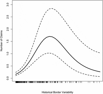
FIGURE 4. Non-parametric Estimate of the Relationship between Historical Border Variability and the Number of Claims
Finally, recall that if perpetual conflict over the most valuable territories accounts for the clustering of precedents and subsequent claims, this implies that border changes consistently occurred in the same areas over time. However, the correlations between Historical Border Variability i measured during the periods 1650–1699, 1700–1749, and 1750–1790 are quite low. The correlation between Historical Border Variability 1650 − 1699 and Historical Border Variability 1700 − 1749 is about 0.55, while the correlation between Historical Border Variability 1700 − 1749 and Historical Border Variability 1750 − 1789 is only 0.28. Thus, it is simply not the case that the same areas experienced border changes across the 140 years in which we measure historical precedents.
The results shown in Table 4 and Figures 2–4 provide evidence that persistent coordination effects drive subsequent territorial claims rather than persistent conflict over especially valuable territory. The finding that leaders make more territorial claims in areas with historical precedents that were better established as international borders and more recently became precedents is consistent with the importance of persistent coordination effects, but not of perpetual conflict over valuable territory. Moreover, there is really no way to explain the nonmonotonic effect of variability in historical borders on claims depicted in Figure 4 with the perpetual conflict explanation. Rather, the idea that border changes reflect perpetual conflict over the most valuable land suggests that the effect of Historical Border Variability i should have its largest positive effect at its highest values, which is clearly not the case.
COMPETING HISTORICAL BOUNDARIES AND THE POLISH STATE
The results above provide consistent support for our arguments across a large number of statistical tests. Here we detail an important case, that of post-WWI Poland, to demonstrate that our interpretation of the statistics is born out when we examine a case in more detail. Poland is a good case to examine because its political boundaries have varied a lot and several of the relevant historical precedents were in place for long periods of time. Furthermore, Poland’s post-1919 borders were subject to five territorial disputes, which provides an opportunity to see if these claims are tied to the existence of competing historical precedents.Footnote 37 We briefly outline the history of Poland’s boundaries and demonstrate that 20th century Polish leaders, and their opponents across the border, used historical precedents to make their cases. In the interest of space, we focus exclusively on the dispute between Soviet Russia and Poland.
At its largest, the Poland-Lithuanian Commonwealth encompassed more than a million square kilometers—nearly double the size of France. In 1795, before it was wiped from the map for the subsequent 123 years, the area contained within Polish boundaries was just over 200,000 square kilometers—or roughly the size of England. By our calculations, between 1635 and 1795, there were 12 major revisions of the territorial bounds of the Polish state. These revisions provided political actors in Poland and her competitor states conflicting precedents from which to assert rights of territorial control well into the 20th century. Furthermore, several of the precedents that historically bounded a large multiethnic Polish state were in place for long periods, which provided relatively attractive precedents to leaders staking territorial claims in the early 20th century. Depending upon which historical precedent Polish political actors chose to focus on, there existed between 386 and 203 years of union before the First Partition of Poland in 1772, a history Polish leaders could rely upon to justify claims to territory. Similarly, Russian political actors could lay claim based upon the 147 years of control which followed the First Partition of Poland. Moreover, as Wolf (Reference Wolf2005) demonstrates, these partition borders continued to coordinate local economic behavior well into the 1930s.
The events surrounding the reformation of the Polish state in 1918 highlight how the existence of precedents that were international borders for long periods led to territorial dispute between the Second Polish Republic and the Soviet Union after 1919. Following their surrender at Versailles the German armies retired from the Eastern front and the Soviets and Poles both laid claim to the former German sectors running roughly from Vilnius in present-day Latvia through the corridor running from Kiev to Lviv in Ukraine. The situation on the ground was one that is favorably described as ambiguous. Whereas Polish historiography tends to describe a Soviet invasion of Poland, Russian historians describe Polish aggression into established Soviet borders. A prominent historian notes that “the borders ‘belonged’ to nobody in 1919” (Davies Reference Davies1972, 26).
This was because once the Germans left there was no lasting, recognized, border that both parties could use to divide territory; the Soviets and Poles alike had historical precedent with which to claim territory and attempt to assert control. The Treaties of Andrusovo (1672) and “Eternal Peace” (1686) first codified the division of Ukraine between Tsarist Russia and the Polish-Lithuanian Commonwealth, awarding and then affirming control of “Right Bank” Ukraine, save Lviv, to the Poles and the rest of Ukraine to the Russians (Allen Reference Allen2014, 158; Ragsdale and Ponomarev Reference Ragsdale and Ponomarev1993, 108–110; Stevens Reference Stevens2013, 168). However, over the next century the three partitions of Poland between 1772 and 1793 gradually ceded all of this territory to Russia, making a rump Polish state that was to eventually entirely incorporated into the Tsar’s domains (Lukowski Reference Lukowski1998).
The independent state claimed by early 20th century Poles entailed recreating prepartition Poland-Lithuania. For example, Roman Dmowski, chief Polish delegate at Versailles, sought to establish a Poland along the pre-1772 partition borders. Marshal Pilsudski, head of the newly formed Polish army and future head of state similarly sought to create a multinational Polish federation along these same boundaries (Davies Reference Davies1972, 29–30; Dziewanowski Reference Dziewanowski1969, 377; Iivonen Reference Iivonen1990, 174). The Soviets, on the other hand, viewed themselves as the inheritors of the Tsarist realm and, while recognizing the inevitability of an independent Polish state, desired to base its territorial bounds on the final partition of 1795 (Davies Reference Davies1972, 295; Lieven Reference Lieven2002, 30).
A notable fact in this case is that national identity played little role in shaping these territorial claims—the geography claimed by both sides was neither Russian nor Polish but instead consisted of ethnic Lithuanians, Belorussians, Ukrainians, and Jews. Similarly, the area claimed by both the Soviets and Poles provided little in the way of natural or defensible frontiers. Not easily garrisoned, it was particularly difficult to maintain large armies in defense of this extensive border. Its railways and towns, both few and far between, made it difficult to transport men and goods across substantial distance. And lacking geographic barriers to impede the movement of armies there were few “natural” borders upon which either side could credibly make claims. Rather, both sides made claims based on competing and relatively well-established boundary precedents, which played a key role in the territorial dispute that culminated in the Polish-Soviet conflict of 1920.
CONCLUSION
We demonstrate that the proximity of current borders to competing historical precedents is central to how many territorial claims leaders make and how quickly claims are made. Our results provide consistent evidence supportive of the view that the persistent coordination effects of historical boundary precedents provide leaders with incentive to draw claims along them. Contrary to what the conventional wisdom would suggest, we find no direct evidence that perpetual conflict over areas of great value to states explains leaders’ propensities to contest territories bounded by precedent. These novel findings are important to the literatures on international conflict, territory and conflict, state formation, and represent unique and new evidence that history matters in international politics. Geographer S. Whittemore Boggs was prescient over half a century ago writing that territorial claims in Europe “arise in many instances because too much history is remembered by both parties concerned” (Boggs Reference Boggs1940, 17).
Despite the well-established and central role that territorial disputes play in international conflict, we know surprisingly little about the origins of territorial claims. Geographers and historians have suggested that historical borders play a key role in subsequent territorial claims and their justification, and political scientists have also recognized the salience of history. However, no systematic theory explains why and under what conditions leaders tie contemporary claims to historical boundaries and no general empirical evidence exists showing either that claims follow historical precedents or which historical precedents leaders tend to dispute. To our knowledge, this article provides the first evidence that the variability of historical precedents near existing borders drives the emergence of most territorial claims. We subject our findings to a number of difficult robustness tests, casting significant doubt on several plausible alternative interpretations of our results.
We focus on post-1815 Europe in this article, which is an ideal starting point given Europe’s role as the region where the territorial state became the dominant form of organization in international relations. However, our theory and findings also have important implications for other regions of the world. Given that the territorial state has been the dominant form of political organization in Europe for over three centuries, there is a rich history of boundary precedents that exhibit a lot of variation over how well-established and old they are. Although Africa, Latin America, and Asia do not have this same history, our theoretical framework can be quite useful for guiding work on the origins of disputes in these regions.
We also expect territorial claims to follow precedent in other regions of the world, in part because these precedent-based claims provide leaders with greater opportunity. A quick look at territorial claims in Asia also suggests the importance of historical precedents for claim emergence. Most prominently, the large number of border changes experienced by China throughout the 19th century, when other regional powers such as Russia were expanding and China tottering, led to a large number of Chinese territorial claims in which the Chinese cite historical precedents. Claims over Soviet territory were particularly contentious, as military conflict in the late 1960s over land of little strategic value (Huth Reference Huth1996) played a key role in the deterioration of Sino-Soviet relations. In contrast, the Thai-Burmese border did not experience multiple precedents, and these two states have not experienced territorial disputes.Footnote 38 Historical precedents also matter in Africa, as the contentious claim made by Togo against Ghana follows a pre-World War I boundary from when Germany controlled Togo.Footnote 39 This boundary became a precedent when France and Britain split Togo after 1918 and the British absorbed their portion into Ghana. While Togo’s claim is often discussed as an effort to reunite people speaking Ewe within Togo, the actual claim does a remarkably poor job of enclosing this group as well over half of the claim does not enclose Ewe speakers and almost half of the Ghanian territory where Ewe speakers are a majority is not claimed (Day Reference Day1987; Murphy Reference Murphy1990). While cases such as this one are consistent with our findings, we suspect that the source of incentive for leaders may be more heterogeneous in regions where historical boundaries are not as well institutionalized as they were in 19th and 20th century Europe. In short, it is plausible that fewer precedents have persistent coordination effects in Africa, for instance, where colonial powers had less time and administrative capacity relative to their homeland territories. We accordingly encourage scholars to replicate our approach here by exploring both the general connection between historical precedents and claims in addition to identifying whether the source of incentive for precedents that are claimed comes from the path-dependent effects of the historical boundary itself or from the fact that claimed precedents also enclose territory of special value to leaders.
SUPPLEMENTARY MATERIALS
To view supplementary material for this article, please visit http://dx.doi.org/10.1017/S0003055416000381


Comments
No Comments have been published for this article.