


Since at least the 1970s, archaeological sites have been conceptualized as nonrenewable resources that require conservation, and excavation has been recognized as destructive to that resource. In North America, the entrée and involvement of descent communities in the archaeological process has accelerated concerns about site preservation, the necessity of consultation, and the need to incorporate the protocols of these communities in archaeological research designs and interpretations (see Gonzalez Reference Gonzalez2016). In this context, the noninvasive nature of remote sensing can be an asset (Arnott and Maki Reference Arnott and Maki2019; Sunseri and Byram Reference Sunseri and Byram2017; see also Bevan Reference Bevan1998; Conyers Reference Conyers2013; Heimmer and De Vore Reference Heimmer and De Vore1995; Horsley et al. Reference Horsley, Wright and Barrier2014; Mussett and Khan Reference Mussett and Khan2000). Why excavate an archaeological site and destroy those cultural deposits when seemingly ever-improving technology can allow us to see beneath the ground without digging? Further, Sunseri and Byram (Reference Sunseri and Byram2017:1) caution that archaeological excavation disrupts stratigraphic subtleties, risking “desecration of the sacred.”
Miners’ Fort was built by gold miners on the southern coast of Oregon during the Rogue River War of 1855–1856 and has remained an important signifier of settler colonialism in local and regional historical memory. The Southern Oregon University Laboratory of Anthropology (SOULA), in collaboration with local descent communities, conducted archaeological excavations at the site in 2016. Among our project's goals were to have an informed public dialogue about settler colonialism and to facilitate access to and a sense of ownership of the archaeological process through public archaeology on the site. This combination of remote sensing, horizontal excavating, and inclusive public programing fostered a critical dialogue about the site and its significance. We argue that this dialogue would have been less rich, nuanced, and inclusive had we regarded the original stratigraphic proveniences of the artifacts at Miners’ Fort as de facto sacrosanct and subject solely to remote sensing and light archaeological testing for an audience of heritage officials and academics (Figure 1).

Figure 1. The location of Miners’ Fort on the southern Oregon coast at the time of the northern California and southern Oregon gold rush. Locales mentioned in the text are noted as well.
The technology and accessibility of remote sensing have improved in recent years (Whittaker Reference Whittaker2009:57; see also Arnott and Maki Reference Arnott and Maki2019; Conyers Reference Conyers and Johnson2006, Reference Conyers2013; Gaffney and Gater Reference Gaffney and Gater2006; Hanna Reference Hanna, Geier, Babits, Scott and Orr2011; Horsley et al. Reference Horsley, Wright and Barrier2014; Kvamme Reference Kvamme2001, Reference Kvamme2003; McBride and McBride Reference McBride, McBride, Geier, Babits, Scott and Orr2011; Orr and Steele Reference Orr, Steele, Geier, Babits, Scott and Orr2011; Somers Reference Somers and Walker1998; Sunseri and Byram Reference Sunseri and Byram2017; Witten Reference Witten2006). Remote sensing applications gather geospatial information to capture subtle changes in topography, vegetation, or other geomorphological and anthropogenic landscape characteristics and include studying aerial photographs, collecting and analyzing light detection and ranging (lidar) data,Footnote 1 and applying geophysical survey methods such as ground-penetrating radar (GPR), magnetometer, electromagnetic induction (EMI), or earth resistance survey (see Arnott and Maki Reference Arnott and Maki2019; Byram Reference Byram2005, Reference Byram2013; Clark, Reference Clark1996; Conyers Reference Conyers2013; Hanna Reference Hanna, Geier, Babits, Scott and Orr2011; Kvamme Reference Kvamme2001, Reference Kvamme2003; Somers Reference Somers and Walker1998; Whittaker Reference Whittaker2009). Historic maps, like other remote sensing tools, yield geospatial information with their own characteristic set of opportunities and limitations and have been used analogously by archaeologists with greater frequency (e.g., Byram Reference Byram2013; Panich et al. Reference Panich, Schneider and Byram2018; Tveskov and Johnson Reference Tveskov, Johnson, Rose and Tveskov2014).
All these techniques have been applied in conflict archaeology when battlefield artifacts, fortifications, trenches, and other substantial features are found (Byram Reference Byram2005, Reference Byram2013; Hanna Reference Hanna, Geier, Babits, Scott and Orr2011; Hargrave Reference Hargrave1999; Nassaney et al. Reference Nassaney, Cremin and Lynch2004; Parrington Reference Parrington1979; Williams and Shapiro Reference Williams and Shapiro1982). Somers (Reference Somers and Walker1998) used resistivity and magnetic gradient survey to identify artifact scatters and architectural features at Fort Laramie, Wyoming; Whittaker (Reference Whittaker2009) used GPR to study the interior of nineteenth-century US Army fortifications in Iowa and Wisconsin; Arnott and Maki (Reference Arnott and Maki2019) used lidar and GPR survey to demonstrate how US Army forts in the Dakotas were often purposely situated over indigenous burial mounds; and Maki (Reference Maki2013) used lidar and earth resistance survey to detect temporary rifle pits and trenches from the Battle of Wood Lake (the final battle of the US-Dakota War of 1862) in Minnesota. Metal detectors are amenable to the study of battlefields characterized by broadly dispersed distributions of lead munitions (Hanna Reference Hanna, Geier, Babits, Scott and Orr2011:12) and have been used to great effect in the survey and forensic interpretation of the 1876 Little Big Horn battlefield (Scott et al. Reference Scott, Fox, Conner and Harmon1989), the 1778 Monmouth battlefield of the Revolutionary War (Starbuck Reference Starbuck2011:12), the 1637 Mystic Fort battle of the Pequot War (McBride et al. Reference McBride, Naumec, Bissonnette and Fellman2017), and the 1812 Battle of Caulk's Field in Maryland (Lucas and Schablitsky Reference Lucas and Schablitsky2014). In addition, metal detector survey was combined with EMI survey to map projectiles and other battle artifacts from the battlefield of Wood Lake (Arnott and Maki Reference Arnott and Maki2016).
Along the north Pacific coast of North America, Allan (Reference Allan1997) employed a magnetometer survey to identify features at the early nineteenth-century Russian outpost of Fort Ross on the northern California coast. In addition, Cross and Voss (Reference Cross and Voss1996) used magnetometer and GPR surveys to identify subsurface features at the Presidio de San Francisco. Byram (Reference Byram2013) reviewed the 1852 field notes and archived maps of the United States Coast Survey to triangulate the location of significant historic-era sites on the West Coast, including several mid-nineteenth-century US Army and settler fortifications. Magnetometer, GPR, EMI, and earth resistance surveys are routinely used by the National Park Service to manage and interpret the archaeological record at Fort Vancouver National Historic Site on the banks of the Columbia River, the location of the Hudson's Bay Company's headquarters in the early nineteenth century, and, later, the locale of the US Army's Vancouver Barracks (e.g., Bell Reference Bell1991; Conyers Reference Conyers2000; Conyers and Amanti Reference Conyers and Amanti2003; Dalan-Daut, Reference Dalan-Daut1986; De Vore Reference De Vore2012; Edwards and Thorsgard Reference Edwards and Thorsgard2013; McDonald Reference McDonald2000). GPR survey was also used by the University of Oregon at the US Army's Fort Klamath (1864–1890) to identify the location of subsurface features (O'Grady Reference O'Grady2014; see also Tveskov et al. Reference Tveskov, Crebbin and Johnson2015a).
Remote sensing has been part of SOULA's research on sites associated with the Rogue River War. Cartographic, lidar, and magnetometer surveys were used to identify the subsurface remains of structures at the US Army's Fort Lane (Tveskov and Johnson Reference Tveskov, Johnson, Rose and Tveskov2014; McDonald Reference McDonald2008), and a metal detector and lidar survey was used to identify and evaluate the location of the Battle of Hungry Hill (October 31–November 1, 1855), when a small group of Native Americans defeat a larger force of US Army dragoons and citizen volunteers in a two-day battle (Tveskov Reference Tveskov2015, Reference Tveskov2017). Byram's coast survey research identified the Camp Castaway site, which included the remains of the Captain Lincoln, a US Army schooner used to transport US Army dragoons to the Oregon Territory in 1852. The ship wrecked on the north spit of Coos Bay that January, marooning the men and a large cache of supplies on the beach (Byram Reference Byram2013; Tveskov et al. Reference Tveskov, Rose and Johnson2015b). GPR was used during the Camp Castaway project and helped identify clusters of artifacts remaining from the camp, including parts of the ship. Metal detectors were also employed to investigate the locale of the Battle of Big Bend (May 26–27, 1856), where the indigenous forces of southern Oregon were finally defeated by the United States Army (Applen Reference Applen1997; Tveskov and Johnson Reference Tveskov and Johnson2018).
At times, dialectic and even tension seem to exist between the literature and the on-the-ground application of remote sensing. In available articles and reports, geophysical survey is presented with a promise of archaeology that is less destructive to the archaeological record (e.g., Sunseri and Byram Reference Sunseri and Byram2017:1; see also Conyers Reference Conyers2013; Horsley et al. Reference Horsley, Wright and Barrier2014). A resource thus preserved and interiorgraphed will be available for future consideration as the technology of geophysical survey advances (cf. Sunseri and Byram Reference Sunseri and Byram2017). However, our experiences and a review of the literature suggest that in practical application, the results of geophysical surveys often remain underreported, and the results can be ambiguous, especially when only one technique is used or when not verified through excavation. Published results often document noise from less ideal soil conditions or modern disturbances that obscure remote sensing signals and reduce the clarity or usefulness of the resulting data (e.g., Cross and Voss Reference Cross and Voss1996; Horsley et al. Reference Horsley, Wright and Barrier2014:84; O'Grady Reference O'Grady2014; Whittaker Reference Whittaker2009). In the case of the work at Fort Klamath, for example, soil anomalies possibly associated with significant features remained subject to interpretation because construction disturbance was present and excavation was not performed to assess the actual nature of the identified features (O'Grady Reference O'Grady2014:13).
A better understanding of the physical structure of a site is often achieved when several remote sensing techniques are employed, and their results are verified through excavation (McKinnon and Haley Reference McKinnon and Haley2017; Tveskov and Johnson Reference Tveskov, Johnson, Rose and Tveskov2014; Wilson and Langford Reference Wilson and Langford2011). McKinnon and Haley (Reference McKinnon and Haley2017) and Horsley and colleagues (Reference Horsley, Wright and Barrier2014:84) point out that this is especially the case when remote sensing is guided by anthropological or management questions posed in a research design. At Fort Vancouver and Fort Lane, remote sensing and traditional archaeological excavation were used in a probabilistic manner to allow the interior of the sites to be delineated to assist ongoing site management, conservation, and interpretation (Tveskov and Johnson Reference Tveskov, Johnson, Rose and Tveskov2014; Wilson and Langford Reference Wilson and Langford2011). At these Pacific Northwest fortifications, additional value was added by combining remote sensing and excavation with public archaeology programs, open houses, and field schools that engaged local stakeholders (Wilson and Langford Reference Wilson and Langford2011; Tveskov and Cohen Reference Tveskov, Cohen, Ferris, Harrison and Wilcox2014; Tveskov and Rose Reference Tveskov and Rose2019). Tapping into some notion of how archaeology is conducted—where students from the local university uncovered the past with their trowels—community efforts associated with the Fort Lane project led the State of Oregon to acquire the property to develop it as a State Heritage Area in the Oregon State Parks system.
At Miners’ Fort, we hoped to learn about the integrity, research potential, and physical boundaries of the site; teach students excavation techniques; and engage the local and statewide community (including both settler and indigenous descendants) in a public dialogue about history, archaeology, and settler colonialism (Figure 2). We used several remote sensing techniques and conducted archaeological excavation at the site. While in the field, we hosted on-site open houses and organized a weekly evening lecture and discussion series. Miners’ Fort, a small earthen revetment, is amenable to these activities because it is relatively small (less than 2,500 m2), thereby reducing the logistical complexity and cost of the fieldwork. It was occupied for about one month in a manner described in some detail in primary documentation. The site was not overwritten by subsequent construction, essentially leaving it to dilapidate in a relatively flat pasture. Miners’ Fort remained in the historical memory of the local community, and although discing and some looting have occurred, a significant community investment protected it from the depredations of large-scale pot-hunting. In the 1970s (as detailed below), a local surveyor marked the corners of the fort with brass pins, and the local community maintained signage at the site and held periodic picnics and historic reenactments on the property.Footnote 2 The site was used by settlers, several indigenous people, and at least one person of African descent. Families from at least three indigenous groups —the Confederated Tribes of Siletz, the Coquille Indian Tribe, and the Tolowa Dee-ni´—have oral histories linked to Miners’ Fort and the Rogue River War generally.

Figure 2. Excavations underway at Miners’ Fort during the summer of 2016. The site has remained relatively undeveloped and undisturbed in a field since June 1856 (Southern Oregon University Laboratory of Anthropology).
Research by SOULA and Archaeo-Physics included GIS-based aerial photography and lidar analysis, magnetic field gradient survey, and earth resistance survey. After these were completed, Southern Oregon University hosted an archaeological field school and public archaeology program at the site, where excavations sampled areas of the fort identified by remote sensing. A rich and diverse assemblage of period artifacts associated with several domestic and architectural features was recovered. Despite taking place in a very rural area, the open houses and weekly lectures were attended by hundreds of people, several of whom claimed settler or indigenous ancestry directly related to people living there during the Rogue River War.
Some individuals donated artifacts excavated informally from the site over the years or provided anecdotes, newspaper clippings, and insights about the site's history. Others contributed family oral histories drawn from their settler or indigenous ancestors relating to the Rogue River War, including the experiences of named individuals who were participants in the events at the fort. Several newspapers and a regional correspondent for National Public Radio (NPR) reported on the project. The NPR story was picked up by the Here and Now program, bringing the voices of settler and indigenous descendants and archaeologists to an international audience.Footnote 3
Miners’ Fort and the Rogue River War, 1855–1856
While Spanish and English imperialism exerted influence to the north and south during the early nineteenth century, settler colonialism was slow to directly intrude on the mountainous region that straddles the border of the modern states of California and Oregon. Following the assertion of United States hegemony in far western North America and the discovery of gold in the late 1840s, tens of thousands of settlers immigrated to the region, with thousands arriving virtually overnight (Beckham Reference Beckham1971; Douthit Reference Douthit2002; Schwartz Reference Schwartz1997; Tveskov Reference Tveskov2017; Tveskov and Rose Reference Tveskov and Rose2019; Whaley Reference Whaley2010). Hostility between the settlers and indigenous people was immediate and persistent, punctuated by attempts at peacemaking initiated by both sides. In 1853, agents of the United States government negotiated a treaty with the leaders of the Takelma, Shasta, and Athapaskan-speaking people of the interior Rogue River valley, and the Table Rock Reservation was established. Simultaneously, the US Army built two forts to help maintain peace: Fort Orford on the coast and Fort Lane in the interior Rogue River valley.
Although many settlers and indigenous people attempted to make the terms of the treaty work, peace was short-lived. In the fall of 1855, open war broke out after settler vigilantes attacked a Takelma community, murdering most of the inhabitants. Subsequently, most of the Takelma, Shasta, and Athapaskan-speaking people opted to fight, abandoning the reservation to embark on a guerilla campaign against the American settlers. After defeating a combined force of US Army dragoons and citizen volunteers at the Battle of Hungry Hill at the end of October 1855, the Shasta, Takelma, and Athapaskan-speaking people fortified themselves in the relatively inaccessible Rogue River canyon that separated the interior valley from the Pacific coast.
In that winter of 1855–1856, the small gold-mining community at the mouth of the Rogue River was less than two years old and was effectively accessible to distant settler population centers only by foot, a light ship, or pack mule, given the shallow sand bar at the river mouth and the rugged terrain of the surrounding region. Although some families had established homesteads, most the immigrants were young men pursuing gold mining in the “black sand” of the ocean beaches. At the outbreak of the war, the only civil authorities in the region were an agent of the federal Superintendency of Indian Affairs, one US customs officer, and a small contingent of US Army soldiers, all located at Fort Orford some 30 difficult miles away. As conflict erupted in the interior valleys in October 1855, the Gold Beach settlers feared that the Tututni, Joshua, and Mikonotunne—the Athapaskan-speaking people who lived on either side of the mouth of the Rogue River—would join the fight. That fall, they began construction of what would eventually be called Miners’ Fort on the narrow open coastal plain between the ocean beaches and the hills to the east (Anonymous 1856a; W. J. Berry to J. Lane, letter, 30 October, 1856, Joseph Lane papers, mss 1835–1906, Knight Library, University of Oregon, Eugene, Oregon; R. Bledsoe to the Adjutant General of Oregon, letter, 29 February, 1856, Yakima and Rogue River War, document file B, reel 2, document 566, Oregon State Archives, Salem, Oregon).
The indigenous people of the southern Oregon coast joined the rebellion on February 22, 1856. That night, the federal Indian Agent and the captain of the local volunteer militia were assassinated, and in a surprise attack, many other settlers were murdered or taken captive. By the following afternoon, the settlement of Gold Beach and the outlying homesteads were in flames, and the survivors retreated into Miners’ Fort with minimal rations, firearms, and ammunition. The siege lasted until March 20, when the settlers were rescued by 150 US Army soldiers from Crescent City, California, with orders to quell the indigenous rebellion in southern Oregon (Glisan Reference Glisan1874:282–292; Jones Reference Jones1856; Webster Reference Webster1884:235–240). The number of people within Miners’ Fort varied over the course of the siege but included about 100 white men, at least 1 African American man (named “Negro Ned” in the documents), 5 indigenous men (some of whom may have been captives), 11 children, 8 white women, and at least 4 Indigenous women who had come to the fort as partners of white male settlers (Berry to Lane, 30 October, 1856; Berry et al. Reference Berry, Sutherland and Weaver1856; Bledsoe to the Adjutant General of Oregon, 29 February, 1856; R. W. Dunbar to J. Lane, letter, 17 March, 1856, Joseph Lane papers, mss 1835–1906, Knight Library, University of Oregon, Eugene, Oregon; Glisan Reference Glisan1874; Jones Reference Jones1856; E. Meservey to the Adjutant General of the Oregon Territory, letter, 9 May, 1856, Yakima and Rogue River War, document file B, reel 2, document 574, Oregon State Archives, Salem, Oregon; J. Walker to the Adjutant General of the Oregon Territory, letter, 19 April 1856, Yakima and Rogue River War, document file B, reel 2, document 574, Oregon State Archives, Salem, Oregon; O. W. Weaver on behalf of 42 signatories, memorial to Joseph Lane, 1856, Joseph Lane papers, mss. 1835–1906, Knight Library, University of Oregon, Eugene, Oregon; Webster Reference Webster1884).
Some information is available about the architecture and internal features of Miners’ Fort. One account, penned 42 years after the fort was abandoned and settler hegemony was secure, described Miners’ Fort proudly as an impregnable log fort complete with a flagpole, a wide moat “always filled with water,” and even a drawbridge (Dodge Reference Dodge1898:75). More sober narratives written at the time of the siege indicate a more modest structure: a small revetment of breast-high earthen or grass sod walls (Dunbar to Lane, 17 March, 1856; Glisan Reference Glisan1874:282–292). Inside the walls were two log cabins, the larger of which housed the settler women, who had segregated themselves from a small contingent of Native American women (Jones Reference Jones1856:522; Webster Reference Webster1884:235–240). The men, presumably, split between these two cabins. One eyewitness described the cabins as crowded “almost to suffocation,” with little privacy to allow for modesty. Several accounts describe muddy conditions throughout the fort, suggesting that the cabins had unfinished floors (Jones Reference Jones1856:522). One eyewitness describes the inhabitants smoking tobacco in the cabins and a woman “frying pork over the fire,” but no written descriptions of fireplaces, hearths, or similar features are extant (Jones Reference Jones1856:522). During the siege, the fort's inhabitants wrote a few letters and, on at least one occasion, managed to smuggle them out to Port Orford by rowboat. The return trip was less successful. An attempt to resupply the fort by a whaleboat from Port Orford met with disaster, as six men drowned when the open boat overturned in the surf (Berry to Lane, 30 October, 1856; Berry et al. Reference Berry, Sutherland and Weaver1856; Bledsoe to the Adjutant General of Oregon, 29 February, 1856; Dunbar to Lane, 17 March, 1856; Glisan Reference Glisan1874; Jones Reference Jones1856; Merservey to the Adjutant General of the Oregon Territory, 9 May, 1856; Weaver memorial to Lane 1856; Webster Reference Webster1884).
The inhabitants of Miners’ Fort were under duress not only because of the primitive conditions and overcrowding, but also from hunger and the threat of violence from the besieging force. On March 2, with rations short, six men were killed when a group was ambushed while venturing from the fort to forage in an abandoned potato patch. The low fort walls offered minimal protection, and musket fire from the besieging forces was said to have knocked “splinters off the roof” onto those huddled inside the cabins, and the sentinels on duty in the fort's bastions had to keep their heads down under the “shower of bullets” (Webster Reference Webster1884:235–240). The defenders had lost much of their ammunition and their best weapons during the surprise attack of February 22, leaving them, by their own account, with mostly “fowling pieces” (i.e., shotguns) rather than muskets or rifles (Anonymous 1856b; Webster Reference Webster1884:235–240). When the army finally arrived and lifted the siege, children emerged from the fort and played in the surrounding field, “glad of a chance to get out after their month's confinement” (Jones Reference Jones1856:522). While the settler and Native American children played together, the settler women attempted, unsuccessfully, to persuade the army officers to kill the Native American women who had been inside the fort with them for a month (Jones Reference Jones1856:522). According to one officer, when one white woman was informed of the Army's reluctance to murder these indigenous women, she offered “in Lady MacBeth style to do the bloody work with her own hands” (Jones Reference Jones1856:522).
Remote Sensing at Miners’ Fort
In some form, Miners’ Fort had been subject to remote sensing investigation since at least the 1960s. Local historians Dorothy Sutton and Jack Sutton (Reference Sutton and Sutton1969:208) published a book that included a black-and-white aerial photograph of the area, showing a rectangular cropmark with circular bastions in the northeast and southwest corners. According to community members who visited our excavations, the eroded walls of the fort were still visible until at least the mid-1960s. When historian Stephen Dow Beckham recorded Miners’ Fort for the Oregon State Historic Preservation Office in 1974, he learned from Robert Knox, the property owner, that the field had been recently disced and leveled (Beckham Reference Beckham1974). According to letters on file with the Curry County Historical Museum, that same year, with the outline of the fort now barely perceptible on the ground surface of the more level pasture, local civil surveyor Howard Newhouse marked the structure's four corners with survey monuments (“Fort Milner has been permanently marked,” undated anonymous document, Forts File, Curry County Historical Society, Gold Beach, Oregon).
Building on Sutton and Sutton (Reference Sutton and Sutton1969), SOULA identified and scanned a time series of aerial photographs of the site area dating to 1939, 1940, 1951, 1952, 1965, and 1969 at the Map and Aerial Photography Library at the University of Oregon, and these were georeferenced in SOULA's GIS (ArcGIS v. 10.3). The outline of the fort is clearly visible in the 1939 and 1940 images, showing a small rectangular structure with circular features (hypothesized to represent bastions) in two opposite corners, with the northeast bastion considerably larger than the southeast (Figure 3). The site area is washed out in the 1950s photographs, but the fort is still evident in the 1965 image. The fort is no longer visible in the 1969 photograph, which also shows the results of the physical improvements to the surrounding field, with now very homogeneous vegetation and apparently reduced local relief.

Figure 3. Detail of a 1939 aerial photograph showing the hypothesized outline of Miners’ Fort evident in crop marks. Note the rectangular form and the bastions in the southwest and northeast corners. (Map and Aerial Photography Library at the University of Oregon.)
Little surface indication of the fort walls was apparent during our initial site visits, but lidar data was collected to determine whether any surface expression remained. The lidar investigation began by downloading raw, discrete-response lidar data in LAZ format from the USGS EarthExplorer web portal.Footnote 4 The LAZ point cloud was parsed to eliminate responses classified as other than bare ground and exported as an x, y, z data file using LAStools.Footnote 5
Data resolution was good, with lidar returns spaced an average of 0.25 m apart, resulting in an overall data sample density of 6.7 discrete returns per square meter.Footnote 6 The x, y, z data file was gridded to a uniform density of four samples per square meter using the gridding method known as kriging. Gridding was accomplished using SURFER (Version 10.7.972) surface mapping software by Golden Software.
After appropriate processing, the gridded data were used to create imagery using lidar visualization and analysis methods tailored for archaeological prospection (Bennett Reference Bennett2011; Bennett et. al. Reference Bennett, Wilhelm, Hill and Ford2012; Challis et al. Reference Challis, Kokalj, Moscrop and Howard2008, Reference Challis, Forlin and Kincey2011; Hesse Reference Hesse2010; Kokalj et al. Reference Kokalj, Zakšek and Oštir2011; Štular et al. Reference Štular, Kokalj, Oštir and Nuninger2012). These visualization methods have proven effective for mapping burial mounds and earthworks during several recent projects conducted in Minnesota (Arnott and Maki Reference Arnott and Maki2019; Arnott, Brosowske, and Maki Reference Arnott, Brosowske and Maki2013; Arnott, Jones, and Maki Reference Arnott, Jones and Maki2013; Artz et al. Reference Artz, Bristow and Whittaker2013; Riley et al. Reference Riley Melanie, Artz, Whittaker, Lillie and Sorensen2010).
Visualization methods included shaded-relief imagery using multiple light-source azimuths, constrained shading elevation maps, visible sky, and solar insolation. We also used intensity (a measure of the absorbance/reflectance of the infrared laser pulses) as well as local relief modeling to suppress large-scale topographic trends and enhance small changes in local topography. The shaded-relief and local-relief modeling were most effective, and showed a rectangular earthwork matching the images on the 1939, 1940, and 1965 aerial photographs (Figure 4). The rectangle—presumably the walls of Miners’ Fort—measures approximately 35 m × 21 m, with the long axis of the rectangle oriented 13 degrees east of north. The height of the walls varies from just a few centimeters to more than 30 cm above the local surroundings. The northeast and southwest corners of the rectangle possess the highest elevations, representing the bastions visible in the aerial photography. Although there is a subtle elevated rise near the center of the rectangular earthwork, the lidar data yielded little evidence of internal features.

Figure 4. Shaded-relief lidar image of the feature hypothesized to represent Miners’ Fort, southeast light source. Despite not being apparent to the naked eye while on site, the walls of a fort 35 m by 21 m with the bastions in the two corners are evident.
Magnetic survey was conducted at the Miners’ Fort site in March 2016 using a Geoscan Research FM256 fluxgate gradiometer. Magnetic field gradient survey responds to local variations in Earth's magnetic field that are created by subsurface materials. The instrument can detect very subtle anomalies caused by organically enriched, disturbed, or compacted soils. It is rapid and capable of very high resolution. The chief limitation is that subtle anomalies are often obscured by extraneous materials of ferrous metal, brick, or igneous rock, and by postdepositional disturbance (Somers Reference Somers and Walker1998). Possible magnetic survey targets that tend to be very strongly expressed include iron and steel objects (debris or elements of features) and brick or stone architecture (if igneous rock was used). Where these highly magnetic materials are not immediately present, magnetic survey can map very subtle features that can be associated with organically enriched, disturbed, or compacted soils and sedimentary rock. Although the radius of response to subtle features is usually less than a meter, metal objects may be detected at somewhat greater depth or distance. A 150 m × 150 m grid was established centered over the fort, as delineated by the aerial photography and lidar survey, and this was subdivided into 50 m x 50 m squares, referred to as survey grids. Within the grids, data was collected at 1 m transect intervals, with eight data points recorded per meter along each transect (data sample density = 8 samples/ m2). With this instrument, the radius of response to subtle features is usually less than a meter, although strongly magnetic objects may be detected at a somewhat greater depth or distance.
Based on the results of the magnetic survey, a smaller area was selected for coverage with resistance survey, encompassing a 40 m × 60 m area divided into 40 m × 30 m grids. A Geoscan Research RM15 resistance meter was used to perform the resistance survey, used in a twin-probe configuration. An attached MPX15 multiplexer allowed simultaneous data collection with two different mobile probe spacings (50 cm and 100 cm). The narrower electrode spacing is capable of higher resolution but is limited in depth of investigation to approximately 75 cm. The wider electrode spacing achieves approximately twice the depth of investigation but sacrifices resolution of smaller features. The data sample density was four samples per square meter with the narrower electrode spacing and two samples per square meter with the wider electrode spacing.
Processing of both magnetic and resistance data was performed using Geoplot software (version 4.0). Data quality with both instruments was very good, and only very minimal processing was required. Processing of magnetic data included a zero mean traverse filter, which compensates for defects caused by instrument drift and orientation and interpolation to a uniform number of data points (eight per meter) in both the x and y directions. Resistance survey data processing included removal of extreme statistical outliers (despike), merging data collected with the two 50 cm parallel array, and interpolation to a uniform number of data points (four per meter) in both the x and y directions. After processing and initial analysis, resistance and magnetic data were exported to SURFER mapping software for display as image maps. The maps used in this analysis were plotted on the archaeological site grid system rather than the grid used for the geophysical survey.
The results of geophysical surveys of archaeological sites are generally presented graphically because anomalies of cultural origin are generally recognized by their pattern rather than by their numeric values. When rendered graphically, one can better recognize cultural and natural patterns and visualize the physical phenomena causing the detected anomalies. The magnetic survey showed the location of a substantial rectangular feature with circular bastion-like features on the northeastern and southeastern corners, a number of internal features, and other anomalies associated (presumably) with ferrous metal artifacts (Figure 5). The footprints of what are hypothesized to be the two reported cabins within the fort's walls were distinct, and the northern of the two features is shown as larger than the southern, an observation that matches documentary evidence describing a large cabin used by the settler women and a smaller cabin used by the indigenous women (see Tveskov and Rose Reference Tveskov and Rose2019). Clusters of iron artifacts were indicated across the fort, and four very strong anomalies near the corners represented the steel and brass posts placed vertically in the corner of the fort by Howard Newhouse in 1974.Footnote 7

Figure 5. The feature hypothesized to represent Miners’ Fort as revealed by the magnetic survey. The locations of the walls and bastions are delineated, as are footprints of two cabins with internal features. The northern cabin is larger. The four strong signals in each corner indicate poles placed vertically, and two of these (in the bastions) were revealed through excavation to be copper survey markers placed by local surveyor Howard Newhouse in 1974. Each was left in situ.
While the earth resistance survey did not detect as many small features as the magnetic data, the results were complementary (Figure 6). It revealed features not detected magnetically, particularly those interpreted as the fort's walls and bastions, which are in close concordance with the aerial photography and lidar data, as well as a shallow ditch outside the fort's walls that could represent the borrow pit of cut sod used in the fort's construction. It also showed correlation with magnetic data that suggest features of interest, including the walls of the two cabins and the presence within each of internal features. In particular, the earth and magnetic surveys identified relatively discrete features, one in the middle of what is interpreted to be the southern portion of the large cabin and another in the southeast corner of what is interpreted to be the southern cabin. These were hypothesized to represent hearths and were subsequently examined with traditional archaeological excavation.

Figure 6. The feature hypothesized to represent Miners’ Fort as revealed by the earth resistance survey. These data delineate the sod walls of the fort and bastions and some internal features, but the cabin footprints were less clear.
Public Archaeology
Archaeological excavation was conducted at Miners’ Fort in 2016 through a Southern Oregon University archaeological field school. A total of 109 m2 were excavated, including 26 individual 2 m x 2 m units and 19 individual 50 cm × 50 cm test pits used to delineate the distribution of artifacts around the perimeter of the site (Figure 7). Units were placed to sample areas of interest indicated by the geophysical survey: several were placed around the southeast and northwest corners of the site to determine the footprint of the fort's walls and bastions, and block excavations were placed over the areas hypothesized to be the north and south cabin areas to target and expose some of the internal features identified by the geophysical survey. In all, less than 5% of the surface area of the site and less than 30% of each cabin was excavated. Most of each sampled feature was left in situ. These excavations yielded a large assemblage of mid-nineteenth-century artifacts, including cut and hand-wrought iron nails, lead musket balls (both fired and freshly molded), ceramic and glass fragments, tobacco pipes, glass beads, firearm parts, crucibles for melting lead or gold, gunpowder container stoppers, and many other items (Figure 8).
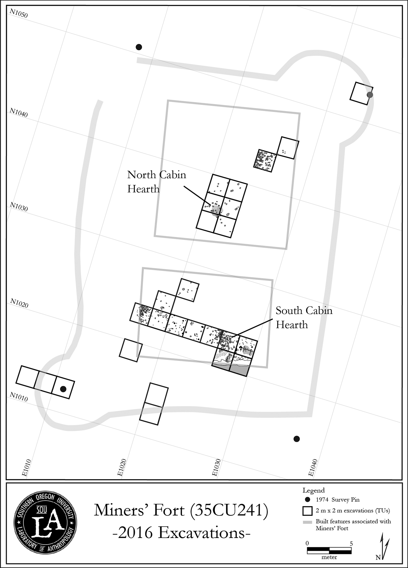
Figure 7. Plan view of the archaeological excavations at Miners’ Fort showing the locations of the fort's walls, bastions, and internal cabins as identified by the remote sensing.

Figure 8. Clay tobacco pipe recovered from the north cabin at Miners’ Fort (Southern Oregon University Laboratory of Anthropology).
Most artifacts were found within 25 cm below the ground in an organic-rich, dark brown/black, fine, clayey loam mottled with gray fine silt. This matrix contained little to no coarse content other than manuports of beach or river cobbles discontinuously distributed across the excavation. While no obvious sedimentary change or compaction marked the floor of the fort or the internal cabins, the artifact count clearly dropped off below that. Several features were observed that corresponded to those identified by the remote sensing. The outer walls and bastions of the fort were the most ephemeral. Relatively few iron nails were found in these areas, and the architecture was visible only as a slightly more mottled and slightly more clayey soil unit that could be followed and contoured with a trowel only with great difficulty. This is in concordance with the primary documents that indicate the walls of the fort were constructed expediently of stacked grass sod and were not significantly reinforced with logs or other material, as some later memoirs claimed. The west wall of the south cabin, identified by the magnetic gradient survey, was revealed to be a paving of river or beach cobbles brought to the site to serve as a wall footing or flooring in the otherwise muddy cabin. The south wall of the southern cabin was also identified and was a sharply linear boundary of burned and compacted red sediment in concordance with the line of the wall in the geophysical plans.
Excavations within the walls of two cabins revealed a rich signature of life within the fort. The feature in the middle of the southern side of the north cabin, assumed to represent the larger cabin, was a hearth composed of several rounded cobbles in a roughly 1 m diameter area. Inside the feature was a basin-shaped stain of heavily burned, compacted, and oxidized red and yellow sediment that continued up to 50 cm below the ground (Figure 9). The hearth in the southern cabin was composed of a large cobble pile adjacent to a burn pile of heavily oxidized iron artifacts. This hearth was built in the style of a camas oven, a lenticular platform of cobbles used as a subterranean or semisubterranean roasting oven, a feature of indigenous design found commonly in archaeological sites in western Oregon and elsewhere in the far West (Figure 10).

Figure 9. Hearth feature of rounded cobbles—some displaced by field plowing—and an internal sediment matrix of burned and reddish-yellow compacted earth located within the north cabin within Miners’ Fort (Southern Oregon University Laboratory of Anthropology).

Figure 10. Camas oven hearth feature of indigenous design—a lenticular pile of rounded cobbles used as a roasting platform or earth oven—uncovered within the south cabin at Miners’ Fort. Several indigenous women were inside the fort with their settler husbands during the siege, and they likely built and used this feature (Southern Oregon Laboratory of Anthropology).
The artifacts recovered in context through excavations at Miners’ Fort indicate something about the social experience of the inhabitants while under siege. The presence of clay tobacco pipes, alcohol bottles, medicine bottles, inkwells, lantern glass, and other domestic artifacts point to a desperate normality inside the fort that is belied by the dearth of faunal remains other than miniscule particles of calcined bone, the spread of fired musket balls found across the fort, and burned wagon and firearms parts found within the hearths, indicating duress from starvation, hostile fire, and scarcity of firewood. The urgency of their situation is also indicated by the large number of freshly molded musket balls and associated slag and sprues that were scattered across Miners’ Fort, which was occupied for one month, in number and density greater by several orders of magnitude than recovered from Fort Lane, which was occupied for three years (Tveskov and Cohen Reference Tveskov, Cohen, Ferris, Harrison and Wilcox2014; Tveskov and Rose Reference Tveskov and Rose2019). In contradiction to the written accounts, these lead munitions came not just in the form of small pellets but also larger round balls of a variety of calibers, indicating that several kinds of functional weapons besides shotguns were used. The fragments of transferware dishes and robust leaded glass vessels, as well as the large quantities and kinds of glass beads, suggest that even in desperate flight, the settlers prioritized saving some of the more symbolic trappings of culture and status.
Summary and Conclusion
At Miners’ Fort, Fort Lane, Camp Castaway, and the Hungry Hill and Big Bend battlefields, we would not have been able to orient ourselves as effectively as we did by using only traditional excavation. At Miners’ Fort, remote sensing identified surface features not visible to the naked eye and efficiently identified subsurface architectural and domestic features. Subsequent excavations leveraged these data to reveal details about the architecture of the fort's earthen walls and the configuration of two internal cabins and their constituent features. The hearths inside the cabins were identified based on the size and geometry of the magnetic anomalies, the amplitude of the detected signal, and the alignment of the positive and negative components of this signal with respect to the earth's magnetic field, suggesting that they were caused by a local increase in soil magnetic susceptibility values, likely due to thermal enhancement relative to the surrounding natural soils. What was not apparent from the geophysical survey was that one of these features was a hearth of indigenous rather than settler design. The identification of this hearth, which was probably built by one or more indigenous women who were in the fort with their settler husbands, challenges the public memory of Miners’ Fort as a bastion of settler colonialism (see Tveskov Reference Tveskov2017).
In our experience in archaeology in the Northwest, Midwest, and the Northeast of North America and with many projects coordinated with the PBS television show Time Team America, remote sensing techniques spark considerable interest and enthusiasm among nonarchaeologists, including, as Sunseri and Byram (Reference Sunseri and Byram2017) point out, our partners from descent communities. While any avenue to bring archaeology to a wider audience should be explored, it seems that the interest in remote sensing is often grounded on the novelty of the technology and the promise (not always the reality) of useful results at site interiography or conservation.
A range of remote sensing techniques and traditional excavation can provide insights based on previously unseen associations and contexts among artifacts, ecofacts, and features. When coupled with an inclusive public archaeology program, they can also engender enthusiasm, dialogue, and multivalent discussions and insights among diverse stakeholders. The public access to the Miners’ Fort excavations attracted people who shared stories of ancestors who had been there or nearby. Through the intersection of archaeology, remote sensing, and public engagement, we saw the diversity of people who used the fort, the desperation and power dynamics at play, and the creative ways that different residents used their backgrounds and knowledge to negotiate this colonial moment. Finally, we think and hope we were successful at leaving students and members of the local community—whether indigenous, descendants of settlers, or more recently arrived—feeling challenged, listened to, and positive about archaeology as an educational, reflexive, and community-building enterprise.
A conservation ethic in archaeology is essential, as is recognizing the sovereignty, cultural perspectives, and protocols of our indigenous partners. In addition, the use of an explicit research design followed by the professional publication and public dissemination of results are foundational values of our field. The points raised by Sunseri and Byram (Reference Sunseri and Byram2017) are well taken, particularly when and if remote sensing techniques are employed in a planned and probabilistic (opposed to an ad hoc) manner; when we can have some confidences that the geophysical results mean what they suggest they mean; and that these results, whether positive or negative, are reported in a way that truly realizes their curatorial potential as nondestructive agents of archaeological conservation.
Although descendant communities often see excavation as unnecessarily intrusive, sometimes it is seen as an opportunity to provide detail to their histories, particularly when long-term partnerships with archaeologists have been established (e.g., Gonzalez Reference Gonzalez2016; McBride et al. Reference McBride, Naumec, Bissonnette and Fellman2017; Murry Reference Murry2011; Silliman Reference Silliman, Ferris, Harrison and Wilcox2014; Tushingham and Brooks Reference Tushingham and Brooks2017; Tveskov Reference Tveskov2007, Reference Tveskov2015). There is also, we believe, added value and an obligation to bring archaeology to a diverse range of stakeholders, including residents, students, and the general public. We do not think it is wise to set ourselves up a priori as defenders, through a role as gatekeepers or priests of technological esoterica, of an assumed sacredness that may or may not actually be asserted by a community or that may be contested or fluid among or within a set of communities.
It may be true that one day the “repose and conformation of an archaeological object will be regarded much as the original provenience of excavated objects is regarded today” (Sunseri and Byram Reference Sunseri and Byram2017:1422). In the meantime, we still enjoy the benefit of engaging the materialities of the past on site, outside, and with a crowd. Some of the discussions over Miners’ Fort were difficult, such as when historical memories tied to notions of manifest destiny were challenged or when ideas about amateur or professional excavation were contested. Others were joyful, such as when students identified diagnostic artifacts or participants chatted amiably over a screen on a spot where their respective ancestors had fought a bloody battle. Overall, the public archaeology fostered, however modestly, a sense of trust between diverse stakeholders, including those who have felt alienated from the archaeological process, whether rural people, local settler descendants, or indigenous people. This alienation results, in part, from the gatekeeping and exclusivity of academic and regulatory archaeological praxis. A hands-off approach may be the best measure in some cases, and advocating this approach certainly signals considerable virtue. Nonetheless, our role as archaeologists is not solely to preserve but also to help provide access, engagement, and professional consultation to a richly textured and contested past to constituencies that extend beyond academia, as well as beyond tribal, state, or federal historic preservation officials.
Acknowledgments
The authors would like to thank Karen and Scott Knox, Ron Crook, Steve Donovan, Mark Kramer, Richard Watson, and the community of Gold Beach, Oregon, for their hospitality. We are grateful for the support of Chief Donald Ivy, Betty Hockema, Bridgett Borchman-Wheeler, and Kassandra Rippee from the Coquille Indian Tribe; Robert Kentta from the Confederated Tribes of Siletz; David Harrelson of the Confederated Tribes of Grand Ronde; and Joel Bravo, Loren Bommelyn, and Suntayae Steinruck from the Tolowa Dee-ni´. The Miners’ Fort project was supported in part by the Oregon Parks and Recreation Department, and we thank Nancy Nelson and Trevor Taylor. A terrific archaeological field school executed the project, and we are grateful for sharing those experiences with the students. We also appreciate the continued support of Dan DeNeui, Mark Shibley, and Joanne Preston at Southern Oregon University and Sigrid Arnott, Andrew Bastier, Amy Cohen, Ashley Cordes, Kyle Crebbin, Dan Edgerton, Lynn Gamble, Dennis Griffin, Katie Johnson, and Ben Truwe, who contributed to the project. Finally, the lead authors would like to thank David Maki and Geoffrey Jones, who transfixed us with their mystical gizmos and the phantasms that they conjured.
Data Availability Statement
The Miners’ Fort excavation was conducted under an archaeological permit (AP 2147) issued by the Oregon State Historic Preservation Office to the Southern Oregon University Laboratory of Anthropology (SOULA). All field notes and artifacts from the project are curated at the SOULA lab at Southern Oregon University in Ashland, Oregon, under curation number 2016.03.


