


The late prehistoric and early historic ancestral Wichita communities that inhabited Kansas and northern Oklahoma during the period from about AD 1425–1650, archaeologically known as the Great Bend aspect (Blakeslee and Hawley Reference Blakeslee, Hawley, Hoard and Banks2006; Wedel Reference Wedel1935, Reference Wedel1959:571–588), are associated with the construction of enigmatic earthworks commonly known as “council circles” (Wedel Reference Wedel1967). Only five of the larger settlement sites in the region possess remains of features conventionally regarded as council circles (Figure 1). Each of these sites is home to an earthwork that has a low mound at the center of a plaza or open area, surrounded by a circular or sub-rounded ditch or series of ditches measuring up to 60 m in diameter (Figure 2). Excavations of council circles have revealed habitations, cache pits, ritual offerings, and exotic goods within pits and beneath mounds, leading to an ongoing debate among specialists regarding their function. Council circles have been interpreted variously as astronomical calendars and ritual sites (Wedel Reference Wedel1967), the residences of chiefly elites or warrior societies (Vehik Reference Vehik2002a, Reference Vehik2002b), or as a regional variant of defensive fortifications found throughout much of the southern Great Plains (Baugh and Blaine Reference Baugh and Blaine2017; Drass et al. Reference Drass, Perkins, Vehik, Clark and Bamforth2018; Hollinger Reference Hollinger2005). Whatever their purpose, most scholars agree that, although these circular earthworks may have once been more common, twentieth-century agricultural land use in the southern Great Plains has likely destroyed most evidence of these features. After several years of archaeological reconnaissance and aerial survey, Waldo R. Wedel (Reference Wedel1967:54) concluded, “If additional circles were visible before agricultural operations broke up the surfaces of the many known sites . . . nothing in the patterns of crop growth or soil coloration has so far been recognized as indication of their presence.”

Figure 1. Map of the region showing location of key sites discussed in the text. (Color online)

Figure 2. Aerial views of earthworks described as “council circles” at (a) Paint Creek (14MP1), (b) Paul Thompson (14RC12), and (c) Sharps Creek (14MP301); (d) excavations of the circular “basin” at Tobias (14RC8) (Figure 2a–c from Wedel Reference Wedel1967; Figure 2d after Wedel Reference Wedel1959:Plate 24; reprinted with permission).
This article presents the results of a multi-sensor aerial remote-sensing survey using drone-acquired thermal, near-infrared (NIR), and visible light imagery at a large Great Bend aspect settlement, originally recorded as the Country Club Site (14CO3), near Arkansas City, Kansas (see Figure 1). Situated on a high bluff near the confluence of the lower Walnut and Arkansas Rivers, the site, first excavated by Wedel (Reference Wedel1959:351–356), derives its name from a golf course that is built on part of the site. The bluff once contained 10–15 mounds, most of which have been affected by looting and construction (Figure 3); however, several mounds remain extant and are resolvable in lidar and aerial imagery (Figure 4). The Country Club site is located within a cluster of 20 other Great Bend aspect sites located along an 8 km stretch of the Walnut River (Hoard Reference Hoard2012; Lees et al. Reference Lees, Hawley, Schoen and Hoard2012; see Figure 5). Wedel (Reference Wedel1959) argues that this site cluster collectively formed a single large community, and scholars have since suggested it as the best candidate for the location of a major settlement reportedly encountered by the Spanish conquistador Juan de Oñate in 1601, termed the “Great Settlement” or “Etzanoa” (e.g., Blakeslee Reference Blakeslee2018; Craddock Reference Craddock2013; Vehik Reference Vehik1986). Although there are unsettled questions regarding the veracity of historical accounts, as well as the contemporaneity of the numerous Great Bend aspect occupations in the lower Walnut River valley, evidence nonetheless suggests that the area was home to a significant, if spatially dispersed, ancestral Wichita community.
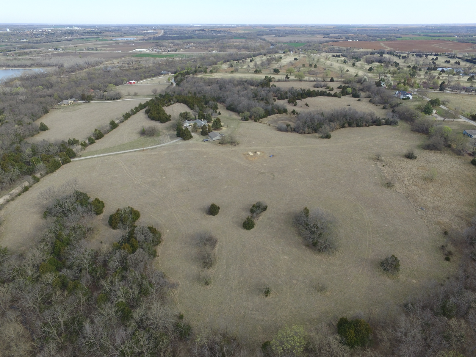
Figure 3. Aerial view of a portion of the Country Club site (14CO3) looking north, with the House property in the foreground and the golf course beyond (photograph by Jesse Casana). (Color online)

Figure 4. Map illustrating the area of our drone survey and the adjacent golf course that was originally recorded as the Country Club site (14CO3), as seen on aerial photography (left) and public lidar data (right). Lidar data reveal what are likely several extant archaeological mounds on the golf course grounds (aerial photography courtesy of United States Geological Survey's National Agriculture Imagery Program; Lidar data courtesy of the State of Kansas's Data Access and Support Center). (Color online)

Figure 5. Map illustrating Great Bend aspect sites recorded in the lower Walnut River. Twenty-two of these sites have now been combined into one large site (14CO3), officially renamed Etzanoa.
Our survey explores an 18 ha (44.5 acres) area of largely undisturbed native prairie, used today as a cattle ranch and located on a high bluff above the Walnut River just south of the golf course originally recorded as the Country Club site (14CO3). The survey sought to determine whether any archaeological features could be resolved in thermal or multispectral imagery, because recent research has demonstrated the potential of these technologies to reveal a wide range of architectural, ritual, or land use features (Casana et al. Reference Casana, Kantner, Wiewel and Cothren2014, Reference Casana, Wiewel, Cool, Hill, Fisher and Laugier2017). Ancient earthworks, for example, can be recognized in thermal and NIR imagery even if they have no visible topographic expression, because the remains of infilled ditches often retain water differentially than surrounding soil, producing distinct thermal properties and influencing vegetation growth (McLeester et al. Reference McLeester, Casana, Schurr, Hill and Wheeler2018). Our survey reveals the remains of what is most likely a circular earthwork, as well as numerous other features that may be infilled borrow pits and pithouses, both of which are commonly found at Great Bend aspect sites (Blakeslee and Hawley Reference Blakeslee, Hawley, Hoard and Banks2006). Our discovery suggests the presence of at least one large-scale communal facility at this important site; it further demonstrates the potential for large-scale, prospection-based thermal and NIR drone surveys to reveal previously unknown and otherwise invisible archaeological remains at sites in the Great Plains and beyond.
Background
Great Bend Aspect Settlement
Archaeological sites of ancestral Wichita communities, classified in the Great Bend aspect, are found in central Kansas and northern Oklahoma and are clustered in three areas: the Little River focus and the Lower Walnut focus originally described by Wedel (Reference Wedel1959, Reference Wedel1935), and the Marion focus described in the 1980s (Lees Reference Lees1988; Lees et al. Reference Lees, Reynolds, Martin, Adair and Bozarth1989). Within each of these areas, archaeologists previously recorded many village-sized sites marked by the presence of midden mounds and small depressions that are the remains of cache pits. Domestic architecture has been difficult to detect at most of these sites, because the houses were constructed in very shallow pits and the accompanying features such as arbors and drying racks were located at ground level. As a result, only a few shallow pithouses and suspected arbors have been excavated (Blakeslee and Hawley Reference Blakeslee, Hawley, Hoard and Banks2006). Most Great Bend aspect settlements are located along river valleys where there is easy access to rich farmland, and archaeological remains make clear that their residents grew crops of corn, beans, squash, and sunflowers while hunting bison in large quantities. In addition to the towns, stone quarries, numerous hunting camps, several petroglyph sites, and two unusual geoglyph-like earthworks dubbed “intaglios” have been documented elsewhere in the region (Blakeslee and Hawley Reference Blakeslee, Hawley, Hoard and Banks2006; Mallam Reference Mallam1985; Peck Reference Peck2003).
The largest Great Bend aspect settlements characteristically form clusters of sites spread over large areas, as documented by surveys in Rice, McPherson, and Marion Counties, Kansas, as well as in the lower Walnut River area. These sites originally contained numerous low midden mounds and storage pits; five also have earthworks commonly termed “council circles,” following the designation given to them by nineteenth-century relic hunters (Figure 1). The sites generally recognized as having council circles are three in Rice County that were excavated by Wedel from the 1930s to the 1970s—Tobias (14RC8), Paul Thompson (14RC12), and Kermit-Hayes 2 (14RC13)—and two sites in adjacent McPherson County: Paint Creek (14MP1) and Sharps Creek (14MP301). There is considerable morphological diversity among known council circles, but they all possess several key features—notably a central low mound, rarely more than a meter in height, covering a so-called patio area that is surrounded by structures that, in turn, are surrounded by a continuous ditch or a series of elongate ditches, forming an enclosure measuring 45–65 m. At the Tobias site, Wedel (Reference Wedel1959, Reference Wedel1967) trenched the patio area and excavated four sausage-shaped structures around it, each measuring approximately 3 m wide and 1 m deep, but of varied lengths (8–13 m). These “basins,” as Wedel terms them, include a range of features inside them indicative of occupation: well-preserved hearths, posts and postholes, storage pits below the floor, and concentrations of domestic artifacts including pottery, end scrapers, and other tools (Figure 2). Magnetic survey at Sharps Creek (14MP301) similarly reveals a complex series of subterranean basins and trenches (Somers et al. Reference Somers, Maki and Jones2012), possibly the result of rebuilding episodes throughout the site's history. Wedel (Reference Wedel1967) argued that council circles were divided into quadrants, an indication of what he believed to be their ritual function. At two sites, human remains were found scattered throughout these structures, but they do not appear to have resulted from formal burials: they have been interpreted either as secondary internments (Wedel Reference Wedel1967:62) or possibly as victims of a massacre (Baugh and Blaine Reference Baugh and Blaine2017). Surrounding the enclosure basins or structures are often large, bean-shaped topographic depressions, forming either continuous trenches or discontinuous pits, possibly used as extraction pits for daub.
Uncertainty remains regarding the function of council circles and indeed whether they constitute a distinct type of earthwork or simply are a regional variant of more commonly encountered enclosures. Based on their unusual configuration, the archaeological materials they contain, and their alignments, Wedel (Reference Wedel1967, Reference Wedel and Aveni1977) argues that council circles were primarily ritual centers and suggests they may have functioned as astronomical calendars. Conversely, excavations show that council circles often contain not only significant evidence of domestic occupation, including hearths, grinding stones, and lithics, but also a high percentage of elite and imported objects, leading Vehik (Reference Vehik2002a, Reference Vehik2002b) to argue that they are best interpreted as the residences of chiefly or priestly elites. Alternatively, some scholars have argued that council circles are defensive fortifications, similar to those found elsewhere in the Great Plains (Baugh Reference Baugh2007; Baugh and Blaine Reference Baugh and Blaine2017; Drass et al. Reference Drass, Perkins, Vehik, Clark and Bamforth2018; Hollinger Reference Hollinger2005). For example, several sites in Oklahoma and the Texas Panhandle associated with the roughly contemporary Wheeler phase (AD 1450–1725), including Duncan, Edwards I, and Bridwell, have large circular ditches that appear to have been fortifications surrounding villages, and it is possible that council circles served a similar function (Baugh and Blaine Reference Baugh and Blaine2017:122–124). Certainly, there is strong historical and archaeological evidence from more recent periods when larger Wichita communities were sometimes surrounded by defensive palisades, but there has been no sustained effort to determine whether council circles similarly contained a palisade wall inside the ditches.
Historical Accounts of Ancestral Wichita Communities
Our understanding of Great Bend aspect communities and the organization of their settlements is greatly enhanced through the documentary records of Spanish conquistadors and explorers, which, although deriving from a brutal colonial legacy, are nonetheless a key historical resource (Perkins et al. Reference Perkins, Drass and Vehik2016). The first probable European encounter with ancestral Wichita communities was during Francisco Vásquez de Coronado's expedition of 1541 (Flint and Flint Reference Flint and Flint2005). While he was in what is today New Mexico, Coronado was told of a region called “Quivira” where there was said to be large settlements along a great river and items made of what the Spaniards thought was gold (Wedel Reference Wedel, Wyckoff and Hofman1982). He eventually reached central Kansas and found large settlements, but they consisted of grass houses occupied by agriculturalists who had no gold to offer. The lure of the fabled place nonetheless led to further expeditions. In the mid-1590s, Antonio Gutierrez de Humaña and Francisco Leyba de Bonilla led an unauthorized expedition, first to New Mexico and then onto the Plains, but they were reportedly killed, probably in central Kansas. One survivor of the expedition, a native of Mexico called Jusepe, said that they had indeed found a large settlement (Simmons Reference Simmons1993), extending for many miles along a river, with houses built of grass roofs closely spaced together and surrounded by agricultural fields (Craddock Reference Craddock2013).
The best-known expedition occurred a few years later in 1601 under the leadership of Juan de Oñate, a controversial figure who is credited with founding the province of New Mexico, serving as its first governor from 1598 to 1610, but who is also remembered for his cruelty toward Indigenous communities. A transcription and retranslation of pertinent documents from the Oñate expedition by the Cibola Project at the University of California, Berkeley (Craddock Reference Craddock2013), provide the most comprehensive summary of accounts: these documents include the official account of the expedition, two maps, reports from five of Oñate's soldiers, and the interrogation of an American Indian prisoner captured at the Great Settlement. According to historical reports, Oñate set out in 1601 aiming to arrest the leaders of the earlier expedition, Humaña and Bonilla; to inspect the large reported settlement; and to determine whether Quivira was close to either the North Sea (Atlantic) or the Strait of Anian, the Spanish version of the Northwest Passage. His guide led him down what was likely the Canadian River, then north–northeast across what is now Oklahoma and probably to the Salt Fork of the Arkansas River (Hammond and Rey Reference Hammond and Rey1953; Vehik Reference Vehik1986). There, Oñate reports encountering a large camp of nomads he calls “Escanxaques,” who told him of other camps up and down the river and of a large settlement to the north. They led him for about two and a half days to the junction of two rivers, possibly the Walnut and Arkansas Rivers (Hammond and Rey Reference Hammond and Rey1953; Vehik Reference Vehik1986), where he reports finding a sprawling town that he called the “Great Settlement”: “We reached a town of more than 1,200 houses, all standing on the banks of another river of respectable size that at that point flowed into the large one. They were all round, made of wooden posts surrounded by poles and covered on the outside down to the ground with straw (Relación cierta y verdadera [fol. 154v/110v]; translation by Craddock Reference Craddock2013).
A subsequent interrogation of the prisoner captured during the campaign suggests that the name of the Great Settlement was “Etzanoa,” the location of which is indicated on a map produced during the interrogation (Craddock Reference Craddock2013). Official reports of the expedition called the inhabitants of the Great Settlement “Rayados,” referring to their prominent tattoos, which extended from their eyes to their ears. There has been ongoing discussion about the veracity of the various historical accounts that constitute the records of the Oñate expedition, as well as the identity of the tribes they encountered, their relationships to later Wichita communities, and how these groups might map onto the archaeological assemblages from the region (Perkins et al. Reference Perkins, Drass and Vehik2016).
Based on historical records, Blakeslee (Reference Blakeslee2018) argues that the Great Settlement may have contained as many as 2,000 houses and thus would have been one of the largest ancestral Wichita settlements and perhaps the largest seventeenth-century settlement north of Mexico. Yet, as with any historical record, it is difficult to disentangle the complex set of political concerns and other issues that may have influenced reports regarding the size, location, and character of communities encountered by the Oñate expedition. Understanding how these settlements are manifested in the extant archaeological record today is similarly problematic, but a long history of scholarship has nonetheless accepted the existence of the Great Settlement/Etzanoa and sought to locate it somewhere in the region.
Archaeological Evidence for the Great Settlement/Etzanoa
Although earlier scholars had suggested locations for the Great Settlement/Etzanoa as far south as Oklahoma and as far north as the area previously explored by Coronado, the most common view, based on the description of the route traveled by the Oñate expedition, is that the settlement was located at the confluence of the Walnut and Arkansas Rivers (Hammond and Rey Reference Hammond and Rey1953; Vehik Reference Vehik1986, Reference Vehik2002a; Wedel Reference Wedel1990). If true, archaeological remains of the settlement might therefore be found within the Walnut River focus sites of the Great Bend aspect. Wedel (Reference Wedel1959:346) was the first to suggest that the cluster of sites in the lower Walnut River near Arkansas City may have been a single large settlement; he noted, “The remains investigated by our party on the lower Walnut have been grouped under three site headings [14CO1, 14CO2, and 14CO3]. The high degree of uniformity manifested in the collections and in their manner of occurrence suggests that this grouping is an arbitrary one, and that the sites may actually have been merely local concentrations of population within one great rambling community.”
Wedel excavated in the lowlands at 14CO1 and 14CO2, where most features had been destroyed by agriculture, as well as on top of the eastern bluff, designated as the Country Club site (14CO3). He believed the Country Club site to be the most promising location for excavations, because it was situated at the highest point along the river bluffs and possessed at least 10–15 mounds; he suggested that it was “perhaps the central feature of the once-extensive settlement in the Arkansas City locality” (Wedel Reference Wedel1959:351) and possibly the ritual center of the larger community. Even though the presence of the golf course gave the site a modicum of protection from development, Wedel had a difficult time gaining access to it, and so, after a brief excavation of one mound, he shifted the focus of his work farther north to Rice and McPherson Counties.
Wedel's (Reference Wedel1959) findings of numerous Great Bend aspect settlements in the lower Walnut River led to ongoing speculation that it could be the remains of the Great Settlement/Etzanoa. Vehik (Reference Vehik1986) undertook an analysis of historical and archaeological evidence and argues that the lower Walnut River sites are the best candidate for Etzanoa. Hawley's (Reference Hawley2000) analysis of surface collections from sites in the area shows that they possess a rich array of imported exotic goods and occasional items of European manufacture, such as glass beads and iron tools, pointing to the probable historical significance of sites in the lower Walnut River cluster. An investigation conducted by the Kansas State Historical Society in advance of levee and highway construction in the 1990s recorded additional sites in the region, largely in the lowlands: 440 pit features at eight localities were excavated and recorded as separate sites, revealing the extent of Great Bend aspect settlement in the area (Hoard Reference Hoard2012; Lees et al. Reference Lees, Hawley, Schoen and Hoard2012). State site records ultimately included more than 20 Great Bend aspect sites situated along an 8 km area on both sides of the lower Walnut River (Figure 5). These sites could simply be interpreted as shifting, short-term occupations by small communities that over time produced a palimpsest of archaeological remains or perhaps as a single, large, dispersed community, as argued by Wedel (Reference Wedel1959) and Blakeslee (Reference Blakeslee2018). Although it would be difficult to establish the contemporaneity of the scattered Great Bend aspect sites in the lower Walnut River without extensive testing, the sheer number of sites, combined with the presence of several sizable mounds at the Country Club site (14CO3), suggests that the area was home to a significant population.
Unfortunately, today much of the lower Walnut River is under intensive development, with large parts of the archaeological landscape destroyed or obscured by modern buildings, roads, and agriculture (Figure 4). Moreover, the fact that the area is divided among dozens of private landowners makes any systematic investigation of the entire area difficult to undertake. Fortunately, the House property (ca. 18 ha), located at the southern end of the area originally designated as the Country Club site (14CO3), has been affected only by a house, shed, driveway, and a farm pond, with the remainder of the property either forested or used for pasture (Figure 3). Because of its potential for relatively good archaeological preservation, in 2016 Blakeslee initiated an excavation project at the House property (Blakeslee Reference Blakeslee2018; Malakoff Reference Malakoff2016). Excavations of the Great Bend aspect settlement conducted from 2015 to 2019 recovered two pieces of iron cartridge shot, one horseshoe nail, a scrap of iron, a metal alloy button, and a fragment of glass from what may be an ornate goblet, suggesting contact between the ancestral Wichita residents and the Spanish during the seventeenth century. These discoveries led to widespread media attention (e.g., Kelley Reference Kelley2018; Morris Reference Morris2017, Wenzl Reference Wenzl2017), the establishment of a local conservancy aimed at preserving the site (https://etzanoa.com/etzanoa/), official recognition of the site by the Kansas state legislature (State of Kansas 2017), and the development of a public archaeology program as a cooperative effort among the Etzanoa Conservancy, Arkansas City, Wichita State University, Cowley College, and the local school district (City of Arkansas City 2018). Alongside these efforts, the 22 Great Bend aspect sites initially recorded within an 8 km stretch of the lower Walnut River have now been collapsed in official state records into a single large site, retaining the designation 14CO3 but being officially renamed “Etzanoa.”
Methods
The survey we report herein was undertaken at the House family cattle ranch, an 18 ha area of largely undeveloped land located at the southern end of the site originally recorded as the Country Club site (14CO3), which Wedel (Reference Wedel1959) believed to be the ritual center of the larger Great Bend aspect community. Although much of the surrounding area has been severely affected by intensive agriculture, as well as industrial and residential development, the House ranch has historically been used only for cattle grazing and thus offers better possibilities for archaeological preservation than elsewhere in the region. To prospect for potential archaeological features, we undertook a drone-based aerial survey using thermal, near-infrared (NIR), and visible light imagery, using methods similar to those employed in our previous research (Casana et al. Reference Casana, Kantner, Wiewel and Cothren2014, Reference Casana, Wiewel, Cool, Hill, Fisher and Laugier2017; McLeester et al. Reference McLeester, Casana, Schurr, Hill and Wheeler2018).
Thermal imagery was collected using a FLIR Vue Pro-R, a drone-optimized radiometric thermal camera that captures 14-bit still images in the thermal infrared light spectrum (7.5–13.5 μm) at regular intervals. The FLIR Vue series is based on the Tau 2 core, a thermal sensor with a resolution of 640 × 512 pixels and an advertised thermal sensitivity of 0.05°. Unlike conventional thermal cameras that employ an automated contrast adjustment algorithm to output images, radiometric thermal cameras like the FLIR Vue Pro-R are intended to record absolute values representing a combination of thermal radiance and emissivity (with a ± 5% range). This higher-resolution radiometric imagery enables discrimination of subtle differences in thermal properties of the ground (Casana et al. Reference Casana, Wiewel, Cool, Hill, Fisher and Laugier2017) and facilitates a range of quantitative raster methods to enhance feature visibility or reveal otherwise invisible anomalies (Hill et al. Reference Hill, Laugier and Casana2020; McLeester et al. Reference McLeester, Casana, Schurr, Hill and Wheeler2018). Although the FLIR Vue Pro-R is intended to record absolute thermal measurements, temperature accuracy is affected by the emissivity of the surface being recorded (Madding Reference Madding1999; Vollmer and Möllmann Reference Vollmer and Möllmann2017:34) and the values the sensor collects are prone to significant drift during the course of individual surveys, an issue that requires some means of correction (McLeester et al. Reference McLeester, Casana, Schurr, Hill and Wheeler2018).
Near-infrared imagery was collected using a Parrot Sequoia multispectral sensor, a drone-optimized camera system that collects four discrete spectral bands in the green, red, red-edge, and NIR, alongside a low-resolution RGB image. The camera system includes an irradiance sensor that is mounted on top of the drone, enabling improved reflectance calibration based on the amount of sunlight at the time images are collected. The four discrete bands collected by the Sequoia or other similar sensors can then be processed in any number of ways, the most popular being the production of a normalized differential vegetation index (NDVI) using the red and NIR bands. High-spatial-resolution NDVI imagery can potentially reveal a range of subsurface archaeological features such as stone walls, pits, ditches, or earthworks, as long as those features affect the health of vegetation on the surface above and the imagery is collected at a time in the seasonal greening cycle when differences with the surrounding vegetation are pronounced.
All thermal and multispectral imagery was collected using the currently discontinued 3DR Solo quadcopter. While it has shorter flight time capabilities than many newer drones, the 3DR Solo offers much greater flexibility in the integration of advanced sensors. A range of third-party gimbals are available for the drone that enable an easy swap between different camera systems. This support for third-party sensors means that the 3DR Solo can provide real-time imagery, along with telemetry data, to a ground station that, during flight, can both monitor the sensor data and record location data, as geotags written directly to each image file, from the drone's onboard GPS. This latter feature, the inclusion of GPS geotag data, is important for improving thermal post-processing results.
Finally, visible light images were collected using a DJI Phantom 4 Pro, one of the most popular commercial drones on the market because of its reliability, small size, long flight times, and high-quality camera. The Phantom 4 Pro incorporates a 1-inch mechanical shutter, rather than relying on a rolling shutter sensor like many smaller and cheaper drones; the mechanical shutter provides less distortion for photogrammetric processing. Flight mission planning for both drones was done using Pix4D Capture, with 80% forward overlap and 70% sidelap between adjacent transects.
Because the goal of most archaeological aerial thermographic surveys is to image the thermal energy that is emitted from the ground, rather than that which is reflected off the surface, it is generally necessary to collect imagery at night. The optimal time of night depends on a range of local environmental conditions, including the absolute temperature flux on the day of the survey, the amount of cloud cover and wind, the amount of soil moisture, and the relative humidity (Casana et al. Reference Casana, Kantner, Wiewel and Cothren2014, Reference Casana, Wiewel, Cool, Hill, Fisher and Laugier2017). Thermal surveys using the 3DR Solo were undertaken at 11:45 p.m. on the first night of our survey and again at 10:00 p.m. on the following night. They were conducted at an altitude of 40 m and at slow speeds (~4 m per second), requiring three flights to cover the unforested areas of the ranch. Multispectral imaging using the Parrot Sequoia on the Solo was similarly undertaken at slow speeds and with similar mission planning but is best collected at peak sunlight around noon. Finally, we undertook an early morning flight with the Phantom 4 Pro, whose higher-resolution camera and longer flight times enabled the entire ranch to be surveyed in a single flight.
Before conducting the drone surveys, 10 ground control point (GCP) markers were placed throughout the survey area. To ensure GCP visibility in the thermal imagery, we used 2 × 2 foot markers made of un-anodized aluminum flashing. Because of their very low thermal emissivity, most metals appear as very low values in thermal images, regardless of their temperature. Marker locations were recorded using an Emlid Reach RS system, a low-cost RTK mapping device (Hill et al. Reference Hill, Limp, Casana, Laugier and Williamson2019), and these coordinate data were then used to facilitate image alignment and georeferencing during photogrammetry post-processing.
Imagery from each thermal and multispectral aerial survey was then processed using Agisoft Photoscan Pro (now called Metashape) to create high-resolution, accurately georeferenced orthoimagery, while visible light images collected with the Phantom 4 Pro were used to create a large, high-resolution base map of the area along with a digital surface model of the site. Once generated, thermal and multispectral orthoimagery were imported into ArcGIS for additional processing, enhancement, and analysis. The thermal imagery was filtered, using a low-pass filter, to remove thermal drift and was then adjusted to increase contrast in the main areas of the site. A digital surface model (DSM) was processed, using the Relief Visualization Toolbox (Kokalj et al. Reference Kokalj, Zakšek and Oštir2011) in ArcGIS to create several hillshade visualizations as well.
Results
Visible light imagery was collected over the entire 18 ha of the House ranch property, whereas thermal and multispectral surveys focused on the 13 ha that are unforested (Figure 6). Although many thermal anomalies are evident in the imagery, most can be easily attributed either to modern land use, such as the semicircular and linear mowing scars and tracks found throughout the grassy areas of the survey, or to natural geologic formations, as along the edge of a small limestone bluff in the center of the survey: all of these anomalies can be effectively eliminated as archaeological features by comparing them to high-resolution visible light imagery and topographic data collected on the same day (cf. Casana et al. Reference Casana, Wiewel, Cool, Hill, Fisher and Laugier2017). The most clearly visible archaeological feature that is resolvable in the thermal data is a large, semicircular, low-value or “cool” feature, likely the remains of circular earthwork (Figure 7). The feature measures approximately 50 m in diameter and is around 2 m thick. The low-value thermal signature of the feature is best interpreted as a result of a former ditch having been infilled with eroded soils and that now preferentially retains water. Because water and wetter soils have relatively high thermal inertia, they often appear as relatively low values in nighttime thermal imagery. The size, shape, and regularity of the feature strongly suggest that it is anthropogenic and not a natural geologic phenomenon; according to the current landowners, the property has never been used for anything other than animal pasture, effectively ruling out its explanation as a modern or recent historic construction. Moreover, the feature is situated near the highest point of the property, on a bluff overlooking the river valley, consistent with the positioning of other known late prehistoric and early historic circular earthworks of the southern Great Plains.

Figure 6. Left: Drone-acquired orthoimage of the House family property in the Country Club site (14CO3) showing major features discussed in the text. Right: Thermal image mosaic collected from 11:15 p.m.–12:15 a.m. (Color online)

Figure 7. (a) Thermal imagery revealing a circular feature and associated pits; (b) color orthoimage mosaic, (c) NDVI produced from multispectral camera; (d) photogrammetrically derived DSM.
The earthwork may have originally formed a complete circle, but only about two-thirds of it are visible, which could be a result of erosion because it sits on gently sloping terrain and the downslope portions, where the circular feature has an apparent break, may be buried under colluvium-associated grazing in the past century. It is also possible that the circle was never completed or that it was intended to form only a partial enclosure. Two bean-shaped features, likely also infilled pits or ditches measuring approximately 10 × 15 m, are also visible on the exterior of the circular feature. If the circular feature once had additional subterranean pits, as has been documented at some council circle sites in central Kansas (Wedel Reference Wedel1967), they may also have been buried by erosion.
Although the circle and adjacent pits are clearly recognizable in thermal data, the circle is not evident in visible light imagery acquired the same day (Figure 7b), whereas the pits are visible because of the differential vegetation growth in them. However, both the pits and detectable portion of the circle have significantly higher NDVI values than surrounding areas (Figure 7c), strengthening our interpretation of these features as water-retaining infilled pits or ditches, because both wetter and organic rich soils of archaeological pits often encourage healthier plant growth. Unfortunately, the Parrot Sequoia multispectral camera stopped recording images during one flight due to a cable malfunction, resulting in a hole over the circular feature in the NDVI imagery. Unlike previously recorded council circles, the circular feature and extraction pits recorded in our survey have little in the way of topographic expression, and the center of the feature is elevated only a small amount above the surrounding fields, as revealed in a high-resolution DSM generated from visible light imagery (Figure 7d). However, other recent studies of known mounds and enclosures in the Midwest show that modern agriculture and pasture activities can obscure or remove all topographic expression of such features, even while traces of their existence are extant below ground and in geophysical data (Henry et al. Reference Henry, Shields and Kidder2019; Riley and Tiffany Reference Riley and Tiffany2014): a similar process could have affected the feature we observe in our data.
Seeking to determine whether the circular feature might be visible in other forms of aerial imagery, we examined all publicly available aerial photographs and high-resolution satellite imagery for the area. The circular feature is faintly visible in National Agriculture Imagery Program (NAIP) aerial photographs from June 21, 2015, and July 24, 2017, but not visible in imagery from June 2012 or in WorldView 2 satellite imagery from February 2017 (Figure 8). The fact that the circle is occasionally visible in a time series of aerial and satellite images provides confirmation that it is indeed a subsurface feature, most likely an infilled ditch, which affects vegetation growth and thus is most apparent in the summer months during peak greening. The visibility of the feature is, like much in archaeological remote sensing, highly dependent on a range of variables including soil moisture, vegetation health, and the incidence angle of the sun, all of which come together in sometimes unpredictable ways to affect visibility (Wilson Reference Wilson2000).
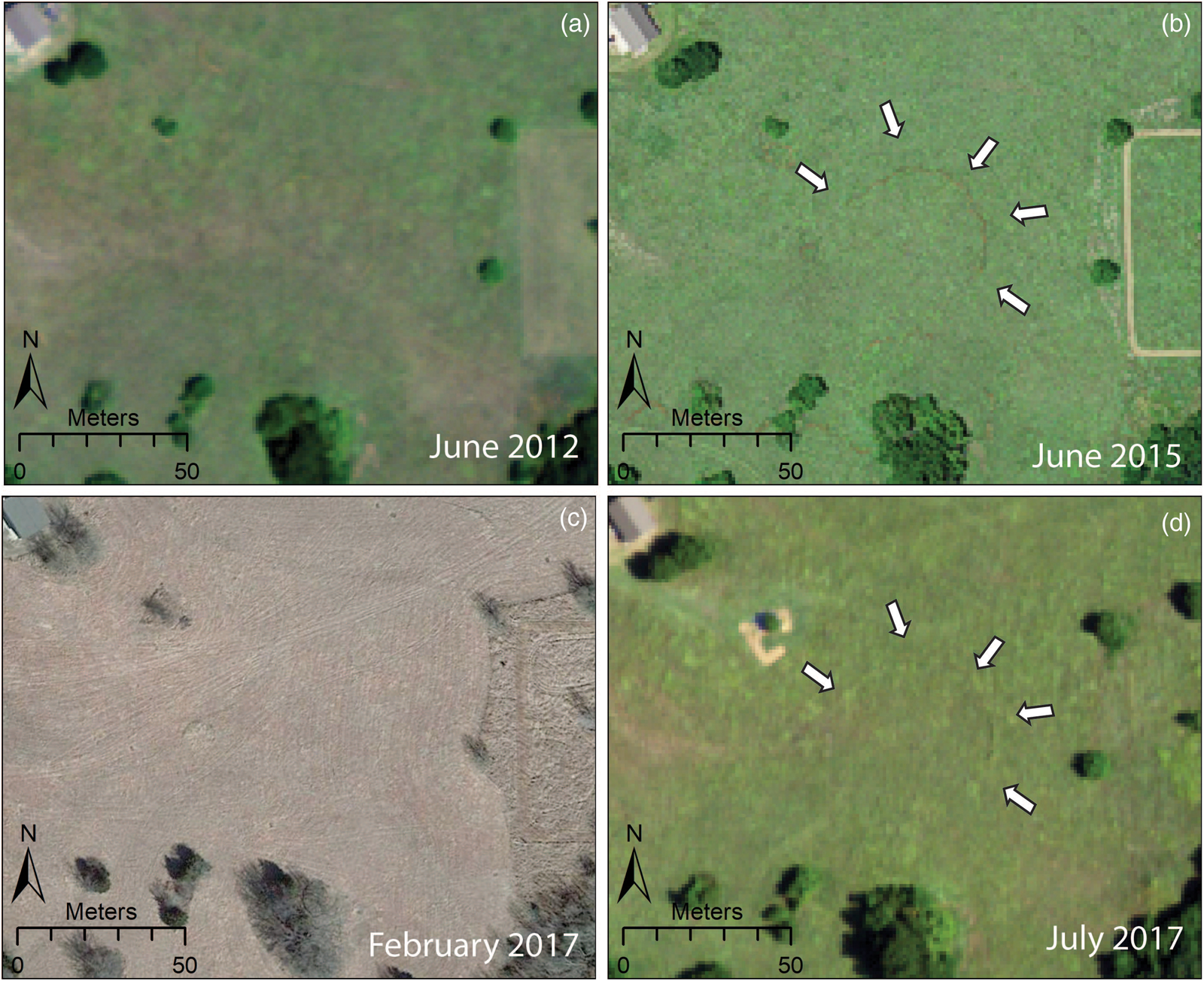
Figure 8. A time series of aerial and satellite images showing the circular feature faintly visible in June 2015 and July 2017, but not in June 2012 or February 2017. Images a, b, and d derived from the NAIP (courtesy of United States Geological Survey) and (c) from World View 2 satellite imagery (courtesy of Digital Globe © 2018). (Color online)
Careful analysis of thermal imagery in other surrounding parts of our survey area reveals other potentially significant archaeological features, notably several oval-shaped anomalies that are consistent with shallow infilled pits (Figure 9). These features measure 8–10 m in length and 4–6 m in width, and although they have little evident signature in the visible light imagery and no topographic expression, they all appear as low-value, cool anomalies in thermal imagery. Like the circular feature discussed earlier, the oval features also promote more robust vegetation growth, evident in significantly higher NDVI values within them. Thus, these features are best interpreted also as shallow infilled depressions. Many Great Bend aspect sites have evidence of large extraction pits, often in the vicinity of circular earthworks at the five sites where such features have been identified, presumably to mine the soil used in their construction, and the features we have documented could be something similar. They may, alternatively, be the remains of semi-subterranean or depressed house floors, which have been excavated at several Great Bend aspect sites (Blakeslee and Hawley Reference Blakeslee, Hawley, Hoard and Banks2006) and are well known at sites of the preceding Late Woodland/Mississippian period. Wedel (Reference Wedel1959:351) excavated one house floor at nearby 14CO2, which measured 3 m in diameter and had a hard-packed earthen floor, sunk 30–45 cm below the surface, with well-prepared walls and numerous daub fragments within it. Although the features at 14CO3 are larger than this and other known examples of contemporary pithouses, they conform well to the description of the houses at the Great Settlement preserved in Baltazar de Cogador's account:
The houses are set about 20 or 30 or 40 paces apart and they form something like districts, with 30 or 40 houses in each district, and between one district and another there are open spaces of 200 or 300 paces; and the houses are made of thin sticks set very close together in the ground that come together above like a tent, and at their base they are round, with a circumference of some 70 or 80 feet, with doors so low that you must get on your knees to enter [Valverde Interrogatories (fol. 169r); translation by Craddock Reference Craddock2013].
The circumference of the features visible in thermal imagery measure 19.5–25.0 m (65–82 feet) and are spread out at 15–30 m (20–40 paces) apart. Of course, our sample of these features is quite limited and determining whether they are the remains of houses would require excavation, but they nonetheless are promising locations for future investigations.

Figure 9. Thermal (top), NDVI (middle), and visible light (bottom) orthoimagery showing two oval features that are likely shallow infilled depressions, perhaps the remains of house floors. (Color online)
Discussion
Given the close material culture linkages of the Country Club site (14CO3) and other Walnut River focus sites with the Great Bend aspect assemblages of central Kansas, we might expect to find the best parallels for the circular earthwork we have documented in those areas. Certainly, the size of the earthwork, measuring approximately 50 m in diameter (Figure 10h), is broadly consistent with other so-called council circles of the Little River focus sites, which measure from 35 to 65 m (Wedel Reference Wedel1967), but vary in shape considerably (Figure 10a–e). For example, excavations at Tobias (14RC13; Wedel Reference Wedel1959, Reference Wedel1967) and magnetic survey at Sharps Creek (14MP301; Somers et al. Reference Somers, Maki and Jones2012) show that these earthworks can be quite complex, with multiple overlapping pits, basins, and ditches (Figure 10a–b). Other council circles at Kermit-Hayes (14RC13), Paul Thompson (14RC12), and Paint Creek (14MP1) have only been published in a manner that enables a relatively rough estimation of their size and configuration (Wedel Reference Wedel1967; Figure 10c–e), but these earthworks may also be more complex than is currently understood.

Figure 10. Comparison of the size and layout of earthworks discussed in the text: (a) Tobias (14RC8); (b) Sharps Creek (14MP301); (c) Kermit-Hayes (14RC13); (d) Paul Thompson (14RC12); (e) Paint Creek (14MP1); (f) Edwards I (34BK2); (g) Bridwell (41CB27); (h) Country Club/Etzanoa (14CO3).
As discussed earlier, the council circles of central Kansas have traditionally been interpreted as either ritual installations or elite residences. These features are uniquely associated with the largest Great Bend aspect village sites in the region, and excavations at Tobias (14RC8), Paul Thompson (14RC12), and Kermit-Hayes 2 (14RC13) all show evidence of ritual practice (Wedel Reference Wedel1967) and elite residential occupation in the form of exotic artifacts, including marine shell, imported chert, obsidian, turquoise, copper, and European metals and beads (Vehik Reference Vehik2002a). Furthermore, there is a long history of similar ceremonial earthwork enclosures from elsewhere in the Great Plains and the tallgrass prairie to the east, dating back to the Woodland period (e.g., Whittaker and Green Reference Whittaker and Green2010), and it is possible that the council circle sites continue a similar tradition.
Conversely, the closest morphological parallels for the feature we have found at the Country Club site (14CO3) may be with circular enclosures at the Wheeler phase (AD 1450–1725) sites of Bridwell (41CB27; Figure 10g) in the Texas Panhandle, as well as Edwards I (34BK2; Figure 10f), and Duncan (34WA2) in western Oklahoma. Earthworks at these sites measure 50 m in diameter, are circular, and, like the one we have documented at the Country Club site, have surface trench widths of approximately 2 m (Baugh and Blaine Reference Baugh and Blaine2017). Magnetic survey at Edwards I (Weymouth Reference Weymouth1981) suggests that the circular feature is relatively simple in plan, unlike at Tobias and Sharps Creek. Similarly, investigations at Bridwell (Parker Reference Parker1982) and Duncan (Baugh Reference Baugh1986) show the features are fairly simple, built of a single ditch about 2 m in diameter enclosing a low (<1 m) mounded area. Largely based on parallels with historical evidence from later periods, these sites and other similar earthworks in the region have been interpreted by Baugh and Blaine (Reference Baugh and Blaine2017) as defensive installations, probably ditches inside of which a palisaded wall would have been constructed. Many archaeological sites in the northern Great Plains show an increasing degree of fortification during the fifteentheighteenth centuries, leading to arguments that it was a phase marked by widespread intensification and sophistication of warfare (Clark and Bamforth Reference Clark and Bamforth2018). Although fortifications are much rarer in the southern Great Plains and historical accounts do not mention any (Vehik Reference Vehik, Clark and Bamforth2018), it is possible that the earthwork we documented at the Country Club site is an example of a defensive structure similar to those documented to the south and west. It is also plausible that preexisting circular earthworks built as ritual features or elite residences could have been repurposed as defensive installations in later periods. The resolution of the larger questions surrounding the purpose of the earthwork at the Country Club site and its relationship to other sites in the region would require additional investigations, but our data at least provide a provocative line of inquiry going forward.
Whatever the original function of the earthwork at 14CO3, its discovery substantially strengthens claims for the historical and archaeological significance of the cluster of Great Bend aspect sites located in the lower Walnut River area. The presence of a large, community-based structure and the numerous extant mounds recorded at the Country Club site recorded by Wedel (Reference Wedel1959), alongside the extensive cluster of settlements in the lower Walnut River covering more than 8 km, collectively point to a significant level of social complexity in the region. Although previous research has speculated that Great Bend aspect communities of the Little River focus may have had greater degrees of complexity than seen in areas to the south (Vehik Reference Vehik2002a), these new data show the existence of population centers that were similar in size or even larger and in which they were community-based construction efforts on a large scale. Ongoing excavations will certainly help provide additional evidence regarding social organization among the lower Walnut River focus settlements, particularly if findings from the circular feature and adjacent pits produce artifactual assemblages like those at similar large Great Bend aspect village sites.
Conclusions
This article presented results of a multi-sensor aerial remote-sensing-based investigation at a large ancestral Wichita village site in southeastern Kansas, the center of an extensive cluster of contemporary sites argued by some scholars (e.g., Blakeslee Reference Blakeslee2018; Vehik Reference Vehik1986; Wedel Reference Wedel1959) to have been the location of the “Great Settlement” or “Etzanoa” reportedly encountered by the army of Juan de Oñate in 1601 (Craddock Reference Craddock2013; Hammond and Rey Reference Hammond and Rey1953). Results reveal the presence of a 50 m diameter circular earthwork at the site, alongside a series of possible house basins and extraction pits in the vicinity. The earthwork could be interpreted as the remains of a council circle, similar to features known from five large ancestral Wichita sites in central Kansas; alternatively, it may be the remains of a defensive installation like those known from several contemporary sites to the south and west in Oklahoma and the Texas Panhandle. Although determining the purpose of the feature and its relationship to other earthworks in the region will require further investigations, the mere presence of a community-based construction on this scale is a testament to the historical and archaeological significance of the large cluster of Great Bend aspect sites located in the lower Walnut River valley.
More broadly, our discovery also serves as a powerful reminder that many archaeological features are likely preserved in the modern landscape that can only be recognized by employing appropriate technologies at large spatial scales. Research has already demonstrated the potential power of terrestrial geophysics to document North American earthworks and other features that have been presumed to been lost to modern land use (e.g., Burks and Cook Reference Burks and Cook2011). However, Kvamme (Reference Kvamme2003) argued more than 15 years ago that geophysical surveys could be employed even more broadly within a landscape framework, offering perspectives on the regional distribution of cultural activities beyond the site: it could thereby offer entirely novel approaches to understanding the human past and be a powerful tool for cultural resource managers. Although a handful of researchers, primarily in Europe, have employed geophysics in this manner, conducting exploratory, prospection-based geophysical surveys over tens or even hundreds of hectares (e.g., Donati et al. Reference Donati, Sarris, Papadopoulos, Kalaycı, Simon, Manataki, Moffat and Cuenca-García2017; Gaffney et al. Reference Gaffney, Gaffney, Neubauer, Baldwin, Chapman, Garwood, Moulden, Sparrow, Bates, Löcker, Hinterleitner, Trinks, Nau, Zitz, Floery, Verhoeven and Doneus2012; Křivánek Reference Křivánek2017), regional-scale, prospection-based geophysics remains rare in North America.
The suite of sensor technologies employed in this project offer a means to begin to achieve Kvamme's (Reference Kvamme2003) vision, because drone-based thermal and multispectral surveys not only can reveal a wide range of archaeological features that are otherwise invisible but can also be collected quickly, over large areas, at low cost. Our results from southeastern Kansas, as well as our previous work at sites in Illinois (McLeester et al. Reference McLeester, Casana, Schurr, Hill and Wheeler2018), New Mexico (Casana et al. Reference Casana, Kantner, Wiewel and Cothren2014), and New Hampshire (Casana et al. Reference Casana, Wiewel, Cool, Hill, Fisher and Laugier2017; Hill et al. Reference Hill, Laugier and Casana2020), show the potential power of thermal and multispectral drone-based imaging to explore archaeological landscapes. The technology offers a rapid, low-cost method to prospect for unknown archaeological features over large areas, with the potential to reveal architecture, earthworks, or other landscape features that are not easily resolvable using other methods. Thus, it is of immense value to future research in the Great Plains and beyond.
Acknowledgments
Research presented in this article was undertaken with funding through a grant from the National Endowment for the Humanities Office of Digital Humanities (HAA-256086-17), and we are grateful to this fine organization for its support of our work. Additional data processing support was provided by funding from the National Science Foundation's Archaeometry Program (ID#1822107). Equipment used in this article was purchased with the support of Dartmouth College and the Spatial Archaeometry Lab (SPARCL). Special thanks go to the House family, who generously provided access to the site and offered us exceptional hospitality during our work, as well as providing ongoing support to the investigations on their property. We also are grateful to Carolin Ferwerda for her assistance in preparing some of the imagery used in this article.
Data Availability Statement
All digital datasets collected and analyzed as part of this project are archived at Dartmouth College's Spatial Archaeometry Lab and, in coordination with Dartmouth Libraries, are available for review by qualified scholars.


