
NOMENCLATURE
- AIP
-
Airport Improvement Program
- COPPETEC
-
Project, Research and Technology Studies Coordination
- CTCEA
-
Brazilian Organization for Scientific and Technological Development of Airspace Control
- DECEA
-
Department of Airspace Control
- GMT
-
Greenwich Mean Time
- ICAO
-
International Civil Aviation Organization
- Infraero
-
Brazilian Airport Infrastructure
- LMA
-
Laboratory of Applied Meteorology
- NREL
-
National Renewable Energy Laboratory
- SBGR
-
Guarulhos International Airport
- SODAR
-
sonic detection and ranging
- UFRJ
-
Federal University of Rio de Janeiro
- WCA
-
wind change in altitude
- Wd
-
wind direction
- Wr
-
aligned wind
- Wt
-
total wind
- Φ
-
magnetic north correction
1.0 INTRODUCTION
Atmospheric conditions have positive or negative influences on aviation at any time and place(Reference Ahrens1). Meteorological products for aviation are chosen according to the user's knowledge of their applications, need and operational significance, ease of access and available technology. Aeronautical meteorology marks conditions through observations with continuous and integrated monitoring of the meteorological variables on the surface and at altitude, serving as raw material for the most appropriate operating procedures for safe, efficient and economical air traffic flow.
The first 500 m of the atmosphere starting from the surface is most critical, especially for the initial and final stages of flight operations, due to possible presence of turbulence, wind shear, sudden changes in wind direction and formation of fog(Reference Wallace and Hobbs2). These unsteady low-altitude atmospheric phenomena have negative impacts on safety of flight during the take-off, final approach and landing phases during which aircraft have relatively lower airspeed and compromised manoeuvrability due to extension of flaps, spoilers and exposed landing gear. However, the surface meteorological stations installed in airports are incapable of detecting most of the mentioned phenomena. Altitude meteorological stations would be able to detect such phenomena, but their temporal resolution of 12 hours (published at 0000 GMT and 1200 GMT) makes this capacity incompatible with the frequency and the time of occurrence of the reported phenomena.
The staff of the Laboratory of Applied Meteorology at the Federal University of Rio de Janeiro (LMA–UFRJ) has been conducting studies and experiments with two SODAR installations at Guarulhos International Airport (SBGR) in São Paulo, Brazil since 2011. This equipment is a low-cost, easily installed acoustic wind profiler (Fig. 1) that uses the reflection of acoustic pulses in the atmospheric inhomogeneities to estimate the wind direction and speed in three dimensions at 15-minute intervals(3). These activities have been allowing the development of methods for detection and prediction of the phenomena in question, with a potential of sequencing arrival and departures optimally as well as an increasing flight safety.

Figure 1. SODAR (sonic detection and ranging) equipment.
A monitoring and short-term forecasting (“nowcasting”) study of local weather was developed at Frankfurt International Airport in Germany using SODAR and other instruments(Reference Gerz, Holzäpfel, Gerling, Scharnweber, Frech, Kober, Dengler and Rahm4). The analysis showed a fairly stable system and indicated that the time of separation between aircraft could be reduced by about 75% when compared to the stipulated time by the International Civil Aviation Organization (ICAO)(5). The National Renewable Energy Laboratory (NREL)(6) compared wind direction and speed data for 120 days coming from a 70 m meteorological tower with measurements made by a SODAR instrument in Hebei, China. The data measured by SODAR showed excellent agreement with the meteorological tower data, with correlation coefficients equal to or greater than 0.96.
Chan examined the application and the performance of two mini-SODARs at the Hong Kong International Airport in China(Reference Chan7). The available data measurements in various heights show that mini-SODARs provide generally reliable information for aviation. They provide useful indications of wind shear at low levels, mechanical turbulence associated with markedly rough terrain, and downbursts related to thunderstorms. Through these case studies, it was found that mini-SODARs are very useful in monitoring wind direction change at low levels, since these events may compromise aircraft performance and safety.
The goal of this study is the qualification and quantification of the existing gains in the use of SODAR wind profiler information at SBGR to serve as the scope for establishing a conceptual model for changing in runway-in-use procedure, aiming to enhance air traffic safety and save aircraft fuel, allowing for planning runway-in-use changes driven by shifts in wind direction in order to minimise delays in landing and take-off procedures in these cases.
2.0 DATA AND METHODOLOGY
According to the Airport Improvement Program (AIP), SBGR has two parallel runways which are identified as 09R/27L and 09L/27R (Fig. 2). The lengths of Runway 09R/27L and Runway 09L/27R are 3,000 m (9,842 ft) and 3,700 m (12,139 ft), respectively(8). The runways cannot be used simultaneously since the lateral spacing between their centrelines is less than the minimum safe wake turbulence separation of 760 m (2,500 ft).

Figure 2. Schematic illustration of the runways from Guarulhos International Airport.
In situations with a low volume of air traffic, runway 09L/27R is used because this runway is longer and is closer to the airport apron. At times of heavy air traffic volume, runway 09L/27R is used for take-off and runway 09R/27L is used for landing, because the latter runway has high-speed exits and its threshold begins 500 m before the threshold of the runway 09L/27R, preventing the turbulence wake of landing aircraft from interfering with aircraft operating on runway 09L/27R. Runway 09 is aligned to the prevailing east wind, so it is considered the standard airport runway. Therefore, in the presence of west winds, the direction of landings and take-offs must be changed to the Runway 27 as explained below.
The methodology is based on an evaluation of data from SBGR, where there are two SODAR installations next to its runways. Therefore, the methods consist of collecting data from the Department of Airspace Control (DECEA) and on the Brazilian Airport Infrastructure Company (Infraero) about reports of changes in runway-in-use at SBGR, along with SODAR data at the airport. This study analyses change in runway-in-use cases with SODAR data from September 2011 to December 2013 (234 cases) following the conceptual model described below.
-
a) Firstly, cases where Runway 09 was changed to Runway 27 at the airport between September 2011 and December 2013 (available total time) are identified via movement data in SBGR. Analyses are based on dates and times (GMT) when the runway-in-use changes took place.
-
b) From the cases identified in item a, those cases in which wind actually changed at the surface are selected, that is, when there really was a need for runway change, with or without change in runway-in-use from air traffic control tower. Wind changes at altitude occur earlier than on the surface since the increased viscous friction near the ground delays the propagation of these changes in the wind field. Thus, only those that SODAR detected in relative advance of wind alteration at 300 m above the runway surface are considered. Moreover, the main objective of this study is focused on the gain that the instrument can provide, so it is selected for only the cases which it is observed. This comprises about 92% of the total.
-
c) Considering the wind profile change described in item b, these wind direction change patterns at the surface are identified via SODAR data. In Fig. 3, as an example, it is shown the wind vector measured by SODAR on 5 September 2011 in several vertical levels. It is noted that around 1100 GMT, the wind modified its direction on the surface from NE to NW, but at 300 m it had already changed by around 1000 GMT as highlighted in the black box.
-
d) Then, the resultant speed components aligned with the runway direction on the aircraft are calculated. This is made with wind direction and speed data on surface (minute by minute), considering operations on the Runway 09, in accordance with Equation (1):
(1)where Wr is the wind component aligned with the runway (the wind component in the direction of landing or take-off) in knots, Wt is the total wind in knots, Wd is the wind direction in degrees and φ is the magnetic north correction. Runways 09 and 27 are oriented to the magnetic north, that is, with a difference of around 20° from true north. Since the runways are oriented east to west, there is a slight inclination, as seen in Fig. 2. This explains the reason for the difference between the wind direction Wd and the angle of φ = 70° in the cosine of Equation (1). Thus, winds direction between 340° and 160°, passing by 0° (360°), mean normal operation on Runway 09, while wind direction between 160° and 340° indicates the need to use Runway 27. $$\begin{equation}{\rm Wr} = {\rm Wt}.{\rm{cos}}\left( {{\rm Wd} - \varphi } \right),\end{equation}$$
The Department of Airspace Control (DECEA)(9), which regulates the choice of runway, provides a selection of the most advantageous runway to air traffic control when the total wind Wt is less than 6 Kn. In this work, the definition of calm period relates to an aligned wind speed Wr that does not cause any inconvenience to air traffic (<1-6 Kn).
-
e) From the aligned wind Wr, wind intensity values from 0-6 Kn are filtered to check the calm period in each value selected with the aim of future comparisons in order to identify which one is the best to adopt.
-
f) Finally, the start time of the calm period via minute-by-minute surface data is identified. As the main goal is to identify the time between the calm period (with wind change in altitude in order to indicate future need of change in runway-in-use) and the time when the wind finally changes its direction on the surface, these conditions are evaluated with the aim of quantifying this period.


Figure 3. Example of wind vector measured by SODAR in SBGR on 5 September 2011.
Figure 4 shows a schematic diagram representing briefly the applied methodology in this study. Once SODAR detects the wind direction change at altitude, it must be observed when the air is calm at the surface. Thereafter, it becomes possible to arrange for a runway change before the wind direction change at the surface, so the aircraft flow doesn't suffer significant disruption.

Figure 4. Schematic flowchart representing the methodology of this research.
3.0 RESULTS AND DISCUSSION
In Table 1, as an initial demonstrative example, we present the values for the aligned wind Wr module up to 4 Kn, that is, the analysis considering possible change in runway-in-use in SBGR with Wr module less than 4 Kn and wind at 300 m with indicative of changing its direction between September and November 2011. The first two columns indicate the date and the time, respectively, when there was a change in runway-in-use ordered by the air traffic controller. Then, we show the outset of the calm periods around the change in runway-in-use time, or the period during which the aircraft from SBGR remained under aligned wind Wr less than 4 Kn.
Table 1 Analysis for the ligned wind Wr module up to 4 knots

Soon after the start times of calm periods in Table 1, there are the times when the wind began to change its direction at 300 m to indicate future change in runway-in-use (that is, outside the range of 340° to 160°) and the times when it changed on the surface, that is, the moment when it went from headwind to tailwind on the Runway 09 (even below the maximum value of calm period). This is verified more intuitively knowing that positive values of Equation (1) indicate a headwind (Runway 09, winds between 340° and 160°), while negative values indicate a tailwind and the need to switch to Runway 27 (winds between 160° and 340°) as in the wind rose shown in Fig. 5.

Figure 5. Wind rose for viewing the effect of winds between 340° and 160° indicating operation on Runway 09, while winds between 160° and 340° indicate operation on Runway 27 (see Fig. 2).
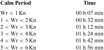
In this way, it is possible to make a calculation of the available total time to change in runway-in-use by programmed way (last column in Table 1), meeting economy and safety criteria, considering that for runway modification, it is necessary that the calm period on surface coincide with wind direction alteration at 300 m. Between September 2011 and December 2013, 234 cases of change in runway-in-use were analysed, as described previously. Table 2 summarises the available average time in each calm period (according to Wr values) when a change in runway-in-use could be carried out in order to contribute to greater efficiency in air traffic flow.
Table 2 Mean time available for changing in runway-in-use related to calm periods of aligned wind Wr

In all cases evaluated, there were significant calm periods on the surface as well as the anticipated modification of the direction of the wind at altitude, portending a later change at the surface. Checking the intersection of both scenarios, it was observed that there is adequate time for the air traffic controller to perform the change in runway-in-use, minimising the impact on aircraft flow. This period has an average duration of 1 hour and 24 minutes considering a calm period with Wr less than 4 Kn, and 1 hour and 42 minutes with a calm period with Wr less than 5 Kn.
It is important to note that the available periods to change in runway-in-use vary by method of evaluating the calm period. For example, considering calm period with Wr less than 3 Kn, there is a period for changing in runway-in-use about 1 hour and 12 minutes while for calm period with Wr less than 6 Kn, this time settles around 1 hour and 56 minutes.
Figure 6 shows the statistics associated with the changes in runway-in-use at Guarulhos International Airport taking into account wind and time (chronological) conditions reasonable for the air traffic. From 234 cases with changes in runway-in-use, 196 (84%) showed an indication more than 20 minutes in advance of wind direction change by SODAR at higher levels (about 300 m) before it changed on the surface, regardless of the calm period. This information is already very valuable for operational organisation purposes of landings and take-offs at an airport, since the indication that the surface wind will change in the future is essential for the proper precautions.

Figure 6. Percentage of cases in which there was a time of 20 minutes or more to perform the change in runway-in-use for safety reasons within 234 analysed occurrences. We consider cases where SODAR detected wind change in altitude (WCA), regardless of the calm period on surface, in addition to the occurrences where such changes were accompanied by calm periods with Wr less than 1, 2, 3, 4, 5 and 6 Kn, and calm period for Wt less than 6 Kn.
If we evaluate the cases in which this wind direction change anticipation was followed by a calm period on the surface, it is observed that in 41% of cases there was enough time (more than 20 minutes) for air traffic redirection under calm conditions with Wr less than 4 Kn and 58% for 5 Kn. Obviously, the higher the wind speed considered as a calm period, the more time the air traffic controller will have to perform the change in runway-in-use. Therefore, it confirms that the preliminary analysis of information provided by SODAR can help predict these changes, enabling a flow redirection and bringing economic and security advantages.
4.0 CONCLUSIONS
The creation and description of a conceptual model for changing in runway-in-use procedure in Guarulhos International Airport recognises that air traffic control centres depend dramatically on knowledge of weather conditions for their operations.
In the event of wind direction change, the runway for landings and take-offs must be changed so that aircraft always land or take off in the opposite direction to the wind at the surface and in the first metres of height above the airport. It was observed that there is enough time for the air traffic controller to plan and perform the change in runway-in-use while minimising the impact on the aircraft flow with the support of SODAR, and this period has an average duration of 1 hour and 24 minutes in a calm period where Wr is less than 4 Kn. In addition, it was found that in 58% of cases there was time (more than 20 minutes) for air traffic redirection under conditions of calm period on surface with Wr below 5 Kn, preceded by wind change in altitude detected by SODAR.
With this in mind, and knowing that the wind direction change associated with breezes and frontal systems primarily first occurs a few hundred metres above the surface mainly due to friction, the preliminary analysis of information provided by SODAR can help predict these changes, enabling a redirection of traffic flow and bringing advantages in economic and security terms, as shown. Currently, the LMA-UFRJ is developing predictive models based on artificial neural networks to perform nowcasting up to an hour at intervals of 15 minutes of the wind direction and speed at SBGR.
ACKNOWLEDGEMENTS
The authors thank the Project, Research and Technology Studies Coordination (COPPETEC) and the Brazilian Organization for Scientific and Technological Development of Airspace Control (CTCEA) for financial and scientific assistance, and the Department of Airspace Control (DECEA) and the Brazilian Airport Infrastructure Company (Infraero) for making data available.