


In a recent article, González-Tennant and González-Tennant (Reference González-Tennant and González-Tennant2016) consider the role of virtual reconstruction (VR) in archaeology through a series of case studies in Florida. Although the article is more broadly intended to alert archaeological audiences to advances in VR in archaeology, it also considers the role VR can play in re-creating the past. The article's authors suggest that through the current emphasis on grand sites, VR specialists (like heritage practitioners more generally) unconsciously participate in what Smith (Reference Smith2006:11) has identified as an “authorized heritage discourse” in which the monumental is celebrated at the expense of the ephemeral, creating the delusory effect of ignoring or suppressing a more common heritage, especially of marginalized or small communities.
This predicament, which Gonzáalez-Tennant and Gonzáalez-Tennant lament (and seek to rectify), is likely a consequence of the relationship between grand masterpiece heritage sites and opportunities for long-term sustained digital projects. Until recently, the cost and expertise required to create high-quality digital reconstructions demanded multi-year projects, the inclusion of digital specialists on research teams, and large budgets to sustain development. Consequently, it is hardly surprising that the subject of such effort would typically be grand and celebrated heritage sites (see, for example, the exemplary work presented by Der Manuelian Reference Der Manuelian2013; Gill Reference Gill2009; Lercari Reference Lercari2017; Wendrich et al. Reference Wendrich, Simpson and Elgewely2014).
The issues of time, budgets, and the need for dedicated specialists in developing VR is, perhaps, changing. With recent advances in open-source and other cost-effective tools and the rapid and unrestrained growth in web-based tutorials, the possibility of a new democratizing era in VR may now be upon us. Here, to illustrate the potential of VR as an accessible tool for reclaiming more common heritage sites, we present two case studies: the former tourist town of Sulphur Springs, Indian Territory and an ephemeral camp that formed around Mud Springs Telegraph Station in what is now western Nebraska during an engagement in the Great Plains Indian Wars. These two studies are emblematic of the circumstances surrounding much of the historical heritage of the Great Plains, where the lack of substantial, tangible heritage has limited the public's ability to engage with important sites, a condition we refer to as lost heritage.
In both cases, the reconstruction was not the central focus of research but a post-fieldwork exercise to explore the utility of VR, especially as it relates to more common heritage projects. As such, results attest to the accessibility and affordability of digital technologies that allow nonspecialists to use online tutorials to incorporate archaeological survey, historic maps, and other archival information into digital projects designed to share archaeological results with the public and explore possible new research avenues. The workflows were devised as part of a student-run project, and their subsequent development has continued with the goal of enabling nonexperts to produce similar results. Because the techniques described are accessible regardless of budget, expertise, or education, we hope our experience helps spur similar digital projects focused on lost heritage. To support this goal, we have provided links to supplemental online tutorials with step-by-step instructions outlining the more cost-effective workflow developed through our efforts (Douglass et al. Reference Douglass, Day and Brunette2018).
Beyond demonstrating the accessibility of our approach to nonspecialists seeking similar ends, this article also considers the utility of these reconstructions to aid in archaeological interpretation. Through our experiences, we seek to provide insight on how the rich graphic visuals of VR can be brought to bear on archaeological investigation. VR not only is a powerful tool to enhance archaeological presentation but also provides unique opportunities to augment and transform archaeological interpretation, expanding archaeological research in unforeseen directions (Sanders Reference Sanders2014).
VIRTUAL RECONSTRUCTION AND A COMMON LOST HERITAGE
Archaeological sites that have survived and been celebrated often reflect preservation choices, power dynamics, and accepted narratives for both prehistoric and historic cultural resources. Thus, what remains intact and protected today often consists of exemplary versions of period architecture, those locations associated with celebrated figures, or in many cases, locations that were either particularly robust or, because of their extended period of service, survived dereliction and obsolescence and eventually were deemed important. We can see this effect in the masterpiece approach used by UNESCO when considering world heritage designation (UNESCO 2017), with similar traditions guiding the practice of local and regional historic preservation organizations. Thus, the efforts to protect and celebrate the history of places like the Acropolis, Cahokia, and Monticello, mean that such sites are disproportionately represented in discussions of heritage.
While masterpiece sites are unquestionably important, there is a much larger part of our human legacy for which little to no tangible record remains for future generations to appreciate. This is the vast, often underappreciated, and often unmarked record that, because it lacks visibility, is inaccessible as a form of heritage. It is within this realm that the bulk of cultural resource management archaeology exists. Because of the circumstance surrounding their preservation, these sites are part of a lost heritage, and their removal from public view and community consciousness precludes the continued role of past places within the maintenance of contemporary social practice.
As described by González-Tennant and González-Tennant (Reference González-Tennant and González-Tennant2016), the history of minority communities is often not readily accessible through well-preserved heritage sites and displays, meaning this history is largely inaccessible as part of an active heritage display. This predicament is faced by the more representative record of our common heritage in general. Archaeology and historic preservation play important roles in how we understand the past, and the celebration of one form of heritage at the expense of another can silence part of that shared history. Furthermore, access to heritage also plays a role in how we see ourselves. In a recent volume entitled Legacies of Space and Intangible Heritage, Armstrong-Fumero and Gutierrez (Reference Armstrong-Fumero and Gutierrez2017) present a series of North and South American case studies, seeking to address the intersection between heritage management and contemporary cultural reproduction and maintenance. A key theme in the book is the important role access to historic places plays as an essential element in the process of maintaining the identity and customs that form a population's intangible heritage and how physical degradation, histories of migration and displacement, and negotiation with state-run heritage agencies affect different communities’ efforts to maintain their connection to place. The authors conclude that studies such as those presented demonstrate how “the growing importance granted to intangible heritage challenges archaeologists and other heritage workers with finding new ways of incorporating the cultural legacies that link societies to place into the work of research and stewardship” (Armstrong-Fumero and Gutierrez Reference Armstrong-Fumero and Gutierrez2017:12–13).
Contemporary populations in the Great Plains of North America face similar dilemmas of access and loss regarding the role of historic and prehistoric places in the maintenance and reproduction of intangible heritage. Though there are many locations that were central to forming the identities of both Native and European American Great Plains communities, more often than not, little remains of accessible tangible heritage. Furthermore, many of these heritage places are on lands with limited or restricted public access because of management agencies’ regulations or private property rights. Thus, with the exception of any historical markers, images in books, or perhaps local museum displays, many places that played a central role in the creation of Plains identity maintain scant evidence that could provide the public with a tangible connection and an understanding of the events that transpired there. These places are, in essence, part of a Great Plains cultural legacy but are not part of the cultural-appreciation process through which heritage plays a role in the re-creation of contemporary identity.
BACKGROUND TO THE STUDY
In our two case studies from the Great Plains, the issue of lost heritage rings true. Both are important for understanding the historic era. The town of Sulphur Springs, Indian Territory, was investigated through a compliance project between the University of Nebraska and the National Park Service (Douglass et al. Reference Douglass, Nycz and Brunette2016), whereas the historic site of Mud Springs Station was investigated through a collaboration between the University of Nebraska, the Nebraska State Historical Society, and the Midwest Archeological Center (Bleed et al. Reference Bleed, DeVore, Scott, Renner and Young2017). The goals of the projects were either to document remains for management or as part of ongoing research. In both cases, the findings were important, but public access to the information was limited because there was little extant physical presence with which to engage.
At Sulphur Springs, interactions with the local community indicated a clear desire for public access to the results of our work. Being aware of recent advances in digital reconstruction (see González-Tennant and González-Tennant Reference González-Tennant and González-Tennant2016; Sanders Reference Sanders2014, Reference Sanders2015 for summary of VR applications in archaeology), we decided to explore this option to communicate our findings. Using digital reconstruction was the obvious choice; however, we faced a number of predicaments. The project had a meager budget, and our crew lacked experience in developing digital reconstructions. Furthermore, access to specialist assistance proved difficult. We realized that any progress in developing a reconstruction would come from our own efforts. This meant we would need to rely on tools that were accessible and easy to use and could produce satisfactory results without substantial cost. We were aware of affordable and accessible software suited for this type of work and of online tutorials describing how to effectively use them. We also had a detailed GIS developed for our compliance work that was based on historic maps and archival data. With this knowledge and the GIS, we decided to pilot a project in student-based modeling to see how easily heritage reconstructions could be developed. The result is two projects and workflows that demonstrate the broad application of these techniques for related common-heritage projects.
Our goal is to share the process from archaeological and archival work through the construction of three-dimensional environments. Our experience was by no means straight forward; rather, we learned as we went and modified our approach several times. The workflow was devised by the authors and executed with graduate and undergraduate assistance. Moving from one step to the next, we relied on online video tutorials and other free online materials to solve problems and learn about opportunities. Through this process, our student-based project quickly moved from creating a simple reconstruction with open source CAD software to importing these models to Google Earth to mounting reconstructions over freely available lidar within ESRI ArcScene to ultimately working within an open-source video game development environment known as the Unity game engine.
SULPHUR SPRINGS, INDIAN TERRITORY
Sulphur Springs, Indian Territory, was a frontier community in what is now the Platt Historic District within the Chickasaw National Recreation Area in south central Oklahoma. At the time of its development, Sulphur Springs was part of the Chickasaw Nation. As such, only Chickasaw citizens could hold title to land. Sulphur Springs attracted primarily white settlers who only owned the improvements they constructed on lands leased from the Chickasaw. The emerging town was centered on a number of mineral springs and was conceived as a resort community that would capitalize on the early twentieth-century trend of the middle class “vacationing as a requirement for its physical, emotional, and spiritual well-being” (Aron Reference Aron1999:5).
Though the town had humble beginnings, investors in the community subscribed to a “If you build it, they will come” philosophy, and the town developed quickly during its first twenty years, having a main street, regular stage service from the railhead in nearby Davis, hotels, boarding houses, general stores, a dance pavilion, restaurants featuring singing waiters, and other amenities. While the town of Sulphur Springs rose from the prairie, the dream of a thriving resort never quite materialized. Instead, the town was, as one observer put it, “a little village of wooden shacks, with a few straggling board hotels sprawling over the hillsides” (McChristian Reference McChristian2003:38).
Circumstances began to change in 1902, when a few enterprising individuals conceived a plan. Though ostensibly sent to Washington, DC, to plead with representatives for a post office, Colonel R.A. Sneed, the owner of the town's largest hotel and a principal investor, returned with the announcement that the Chickasaw would sell 640 acres to the federal government to create a reservation. The land was purchased from the Chickasaw as a reservation designated to protect the springs from complete privatization (Boeger Reference Boeger1987). This agreement by the Chickasaw fit perfectly into the plans of the Sulphur Springs investors, who hoped to develop a resort similar to Hot Springs, Arkansas, which consisted of privately owned bathhouses located on federal land. Sulphur Springs, then, was the second natural springs resort in the West that the federal government invested in (McChristian Reference McChristian2003).
In making way for the park, the townsite moved several times, and ultimately all buildings were abandoned, destroyed, or relocated prior to 1906, when the former townsite was formally designated as Platt National Park. Remnant buildings were removed or torn down over the next 30 years, especially in the Civilian Conservation Corp (CCC) era in the 1930s, when effort was made to remove all traces of remaining structures within the park (Douglass et al. Reference Douglass, Nycz and Brunette2016). Though its history was brief, Sulphur Springs was a fully functional town at its height, with more than 300 buildings and 2,000 residents whose primary focus was on tourism as it then existed or in developing it into something larger. Those who focused on development saw that destroying the fledgling town was in their best interests in the long term. Government funding and investment in the land around the springs brought permanence and legitimacy to the new town of Sulphur that could not exist while the land that Sulphur Springs occupied was owned by the Chickasaw. Only through destruction could the town achieve the stability needed to grow, and this process ultimately resulted in the modern community of Sulphur, Oklahoma (Brunette Reference Brunette2015).
Today, the descendants of Sulphur Springs have a great sense of pride in their town and in the Chickasaw National Recreation Area that serves as a town park regularly visited by local residents. The community holds a strong interest in its heritage and in the destroyed town of Sulphur Springs, yet there is little trace of the former town because the park was developed during the CCC era, and information on the location of the buildings is largely lacking. Nevertheless, many in the current town of Sulphur have a lot of information (such as family histories and old photographs) on the individuals who developed the area.
Rediscovery of Sulphur Springs
Through the Great Plains Cooperative Ecosystems Studies Unit at the University of Nebraska–Lincoln and the National Park Service, archaeologists with the University of Nebraska and the Midwest Archeological Center began to investigate the archaeological record of Sulphur Springs. Though previous work in the park had largely noted an absence of remains predating construction of park bridges and buildings by the CCC in the 1930s (Douglass et al. Reference Douglass, Nycz and Brunette2016), archival research into the town's history suggested that a substantial and largely unrecognized archaeological record might remain within the park. We learned of that history and found information on land allotments and building locations from historic maps (e.g., Sanborn Insurance maps). Using freely available lidar data for the area of the park (OKMaps website, https://okmaps.org/OGI/search.aspx), we discerned depressions and linear features (e.g., roads) that corresponded to landmarks on historic maps. These tie points allowed us to overlay the historic maps onto the GIS and remove any distortions in its projection through rubber sheeting. Once the buildings and blocks were georeferenced, features were created, via heads-up digitizing, as a GIS layer. Figure 1 presents a side-by-side comparison of the georectified Sanborn Insurance maps overlain on satellite imagery (left) and the outlines of shape files of individual buildings overlain on the hill shade map. Businesses and domestic structures were labeled as such on the historic Sanborn maps, and an appraisement map presented town blocks and landowner plots within each block (DOI 1904). Park archives listed the type of structures and buildings within each block. These data (i.e., landowner name, building/business name, and block number) were then tied to each feature (Douglass et al. Reference Douglass, Nycz and Brunette2016). The result was a layer containing detailed geospatial information on the former locations, functions, and landowners of more than 300 buildings in the former town. Once the information was aligned, we could clearly see roads and depressions over much of the park.

FIGURE 1. Comparison of Georectified Sanborn Insurance maps and resulting shape files overlain on hillshade map. (Map by authors 2017)
To explore what remained archaeologically, we ground truthed portions of the former town through guided pedestrian survey. A Trimble GPS equipped with ArcPad and the information on buildings and town blocks allowed navigation to each building's former location or, alternatively, cross-checking of field data from unassisted systematic survey with historic records. In the majority of cases, artifacts, depressions, or foundations were present in the former location of buildings, and attribute data tied to each feature provided information on building type and occupancy. Throughout the park, artifact scatters as well as remnants of foundations (Douglass et al. Reference Douglass, Lin and Chodoronek2015) or depressions were within several meters of the location indicated on the GPS unit (Douglass et al. Reference Douglass, Nycz and Brunette2016). In-field recording of debris and artifacts demonstrated correspondence between map function and material culture, including important details of socioeconomic status (e.g., ceramic type; Brunette Reference Brunette2015; Douglass et al. Reference Douglass, Nycz and Brunette2016).Through this effort, we demonstrated that, though the town was largely destroyed through the process of creating a park, a faint yet tangible record still exists. The GIS provided a key for interpreting these remains and for understanding the exact geospatial locations of the early town's buildings and properties. The local community retains interest in the town's beginnings, yet with each passing generation, information about the locations of buildings and former landholdings is lost. Because park looting remains a concern, we could not share the GIS of the town's historic properties with the community; nevertheless, it was clear that sharing what we had learned would be beneficial to the public.
Reconstructing Sulphur Springs: VR Workflow 1
The workflow developed for Sulphur Springs (Figure 2, workflow 1) focused on accuracy and scale and was based on positioning the GIS data onto lidar data of four square miles of terrain obtained from the USGS Earth Explorer online database (https://earthexplorer.usgs.gov/). The shape files representing the town's structures correspond to historic maps and serve as the primary data for building the reconstruction.

FIGURE 2. Schematic of reconstruction workflow 1 and workflow 2. (Drawing by the authors)
First, basic 3-D structure designs were required for the building locations identified in the GIS. Using ArcScene, ArcMap, and ESRI's 3-D map software, the extruded shape files showing the structure footprints were exported individually and brought into Google SketchUp, a free architectural modeling software. The information in the Sanborn maps includes information on building function and dimensions as well as the locations of porches, outbuildings, and associated information, such as the type of cladding on the structure. This information, along with some generalizations made from dozens of historic photos of houses and landscape shots of the larger town, provided the basis for constructing rudimentary models of all buildings on the Sanborn maps (Figure 3a). Additionally, placeholder 3-D models were developed for structures that were outside the Sanborn Insurance maps boundaries but were documented in lower detailed census maps (these provide location but little else regarding structure size, shape, and design). For some buildings, we found historic images that allowed us to produce more refined models. We have since received additional images. These will provide more detail that will further refine the models. Next, the completed models were reimported into ArcScene (Figure 3b) to produce the initial reconstruction.

FIGURE 3. SketchUp models from Sulphur Spring illustrating individual SketchUp model (a) and combined models overlain on lidar data in ArcScene (b). (Image by the authors)
To this point, the steps in the approach provided a “flyover” view, This simple reconstruction was the initial goal of the project. We wanted to provide a sense of the former town's scale and the location of buildings with respect to topography. However, as we worked with the reconstruction, we realized it lacked the level of detail we wanted. It was hard to visualize the town, and there was no option to make the terrain look more realistic. In essence, this level of reconstruction could illustrate historic information but did not provide a first-person perspective of the former town. As our goal was to reclaim the lost heritage of Sulphur Springs, we opted to take the project in a new direction. This decision was not made because we did not value the type of reconstructions that are produced using this simple workflow. Open-source software (e.g., SketchUp) and basic GIS (or even Google Earth) are simple and powerful tools, and many online tutorials and manuals (Chopra Reference Chopra2010; Google Sketchup 2018; Procedural Worlds 2018; Unity 2018) enable diverse audiences to quickly produce satisfactory results.
To advance our efforts to a more realistic and immersive experience, we decided to use the open-source gaming software known as Unity game engine. This meant we needed a pathway to move from our existing ESRI-based reconstruction to Unity. Within our ArcScene reconstruction, the individual SketchUp models and shape files were saved as multipatch format shape files, and the lidar data were exported as JPEG files not exceeding 4,000 pixels in either height or width with geoinformation attached to the JPEG. Unity, however, does not accept X3D (extensible 3-D) files such as the WRL files created by ArcScene. As a work-around, we utilized CityEngine, a procedural modeling program that is part of ESRI, to import the lidar, JPEG, and multipatch files built in ArcScene. After we checked files for accuracy, the entire 3-D reconstruction, including structures and terrain, was exported as an OBJ or FBX file format 3-D model and brought into the Unity game engine software development program. Final aesthetic effects were then completed. The final Unity reconstruction allows for a fully immersive first-person perspective of the town. The textured terrain shows dirt roadways, grasses, trees, and water. The sky, clouds, and sunlight provide realistic atmospheric conditions, and grasses and other vegetation sway in the virtual breeze. At this point, most models are the generic nontextured facsimiles showing the details presented in the Sanborn maps; however, more detailed models based on historic images are also available (Figure 4). Beyond the 3-D features that provide a first-person experience, Unity allows the incorporation of a key in the form of a base map of the town and the option of pop-up information tied to specific locations. We used frames next to structures to present insets from Sanborn maps, information on property function and owner, and historic images of specific buildings in the reconstruction. We also used the first-person experience to reconnoiter the location from which specific historic photos were shot, which are then displayed through pop-up frames (Day et al. Reference Day, Douglass, Bleed, Scott and Brunette2018a, Reference Day, Douglass and Brunette2018b).

FIGURE 4. Illustration of updated reconstruction showing textured terrain, models, and proximity activated pop-up information windows. (Image by the authors)
The current product is accessible via the University of Nebraska Center for Great Plains Studies website (Brunette et al. Reference Brunette, Day and Douglass2018; Douglass et al. Reference Douglass, Day and Brunette2018). We maintain an active presence on the local “What I Remember about Sulphur, Oklahoma” Facebook page, and we have our own Facebook page that we use to present updates to the reconstruction. The park has the GIS information used to create the reconstruction and can link to the website to aid interpretation of the park and to guide future development decisions. Much of the area of the former town is being considered for a new bison pasture, and this information has informed both the ongoing Section 106 and National Environmental Policy Act consultations. The Sulphur Historical Society maintains an interest in the reconstruction, and it has been a source of continuing information as it continues to receive historical collections related to the Sulphur Springs history.
While successfully implemented, this workflow presents a few problems that may limit its adoption in similar common heritage reconstructions. First, this workflow requires the expensive software package City Engine as a go-between from ArcScene to Unity. Second, the process requires a lot of developer time to construct the environment within Unity. The larger the area of reconstruction and the more detailed the lidar, the more time it takes to create the environment. With that said, the workflow is extremely accurate in terms of model placement (i.e., the level of accuracy in the GIS remains in the finished model). Additionally, this workflow provides the most detailed terrain, as the accuracy and detail level of the lidar directly correlate to the detail level of the 3-D model terrain. The trade-off between the detail and accuracy of this workflow and the expense and demands it places on reconstruction development is likely too steep for most applications. Rather, a simple and cheaper alternative was needed to promote greater use of the process we developed. The result is workflow 2, developed for the second case study at Mud Springs, Nebraska Territory.
MUD SPRINGS, NEBRASKA TERRITORY
From the late 1850s to completion of the transcontinental railway in the late 1860s, Mud Springs was a watering stop, Pony Express base, and telegraph station on a cutoff along the Overland Trail in what is now western Nebraska. In 1865, it was swept up in the warfare that followed the Sand Creek Massacre and presaged the Indian Wars that marked the American settlement of the West. Research on the fighting that involved Mud Springs need not be reviewed here in detail since it has been reported elsewhere (Bleed et al. Reference Bleed, DeVore, Scott, Renner and Young2017; Scott et al. Reference Scott, Bleed and Renner2016). Suffice it to say that on February 4, 1865, the small detachment at Mud Springs was targeted by the Cheyenne and their allied fighters. As word of the attack was telegraphed out, the site became a rally point for cavalry troops dispatched from larger posts. In three days, Mud springs grew from a detachment of nine soldiers housed in a single log structure to an encampment of more than 200 cavalrymen.
Rediscovering Mud Springs
Research at the Mud Springs site was undertaken as an investigation of battlefields and conflict. Although the surrounding terrain featured heavily in the conflicts that transpired there and has been archaeologically surveyed, documenting and understanding the structures of the Mud Springs station has been a secondary research interest. Information about the approximate location of the buildings was retained in historic lore, and a marker indicating those locations was placed by the Nebraska State Historical Society, which received the land as a donation in 1939. However, no structures remain, and visible archaeological evidence is scant. Therefore, the station represents a classic example of the ephemeral archaeology throughout the Great Plains. To gain a better understanding of the station—as well as evidence of the engagement—archaeologists from the University of Nebraska and the Midwest Archeological Center embarked on a project to investigate Mud Springs in greater detail. A historic map served as a primary source of archival information.
In 1864, Lt. Caspar Collins, the namesake of modern Casper, Wyoming, and the son of commanding officer Lt. Col. William Collins, drew a plan-view map that showed two log structures at Mud Springs. One, a telegraph office, measured 35 ft × 16 ft. The other building was identified as a stable that measured 40 ft x 20 ft. Aside from showing the position of these features along the trail and their approximate orientation, these drawings provide little with which to ascertain their precise locations. Geomagnetic survey conducted by the Midwest Archeological Center of the National Park Service, however, revealed the location of an anomaly consistent with the historic sketch (Bleed et al. Reference Bleed, DeVore, Scott, Renner and Young2017), thus providing reasonable certainty about where the Mud Springs camp was anchored (Figure 5).

FIGURE 5. Composite of historic maps of Mud Springs, Nebraska Territory, and results of geophysical survey. On the left is the map drafted of Mud Springs Station by Caspar Collins in 1864 (courtesy Colorado State University archives). On the right is a map illustrating the results of the magnetic survey (map by Steve DeVore 2016).
Beyond relocating the structures, archaeologists used metal detectors to systematically survey the area and located artifacts from the engagement proximate to key areas reported in accounts (from US soldiers and Cheyenne) as well as the location of a gun pit dug by soldiers to secure the area from further attack. Archaeological evidence and archival information were examined to piece together the events that transpired at Mud Springs.
The camp that appeared around the Mud Springs telegraph station between February 4 and 8, 1865, was an ephemeral aspect of transitory military actions of Civil War and frontier history. However, the site's fleeting nature does not correlate to the camp's (and the campaign it was a part of) archaeological importance. To the contrary, the Mud Springs camp presents a documented expression of one of America's major frontier and military occupation types: temporary occupations made in the course of official activities undertaken by organized detachments using standard equipment. Bringing such sites into clear archaeological focus could provide a significant opportunity to investigate frontier settlement.
Assessing the short-term camp that coalesced at Mud Springs is important to gain understanding about the site and the combat that occurred there. With the available evidence, we know locations in the engagement, can characterize the munitions and arms used, know the approximate timeline of major events, understand the numbers of soldiers, and can approximate the number of Cheyenne combatants, horses, wagons, and other equipment involved. Yet even with this evidence, many questions remain, particularly concerning the use of space. Beyond passing references in accounts, there is little documentation on the dimensions of the brief camp that must have been set up or clear descriptions of how camp facilities may have been arranged. Addressing those issues was the goal of the VR exercise undertaken at Mud Springs.
Reconstructing Mud Springs: VR Workflow 2
The workflow of the Mud Springs camp reconstruction (Figure 2) began using the same process developed for Sulphur Springs workflow 1). The historic map, georectified geophysical map, and lidar coverages were incorporated into a GIS. Next, shape files corresponding to the structures in the historic map were imported to SketchUp to make the log structures. We modified the Sulphur Springs workflow by removing the CityEngine program from the equation. As mentioned, CityEngine is an expensive software program that we used to convert the GIS from ArcMap and ArcScene into a 3-D model format readable by the Unity game engine. Additionally, CityEngine was extremely accurate in 3-D model placement in relation to and detail of the terrain. Thus, we needed to devise a new workflow that would address these two issues with cheaper and more accessible software.
To address the accurate placement of 3-D models (in this case, the 3-D shape files that had already been converted) in relation to the terrain, we needed to modify the work done in ArcMap. This was done before converting GIS to readable 3-D models. First, within ArcMap, it was important to obtain accurate measurements of the lidar or DEM map in meters. Next, the shape file with the structure positions was augmented with the addition of different shapes added to the extreme corners of the lidar/DEM map. These act as anchor points after the terrain is created in Unity (Figure 6). The final step within ArcMap was to create a JPEG or PNG image file of the lidar/DEM with no shape files and with an image that does not exceed 4,000 pixels on any measurement (height or width). The terrain was then created in Unity using the map image and GAIA, a Unity asset package that can use images as height maps and can generate terrain.

FIGURE 6. Illustration of the process to merge lidar image, terrain, and structure shape files. (Image by the authors)
The first purpose of CityEngine was the most important: converting GIS from ArcMap and ArcScene into a 3-D model format readable by Unity. ArcScene can export the 3-D terrain and 3-D shape files, known as multipatch shape files in a Google Earth map file format. Unfortunately, this file format is not readable by Unity; however, it can be read by a number of 3-D modeling software packages, including a free one known as Blender. Using this software, we imported the 3-D multipatch shape files and converted them to a format readable by Unity, in this instance an OBJ wavefront format or an Autodesk FBX format. However, the terrain cannot be easily converted, as it loses location information when imported into Blender. After this model was brought into Unity, the anchor points created in the previous step were used to match the structure model with the newly created terrain in Unity (Figure 6).
This workflow loses some accuracy, as it does not keep the structures and the terrain as the same model throughout the process, and there is loss of detail concerning the terrain (i.e., decimation of lidar data). However, GAIA provides a few advantages. In particular, it provides procedural modeling for the terrain textures and details, such as grasses and trees, which dramatically reduces the time it takes to create the environment as compared to the CityEngine workflow. Using this workflow, we produced a model showing the two log structures positioned on an accurate representation of the area's terrain. This completed the first stage of reconstruction at Mud Springs.
New Insights and Questions about Mud Springs through VR
The second stage involved in developing a reconstruction of the temporary military camp. This was accomplished using several types of supporting information, such as eyewitness accounts and supporting documents that detailed the equipment available to Union troopers and illustrated the standard arrangements Great Plains units used to set up hasty encampments.
By 1865, the Union Army made routine use of shelter tents. Composed of a rectangular piece of fabric hung over a ridge pole, each tent sheltered two soldiers (Gaede Reference Gaede2001). Cavalry units on the western frontier may have been less routinely supplied than forces to the east, but improvised and expedient shelter tents measuring 4 ft × 6 ft were within the stores of mounted forces based along the Overland Trail. Historic records (both formal after-action reports submitted by commanding officers and the recollections of cavalry soldiers published in newspapers years later) provide an indication of the engagement timeline along with details of importance for considering the formation of the temporary camp. For instance, these sources indicate that the cavalrymen who initially arrived to defend Mud Springs did so with only what individual soldiers could carry. Detachments that arrived later, on February 6 and 7, 1865, were accompanied by wagons that carried provisions and ammunition. Larger wall or pyramidal tents may have arrived with the wagons, and wooden boxes for the supplies they carried would likely have been an important source of fuel for the men camped on the grassy plains at Mud Springs. Cooking and warmth were certainly largely left to small units and teams. Historical records indicate that by February 7, 1865, Mud Springs was home to some 200 soldiers housed in about 90 to 100 shelter tents. There would have been approximately 30 small campfires. The camp also included at least 5 wagons and a herd of approximately 250 horses.
With such an inventory, the next interpretive challenge became concretely assessing how the encampment was arranged. The Union Army did not provide regulations for the layout of short-term encampments. Indeed, troops seemed to have flexibility (Gaede Reference Gaede2001). Small detachments tended to organize themselves, so it is probably significant that detachments arrived at Mud Springs separately and would have established themselves before other units and ranking officers arrived to determine an overall organization. Although many Union camps were photographed during the war, most depict features of eastern camps. Perhaps the best presentations of how the Union forces on the western frontier arrayed themselves are presented in pencil sketches drawn by George P. Belden a private in the Second Nebraska Cavalry that traveled up the Missouri River in 1863 (Rowen Reference Rowen1964). These sketches show that troops arranged their tents in clustered rows in front of and around central features. This information is vague at best, but it suggests that troops would have sheltered on flat ground around the Mud Springs buildings. Since there is a dry-creek bank to the east of the station, the largest potential camping area was to the west. In that area, groups of 10 to 20 shelters would likely have been arranged in the space available and interspersed with campfires. Since Cheyenne fighters had already taken some stock on February 4, it seems reasonable to assume that new arrivals tethered their horses on lines. Later, when the camp was larger, wagons might have been arranged to form a corral.
Using this information, we began to consider how the camp would have been structured. We used free and low-cost assets purchased online (e.g., Unity Asset Store and CG Trader) to consider different configurations of tents, wagons, horses, and other equipment. Because the historic documents provide a general timeline, we made multiple scenes in Unity showing the possible processes of camp formation. The resulting reconstructions provide detailed and vivid interpretations of the Mud Springs engagement from beginning to end (Figure 7; Day et al. Reference Day, Douglass, Bleed, Scott and Brunette2018a).
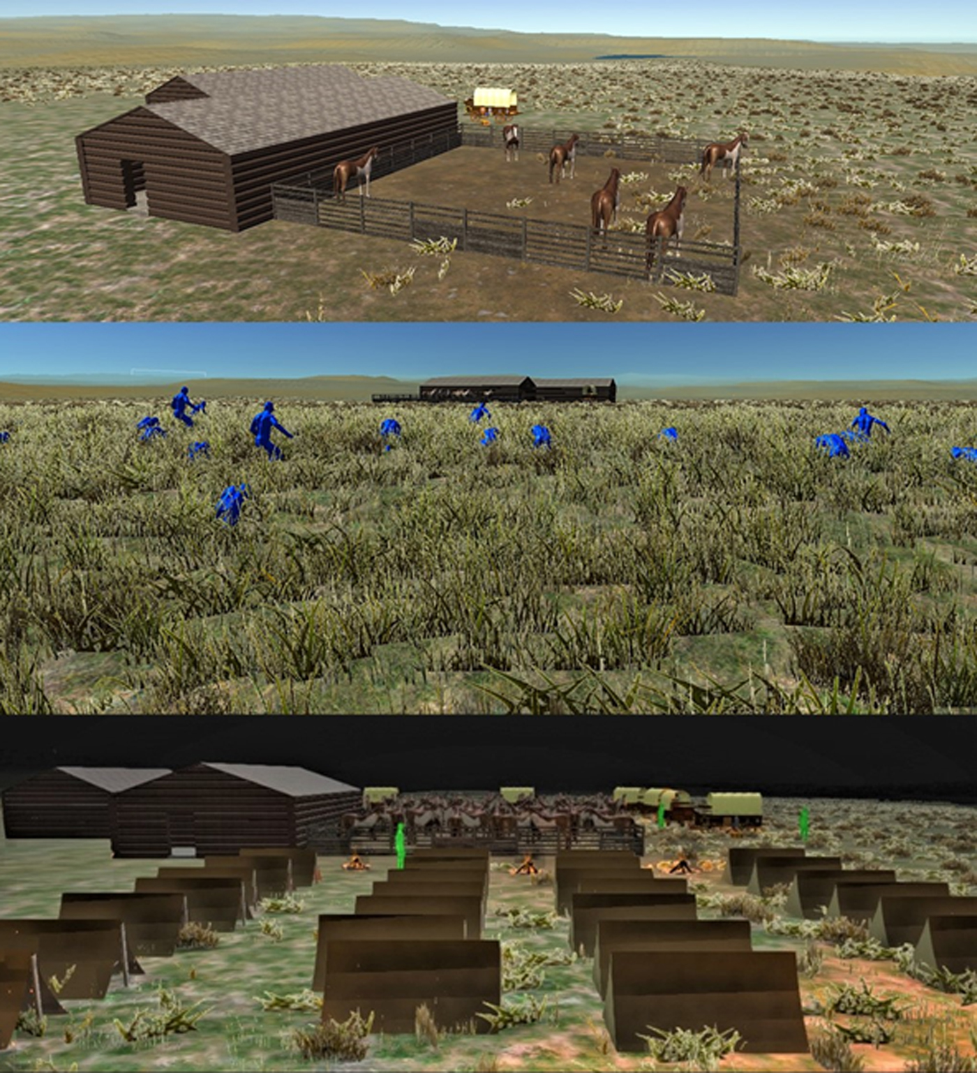
FIGURE 7. A composite image displaying different hypothetical scenes within the timeline established from the historical record. These and other scenes allow consideration of the assembly of the camp as well as the effects of the terrain on a first-person perspective of the two forces. (Images by the authors)
The primary and immediate result of the Mud Springs reconstruction was a graphic presentation of the tent camp. As a rendering, the presentation is, of course, hypothetical, but it is reasoned and linked to both archaeological and historical discoveries and our on-the-ground experience with the site. By providing a tangible presentation of life and events that transpired over a couple of cold days in 1865, the reconstruction is an interpretive presentation of the results of archaeological research carried out at the site. It provides viewers with an understanding of where significant events of the past took place but for which there are no physical traces. The information conveyed in the reconstruction provides details of the events with the ability to visualize the conditions of the camp as well as locations across the landscape over which key events transpired.
Beyond providing a visualization of the former station, temporary camp, and surrounding terrain, the reconstruction offered insights and information that could guide future research. The model presentation, for example, raises questions about the size of the tent camp, the placement and distribution of camp debris, and the overall extent of the area occupied by cavalry troops. The visualization also allowed us to recognize and consider such issues as cramped space and the difficulties of securing men and stock in an open area. The process of moving from documented base information (i.e., structure location and terrain) to a fully reconstructed camp provides a basis for speculative or hypothetical reconstructions. These portrayals of the camp do not accurately—in absolute terms—present how forces were arrayed at Mud Springs. Rather, we can use the process of negotiating between archival information, documents on military practice, and speculation to predict how archaeological materials might have been distributed at the site. Likewise, we can use the process of virtual camp assembly as a basis for discussing how the camp, and its ephemeral archaeological signature, changed over the course of its history. Indeed, the great strength of the presentations might be that they make it possible to address issues that would otherwise be overlooked In short, a virtual experience of place prompted us to consider conditions in the past. Addressing such issues exposed a new level of utility in operational manuals and sources such as contemporary descriptions of other frontier camps. These comparisons demonstrated how such sources could provide valuable, if general, background to the Mud Spring case.
DISCUSSION AND CONCLUSION
These case studies illustrate the dilemma concerning the public's access to archaeologically important places that lack a readily understandable, tangible heritage. Though our case studies reflect historic frontier heritage, the same predicament applies to the prehistoric record. In many circumstances, archaeological sites retain little in the way of a built environment. Through modern archaeological means and historic documents, we can document faint traces of the past and glean important information about the nature of life at those locations. Nevertheless, the lack of physical presentation hinders a tangible “prop and prompt” through which memory is maintained and heritage is communicated and experienced (Smith Reference Smith2006:2).
The VR models and method presented here represent one solution to this issue. Using affordable software and freely accessible information, a group of nonspecialists devised two workflows suitable to reclaiming lost heritage using archaeological and archival sources. In the case of Sulphur Springs, the resulting reconstruction helped to reclaim a town that had been lost in the tumult of relocating the community. The resulting document enables descendent communities to understand the layout and appearance of the former town while providing a deeper understanding of space and a connection to the former properties of specific individuals. Through active community involvement (e.g., through historic images and accounts) we continue to develop and refine the information presented. The result is an opportunity to continue local collaboration in maintaining and growing access to heritage.
In the case of Mud Springs, we combined archaeological information, the drawings of Lt. Caspar Collins, and historic accounts of both US forces and Cheyenne combatants to reclaim and reinterpret events at an isolated telegraph station in an early action that presaged the Indians Wars. With the resultant reconstruction, we can continue to develop our ideas of how the past unfolded and of the archaeological signatures we might expect under different scenarios of camp formation. The vantage afforded through the virtual environment provides an immersive experience through which to consider the camp and surrounding landscape. This is especially the case when one can actively move through the environment and consider the positions of the US military and Cheyenne throughout the battle and compare this to accounts provided by Cheyenne and US cavalry members. Visibility affected by topography was central to the events of the engagement, and the first-person experience of the reconstruction provides a clear and palpable connection to events that transpired on what today is an open and empty prairie. Because reconfiguring assets (e.g., tents, horses, and soldiers) is simple and fast, new ideas can be investigated, and scenes can easily be changed in light of new interpretations. This provides the opportunity to update the reconstruction as research provides new information, and as a public education tool, it offers flexibility not readily available in other formats.
Though these were just two historic case studies based on existing projects, the workflows we developed and describe here can be applied to diverse projects, including ephemeral heritage and more conspicuous sites. For example, one of the authors (ZD) has used the workflows devised from our student project to migrate a reconstruction of the Mayan site of Copan (previously in other formats; Von Schwerin et al. Reference Von Schwerin, Richards-Rissetto, Remondino, Agugario and Girardi2013) into the Unity game engine. The result provides a first-person perspective and, with the automation of vegetation and other environmental conditions, a fully immersive experience (Bennington-Castro Reference Bennington-Castro2017).
Likewise, the workflow has easy accessibility to recreating presettler archaeological sites. Ample evidence from excavation and other documentation can provide access to prehistoric lost heritage sites. As a case in point, one of the authors (ZD) is now working with colleagues to develop reconstructions of protohistoric Plains Indians villages in Kansas.
A primary goal of our project was to make this technology more broadly accessible to the public. Because information access and sharing has greatly increased and affordable technologies are available, there is a broader democratization in how knowledge is gained and produced, and this can challenge traditional approaches to learning and concepts of expertise. In archaeology, this has been especially obvious in the digital domain as recent advances have increased how heritage information is obtained and disseminated. Digital technologies are being broadly adopted and enable the rapid sharing of information with diverse audiences (e.g., Douglass et al. Reference Douglass, Kuhnel, Magnani, Hittner, Chodoronek and Porter2017; Grün et al. Reference Grün, Remondino and Zhang2004; Magnani et al. Reference Magnani, Guttorm and Magnani2018; Wahbeh et al. Reference Wahbeh, Nebiker and Fangi2016). In some respects, the traditional view of requiring specialists reflects twentieth-century thinking about a twenty-first-century process.
The information revolution has changed the way students of all ages and walks of life learn. The process we developed reflects a form of problem solving and tinkering while learning and doing rather than the application of existing skill sets. Because we didn't have access to trained specialists, we were forced to learn as we went, using online tutorials and clever students. This is the essence of experiential learning, and through this process, expertise was indeed gained.
The workflows that resulted from our efforts can be readily learned by diverse audiences, and continued development can help teach valuable skills in classrooms. The step-by-step video tutorials of the process shared on our website (https://www.unl.edu/plains/virtual-reconstruction-tutorials) provide simple and detailed instructions for those looking to replicate our approach on other projects. We are in the early phases of developing courses and training modules to reach diverse audiences and to continue refining our reconstructions. These training modules will be structured to suit the needs of university students and high school after-school programs and will not only cover the workflows involved but also consider ways in which these tools can be used to engage with the public about heritage.
This article and associated tutorials outline how we solved a problem. We had good data and an interested audience, but we had to determine how to share what we had learned without revealing sensitive archaeological information. We understood that virtual reconstruction was a viable way to share what we had learned, but we were not experienced in creating such products. By retelling our experience as a group of nonexperts who figured it out as we went, our aim is not to draw focus on the outcomes of our work or to highlight its continued development. Rather, these two studies reflect the addition of VR to communicate findings of more routine archaeological field projects. The message is thus not a story of high accomplishment but is better cast as an example of how regular archaeologists can benefit from and succeed in the use of accessible technologies. We hope that our efforts and experiences will spur similar projects and inspire local heritage groups. Indeed, we hope this work prompts further improvement to our approach. Most importantly, we hope that it provides a pathway for greater public involvement in reclaiming access to lost heritage.
Acknowledgments
We would like to express our thanks to the Center for Great Plains Studies for agreeing to host reconstructions and video tutorials. We are especially grateful to Katie Nieland and Rick Edwards for assistance. Work at Chickasaw National Recreational Area was made possible with a National Park Service grant through the Great Plains Cooperative Ecosystem Studies Unit at the University of Nebraska-Lincoln. No permits were required. Douglass, Day, and Brunette would like to thank the Murray County Historical Society and the citizens of Sulphur, Oklahoma, for their warm welcome and invaluable assistance. Likewise, we would like to thank NPS staff in Sulphur, and especially Noel Osborn, for helping to organize our research. This work would not have been possible without the assistance of Dawn Bringelson, Chris Nycz, and other staff at the Midwest Archeological Center; UNL graduate students Michael Chodoronek and Luke Hittner; and students in the UNL archaeological field school. The Mud Springs work involved Dr. Melissa Connor, then with the NWU Forensics Sciences Program; Professors Jerry Renaud and Luis Peon-Casanova of the UNL Broadcast program; and Steve Devore, William Altizer, Ben Barnette, Penny Berger, John Feltz, Katherine Lamie, James Lindsay, Pete Peters, Brian Schilz, and UNL field school students. The project was supported by a grant from the University of Nebraska–Lincoln Vice Chancellor for Research.
Data Availability Statement
The data used in this study are stored in digital format and are curated by the University of Nebraska–Lincoln (UNL). Presentation of the workflows presented in this project is provided through the Center for Great Plains Studies at the University of Nebraska and can be accessed through https://www.unl.edu/plains/great-plains-archaeological-virtual-reconstructions. This site provides contact information about further interest in the approach presented.


