


Historically and cross-culturally, communities have intentionally utilized vertical spaces, mountain peaks, and cliffs, frequently as sacred places and burial sites (Erickson 2006; Knabb et al. Reference Knabb, Mohammad and Levy2015; Man Reference Man1991; Reinhard and Ceruti Reference Reinhard and Ceruti2005). In times of rapid deforestation and environmental change, more archaeological sites, including these, are being exposed and are in danger of becoming damaged or lost if archaeologists are not willing to become more proactive. However, work in these contexts often requires new methods and training in order to document and acquire data (Church Reference Church1997; Evans et al. Reference Evans, Fletcher, Pottier, Chevance, Soutif, Tan, Im, Ea, Tin and Kim2013; Morales Gamarra et al. Reference Morales Gamarra, Alvarez, Church and Tello2002). Archaeological discovery, detailed study, and safety of practice in the documentation of these vertical spaces necessitate collaboration with professionals who can provide specialized techniques, equipment, and training to allow researchers to access, map, and excavate these historically important sites.
In Chachapoyas, Peru, the ancient peoples adapted their cultural practices to the precipitousness of the mountains of the Andean Cordillera. They constructed platforms to level slopes and terraces to prevent erosion of soils for agriculture and utilized distinct ecological zones at different elevations to fulfill a range of dietary and material needs (Brush Reference Brush1976; Schjellerup et al. Reference Schjellerup, Sorensen, Espinoza, Quipuscoa and Peña2003). In order to reconstruct these practices, we too must adapt our archaeological approaches to accessing and registering the remains left behind. These nearly vertical environments include natural hazards for archaeological practice and conservation, such as erosion and unpredictable tectonic processes that destroy remains on cliff faces. In this article, we describe and discuss the techniques of vertical archaeology developed in the Chachapoyas region of Peru and provide a case study from the mortuary complex of La Petaca. The goals of the Proyecto Arqueológico La Petaca (PALP) were primarily of reconnaissance, photographic registry, and select archaeological excavation in order to identify and map the distribution of structures, combining traditional methods of archaeological practice and rope access techniques. We describe the techniques used in vertical progression, where individuals use rope systems to rappel and move up and down along vertical cliff surfaces, as key to our practice. We argue that innovation and technical collaboration are necessary to reach these archaeological remains.
PREVIOUS METHODS IN ARCHAEOLOGY IN VERTICAL SPACES
Archaeologists generally explore flat terrain, following transects across landscapes to look for evidence of anthropogenic modification, and excavate defined units at controlled depths to recover materials from stratigraphic layers. When archaeological sites are not buried but remain uncovered due to their location, such as on exposed cliffs, in some cave environments, or deflated surfaces, archaeological methods must be altered. These types of sites can also pose personal safety concerns, since the surfaces available for standing or working may be limited, for example, or precipices may include long drops to levels below. Yet archaeologists have not been daunted by the challenges of these seemingly impossible to reach sites. High-altitude and alpine site exploration has been facilitated by mountaineering and alpinist techniques (Reinhard Reference Reinhard1985; Stirn Reference Stirn2014). Deep caves have also been investigated (Kambesis Reference Kambesis2007; McNatt Reference McNatt1996; Straus Reference Straus1990; Uomini Reference Uomini2016), some using spelunking methods and technology (Fabre Reference Fabre2008a; Wrobel et al. Reference Wrobel, Helmke, Freiwald and Wrobel2014), although the techniques used have not been the focus of publications on these investigations. More recently, innovative digital technology and GIS-based approaches have significantly enhanced topographical recording of the complexity of deposits in cave and rockshelter contexts (Herrmann Reference Herrmann2002; Moyes Reference Moyes2002).
There is a long history of early explorers and archaeologists finding materials on elevated and narrow ledges, but there is little explicit publication of methods, materials, techniques, and recommendations for working on exposed cliffs or using rope systems. Based on an illustration from one historical expedition, we see the use of rope technology for technical support, but the methods are unclear (Figure 1; Wiener Reference Wiener1880:207). Kauffmann Doig and Ligabue (Reference Kauffmann Doig and Ligabue2003) used ropes, harnesses, and suspended platforms to work, but they did not define these practices. We can imagine that many archaeologists in the Andes have climbed to sites without technical training, equipment, or methods but focused more on descriptions of the sites and materials recovered than if rope technology was used for safety (Koschmieder Reference Koschmieder2012). There is a significant void in published literature that links how these techniques could benefit archaeology. Our goal is to provide this link by defining some of the methods we used to work at sites along cliff faces in Peru.

FIGURE 1. Historical illustration by Wiener (Reference Wiener1880) of cliff tomb exploration using ropes. (Reproduced from Wiener Reference Wiener1880:207, https://books.openedition.org/ifea/7801)
The international rope access community, in addition to arborist and spelunking associations, have developed professional and technical standards and have published manuals (Cuenca Rodríguez et al. Reference Cuenca Rodríguez, Cainzos, González Ríos, Gómez, Molina, Julián, Lastra, Pérez, Trillo and Gottardi2000; Laman Reference Laman1995; Maher Reference Maher2006; Martí Puig Reference Martí Puig2013; McCurley Reference McCurley2016). Archaeologists may not be aware of such methods or may be working under conditions (lacking proper equipment or training) that prevent full adherence to such recommendations. Alternatively, projects may be in countries where these programs are not yet fully developed. The safety of both the team members and the site need to be considered as our presence and equipment can negatively impact the natural and historical contexts, especially if the methods are applied incorrectly (Henrikson and Camp Reference Henrikson and Camp2015). Finally, accidents can greatly impact the archaeological and environmental research as well as the local communities where these projects take place (BBC 2014; Ojeda Reference Ojeda2015).
THE VERTICAL ANDEAN WORLD
Some topographically extreme regions of the Andean cordillera can necessitate these vertical rope techniques. Verticality is one of the most spectacular features of the Andean world and has significantly influenced the civilizations that developed there. The complexity of the environment was both shaped by and exploited for economic, social, and ritual purposes (Bolaños Reference Bolaños2010; Ceruti Reference Ceruti and Schobinger2001). Most human settlements are at lower elevations (below 3,500 m asl) on plateaus or relatively flat areas, but across time periods, we also see higher elevation occupations. Agricultural practices (e.g., terracing) and architectural features (e.g., retaining walls) were developed for stability and durability along steeper slopes. Even in more moderately mountainous regions, rivers have cut deep valleys and created high, almost vertical cliff walls where we find archaeological evidence of constructions (most often tombs). A number of sites across the eastern Andean slopes have been explored with a focus on how these vertical landscapes were transformed and their role in ritual and mortuary practices (Herrera Reference Herrera, Kohring and Wynne-Jones2007; Mantha Reference Mantha2009).
Karstic geographic regions, with cliffs and caves, have great potential for vertical archaeological methods. Caves, especially in the northern Chachapoyas region, are often surveyed by spelunkers whose goals include exploration, definition, and mapping (Guyot Reference Guyot2008). These explorers examine geological and hydrological features but have often provided little detailed scientific research or publication of the archaeological remains other than to identify them as present or absent. It is clear that ancient human groups, possibly some of the earliest occupants of the region, used caves or rockshelters for a variety of purposes (Church Reference Church2004), especially mortuary functions (Fabre Reference Fabre2008b, Reference Fabre2008c; Ruiz Estrada Reference Ruiz Estrada2008). They also appear to have entered into the cave systems to profound depths where we find evidence of their activities (Fabre et al. Reference Fabre, Guyot, Gismondi, Pizarro and Maniero2008). More work needs to be done systematically, including archaeological analysis alongside these geological and hydrological investigations, as there is a dynamic relationship between humans and caves in many areas. The understanding of the nature and history of use of these subterranean spaces is currently limited, but research collaborations are advancing (Martí Puig Reference Martí Puig2004).
Professional teams from Spain (Grupo EspeleoKandil, http://www.espeleokandil.org/; Proyecto Ukhupacha, http://ukhupachaonline.blogspot.com/), France (Groupe Spéléo Bagnols Marcoule, http://www.gsbm.fr/), and Peru (http://cuevasdelperu.org/espeleologia-peruana/) have increased exploration of the Chachapoyas region, contributing to archaeological practice in addition to providing training for other professionals, including hydrologists, spelunkers, geologists, and biologists, and local citizens interested in caves.
ENVIRONMENTAL AND ARCHAEOLOGICAL CONTEXT
Located on the eastern slopes of the Andean mountains in the Quechua and Jalca ecological zones between 2,000 and 3,500 m asl (Pulgar Vidal Reference Pulgar Vidal1967), the ancient Chachapoya (AD 900–1470) constructed occupational centers, terraced agriculture, and mortuary sites along slopes and ridges. The Chachapoyas region is defined by a suite of archaeological features found in the encompassing area cut longitudinally by the Utcubamba River and bordered by the Marañón River to the west and tributaries of the Huallaga River to the east (Figure 2). These major rivers run at lower elevations through more temperate ecological zones and eventually unite with the Amazon River. This tropical forested and mountainous environment is built up of Triassic and Jurassic period rock formations that are primarily limestone layers with occasional volcanic tuffs and basaltic inclusions (Schjellerup et al. Reference Schjellerup, Sorensen, Espinoza, Quipuscoa and Peña2003). The topography is dramatic and steep. The scarcity of level terrain, shallow topsoil, and unstable soils at lower elevations make agricultural practices, including the cultivation of maize and other staple crops, challenging. However, major archaeological settlements on plateaus suggest that the prehistoric region was once fairly densely occupied (Church and Valle Alvarez Reference Church and Alvarez2017; Koschmieder Reference Koschmieder2012; Schjellerup Reference Schjellerup1997).

FIGURE 2. Map of the Chachapoyas region and location of La Petaca. Red stars indicate Chachapoya period sites and yellow stars Inca period sites. Red circles identify main mortuary complexes. (Main map credit: J.M. Toyne. Inset after Guengerich Reference Guengerich2014:81)
Chachapoya archaeology has been advancing over the past 20 years (Church and von Hagen Reference Church, von Hagen, Silverman and Isbell2008). Mortuary archaeology in particular has derived considerable interest (Crandall Reference Crandall2012; Kauffmann Doig and Ligabue Reference Kauffmann Doig and Ligabue2003; Nystrom et al. Reference Nystrom, Buikstra and Muscutt2010; Ruiz Estrada Reference Ruiz Estrada2009; von Hagen and Guillen Reference von Hagen and Guillen1998), but few detailed scientific investigations have been published. The Los Pinchudos project by Morales Gamarra and colleagues (Morales Gamarra Reference Morales Gamarra2002; Morales Gamarra et al. Reference Morales Gamarra, Alvarez, Church and Tello2002) stands out as an investigation of an incredible mortuary complex; however, their research publications focus more on architecture and conservation rather than detailing methods used to access the tombs. Significant site damage from both natural and anthropogenic (looting) processes has deterred some researchers. Moreover, many of these mortuary complexes are in remote localities and situated high on rock escarpments. Although we may have assumed these conditions would discourage looters, there is evidence for both precolumbian and more recent ransacking with various methods used to gain access. Despite these challenges, recent bioarchaeological research using recovered human and mummified remains has provided invaluable access to information about the lives of these past peoples in spite of limited and highly commingled collections (Epstein and Toyne Reference Epstein, Toyne and Osterholtz2015; Koschmieder and Gaither Reference Koschmieder and Gaither2010; Toyne et al. Reference Toyne, Church, Tello and Gamarra2017).
La Petaca
The La Petaca necropolis is located approximately 14 km south of the modern community of Leymebamba (Figure 2). It is located at 3,300 m asl above a narrow ravine, which is oriented approximately south to north and joins the Tambillo and later the Atuen Rivers. All along these river systems are strategically located archaeological sites including occupational centers (La Joya, Monte Viudo, La Boveda), numerous small rockshelters, and mortuary sites (Guengerich Reference Guengerich2014, Reference Guengerich2015; Muscutt Reference Muscutt1998; Schjellerup Reference Schjellerup1997). Our investigations of the mortuary spaces complement research at these sites, but associations between tomb use and habitation sites are challenging even though they are contemporaneous, as there are few direct links among specific sites.
La Petaca is unique in that it is not a buried complex. The ruins of the tombs are exposed on the narrow ledges of a large natural rock escarpment (Figure 3). There are various sectors separated by areas of vegetation, which we defined as Northern, Central, Southern, and Upper, covering an area of approximately 500 m from north to south and 120 vertical m. There are other exposed rock faces nearby and below, but these do not have visible archaeological structures. Mapping using traditional topographical techniques results in a “width,” or depth, of approximately 40 m from the uppermost ledge to the lower ledge since the wall is generally convex. The resulting plane map shows levels with structures that are almost superimposed. The Southern sector is the largest area with abundant evidence of tombs and was the focus of our investigation in addition to a few structures on the slightly easier to reach Upper sector (Figure 3).
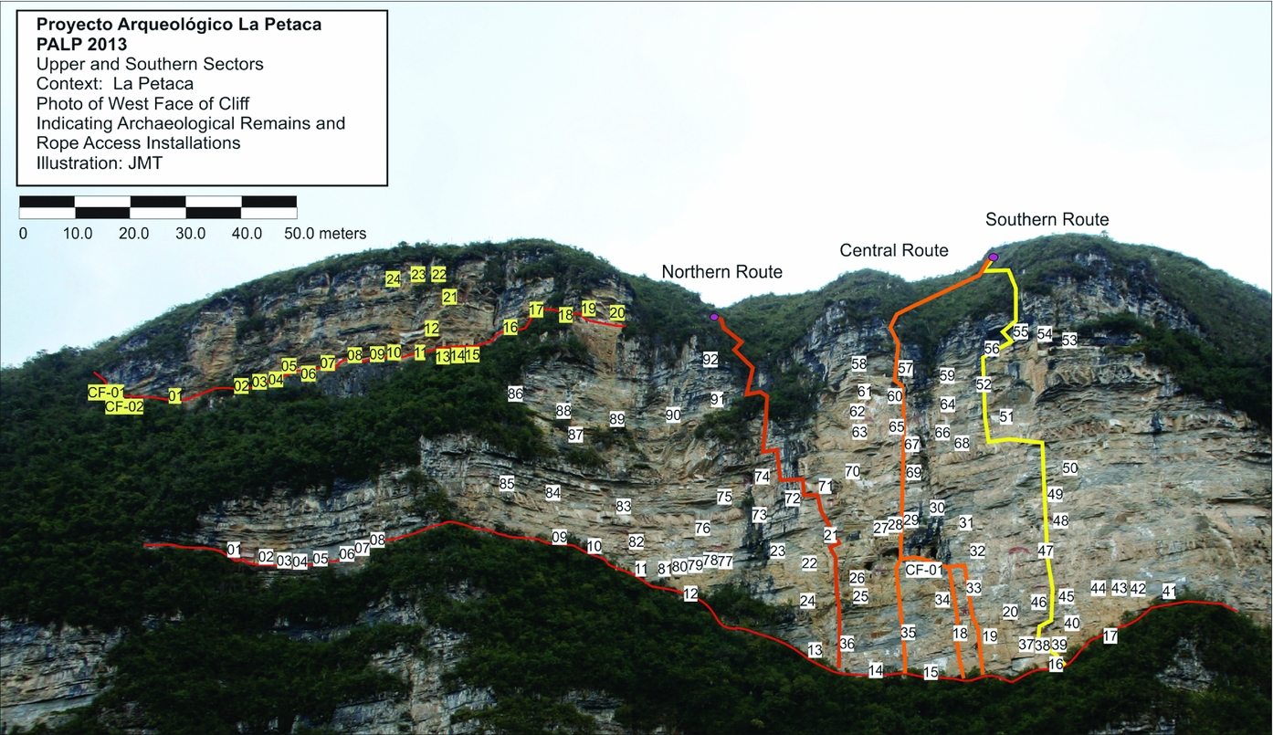
FIGURE 3. Upper and Southern Sectors of La Petaca with rope access systems (horizontal railings in red and vertical rope transects in dark orange, orange, and yellow) and identified archaeological structures (yellow for Upper and white for Southern). (Photo credit: J. M. Toyne)
OBJECTIVES OF ARCHAEOLOGICAL RESEARCH
The 2013 Proyecto Arqueológico La Petaca (PALP) focused on the documentation, excavation, and sampling of the mortuary site of La Petaca to provide the first scientific exploration of these remains to examine their history and cultural significance. Although the site is well-known for its rock art (Muscutt Reference Muscutt and Hedges1987, Reference Muscutt1998), previous registration of the site only included long-distance photography. The cemetery function was inferred after previous visits by locals and other groups who had systematically removed mummified human remains from various structures. This was also similar to other mortuary sites in the region. Radiocarbon dates from materials recovered from tomb architecture and contents reveal a long history of use from AD 900 to the 1600s (Table 1; Epstein and Toyne Reference Epstein, Toyne and Osterholtz2015).
TABLE 1. Radiocarbon Dates for Selected Contexts at La Petaca.

Note: Dates from INTCAL13 using Hogg et al. Reference Hogg, Hua, Blackwell, Niu, Buck, Guilderson, Heaton, Palmer, Reimer, Reimer, Turney and Zimmerman2013; Reimer et al. 1993
For site registration and documentation, our goals were ideally to systematically access as many structures as possible. Based on the conditions, we were significantly limited by time, personnel, and safety measures. We used archaeological methods including photography and line drawings of plans, sections, and features of each structure, and we sampled building materials and remains found on the surfaces. We also used a Total Station with a stadia rod and prism and handheld GPS to take 3-D points for each structure in order to map the layout of the site. We proposed limited excavations based on time and accessibility to select structures. Since few artifacts remained, we collected osteological human remains for analysis to reconstruct demographic and paleopathological features that might support interpretations of the mortuary samples’ origins (Anzellini Reference Anzellini2016; Epstein and Toyne Reference Epstein, Toyne and Osterholtz2015; Toyne and Gonzales Valencia Reference Toyne and Valencia2014).
Professional Technical Support
With our archaeological research objectives, the process of determining the most appropriate approach and techniques needed to be evaluated by those knowledgeable in exploring vertical spaces. The collaboration with Asociación Ukhupacha, a group of spelunkers and professional first responders from Spain, had begun in previous years. The team members are experienced in cave exploration and rope rescue but have also been working with archaeologists in Peru at various sites such as Machu Picchu (Puig Castell Reference Puig Castell and Villavicencio2011). For this investigation, we determined that a minimum team of at least four individuals was necessary to train, establish routes, and provide technical support to the working archaeologists. Over the course of the field project, we had a total of eight members on site at various times.
Once the most feasible approach had been determined, accessing the site safely was the priority. The rocky terrain was challenging, and carrying additional equipment affected normal dexterity. It was necessary to have the proper personal gear such as helmets, gloves, and harnesses. The rest of the equipment was determined based on the space being explored and the methods necessary. This will be described further below.
The technical crew established the access points to the areas where we planned archaeological interventions. They determined the pathways, including starting points, staging areas, and the interconnecting rope systems. Vertical progression is a method developed for the exploration of deep cave shafts where individuals can displace themselves vertically regardless of the inclination of the wall or the distance above a flat surface. These methods were developed in the past century by Edouard Alfred Martel who began the first scientific spelunking expeditions in France and since the 1960s have evolved with the development of new innovations in rope fibers, carabiner fabrication, and anchor systems, all of which make vertical progression more efficient and safer (Puig Castell Reference Puig Castell and Villavicencio2011). Caving and mountaineering techniques are considered sport methods but have been adapted to industrial purposes and standards with more of a focus on safety and fall prevention.
In addition to safety, equally important was identifying those methods that would limit our impact on the natural and cultural environments. Since new pathways had to be cut through vegetation using a machete, it was important to minimize the disturbance. It was necessary to drill holes into the rock surfaces to place anchors, but under guidance from on-site archaeologists, the technical team chose locations that did not damage cultural resources (Figure 4). Ropes were wrapped in rope guards to prevent abrasion in areas where they unavoidably came into contact with architecture. We also avoided stepping on tomb walls and interior surfaces of the chambers as much as possible; however, they were often the only flat surfaces available.

FIGURE 4. Team member placing an anchor using a mechanical drill. Inset shows anchor bolt in rock surface. (Photo credits: J. M. Toyne)
METHODS
Vertical Progression Equipment, Techniques, and Training
Approaches to moving and working in vertical spaces (rope access) have been developed for various commercial, scientific, and recreational uses, and there is some variation in the equipment and techniques utilized (McCurley Reference McCurley2016). The methods for archaeology in vertical environments draw on spelunking rope access methods, not sport climbing or alpinist trekking systems. The rope-based methods used in vertical progression focus on the individual being totally suspended and able to ascend and descend along rope systems manually, with limited direct contact with the rock face. We adapted the dual protection rope system employed by rope access technicians throughout the world. It is a completely interchangeable two-rope system where one rope is designated as the primary, or working, rope and the other is designated as the backup, or fall prevention, rope (Adams Reference Adams2007).
Each individual had the appropriate basic personal equipment necessary, including 1) protective outer clothing, helmet, industrial full body harness, technical gloves, hiking boots, and ankle gaiters; 2) ascending systems including a foot loop, hand ascender on a lanyard, and chest ascender; and 3) descending systems including the Petzl I'D descender and double-tail safety lanyard. The personal safety equipment was selected according to industrial safety standards in order to provide the most stable harness with only minor mobility limitations. We also employed the Petzl ASAP rope security lanyard technique as backup on the secondary rope (Haefke et al. Reference Haefke, Spiers, Miller and Lowman2013).
The materials used for the rope systems are listed in Table 2. Static rope is preferred over dynamic rope since we did not want the elastic give in the rope to create a bouncing effect while ascending. Static rope is also more energy efficient for the user during vertical progression. Since the anchors withstand variable mechanical forces and loading, we selected different types, and depending on the rock substrata, we alternated between the multi-multi bolts (which are drilled by power tool and removable) and spits (which are hand-drilled, expanding bolts that are placed in existing cracks) (Figure 4). Equipment also included large waterproof packs for carrying rope and hardware as well as a rechargeable power drill, a hand drill, and a hammer for placing bolts.
TABLE 2. List of Rope System Equipment.

We worked in pairs, and each individual had a walkie-talkie to communicate with each other as well as a colleague across the valley taking topographic points with the Total Station. In this setting, where rock stability was uncertain and the height was significant, two pairs of technicians were used. While one team was placing anchors, the other was available in case of emergency. This increased the project budget (transportation, room and board) even though the rope specialists volunteered their time for the project.
The five archaeologists were trained by the Ukhupacha professionals. While these techniques had been developed by spelunking and industrial professionals (Martí Puig Reference Martí Puig2013; McCurley Reference McCurley2016), there were some adaptations necessary to the specific site where we were working and also based on the physical skills of each individual. We spent two days training with equipment and ropes in the local community prior to heading out to the archaeological site for 15 days. We established practice rope systems on a local bridge so that we could be suspended at least 5 m above the ground and learn the basic techniques for ascending, descending, and working while suspended.
The professional technicians established the rope installations, drilling and placing anchors and attaching rope lines across the site, and remained present during the entire project to facilitate rope access and safety. They secured an initial starting anchor point at the top and then, using various anchors, established a belay system with multiple contact points down the rock façade. If no anchors were placed and the rope was left to hang freely, it would dangle some distance away from the base ledge and also ensure that only one person could be on the rope at a time. Without the re-belay anchors, the suspended individual would be several meters away from the archaeological remains on the cliff. With little to stabilize them, the suspended individual would spin around on the rope, making archaeological photography and assessment a problem. Individuals may begin at the top of the installation and rappel down the rope, or begin at the base ledge and climb up the rope using their hand and foot ascending system. The individual would also have to “pass” over the re-belay anchors, a technique called fractionation, where the individual momentarily was off rope before reattaching above the belay point, so fewer anchors are preferred. Generally, the movement was in a single plane (up and down), but rope systems could also be anchored horizontally across vertical surfaces, and suspended individuals could then move sideways across those rope systems. By installing ropes both vertically and horizontally, it was possible to reach directly any point on the archaeological site in total security. Importantly, this was a temporary system, meaning that all materials embedded in the rock were removed afterward, and little trace of our installations was left visible.
The location of each anchor point in the cliff was determined based on rock substratum quality. Since this is a sedimentary limestone geology, many strata are quite fragile, and it took time to identify a solid placement for anchor bolts. This meant that the vertical installations were not straight transects but often deviated along the path as we searched for exposed harder limestone rock layers or possible basalt layers. Anchors also needed to be placed as close to archaeological remains as possible but not impact them or place ropes in direct contact with architecture. If the ropes rubbed on surfaces, this could not only damage the archaeological remains but also compromise rope integrity.
To access certain areas, it was possible to climb down to narrow ledges and along trails in areas with less steep gradients. The vegetation included grasses, small shrubs, and few small trees, which in some cases were only shallowly rooted into the cliff surfaces; most could not be relied upon for stable natural anchors. The lower base ledges could be reached in this manner, but the descent was precarious and slippery, and the ascent was physically challenging, especially carrying archaeological materials. Therefore, we determined that rope systems along all access trails were necessary, and we were always secured to a rope system whenever moving across the cliff wall.
Horizontal Railings
Even when we could walk along natural ledges, most were quite narrow. The base ledges could be as wide as 2 m across or as narrow as 0.5 m across. There were many archaeological structures, some taking up most of the narrow ledge, but there were also substantial loose shale rocks that made walking on the ledges dangerous. We installed rope railings that were bolted to the rock façade at various intervals. Across the Upper sector, we installed 150 m of static rope across the 125 m ledge, and an additional 80 m to reach the lower ledge of the Southern sector through a thickly vegetated slope. Along the Southern sector, we placed another 180 m of static rope railing along the ledge. These railings were also important at the specific structures we selected for documentation and excavation. We could carry out the archaeological tasks and were also always connected to a secure anchor using a lanyard (Figure 5a).
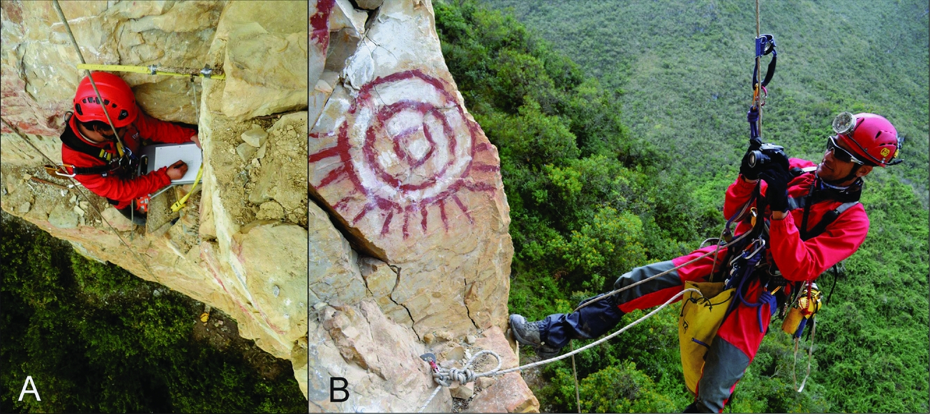
FIGURE 5. Archaeological documentation process. A) Producing the technical drawing of the entrance to the tomb chamber, and B) photographing architecture and rock art iconography. (Photo credits: J. M. Toyne)
Vertical Progression Installations
Initially, we idealized a grid based with a systematic series of rope lines 10 m apart following the model of traditional archaeological transects at horizontal sites. However, the natural geology and topography presented challenges even in the installation of a single vertical rope system down the approximate center of the Southern sector. The goal then became to place at least three vertical transects that would allow us to visit as many archaeological structures as possible. We placed a Central line, and then a Northern and Southern line. Figure 3 illustrates the location of these lines and how they are not necessarily straight or direct routes but have several horizontal re-belays. The Central route was approximately 85 m high using 160 m of static rope with 13 anchor points from the top to the lower ledge. Off of the Central line, there was a 25 m additional route (90 m of rope and three anchors) so that we could access important structures and the major panel of rock art at structure EF-18 (Figure 6). The Northern route was approximately 75 m high using 170 m of static rope and 31 anchor points, and finally the Southern route covered 87 m of rock face using 170 m of static rope and 34 anchor points. The more anchors placed reflected the greater difficulty of the route as well as the additional horizontal re-belays. While we could get close to many structures, we were only able to see them from that single plane for photography or taking a single georeference point using the handheld GPS or Total Station. We did not try to access every platform, as we were uncertain whether some ledges were stable enough to hold our weight. Some structures had masonry walls that were quite solid, but others were unsteady.
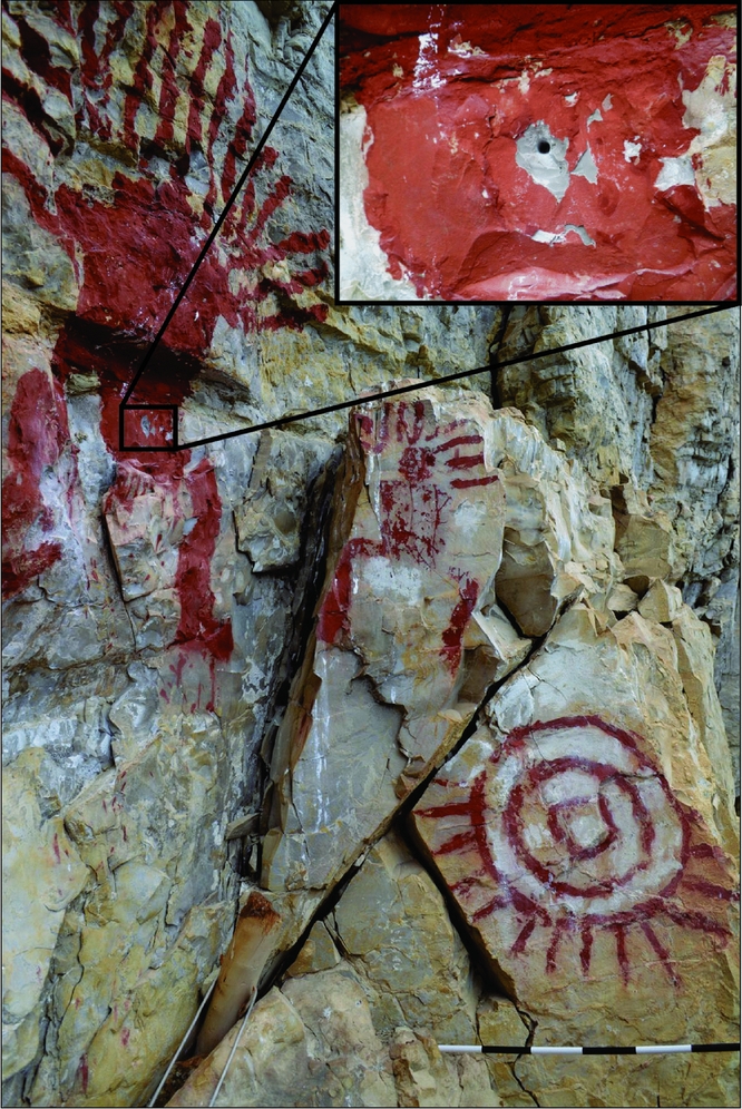
FIGURE 6. EF-18, a mortuary structure with distinctive anthropomorphic rock art painted in red above the tomb including three human figures (one of which is not pictured) and a sun (scale 1:10 cm). Inset demonstrates damage to paint due to a bolt hole placed by previous explorers. (Photo credit: J. M. Toyne)
We knew that we were not the first to access this necropolis using rope access techniques, but we were the first to record our work scientifically. We identified a previous anchor hole that had been placed directly into the pictograph of one of the anthropomorphic individuals in the center of Southern sector (Figure 6). The type of hole and a remnant of the steel bolt left in situ was recognized as a technique used by alpinists in the 1980s and 1990s. However, it is hard to imagine why any professional would place a bolt in that location causing irreparable damage to the pictograph.
PROJECT RESULTS
We identified 125 structures across the Southern and Upper sectors of the cliff wall of La Petaca. Via rope access systems, we documented seven structures in detail (Figure 5a and 7), including three shallow caves. We photographed and completed multiple technical illustrations for each, in addition to conducting surface recovery of remaining archaeological materials. We determined that many structures were located across six naturally occurring ledges. The range in mortuary variation suggests that there were chronological changes in how the tombs were constructed and/or that various communities may have been responsible for individual tomb construction (reported in more detail in Toyne and Anzellini Reference Toyne and Anzellini2017).
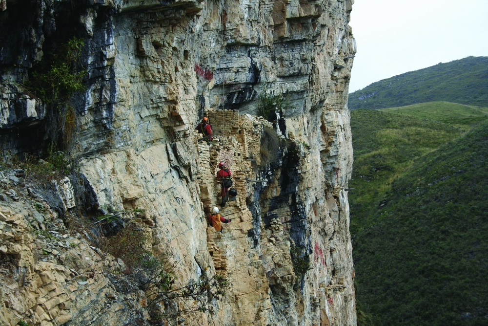
FIGURE 7. Team accessing mortuary structures (EF-21) showing vertical profile of rock escarpment. (Photo credit: J. M. Toyne)
DISCUSSION
The specific needs for archaeological investigations require documentation and recovery of spatial information of artifacts, architecture, and cultural modification of the landscape. Large datasets allow researchers to move beyond case studies to explore broad chronological and regional patterns. In the Chachapoyas region, archaeological research has been limited by the challenges of the verticality of the environment. Besides safety concerns, when attempting to access cliff tombs, there are also natural, cultural, and communication logistical issues.
During this field season, we achieved our goals by incorporating vertical progression rope access methods in order to access and document the mortuary site of La Petaca. There were no major equipment failures nor any close calls with technical issues or accidents. The only personal injury was a sprained ankle due to the rough terrain.
Archaeologists were trained to work on the ropes, allowing safe movement along pathways and vertical routes to the archaeological structures, but also allowing independent control to perform a variety of archaeological activities. With three vertical rope installations, we had access to a fair number of mortuary structures that were located at variable elevations across the cliff. While there were many on the lower ledges reachable via hand railings, if we had not been able to ascend to those on the higher ledges, we may not have been able to define the six mortuary levels. Nor would we have been able to examine the anthropomorphic rock art in detail (Figure 5b and 6).
Once near a tomb, we were able to place ourselves in a stable position to photograph and record many of the structures up close and identify specific details in the architectural features, materials used, and constructive techniques. This allowed us to gather a great deal of data on the variation in mortuary structures across the façade of the Southern sector, as we were not restricted to one area. These vertical transects were also baseline data for a topographic and georeferenced reconstruction of the exposed escarpment and the structure locations on it.
We were successful in taking measurements and creating line drawings and illustrations of at least one profile (the entrance) per structure, as well as plan layouts of several. We were able to map several that were high on the cliff face along narrow ledges (Figure 7). In those cases, sectional drawings were not possible, nor were additional façades. These drawings recorded morphological and artistic details as well as metric variation in different tombs.
We were able to transport the equipment necessary for archaeological excavations up to the structures and also to remove selected materials to the base ledges. We collected samples for radiocarbon dating, as well as human skeletal and animal remains to investigate demographic and biological features of those interred in the different tombs. These were packed carefully in cushioned sacks and lowered along the rope systems. All of these materials were carried back to camp and then to the laboratory for analysis.
We identified specific taphonomic factors affecting these remains across the site, including natural, geological, and cultural processes. Surprisingly, birds were a significant factor, after geological fragmentation and erosion. Large birds of prey, including eagles and condors, built massive nests on the architectural platforms not only using local vegetation but also incorporating textiles and other organic archaeological remains. Their feces stained archaeological surfaces, and smaller birds also pecked holes into the plaster surfaces of structures. Other animals included bats and smaller rodents whose feces were also widespread, and evidence of chewing and gnawing on bones attest to their destructive activities as well.
Limitations
The environment, the techniques, our skills, and the archaeological remains all influenced the amount of research that could be accomplished. Nearly constant rain made some surfaces with vegetation slippery, and days of direct sunlight on the western facing façade made conditions uncomfortable as well. The vertical environment meant that we were always exposed to the danger of falling materials. We aimed to limit the amount of direct contact with the structures and other archaeological remains. Due to the unknown stability of the natural rock ledges, we were required to be engaged on rope at all times and to move carefully across surfaces. Only a few items were dropped and lost (line levels and pencils), since we directly attached archaeological tools to our harnesses via string.
At the same time, we aspired to reduce the impact on the plant and animal communities with the technology we used and the locations that we accessed. Studies have been conducted in other areas where sport climbing occurs to quantify the impact of recreational activities on natural ecosystems (Camp and Knight Reference Camp and Knight1998a, Reference Camp and Knight1998b). Henrikson and Camp (Reference Henrikson and Camp2015) explored the impact of climbers on federally managed cultural resources in the United States and found that archaeological sites located at the base of exposed cliffs used for climbing staging areas demonstrated significant de-vegetation and erosion. We occasionally removed some vegetation to clear surfaces for rope access, but overall this practice was limited to the three vertical installations. We also relocated loose rocks to avoid contact that could cause them to fall down later, but we did not remove archaeological building materials. Interestingly, the trails created by our daily passage over the 15 project days were all but erased through natural regrowth when we revisited the site three years later. Finally, since there were also nesting predatory birds on the cliffs, we endeavored to select routes that avoided their current nest, but our nearby presence agitated them into hovering.
Time was limited, and working with a professional crew requires time for training, system installation and removal, and support during archaeological work. A great deal of preparation goes into establishing the vertical access systems to make sure they are safe and located in the most productive archaeological areas. However, the geologically fragile rock substrata also limited where secure anchors could be placed, which then may have located the rope access in an area where photography was difficult or archaeological remains could not be well documented. Therefore, there were areas of the site that were not as well observed as planned. At the same time, the unknown stability of the structures meant that standing or sitting on ledges was dangerous.
The training of the archaeologists was adequate for our basic needs to ascend and descend to ledges and structures, but it did not provide us with the ability to modify our location. More training and experience in rope access techniques would help remedy this issue. Moreover, the physiological challenges of working above 3,000 m asl (a moderately hypoxic environment) cannot be underestimated in terms of limiting daily physical abilities.
While the rope installations provided access, they also placed limitations on what could be done archaeologically. Handheld GPS recording was stymied by a limited number of satellites in the region during the project, and also due to the close proximity to the wall, which would block half of the available sky and satellites, creating a large signal shadow error. The signal would be lost or bounce off of the rock and provide coordinates located in the air above the ravine. The Total Station was a valuable tool for recording the geometric coordinates of the different structures, but we were unable to record multiple or detailed points for each structure due to the Total Station's distance of over 300 m across the ravine from the wall. For the structures located along the bottom ledge that could be accessed by walking and horizontal rope railings, we could place the handheld prism at points for each structure. However, for those structures that were higher up the exposed cliff face, a technician had to position himself holding the prism. Since there were only three vertical transects, we were not able to reach structures located any distance from the ropes. In the end, only a limited number of GPS and Total Station points were successfully located to produce a rough topographical map of the site.
FUTURE CONSIDERATIONS: TRAINING, TECHNOLOGY, AND NEW SITES
To continue this project at La Petaca, we will use similar methods as well as enhance training and proficiencies of crew members to allow more independence in moving across the vertical spaces. It would be ideal for archaeologists to have sufficient training to install rope access systems or to have cross-trained rope access professionals who could perform the more detailed archaeological documentation tasks (Martí Puig Reference Martí Puig2013). We propose using individual seated platforms (bosun's chairs) or developing rigging for larger platforms similar to those used by industrial window washers, thus creating a stable work station suspended in front of archaeological structures.
Additionally, recording and documenting techniques including digital mapping applications and photography (3-D photogrammetry) (Douglass et al. Reference Douglass, Lin and Chodoronek2015) can be improved through innovative and novel methods such as GoPro imaging. Unmanned aerial vehicles (drones) for digital documentation (Smith et al. Reference Smith, Passone, Al-Said, Al-Farhan and Levy2014; Wernke et al. Reference Wernke, Hernández, Marcone, Ore, Rodriquez, Traslaviña, Averett, Gordon and Counts2016) would provide the ability to photograph and record the entire surface at a fairly close range. However, it would not allow other archaeological recovery techniques, nor would it allow the human element of experiencing and identifying unique features.
With the broader goals of identifying and exploring new sites in the region, we recognize that each context requires initial survey to determine the materials, methods, and rope skills necessary. The underlying rock strata, covering vegetation, and access routes may present completely new challenges even within the same area. Yet, in the Chachapoyas region of Peru, there are many mortuary sites already identified and significantly looted that have not been archaeologically documented. The extensive cave systems with archaeological remains also require similar adaptations of archaeological methods to subterranean exploration.
For researchers interested in accessing archaeological sites that are located in vertical or cave environments that require specialized techniques and training, it is highly recommended that they consult with professionals, possibly in the region where they are working, to assist in research. There are often safety issues that require extra training, equipment, or supervision that we might not be aware of. We would not advocate rappelling on cliff faces using recreational or improvised equipment and techniques, or “just exploring” on one's own without any technical support. There are many professionals from various sources, including industrial, commercial, competitive, military, and first response, and highly trained recreational spelunkers who could participate in an archaeological project. The cost of working with professional teams might make this approach untenable for some, but preventing damage and documenting these endangered sites is worth the expense.
CONCLUSION
For the Chachapoya of Peru, these “dangerous” elevated spaces clearly had spatial and special meaning to local communities as burial places. Their construction and natural preservation provide a unique opportunity to explore and document these mortuary landscapes, yet the nearly vertical placement on cliff faces prevent the use of traditional archaeological approaches. Increasing exposure of these locations challenge archaeological investigation and preservation efforts as natural processes and looters are dramatically impacting these sites. Another key issue is personal safety, and for this project, PALP 2013 at La Petaca, we significantly benefited from the collaboration with professional specialists by incorporating vertical progression rope techniques with archaeological methods on these rock cliffs.
Acknowledgments
This project would not have been possible without the collaboration of the Asociación Ukhupacha's Salvador Guinot Castelló (director), Jordi Puig Castell, Ismael Mejías Pitti, Javi Sanz Borras, Felipe Sacristán Arnold, Iñaki Sáez Mentxakatorre, Millán Girón Sánchez, Patric Voguín Pacheco, and Liliana Bandenay, who are affiliated with and supported by Universidad Jaume I in Castellon, Spain. We thank the Peruvian archaeologists Willy Chiguala Villabuena and Danny Daniel Gonzalez Valencia, and we acknowledge the support of the regional Ministry of Culture–DDC Amazonas, its director, and staff, including Manuel Malaver Pizzaro and Jorge Chiguala. Archaeological excavations were authorized under the Peruvian Ministry of Culture permit RD No. 282–2013-DGPC-VMPCIC-MC. We thank Keith Muscutt, Warren Church, and Anna Guengerich for fruitful discussions, and the Department of Anthropology at the University of Central Florida (UCF) for their assistance, as well as Deborah Ziel. J. Marla Toyne thanks Clifford Freer for editorial suggestions. Funding for PALP 2013 was provided by the UCF Department of Anthropology, UCF College of Sciences, and the Petzl Foundation (France), as well as equipment support from MonVertical Inc. (Peru). We appreciate the comments of the editor and three anonymous reviewers whose suggestions were very helpful in improving this article.
Data Availability Statement
No original numerical or statistical data were presented in this paper.


