


The archaeological record of eastern North America is immense and widely distributed—as is the region's modern population. Archaeologists, however, are few and thinly scattered. Professional archaeologists are not alone in collecting prehistoric artifacts that lie on the ground's surface. From a narrow professional perspective, surface collection is a rigged game. There are many and widely distributed collectors who live near and/or travel through landscapes rich in surface artifacts. These collectors—many of them responsible and responsive stewards (RRS; Pitblado et al. Reference Pitblado, Shott, Brosowske, Butler, Cox, Espenshade and Neller2018, this issue)—are well placed, literally, to collect ground-surface artifacts regularly, and the overall distribution of archaeological finds is influenced by the distribution of the modern population (Shott Reference Shott2002). We archaeologists are many fewer in number, much more patchily distributed, and often burdened with other duties (such as teaching and contract administration) that severely limit our ability to travel, survey, and collect.
Across eastern North America, in the aggregate, collectors hold a vastly greater proportion of significant components of the record, especially the “arrowheads” of popular culture or the “projectile points” of archaeological discourse. A rare investigation of the share of points held by the professional community and by private collectors favored the latter by a ratio of over 30:1 (Shott Reference Shott2017)—a conservative estimate that ignores past generations of collectors. Professionals control roughly a 3% sample or less of this informative artifact type. A well-designed sample of 3% of very large populations might be representative. But our samples are uncontrolled for prior collection of the same locations and for circumstances that defy intelligent sampling design. We go where the projects are, especially in cultural resource management (CRM), and we are often consulted late in planning, work under less than optimal conditions, and survey in single passes only (Nolan Reference Nolan2020; Nolan et al. Reference Nolan, Leak, Quimbach, Shott, Seeman and Nolan2018; Peacock and Rafferty Reference Peacock, Rafferty, Willems and van den Dries2007; Shott Reference Shott and Wandsnider1992). As a result, we control tiny, possibly biased samples of all points that once lay on the surface. These are convenience samples (Banning Reference Banning2021). So much is unavoidable, but complementing convenience samples by documenting large collector datasets may mitigate biases. Efforts such as the Central Ohio Archaeological Digitization Survey (COADS) and others discussed in this issue can, and should, be incorporated into the Section 106 process (see Nolan et al. Reference Nolan, Leak, Quimbach, Shott, Seeman and Nolan2018).
CENTRAL OHIO ARCHAEOLOGICAL DIGITIZATION SURVEY
These sentiments animated our Central Ohio Archaeological Digitization Survey (COADS), funded by the National Science Foundation between 2017 and 2021. Our research concerned the distribution and abundance of prehistoric remains (mostly points) across the study region (Figure 1), along with collection of digital data from as many diagnostic points as possible found there. There is a long tradition of professional research in the COADS region, but at the outset, we knew many RRS there who would be willing to share information with us about their large collections. Therefore, COADS was designed to leverage the information that resides in RRS collections alone. From interviews and data-use and release forms, we confirmed—to the extent possible—that all collections documented were acquired from private land by modern owners or with their consent. Collections that were recovered, or possibly recovered, from lands without explicit permission of the owner (private or public) were not included in COADS.

Figure 1. Location of the COADS region within Ohio and Chert deposits of archaeological interest in Ohio (Lutz and Nolan Reference Lutz and Nolan2020a). Note that the chert source locations represented by circles are 5 km buffers on locations reported by Kagelmacher (Reference Kagelmacher2000), and the other sources were digitized after Foradas (Reference Foradas, Kardulias and Yerkes2003).
COADS's primary goals are to (1) investigate patterns of land use and technology over long intervals of central Ohio prehistory (Nolan Reference Nolan2014) and (2) utilize the large, selective datasets of private collectors to characterize and analyze point types using landmark-based geometric morphometrics (LGM) methods. COADS is also designed as a model of collaboration between archaeologists and RRS that, among other things, can greatly increase sample sizes of sites and points for analysis (Pitblado and Shott Reference Pitblado and Shott2015; Shott and Pitblado Reference Shott and Pitblado2015). The project is subdivided into spatial and artifact-based data management. The University of Akron (UA) oversees geometric morphometric analysis, image post-processing, and data processing of the point database. Ball State University oversees the locations of sites and artifacts, the creation and management of a GIS database, spatial analysis, and overall data management.
COADS's primary data were gathered using local knowledge from counties in its study area. Initial RRS contacts were acquired from Nolan's and regional archaeological colleague Jonathan Bowen's (see, for example, Bowen Reference Bowen2015) extensive prior experience in the region and contacts with the Flint Ridge, Johnny Appleseed, Mound City, Six River Valley, and Standing Stone chapters of the Archaeological Society of Ohio (ASO). In all, materials from 13 living collectors and 19 inherited collections were documented (Olson et al. Reference Olson, Nolan and Shott2021), encompassing 17,169 artifacts, 12,101 of which were diagnostic chipped-stone points. This figure is at least an order of magnitude higher than the number of diagnostic points found in any single professional project in the COADS area, and it is over 4.7 times the number of diagnostic points recorded in the Ohio State Historic Preservation Office (OSHPO) database for the COADS region. Artifacts are grouped as sites defined by the collector—usually a bounded farm field—but they range in accuracy from piece-plotted with UTM coordinates for each artifact to county-level context. Artifacts are associated with a total of 490 collector-defined sites. Points cover the full range of Ohio prehistory, but sufficiently large samples for analysis range from Early Archaic to Late Prehistoric (Olson et al. Reference Olson, Nolan and Shott2021:Table 2).
Documenting so many data posed challenges and prompted efficient collection methods. COADS developed a documentation protocol that maximized data gathered per unit of time in the “field”—usually people's kitchens or basements. First, RRS were interviewed in sufficient depth to understand the organization and spatial resolution of their collection records. Maps and notes were reviewed and copied when permitted, and collections were assigned to one of Shott and Nolan's (Reference Shott and Nolan2016) five precision categories:
1) the highest accuracy, approximately the equivalent of a site identified by survey supported by maps, photographs and/or notes, or field verification; 2) location information from a reliable informant, but lacking pre-existing notes or maps; 3) identification to the property/parcel/field level; 4) collections with known locations, but little or no link between specific artifacts and locations; 5) county or township-level provenience [Shott and Nolan Reference Shott and Nolan2016:7].
We prioritized collections in categories 1 and 2, but recorded collections at all precision scales.
Field equipment for COADS documentation included four NextEngine HD or Ultra HD laser scanners, three flatbed image/document scanners, calipers, digital scales, comparative chert samples, 5×–25× magnifiers, five to eight laptops, dozens of trays, and participation-agreement forms. Documentation followed the organization and structure of each collection, requiring flexibility in our approach. Within collector-denominated locations, points were sorted by material type, marked by color-coded flags on trays. These were passed to scanning crews, and within-collection ID numbers were assigned as the artifacts were two-dimensionally (2D) scanned on both faces. Generally, from one to 20 artifacts were included in a 2D image. Flatbed scanning was chosen over individual photography for speed and the absence of parallax in resultant images. The trade-off between image quality and speed must be considered in the research design.
Artifacts were weighed individually, thickness was measured, and coded material type was recorded in a spreadsheet. All other metric measurements were extracted from the images after fieldwork. For each group of artifacts, Excel's RANDBETWEEN function randomly selected 5% of each group for three-dimensional (3D) scanning. Artifacts that were obviously not diagnostic were excluded, as were triangular arrowheads, which substantially are 2D objects for analytical purposes.
In the laboratory, 2D images artifact ID labels were added, and each artifact was clipped from its composite image and saved in a scaled file for use in LGM analysis. Scaled images were imported into tpsDig2 version 2.31 (Rohlf Reference Rohlf2017), where landmarks were placed, and other linear dimensions were extracted for each artifact. The 2D images were then examined by at least two authors to identify points to established diagnostic types (Justice Reference Justice1989; see Olson et al. Reference Olson, Nolan and Shott2021). This procedure maximizes the data extracted from large collections while minimizing time spent imposing on collaborating RSS and their families, and expenses and scheduling logistics for deploying field crews to remote collections. The resulting 2D images and 3D models (Shott et al. Reference Shott, Weiland, Olson, Wathen, Clark, Travis, Ritter and Nolan2017) are identified with each COADS site and will be available for any scholarly study, protecting locations.
Using notes, interviews, and collector maps, 490 sites were incorporated into COADS's GIS, which will be delivered to OSHPO. Sites are represented as polygons or points. They are linked to artifact data using COADS site codes, and artifact attribute tables are linked to sites through a query table within a COADS geodatabase within ArcMap 10.8. GIS analyses complement and extend Nolan's (Reference Nolan2014) approach, based on the officially recorded sites in the Ohio Archaeological Inventory database maintained by OSHPO. Environmental background data are compiled into a geodatabase (OH_Required_Shapefiles.gdb), used with the Anthropology Report Generator (ARG) Toolbox Package (Lutz and Nolan Reference Lutz and Nolan2020b) Python script tool to extract desired background information automatically for selected sites. As part of this effort, Lutz and Nolan (Reference Lutz and Nolan2020a) compiled information from multiple sources (e.g., Foradas Reference Foradas, Kardulias and Yerkes2003; Kagelmacher Reference Kagelmacher2000; Mullett Reference Mullett2009) to create a composite chert source layer (Figure 2). These new layers and tools will aid COADS and other projects in examining the nature of environmental site selection and tool stone acquisition and exchange throughout the entire sequence of Ohio prehistory.
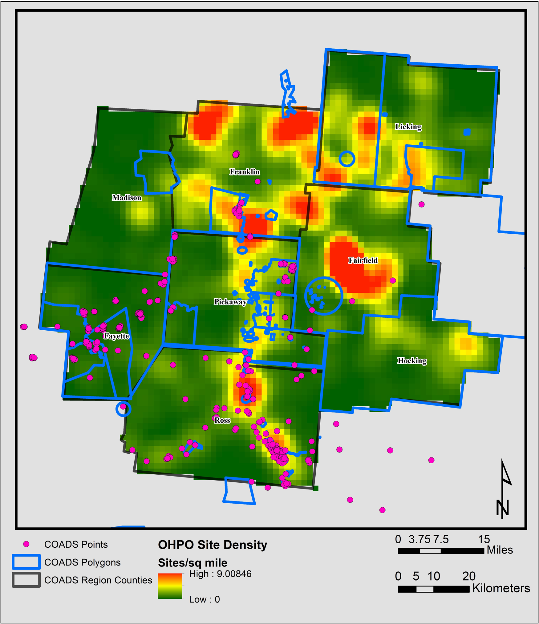
Figure 2. Distribution of COADS recorded sites over Ohio Archaeological Inventory density surface (see Nolan Reference Nolan2014). Note that some collectors reported collections from outside the COADS region.
COLLABORATION AND BIG DATA IN ARCHAEOLOGY
COADS leveraged only some of the tremendous quantity of information that resides in RRS collections. Jonathan Bowen's (Reference Bowen2015) extensive work with RRS is another example of productive collaboration with RRS. COADS's analyses, already in progress, will continue for some time. At this remove, we can only sketch some of the major lines of research planned for this dataset. At the outset, however, we emphasize one of its properties: it is big.
Big Data
VanValkenburgh and Dufton (Reference VanValkenburgh and Dufton2020) illustrate the growing concern for archaeological inquiry built around “big” data. Here, we briefly sketch some contributions that COADS can make to big-data analyses that we expect to mature in the coming year. Crudely, for instance, we can compare COADS's relative proportion of points by type to other Midwestern sources in search of robust patterns or regional variation. But we can go well beyond this measure.
One focus in the COADS project is its analytical approach to 2D and 3D digital point models. It starts from the truism that stone is a reductive medium. Tools were made from pieces of stone larger than the intended product, carefully and incrementally struck to remove unwanted material, that gradually assumed the size and shape that the maker desired. Due to their use, tools often suffered edge-dulling and other damage in use that was reparable only by further—even more careful and incremental—resharpening to expose fresh, sharp tips and edges. In the process, of course, points became smaller in size and often changed somewhat in shape because resharpening typically occurred more frequently on their exposed tips and blades than on their hafts. Degree and pattern of such reduction via resharpening reflects the kind and amount of use that points experienced. These are important details of their use lives, whose analytical potential archaeologists only recently began to appreciate.
Accordingly, UA's focus in the COADS point database is on the ways that points are curated and reused to better understand changes in point morphology. We examine the kind and amount of use along with the reduction undergone by points of different types (and different time periods). This is the study of how and to what extent points of different types were curated, and what explains curation rates and patterns. It also encompasses the study, measurement, and explanation of “allometric” variation in points (change in shape with change in size; here, change in shape as points gradually were reduced in size by resharpening) and characteristic allometric trajectories of point types. We are conducting LGM analysis both on fully landmarked 2D and 3D digital models and on the same models trimmed or truncated to remove the blade. Although both blade and stem are subject to reduction allometry, there are good reasons to believe that most reduction occurs on blades. Therefore, it is important to conduct parallel analysis and to compare results between whole-object and stem-only models of the same points. Analysis is generating type-specific degrees and patterns of reduction and associated curation rates. Combined with data on site numbers, distributions and settings, and regional subsistence-settlement trends, allometric patterns and curation rates can be correlated with broader cultural trends and hypotheses—for instance, higher curation rates as populations became more sedentary—tested. (For analysis of land-use scale using collector-derived stone tools from Ohio, see Seeman et al. Reference Seeman, Colucci and Fulk2020.)
More experimentally, we study how point types of earlier periods might have morphed or “evolved” into later types by long-term processes of intelligent trial-and-error experimentation in contexts of prehistoric cultural and environmental change. Archaeology still cannot explain how Early Archaic Kirk points changed into later MacCorkle or Stanly types, or the morphometric transformations of Early Woodland Adena to Middle Woodland Hopewell Snyders points. Nor can we explain why such changes occurred as they did and in response to what causes. We also remain unable to distinguish between sequences of point types characterized by in situ development and “evolution” from the abrupt replacement of one type by another as the result of population movements or the abandonment of regions followed by their subsequent reoccupations of groups of different cultural and technological traditions.
Archaeology lacks, that is, a nearly sufficient theory of the point (Shott Reference Shott and Groucutt2020), its causes, and its trajectories of change. No single research project can remedy this deficiency, but COADS makes a modest start. Using its data, we can propose tentative answers to questions such as, How can we distinguish between anagenesis (one type morphing into a single descendant type) and cladogenesis (one type branching into two or more descendants) in point-type transitions? Are there Bauplan constraints that channel the direction and magnitude of morphometric transformation from one type to a descendant? Can we measure the correlation, if any, between direction, rate, and magnitude of paleoenvironmental trends and morphometric changes—at least at point-type transitions (e.g., Conolly Reference Conolly2018)? These are examples of “macroarchaeological” investigation (Perreault Reference Perreault2019), a reframing and rescaling of research questions that COADS and similarly conceived big-data projects accomplish by compiling datasets of the size and quality found in aggregate RRS collections.
COLLABORATION IN PRACTICE AND IN PRINCIPLE
COADS has proven a success in RRS–professional collaboration, but not a perfect one. In Ohio, where private collecting and professional archaeology sometimes have clashed, some collectors are skeptical of collaboration with archaeologists. In one unfortunate episode, prominent members of the collector-community ASO initially offered, then publicly withdrew, cooperation. There is a long history of fraught relations between professionals and some collectors in Ohio—one for which many on both sides of the tragic and contrived divide share the blame. In our experience, however, these issues stem more from a lack of rapport and bad personal relationships than from a general distrust of archaeologists. Fortunately, many ASO members who are RRS made their own determinations about the constructive sharing of information from the collections under their stewardship.
Generally, RRS were willing and interested in participating only if they built a relationship or rapport with COADS staff or with Bowen. Cold-calling rarely yielded positive response. Additional recruitment techniques included staffing a table at the Center for Science and Industry—a large science museum in Columbus—attending ASO regional chapter meetings, creating a Facebook page for the project, and encouraging RRS collaborators to let their friends know we were interested in working with them. We also reached out to YouTube channels and internet forums. Few of these efforts yielded useful results.
Ultimately, COADS's collaboration with RRS was akin to community-engaged scholarship. Olson and Nolan spent much of their visits chatting with RRS not about collections but other topics. The key to successful collaboration is to treat RRS as people, not just sources of data. People want to share their collections with acquaintances or friends—not strangers. This is especially true when common themes heard at ASO meetings and among some collectors are the unfounded fears of bad faith or (just as bad) the failure to acknowledge the work of RRS. Many new relationships were built on the vouching of others: “If so-and-so trusts you, I can too.” In the end, the amount and quality of cooperation received from COADS collaborators was both remarkable and gratifying. As in our collective past experience, it was a pleasure to work with such enthusiastic students of Ohio prehistory. These people welcomed us into their homes, letting us assemble our mobile lab to analyze some of the fruits of their labor. They shared stories, their time, and sometimes even meals with us.
RRS–professional collaboration must not be a one-way process in which professionals document RRS-supplied information for their legitimate research purposes. If we expect RRS to collaborate with us, we must reciprocate, not only, of course, by acknowledgments that are customary in scholarly publications but also by opening to them databases (possibly of sites and certainly of digital models of points) compiled by professionals. (Of course, this measure does not extend to open availability of any documentation, including digital point models, whose RRS sources do not want the information to be disseminated.) This is only fair. In addition, it may be wise, because the more responsible heads conducting either baseline or advanced research, the better we can preserve the remaining record, and the more all of us can learn about prehistory.
There are no federally recognized tribes with headquarters or trust land in Ohio, although several have active interests in the precontact record of modern Ohio and the COADS region. We recognize the importance of preservation of the record of Indigenous history in the COADS region, and we promote and open lines of communication with our community partners about research plans and products. Although no specific consultation with federally recognized tribes was conducted about COADS, Nolan and the Applied Anthropology Laboratories maintain active communication with multiple tribal communities on numerous collaborative and co-creative projects (Nolan and Bello Reference Nolan and Bello2021; Thompson and Nolan Reference Thompson and Nolan2018; Thompson et al. Reference Thompson, Nolan and Halfmoon2018, Reference Thompson, Knapke, Obermeyer, Hunter, Alligood, Barry and Bussler2021). We remain open to input and discussion, and we understand the importance of cultivating productive discussion across diverse sets of stakeholders.
COADS demonstrates the abundance and richness of central Ohio's precontact record and is part of a holistic, nuanced analysis of the region's history. As attitudes toward American archaeology and preservation continue to evolve, all stakeholders— descendant communities, archaeologists, RRS, and American society at large—together must engage in reciprocal discourse to balance varied interests. Sometimes these may compete, but discussion always should occur in a climate of respect for the diversity of views held and practices followed, mindful of archaeology's scientific status as codified in the Society for American Archaeology's (SAA; 1996) ethical standards and consistent with the sincere regard we show to the ancient people who lived here by the effort we invest to understand the past for the benefit of our common future.
COADS also engages the matter of professional ethics, but perhaps not as all archaeologists think. With the goal of “not adding commercial value to archaeological . . . objects,” the SAA conditions publication of materials “that (1) have been obtained without systematic descriptions of their context [and] (2) [have been] recovered in such a manner as to cause unscientific destruction of sites” (Society for American Archaeology 2018:7) on review by editors. Depending on their documentary quality, private collections might be construed as lacking “systematic descriptions of their context,” and their acquisition as causing “unscientific destruction.” Narrowly, we might argue that no such objects are described or illustrated here, and that our collaborations will not—to our knowledge—promote commercialization. Yet, the first point strains to rationalize; after all, COADS data and research require capturing artifact images, which in other cases might lack context and whose collection, per the second point, might promote destruction of the record.
We justify our use of data from private collections instead by engaging the larger issues entailed (see also Pitblado Reference Pitblado2014:386–391; Shott and Pitblado Reference Shott and Pitblado2015:12). Recalling that all artifacts were collected from the surfaces of cultivated fields, we consider that documented RRS collections possess at least minimum “systematic descriptions of context” (as above, minimal documentary quality was a precondition for collaboration) and therefore that their compilation caused no “unscientific destruction.” But even this justification is narrow. Widespread private collection is a reality that archaeology cannot prevent and should not ignore.
Private individuals possess a sizable and informative fraction of the archaeological record, whatever we advise or wish. Deliberate disregard of that part of the record constitutes its own variety of neglect. Indeed, we read the SAA's (1996) code of ethics not merely to permit but positively to require professionals to collaborate reasonably with RRS to document their collections as resources in both the study of prehistory and the preservation of its record. Principle 1, Stewardship, explicitly encompasses collections, not just in situ materials, in its definition of the record that it enjoins professionals to preserve. Principle 7, Records and Preservation, requires professionals “actively” to encourage “responsible use of collections” and to increase “the care and attention given to that portion of the archaeological record which has been . . . incorporated into archaeological collections” (Society for American Archaeology 1996). In COADS's context, documenting collections causes no unscientific destruction. On the contrary, their neglect would occasion its own destruction of a substantial and informative segment of the total record, whose compilation professionals could not prevent and whose disregard would reduce scientific understanding and other appreciations of the cultural past.
IMPLICATIONS FOR PRESERVATION PRACTICE
In Ohio, as elsewhere in North America, by far most archaeological investigation is mandated by public policy and statute (in the United States, the National Historic Preservation Act [NHPA] of 1966, amended 1980, particularly Section 106, and its implementing regulation 36CFR800). Standards for CRM investigations have evolved since 1966, mostly for the better. Yet, in one respect, those standards have failed to consider an important part of the archaeological record. They enjoin archaeologists to document the material record as far as reasonably possible. But for over a century, much of that record has been collected by other people, notably RRS. We can do little to access and document the record collected by uncooperative and irresponsible collectors. Still, the many RRS distributed across the United States hold large—admittedly selective—portions of the record. Yet, their collections and the information that resides in them are rarely documented in Section 106 investigations. Indeed, considering the often severe time and budget constraints under which most CRM archaeology is conducted, effort to document such collections is penalized; it engages opportunity costs in the time and effort not devoted to other equally (but not always more) important project tasks (see Nolan et al. Reference Nolan, Leak, Quimbach, Shott, Seeman and Nolan2018).
Section 106 enjoins archaeologists to evaluate the impact of federal projects on properties eligible for or listed on the National Register of Historic Places (NRHP). RRS private collections comprise a not insignificant part of that database. Accordingly, and consistent with NHPA and in the spirit of historic preservation that it embodies, accessible RRS collections compiled at least in part from project areas should be considered an integral component of the material record when evaluating adverse effects on properties eligible for the NRHP. As Nolan and colleagues (Reference Nolan, Leak, Quimbach, Shott, Seeman and Nolan2018) and Olson (Reference Olson2019) showed, data residing in RRS collections can bear directly on Phase I documentation and Phase II evaluation of NRHP eligibility of cultural remains. For instance, places that appear, in conventional Phase I survey, to be “nondiagnostic flake scatters” may in fact have already been surveyed by RRS and diagnostic materials collected before archaeologists enter the field. This means that systematic efforts to reach out to, coordinate with, and document the RRS collections acquired from project areas are integral to Phase II evaluation; they should be part of Section 106 investigations. We must survey the ground but also the local collectors. Of course, this effort will require the development of standards, for kind and amount of effort involved in outreach to RRS communities, for technical data-capture methods, and perhaps in other respects as well.
From our COADS experiences, main concerns differ between RRS and professional archaeologists. A primary concern to RRS is recognition and acknowledgment. Specifics of documentation standards must await contemplation and discussion among CRM archaeologists and RRS, but it is essential that they always include proper acknowledgment. The important point at this remove is that already compiled collections of artifacts should be documented systematically in the course of CRM and other professional investigations.
CONCLUSION
In the longest view, we hope that COADS marks only a brief moment in archaeology's history. The data acquired, leveraging the substantial collections compiled and curated by RRS, are both unusually large and, with some obvious limitations, of a quality suitable for addressing urgent research questions in archaeology. Besides its research potential, however, COADS demonstrates both that private RRS collections have great value and that many RRS—devoted as they are to the serious, responsible study of North American prehistory—are a willing resource in that endeavor. Whatever the contestation that characterized past engagement between professionals and collectors, the future belongs to productive and constructive collaboration. Nothing less will suffice for the fullest preservation possible of the extant material record and for intelligent research by all parties, professionals and RRS alike, that is vital to progress in archaeology.
Acknowledgments
We gratefully acknowledge funding from the National Science Foundation (BCS 1723879 and BCS 1723877). COADS was possible only with the advice and support of Dr. Jonathan E. Bowen; Gary Argabright; Richard and Harriet McClish; the Archaeological Society of Ohio chapters at Chert Ridge, Mound City, Six River Valley, and Standing Stone; the numerous collectors who invited us into their homes and allowed us to document their collections and associated information—including Gary Argabright, Don Balthaser, John Barnhart, Fayette County Historical Society, Licking Valley Heritage Society, Richard McClish, John Mears, Moundview Farm, Quiverfull Farm, Tom Schroeder, and Robert Wraley—and collectors who have chosen to remain anonymous. Three anonymous reviewers offered comments that improved the article.
Data Availability Statement
GIS products described are available via the links in the works cited. Digital models are available via the link in Shott and colleagues (Reference Shott, Weiland, Olson, Wathen, Clark, Travis, Ritter and Nolan2017). Remaining data are available via links in Olson and colleagues (Reference Olson, Nolan and Shott2021).


